CPAC: FERNANDA - Post-Tropical
Moderator: S2k Moderators
-
Sciencerocks
- Category 5

- Posts: 7286
- Age: 38
- Joined: Thu Jul 06, 2017 1:51 am
-
Sciencerocks
- Category 5
- Posts: 7286
- Age: 38
- Joined: Thu Jul 06, 2017 1:51 am
Re: EPAC: FERNANDA - Hurricane
000
WTPZ41 KNHC 200846
TCDEP1
Tropical Storm Fernanda Discussion Number 34
NWS National Hurricane Center Miami FL EP062017
200 AM PDT Thu Jul 20 2017
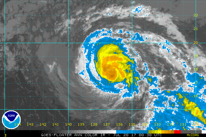
Fernanda is beginning to experience moderate southwesterly vertical
wind shear, which has resulted in a pronounced degradation of the
convective cloud pattern since the previous advisory. Recent AMSU
and SSMI/S microwave satellite data indicate that the shear has
tilted the vortex toward the north, resulting in the initial
position being located a little south of the satellite fix
positions and closer to the southwestern edge of the coldest cloud
tops. The initial intensity has been lowered to 60 kt based on a
blend of consensus T-numbers of T3.5/55 kt and CI-numbers of T4.0/65
kt from both TAFB and SAB.
Fernanda's motion is now 290/08 kt. The weakening cyclone is
expected to continue moving generally west-northwestward along the
southern periphery of a broad deep-layer subtropical ridge for about
the next 72 hours. By days 4 and 5, a faster westward motion is
forecast as the shallow vortex comes under the influence of the
brisk low-level easterly trade wind flow. The latest GFS model run
appears to keep Fernanda too strong and vertically deep after 48 h,
which has resulted in a track well north of any of the other model
guidance. As a result, the new NHC forecast has been shifted a
little south of the previous advisory track through 72 hours, and
is then close to the middle of the guidance envelope after that.
Fernanda should steadily succumb to the effects of cooler water,
drier air, and shear increasing to 30 kt throughout the forecast
period, resulting in weakening and degeneration into a remnant low
by around 48 hours. It is possible that the system could even open
up into a tropical wave by 96-120 hours when it is passing just
north of the Hawaiian Islands. The official intensity forecast is
similar to the previous advisory and closely follows the IVCN
consensus model.
FORECAST POSITIONS AND MAX WINDS
INIT 20/0900Z 18.2N 137.7W 60 KT 70 MPH
12H 20/1800Z 18.5N 138.9W 50 KT 60 MPH
24H 21/0600Z 19.0N 140.7W 40 KT 45 MPH
36H 21/1800Z 19.5N 142.5W 35 KT 40 MPH
48H 22/0600Z 20.1N 144.2W 30 KT 35 MPH...POST-TROP/REMNT LOW
72H 23/0600Z 21.6N 147.5W 25 KT 30 MPH...POST-TROP/REMNT LOW
96H 24/0600Z 22.7N 152.2W 25 KT 30 MPH...POST-TROP/REMNT LOW
120H 25/0600Z 23.8N 158.0W 25 KT 30 MPH...POST-TROP/REMNT LOW
$$
Forecaster Stewart
WTPZ41 KNHC 200846
TCDEP1
Tropical Storm Fernanda Discussion Number 34
NWS National Hurricane Center Miami FL EP062017
200 AM PDT Thu Jul 20 2017
Fernanda is beginning to experience moderate southwesterly vertical
wind shear, which has resulted in a pronounced degradation of the
convective cloud pattern since the previous advisory. Recent AMSU
and SSMI/S microwave satellite data indicate that the shear has
tilted the vortex toward the north, resulting in the initial
position being located a little south of the satellite fix
positions and closer to the southwestern edge of the coldest cloud
tops. The initial intensity has been lowered to 60 kt based on a
blend of consensus T-numbers of T3.5/55 kt and CI-numbers of T4.0/65
kt from both TAFB and SAB.
Fernanda's motion is now 290/08 kt. The weakening cyclone is
expected to continue moving generally west-northwestward along the
southern periphery of a broad deep-layer subtropical ridge for about
the next 72 hours. By days 4 and 5, a faster westward motion is
forecast as the shallow vortex comes under the influence of the
brisk low-level easterly trade wind flow. The latest GFS model run
appears to keep Fernanda too strong and vertically deep after 48 h,
which has resulted in a track well north of any of the other model
guidance. As a result, the new NHC forecast has been shifted a
little south of the previous advisory track through 72 hours, and
is then close to the middle of the guidance envelope after that.
Fernanda should steadily succumb to the effects of cooler water,
drier air, and shear increasing to 30 kt throughout the forecast
period, resulting in weakening and degeneration into a remnant low
by around 48 hours. It is possible that the system could even open
up into a tropical wave by 96-120 hours when it is passing just
north of the Hawaiian Islands. The official intensity forecast is
similar to the previous advisory and closely follows the IVCN
consensus model.
FORECAST POSITIONS AND MAX WINDS
INIT 20/0900Z 18.2N 137.7W 60 KT 70 MPH
12H 20/1800Z 18.5N 138.9W 50 KT 60 MPH
24H 21/0600Z 19.0N 140.7W 40 KT 45 MPH
36H 21/1800Z 19.5N 142.5W 35 KT 40 MPH
48H 22/0600Z 20.1N 144.2W 30 KT 35 MPH...POST-TROP/REMNT LOW
72H 23/0600Z 21.6N 147.5W 25 KT 30 MPH...POST-TROP/REMNT LOW
96H 24/0600Z 22.7N 152.2W 25 KT 30 MPH...POST-TROP/REMNT LOW
120H 25/0600Z 23.8N 158.0W 25 KT 30 MPH...POST-TROP/REMNT LOW
$$
Forecaster Stewart
0 likes
-
cycloneye

- Admin

- Posts: 139060
- Age: 67
- Joined: Thu Oct 10, 2002 10:54 am
- Location: San Juan, Puerto Rico
Re: EPAC: FERNANDA - Tropical Storm
Tropical Storm Fernanda Discussion Number 35
NWS National Hurricane Center Miami FL EP062017
800 AM PDT Thu Jul 20 2017
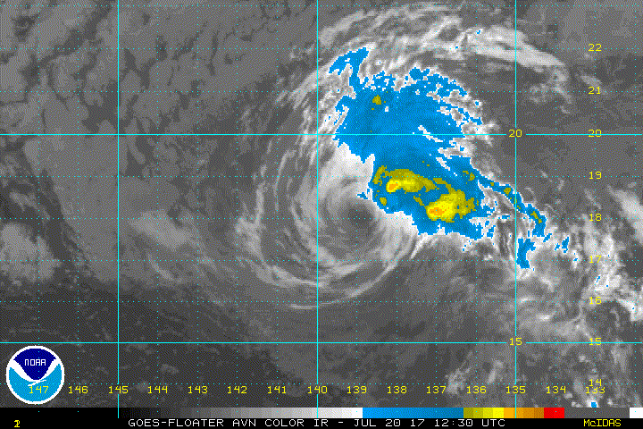
Since the last advisory, Fernanda has become significantly sheared
with the low-level center now exposed to the southwest of a rather
small area of deep convection. The initial intensity is reduced to
55 kt based on various satellite intensity estimates, and it is
possible that this is generous. While the sea surface temperatures
along the forecast track should increase, a combination of
continued moderate-to-strong shear and entrainment of dry air
should keep Fernanda steadily weakening through the forecast
period. The cyclone is forecast to weaken to a depression in 24-36
h and degenerate into a remnant low shortly thereafter, with the
new intensity forecast being an update of the previous forecast.
The now-exposed center is a little west of the previous advisory
position, and the initial motion is now 285/8. Fernanda is
expected to move generally west-northwestward through the forecast
period as the increasingly weak and shallow vortex is steered by
the low-level trade winds. The new forecast track is parallel to,
but south of, the previous track based on the current position and
motion. However, it lies to the north of the consensus models and
the center of the guidance envelope, and if current trends continue
some additional southward adjustment of the track could occur later
today.
FORECAST POSITIONS AND MAX WINDS
INIT 20/1500Z 18.2N 139.2W 55 KT 65 MPH
12H 21/0000Z 18.6N 140.6W 45 KT 50 MPH
24H 21/1200Z 19.0N 142.4W 35 KT 40 MPH
36H 22/0000Z 19.5N 144.1W 30 KT 35 MPH
48H 22/1200Z 20.1N 145.8W 25 KT 30 MPH...POST-TROP/REMNT LOW
72H 23/1200Z 21.5N 149.5W 25 KT 30 MPH...POST-TROP/REMNT LOW
96H 24/1200Z 22.5N 154.5W 25 KT 30 MPH...POST-TROP/REMNT LOW
120H 25/1200Z 24.0N 160.5W 20 KT 25 MPH...POST-TROP/REMNT LOW
$$
Forecaster Beven
NWS National Hurricane Center Miami FL EP062017
800 AM PDT Thu Jul 20 2017
Since the last advisory, Fernanda has become significantly sheared
with the low-level center now exposed to the southwest of a rather
small area of deep convection. The initial intensity is reduced to
55 kt based on various satellite intensity estimates, and it is
possible that this is generous. While the sea surface temperatures
along the forecast track should increase, a combination of
continued moderate-to-strong shear and entrainment of dry air
should keep Fernanda steadily weakening through the forecast
period. The cyclone is forecast to weaken to a depression in 24-36
h and degenerate into a remnant low shortly thereafter, with the
new intensity forecast being an update of the previous forecast.
The now-exposed center is a little west of the previous advisory
position, and the initial motion is now 285/8. Fernanda is
expected to move generally west-northwestward through the forecast
period as the increasingly weak and shallow vortex is steered by
the low-level trade winds. The new forecast track is parallel to,
but south of, the previous track based on the current position and
motion. However, it lies to the north of the consensus models and
the center of the guidance envelope, and if current trends continue
some additional southward adjustment of the track could occur later
today.
FORECAST POSITIONS AND MAX WINDS
INIT 20/1500Z 18.2N 139.2W 55 KT 65 MPH
12H 21/0000Z 18.6N 140.6W 45 KT 50 MPH
24H 21/1200Z 19.0N 142.4W 35 KT 40 MPH
36H 22/0000Z 19.5N 144.1W 30 KT 35 MPH
48H 22/1200Z 20.1N 145.8W 25 KT 30 MPH...POST-TROP/REMNT LOW
72H 23/1200Z 21.5N 149.5W 25 KT 30 MPH...POST-TROP/REMNT LOW
96H 24/1200Z 22.5N 154.5W 25 KT 30 MPH...POST-TROP/REMNT LOW
120H 25/1200Z 24.0N 160.5W 20 KT 25 MPH...POST-TROP/REMNT LOW
$$
Forecaster Beven
0 likes
Visit the Caribbean-Central America Weather Thread where you can find at first post web cams,radars
and observations from Caribbean basin members Click Here
and observations from Caribbean basin members Click Here
-
Sciencerocks
- Category 5
- Posts: 7286
- Age: 38
- Joined: Thu Jul 06, 2017 1:51 am
-
Sciencerocks
- Category 5
- Posts: 7286
- Age: 38
- Joined: Thu Jul 06, 2017 1:51 am
Re: EPAC: FERNANDA - Tropical Storm
000
WTPZ41 KNHC 202036
TCDEP1
Tropical Storm Fernanda Discussion Number 36
NWS National Hurricane Center Miami FL EP062017
200 PM PDT Thu Jul 20 2017
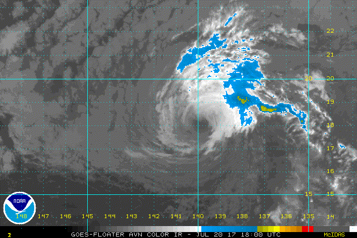
Fernanda is comprised of a swirl of low- to mid-level clouds that
is currently devoid of deep convection. The initial intensity is
reduced to 50 kt based on various satellite intensity estimates, and
it is again possible that this is generous. While the sea surface
temperatures along the forecast track should increase, a combination
of continued moderate-to-strong shear and entrainment of dry air
should keep Fernanda steadily weakening through the forecast
period. The cyclone is now forecast to become a depression in
about 24 h and a remnant low in about 36 h, and both of these events
could occur earlier if convection does not redevelop. The new
intensity forecast also now calls for the system to degenerate to a
trough after 96 h, in agreement with all of the large-scale models
except the GFS.
The initial motion is now 280/11. Fernanda is expected to move
west-northwestward to westward through the forecast period as the
increasingly weak and shallow vortex is steered by the low-level
trade winds. The new forecast track is shifted a little to the
south of the previous forecast based on the current motion and the
premise that a weaker system will move more westward in the current
environment. The new track now lies a little to the south of the
model consensus.
This is the last advisory issued by the National Hurricane Center
on Fernanda. Future information on this system can be found in
Public Advisories issued by the Central Pacific Hurricane Center
beginning at 5 PM HST, under AWIPS header HFOTCPCP1, WMO header
WTPA31 PHFO, and on the web at http://www.prh.noaa.gov/cphc.
FORECAST POSITIONS AND MAX WINDS
INIT 20/2100Z 18.2N 140.4W 50 KT 60 MPH
12H 21/0600Z 18.5N 141.9W 40 KT 45 MPH
24H 21/1800Z 19.0N 143.7W 30 KT 35 MPH
36H 22/0600Z 19.6N 145.4W 25 KT 30 MPH...POST-TROP/REMNT LOW
48H 22/1800Z 20.2N 147.3W 25 KT 30 MPH...POST-TROP/REMNT LOW
72H 23/1800Z 21.5N 151.5W 25 KT 30 MPH...POST-TROP/REMNT LOW
96H 24/1800Z 22.5N 156.5W 20 KT 25 MPH...POST-TROP/REMNT LOW
120H 25/1800Z...DISSIPATED
$$
Forecaster Beven
WTPZ41 KNHC 202036
TCDEP1
Tropical Storm Fernanda Discussion Number 36
NWS National Hurricane Center Miami FL EP062017
200 PM PDT Thu Jul 20 2017
Fernanda is comprised of a swirl of low- to mid-level clouds that
is currently devoid of deep convection. The initial intensity is
reduced to 50 kt based on various satellite intensity estimates, and
it is again possible that this is generous. While the sea surface
temperatures along the forecast track should increase, a combination
of continued moderate-to-strong shear and entrainment of dry air
should keep Fernanda steadily weakening through the forecast
period. The cyclone is now forecast to become a depression in
about 24 h and a remnant low in about 36 h, and both of these events
could occur earlier if convection does not redevelop. The new
intensity forecast also now calls for the system to degenerate to a
trough after 96 h, in agreement with all of the large-scale models
except the GFS.
The initial motion is now 280/11. Fernanda is expected to move
west-northwestward to westward through the forecast period as the
increasingly weak and shallow vortex is steered by the low-level
trade winds. The new forecast track is shifted a little to the
south of the previous forecast based on the current motion and the
premise that a weaker system will move more westward in the current
environment. The new track now lies a little to the south of the
model consensus.
This is the last advisory issued by the National Hurricane Center
on Fernanda. Future information on this system can be found in
Public Advisories issued by the Central Pacific Hurricane Center
beginning at 5 PM HST, under AWIPS header HFOTCPCP1, WMO header
WTPA31 PHFO, and on the web at http://www.prh.noaa.gov/cphc.
FORECAST POSITIONS AND MAX WINDS
INIT 20/2100Z 18.2N 140.4W 50 KT 60 MPH
12H 21/0600Z 18.5N 141.9W 40 KT 45 MPH
24H 21/1800Z 19.0N 143.7W 30 KT 35 MPH
36H 22/0600Z 19.6N 145.4W 25 KT 30 MPH...POST-TROP/REMNT LOW
48H 22/1800Z 20.2N 147.3W 25 KT 30 MPH...POST-TROP/REMNT LOW
72H 23/1800Z 21.5N 151.5W 25 KT 30 MPH...POST-TROP/REMNT LOW
96H 24/1800Z 22.5N 156.5W 20 KT 25 MPH...POST-TROP/REMNT LOW
120H 25/1800Z...DISSIPATED
$$
Forecaster Beven
0 likes
-
WeatherGuesser
- Category 5
- Posts: 2672
- Joined: Tue Jun 29, 2010 6:46 am
Re: CPAC: FERNANDA - Tropical Storm
Well, at least it stayed as a named storm for the crossover.
1 likes

Re: CPAC: FERNANDA - Tropical Storm
Far from her glory days a week ago. These EPAC canes once they hit cooler, stable conditions you get to see the cool mature structures below.

0 likes
The above post and any post by Ntxw is NOT an official forecast and should not be used as such. It is just the opinion of the poster and may or may not be backed by sound meteorological data. It is NOT endorsed by any professional institution including Storm2k. For official information, please refer to NWS products.
Help support Storm2K!

-
Sciencerocks
- Category 5
- Posts: 7286
- Age: 38
- Joined: Thu Jul 06, 2017 1:51 am


-
Sciencerocks
- Category 5
- Posts: 7286
- Age: 38
- Joined: Thu Jul 06, 2017 1:51 am
-
Sciencerocks
- Category 5
- Posts: 7286
- Age: 38
- Joined: Thu Jul 06, 2017 1:51 am
Re: CPAC: FERNANDA - Tropical Storm
earlier advisory!
TPA41 PHFO 210240
TCDCP1
Tropical Storm Fernanda Discussion Number 37
NWS Central Pacific Hurricane Center Honolulu HI EP062017
500 PM HST Thu Jul 20 2017
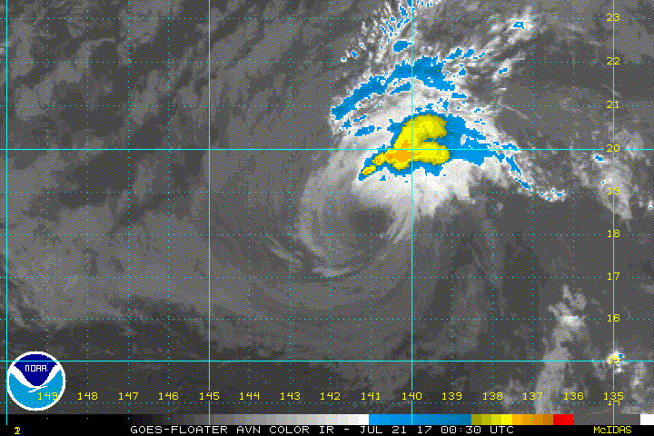
Most of the deep convection near the center of Fernanda has
dissipated leaving an exposed low level circulation center
surrounded by mostly low- and mid-level clouds. The remaining
thunderstorms are confined to an outer rainband more than 60 nm
north of the center. The initial intensity is 45 kt which is
slightly weaker than the previous advisory. This may be conservative
but an ASCAT pass from 1936 UTC sampled the northwestern portion of
the circulation and found 40 kt. Subjective Dvorak estimates from
PHFO and SAB came in at 35 kt but this may be too aggressive a drop
at this time.
The initial motion for this package is 280/10 kt with steering
increasingly dictated by the low level flow. The main dynamical
aids show a fair amount of spread. The GFS, and to a lesser
degree HWRF, continue to hold on to a stronger and deeper system
which results in a more northwestward track. This doesn't appear
to be reasonable given the environmental circumstances. Thus, the
forecast track leans more toward the ECMWF solution and is close to
the previous forecast, keeping Fernanda on a general westward to
west-northwestward motion through the forecast period.
Fernanda is tracking over waters near 25C. Along the forecast track,
sea surface temperature are to remain in the 25C to 26C range. The
cyclone is also expected to stay within strong vertical shear
conditions of about 25 to 35 kt through the next 3 days.
Although some deep convection may occasionally flare up near
the center, the more likely outcome under these environmental
conditions is for Fernanda to continue to weaken and eventually
dissipate. This expectation is consistent with the SHIPS
guidance. The forecast calls for continued weakening with Fernanda
becoming a remnant low during the next 24 to 36 hours, then opening
up to a trough after 72 hours.
FORECAST POSITIONS AND MAX WINDS
INIT 21/0300Z 18.4N 141.4W 45 KT 50 MPH
12H 21/1200Z 18.8N 142.9W 35 KT 40 MPH
24H 22/0000Z 19.3N 144.8W 30 KT 35 MPH
36H 22/1200Z 19.9N 146.6W 25 KT 30 MPH...POST-TROP/REMNT LOW
48H 23/0000Z 20.5N 148.4W 25 KT 30 MPH...POST-TROP/REMNT LOW
72H 24/0000Z 21.8N 153.0W 25 KT 30 MPH...POST-TROP/REMNT LOW
96H 25/0000Z...DISSIPATED
$$
Forecaster Kodama
TPA41 PHFO 210240
TCDCP1
Tropical Storm Fernanda Discussion Number 37
NWS Central Pacific Hurricane Center Honolulu HI EP062017
500 PM HST Thu Jul 20 2017
Most of the deep convection near the center of Fernanda has
dissipated leaving an exposed low level circulation center
surrounded by mostly low- and mid-level clouds. The remaining
thunderstorms are confined to an outer rainband more than 60 nm
north of the center. The initial intensity is 45 kt which is
slightly weaker than the previous advisory. This may be conservative
but an ASCAT pass from 1936 UTC sampled the northwestern portion of
the circulation and found 40 kt. Subjective Dvorak estimates from
PHFO and SAB came in at 35 kt but this may be too aggressive a drop
at this time.
The initial motion for this package is 280/10 kt with steering
increasingly dictated by the low level flow. The main dynamical
aids show a fair amount of spread. The GFS, and to a lesser
degree HWRF, continue to hold on to a stronger and deeper system
which results in a more northwestward track. This doesn't appear
to be reasonable given the environmental circumstances. Thus, the
forecast track leans more toward the ECMWF solution and is close to
the previous forecast, keeping Fernanda on a general westward to
west-northwestward motion through the forecast period.
Fernanda is tracking over waters near 25C. Along the forecast track,
sea surface temperature are to remain in the 25C to 26C range. The
cyclone is also expected to stay within strong vertical shear
conditions of about 25 to 35 kt through the next 3 days.
Although some deep convection may occasionally flare up near
the center, the more likely outcome under these environmental
conditions is for Fernanda to continue to weaken and eventually
dissipate. This expectation is consistent with the SHIPS
guidance. The forecast calls for continued weakening with Fernanda
becoming a remnant low during the next 24 to 36 hours, then opening
up to a trough after 72 hours.
FORECAST POSITIONS AND MAX WINDS
INIT 21/0300Z 18.4N 141.4W 45 KT 50 MPH
12H 21/1200Z 18.8N 142.9W 35 KT 40 MPH
24H 22/0000Z 19.3N 144.8W 30 KT 35 MPH
36H 22/1200Z 19.9N 146.6W 25 KT 30 MPH...POST-TROP/REMNT LOW
48H 23/0000Z 20.5N 148.4W 25 KT 30 MPH...POST-TROP/REMNT LOW
72H 24/0000Z 21.8N 153.0W 25 KT 30 MPH...POST-TROP/REMNT LOW
96H 25/0000Z...DISSIPATED
$$
Forecaster Kodama
0 likes
-
Sciencerocks
- Category 5
- Posts: 7286
- Age: 38
- Joined: Thu Jul 06, 2017 1:51 am
Re: CPAC: FERNANDA - Tropical Storm
WTPA41 PHFO 210850
TCDCP1
Tropical Storm Fernanda Discussion Number 38
NWS Central Pacific Hurricane Center Honolulu HI EP062017
1100 PM HST Thu Jul 20 2017
Deep convection has flared up this evening to the northeast of the
low level circulation center of Fernanda. The latest subjective
Dvorak intensity estimates from PHFO and SAB came in at 35 and 30
knots respectively, likely too low given the slow spin down time of
these systems. Given the improvement in appearance of Fernanda
since the previous advisory, the initial intensity will be held at
45 knots for this package.
The initial motion for this advisory is 280/10 kt. The spread
between the reliable guidance remains large. The GFS continues
to show a stronger and deeper system tracking off to the
west-northwest for the next 12 hours and then toward the northwest
for the next several days thereafter around the southwestern
periphery of a strong sub-tropical ridge. The ECMWF and HWRF on the
other hand, show a more shallow system steered along primarily by
the low level trade wind flow. Given the unfavorable environmental
conditions, the forecast track is very close to the previous
official forecast, and closely in line with the ECMWF and HWRF
solutions. As a result, the forecast track takes Fernanda off to
the west-northwest through the forecast period.
Fernanda remains in an unfavorable environment, with sea surface
temperatures around 25C, very dry air aloft as evident in water
vapor imagery, as well as strong southwesterly shear of around 30
knots. Strong shear of 25 to 35 kt, very dry air aloft, and
unfavorable sea surface temperatures hovering between 25 and 26C are
forecast to remain over the system through the forecast period. As a
result, the forecast will continue to show slow and steady
weakening, with Fernanda expected to become a Tropical Depression in
12 to 24 hours, a remnant low in 24 to 36 hours, then dissipating
after 72 hours.
FORECAST POSITIONS AND MAX WINDS
INIT 21/0900Z 18.4N 142.5W 45 KT 50 MPH
12H 21/1800Z 18.9N 144.0W 35 KT 40 MPH
24H 22/0600Z 19.5N 145.9W 30 KT 35 MPH
36H 22/1800Z 20.1N 147.7W 25 KT 30 MPH...POST-TROP/REMNT LOW
48H 23/0600Z 20.7N 150.0W 25 KT 30 MPH...POST-TROP/REMNT LOW
72H 24/0600Z 22.0N 155.0W 25 KT 30 MPH...POST-TROP/REMNT LOW
96H 25/0600Z...DISSIPATED
$$
Forecaster Jelsema
0 likes
-
Yellow Evan

- Professional-Met

- Posts: 15951
- Age: 25
- Joined: Fri Jul 15, 2011 12:48 pm
- Location: Henderson, Nevada/Honolulu, HI
- Contact:
Re: CPAC: FERNANDA - Tropical Storm
WTPA41 PHFO 211452
TCDCP1
Tropical Storm Fernanda Discussion Number 39
NWS Central Pacific Hurricane Center Honolulu HI EP062017
500 AM HST Fri Jul 21 2017
Deep convection persisted to the northeast of Fernanda overnight,
but separated further from the low level circulation center (LLCC)
due to increasing southwesterly shear. The latest subjective Dvorak
intensity estimates from PHFO and SAB came in at 35 and 25 knots
respectively, with the Advanced Dvorak Technique (ADT) from
UW-CIMSS coming in with 33 knots. These values are likely still a
bit too low given the slow spin down time of these systems. Given
the increasing shear and resultant separation of the deep convection
from the LLCC however, the initial intensity has been lowered to 40
knots for this advisory package.
The initial motion for this advisory is 280/10 kt. The spread
between the reliable guidance remains large. The GFS continues to
show a stronger and deeper system tracking off toward the northwest
for the next several days around the southwestern periphery of a
strong sub-tropical ridge. The ECMWF and to a lesser extent the
HWRF and FSSE objective aids, show a more shallow system steered
along primarily by the low level trade wind flow. The GFEX and TVCN
consensus guidance appear to be influenced too far to the north due
to the outlier GFS solution. Given the unfavorable environmental
conditions, the forecast track is very close to the previous
official forecast, closely in line with the ECMWF solution, and to
the south of the consensus guidance. As a result, the forecast track
takes Fernanda off to the west-northwest through the forecast
period.
Fernanda remains in an unfavorable environment, with sea surface
temperatures around 25C, very dry air aloft as evident in water
vapor imagery, as well as strong southwesterly shear of around 35
knots. Strong shear of 25 to 35 kt, very dry air aloft, and
unfavorable sea surface temperatures hovering between 25 and 26C
are forecast to persist through the forecast period. As a result,
the forecast will continue to show slow and steady weakening, with
Fernanda expected to become a Tropical Depression in 12 to 24
hours, a remnant low in 24 to 36 hours, then dissipating after 72
hours.
FORECAST POSITIONS AND MAX WINDS
INIT 21/1500Z 18.6N 143.6W 40 KT 45 MPH
12H 22/0000Z 19.0N 145.0W 35 KT 40 MPH
24H 22/1200Z 19.5N 146.7W 30 KT 35 MPH
36H 23/0000Z 20.1N 148.6W 25 KT 30 MPH...POST-TROP/REMNT LOW
48H 23/1200Z 20.7N 150.7W 25 KT 30 MPH...POST-TROP/REMNT LOW
72H 24/1200Z 22.1N 155.9W 25 KT 30 MPH...POST-TROP/REMNT LOW
96H 25/1200Z...DISSIPATED
$$
Forecaster Jelsema
0 likes
-
Sciencerocks
- Category 5
- Posts: 7286
- Age: 38
- Joined: Thu Jul 06, 2017 1:51 am
Re: CPAC: FERNANDA - Tropical Storm
WT
PA41 PHFO 212052
TCDCP1
Tropical Storm Fernanda Discussion Number 40
NWS Central Pacific Hurricane Center Honolulu HI EP062017
1100 AM HST Fri Jul 21 2017
Fernanda presents poorly in satellite imagery. Deep convection
remains within the northeast quadrant of Fernanda's low level
circulation center (LLCC), ranging from 40 to 110 nm, as this system
feels the effects of strong southwesterly shear. Subjective Dvorak
satellite intensity estimates range from 25 kt, from SAB, to 35 kt,
from PHFO. UW-CIMSS provided an ADT intensity of 25 kt. It is too
early for a timely ASCAT pass, so we will assign a potentially
generous 35 kt as the initial system intensity in keeping with the
overall poor appearance and continued weakening trend.
Initial motion is 280/07kt, representing a bit of slowing over the
past 12 hours, as Fernanda moves westward along the southern flank
of the subtropical ridge. A weakness in the ridge west of 160W
continues to allow Fernanda to gain latitude, although quite
slowly. Track quidance, once the unrepresentitive GFS and its
associated blends are removed, is rather tight, depicting a shallow
system moving generally westward to west northwestward within low
level steering flow. The forecast track closely follows the
previous one, but is nudged ever so slightly to the left at 24 and
36 hours to account for the ECMWF leftward shift through those
times. The 48 hour forecast is almost unchanged, with system
dissipation expected afterward. Note that on this forecast track,
Fernanda is not forecast to reach the longitude of the main Hawaiian
Islands as an intact tropical system.
Fernanda remains in an unfavorable environment, with sea surface
temperatures around 25C and between 30 and 35 knots of southwesterly
shear. These conditions will persist along the forecast track. As a
result, the forecast is for slow and steady weakening, with Fernanda
expected to become a tropical depression in 12 hours, a remnant low
at 36 hours, then dissipate after 48 hours.
FORECAST POSITIONS AND MAX WINDS
INIT 21/2100Z 18.7N 144.3W 35 KT 40 MPH
12H 22/0600Z 19.0N 145.6W 30 KT 35 MPH
24H 22/1800Z 19.6N 147.5W 30 KT 35 MPH
36H 23/0600Z 20.2N 149.5W 25 KT 30 MPH...POST-TROP/REMNT LOW
48H 23/1800Z 20.9N 151.8W 20 KT 25 MPH...POST-TROP/REMNT LOW
72H 24/1800Z...DISSIPATED
$$
Forecaster Powell
0 likes
-
Sciencerocks
- Category 5
- Posts: 7286
- Age: 38
- Joined: Thu Jul 06, 2017 1:51 am
Re: CPAC: FERNANDA - Tropical Storm
Convection attempting to cover the LLC again. May give it another 6-12 hours of life!
1 likes
-
Kingarabian

- S2K Supporter

- Posts: 15434
- Joined: Sat Aug 08, 2009 3:06 am
- Location: Honolulu, Hawaii
Re: CPAC: FERNANDA - Tropical Storm
She's really close to 30 units at a little over 28. A little longer and she could push 30
1 likes
The above post and any post by Ntxw is NOT an official forecast and should not be used as such. It is just the opinion of the poster and may or may not be backed by sound meteorological data. It is NOT endorsed by any professional institution including Storm2k. For official information, please refer to NWS products.
Help support Storm2K!
Help support Storm2K!
-
Yellow Evan
- Professional-Met
- Posts: 15951
- Age: 25
- Joined: Fri Jul 15, 2011 12:48 pm
- Location: Henderson, Nevada/Honolulu, HI
- Contact:
Re: CPAC: FERNANDA - Tropical Storm
* EAST PACIFIC SHIPS INTENSITY FORECAST *
* IR SAT DATA AVAILABLE, OHC AVAILABLE *
* FERNANDA EP062017 07/22/17 00 UTC *
TIME (HR) 0 6 12 18 24 36 48 60 72 84 96 108 120
V (KT) NO LAND 30 27 25 23 22 17 DIS DIS DIS DIS DIS DIS DIS
V (KT) LAND 30 27 25 23 22 17 DIS DIS DIS DIS DIS DIS DIS
V (KT) LGEM 30 26 23 21 19 16 DIS DIS DIS DIS DIS DIS DIS
Storm Type TROP TROP TROP TROP TROP TROP TROP N/A N/A N/A N/A N/A N/A
SHEAR (KT) 23 24 27 33 39 36 27 N/A N/A N/A N/A N/A N/A
SHEAR ADJ (KT) 3 5 7 3 -1 3 9 N/A N/A N/A N/A N/A N/A
SHEAR DIR 219 212 214 211 211 224 230 N/A N/A N/A N/A N/A N/A
SST (C) 25.2 25.3 25.4 25.5 25.6 26.0 26.3 N/A N/A N/A N/A N/A N/A
POT. INT. (KT) 114 116 117 118 119 124 127 N/A N/A N/A N/A N/A N/A
200 MB T (C) -53.8 -54.0 -54.2 -54.1 -53.9 -54.3 -55.2 N/A N/A N/A N/A N/A N/A
200 MB VXT (C) 0.7 0.8 0.8 0.6 0.4 -0.2 -0.1 N/A N/A N/A N/A N/A N/A
TH_E DEV (C) 6 6 6 6 7 8 9 N/A N/A N/A N/A N/A N/A
700-500 MB RH 45 41 40 38 38 38 37 N/A N/A N/A N/A N/A N/A
MODEL VTX (KT) 13 14 13 13 13 11 9 LOST LOST LOST LOST LOST LOST
850 MB ENV VOR 11 12 7 6 0 0 -22 N/A N/A N/A N/A N/A N/A
200 MB DIV 13 17 16 15 0 -12 17 N/A N/A N/A N/A N/A N/A
700-850 TADV 7 7 8 9 9 4 5 N/A N/A N/A N/A N/A N/A
LAND (KM) 1093 996 901 795 693 488 300 N/A N/A N/A N/A N/A N/A
LAT (DEG N) 18.9 19.2 19.4 19.8 20.1 20.7 21.4 N/A N/A N/A N/A N/A N/A
LONG(DEG W) 144.4 145.3 146.2 147.2 148.2 150.3 152.7 N/A N/A N/A N/A N/A N/A
STM SPEED (KT) 8 9 9 10 10 11 12 N/A N/A N/A N/A N/A N/A
HEAT CONTENT 0 0 0 0 0 0 2 0 0 0 0 0 0
FORECAST TRACK FROM OFCI INITIAL HEADING/SPEED (DEG/KT):285/ 7 CX,CY: -6/ 2
T-12 MAX WIND: 40 PRESSURE OF STEERING LEVEL (MB): 696 (MEAN=550)
GOES IR BRIGHTNESS TEMP. STD DEV. 50-200 KM RAD: 18.4 (MEAN=14.5)
% GOES IR PIXELS WITH T < -20 C 50-200 KM RAD: 22.0 (MEAN=65.0)
PRELIM RI PROB (DV .GE. 55 KT IN 48 HR): 0.0
INDIVIDUAL CONTRIBUTIONS TO INTENSITY CHANGE
6 12 18 24 36 48 60 72 84 96 108 120
----------------------------------------------------------
SAMPLE MEAN CHANGE 0. 0. 1. 1. 1. 1. 1. 1. -0. -1. -1. -2.
SST POTENTIAL 0. 1. 2. 2. 5. 9. 13. 16. 18. 20. 21. 19.
VERTICAL SHEAR MAG 0. 1. 0. -1. -5. -10. -19. -27. -35. -39. -39. -38.
VERTICAL SHEAR ADJ -0. -1. -1. -1. -1. -2. -1. -1. -1. -0. -0. -0.
VERTICAL SHEAR DIR -0. -1. -1. -1. -2. -2. -2. -2. -3. -3. -4. -4.
PERSISTENCE -2. -4. -5. -6. -6. -6. -5. -4. -3. -2. 0. 2.
200/250 MB TEMP. 0. 0. 1. 1. 3. 5. 7. 9. 10. 10. 9. 9.
THETA_E EXCESS -0. -0. -0. 0. 0. 1. 1. 1. 2. 2. 2. 2.
700-500 MB RH -0. -0. -1. -1. -1. -2. -3. -4. -5. -6. -8. -9.
MODEL VTX TENDENCY 0. 0. 1. 0. -2. -5. -5. -5. -5. -4. -4. -4.
850 MB ENV VORTICITY 0. 0. 0. 0. 0. 0. 1. 1. 1. 1. 1. 1.
200 MB DIVERGENCE -0. -0. -1. -1. -2. -3. -3. -3. -3. -3. -2. -2.
850-700 T ADVEC 0. 0. -0. -0. 0. 0. 1. 1. 2. 3. 4. 5.
ZONAL STORM MOTION -0. -0. -0. -0. -0. -0. -0. -0. -0. -0. -0. -0.
STEERING LEVEL PRES 0. 1. 1. 2. 2. 3. 3. 3. 3. 4. 3. 3.
DAYS FROM CLIM. PEAK -0. -0. -0. -0. 0. -0. -0. -0. -1. -1. -1. -1.
GOES PREDICTORS -1. -2. -2. -3. -4. -6. -8. -8. -7. -7. -8. -8.
OCEAN HEAT CONTENT -0. -1. -1. -1. -2. -2. -2. -1. -1. -1. -1. 0.
----------------------------------------------------------
TOTAL CHANGE -3. -5. -7. -8. -13. -18. -21. -24. -27. -28. -28. -26.
CURRENT MAX WIND (KT): 30. LAT, LON: 18.9 144.4
** 2017 E.PACIFIC RI INDEX EP062017 FERNANDA 07/22/17 00 UTC **
(SHIPS-RII PREDICTOR TABLE for 30 KT OR MORE MAXIMUM WIND INCREASE IN NEXT 24-h)
Predictor Value RI Predictor Range Scaled Value(0-1) % Contribution
12 HR PERSISTENCE (KT): -10.0 -22.0 to 44.0 0.18 999.0
POT = MPI-VMAX (KT) : 86.9 40.5 to 149.3 0.43 999.0
850-200 MB SHEAR (KT) : 29.2 18.9 to 1.4 0.00 0.0
HEAT CONTENT (KJ/cm2) : 0.0 0.0 to 106.7 0.00 0.0
MAXIMUM WIND (kt) : 30.0 22.5 to 132.0 0.21 999.0
D200 (10**7s-1) : 12.2 -33.0 to 156.2 0.24 999.0
STD DEV OF IR BR TEMP : 18.4 37.8 to 2.1 0.54 999.0
% AREA WITH TPW <45 mm: 48.3 62.3 to 0.0 0.22 999.0
2nd PC OF IR BR TEMP : -1.1 2.2 to -1.9 0.80 999.0
BL DRY-AIR FLUX (w/m2): 260.2 735.9 to -82.5 0.58 999.0
SHIPS Prob RI for 20kt/ 12hr RI threshold= 0% is 0.0 times sample mean ( 7.7%)
SHIPS Prob RI for 25kt/ 24hr RI threshold= 0% is 0.0 times sample mean (15.3%)
SHIPS Prob RI for 30kt/ 24hr RI threshold= 0% is 0.0 times sample mean (10.4%)
SHIPS Prob RI for 35kt/ 24hr RI threshold= 0% is 0.0 times sample mean ( 7.5%)
SHIPS Prob RI for 40kt/ 24hr RI threshold= 0% is 0.0 times sample mean ( 5.2%)
SHIPS Prob RI for 45kt/ 36hr RI threshold= 0% is 0.0 times sample mean ( 8.1%)
SHIPS Prob RI for 55kt/ 48hr RI threshold= 0% is 0.0 times sample mean ( 7.4%)
SHIPS Prob RI for 65kt/ 72hr RI threshold= 0% is 0.0 times sample mean ( 5.5%)
Matrix of RI probabilities
------------------------------------------------------------------------------
RI (kt / h) | 20/12 | 25/24 | 30/24 | 35/24 | 40/24 | 45/36 | 55/48 |65/72
------------------------------------------------------------------------------
SHIPS-RII: 0.0% 0.0% 0.0% 0.0% 0.0% 0.0% 0.0% 0.0%
Logistic: 0.0% 0.0% 0.0% 0.0% 0.0% 0.0% 0.0% 0.0%
Bayesian: 0.0% 0.0% 0.0% 0.0% 0.0% 0.0% 0.0% 0.0%
Consensus: 0.0% 0.0% 0.0% 0.0% 0.0% 0.0% 0.0% 0.0%
## ANNULAR HURRICANE INDEX (AHI) EP062017 FERNANDA 07/22/17 00 UTC ##
## STORM NOT ANNULAR, SCREENING STEP FAILED, NPASS=4 NFAIL=3 ##
## AHI= 0 (AHI OF 100 IS BEST FIT TO ANN. STRUC., 1 IS MARGINAL, 0 IS NOT ANNULAR) ##
0 likes
-
Sciencerocks
- Category 5
- Posts: 7286
- Age: 38
- Joined: Thu Jul 06, 2017 1:51 am
Re: CPAC: FERNANDA - Tropical Storm
WTPA41 PHFO 220237
TCDCP1
Tropical Depression Fernanda Discussion Number 41
NWS Central Pacific Hurricane Center Honolulu HI EP062017
500 PM HST Fri Jul 21 2017
Fernanda's presentation continues to worsen in satellite imagery.
Deep convection remains within the northeast quadrant of Fernanda's
low level circulation center (LLCC), but the western half of the
circulation is beginning to open up as low clouds dissipate.
Subjective Dvorak satellite intensity estimates range from 25 kt,
from SAB, to 30 kt, from PHFO. UW-CIMSS provided an ADT intensity of
30 kt. ASCAT missed this system, but cloud motion imagery shows no
more than 35 kt at low cloud level along the western edge of the
LLCC. Reduction to 30 kt at the surface seems reasonable and is
therefore the initial intensity for this round. Fernanda is now a
tropical depression.
Initial motion is 285/07kt, representing a stronger northerly
component to motion over the past 6 to 12 hours. Fernanda is moving
along the southern flank of the subtropical ridge, gradually gaining
latitude as it approaches a weakness in the ridge west of 160W. The
spread in track guidance decreased with this cycle as GFS belatedly
shifted leftward. ECMWF also shifted leftward, but much less so,
allowing the total envelope to narrow noticeably. NAVGEM and GFS
are the left and right outliers, respectively, with ECMWF just
to the right of NAVGEM. The forecast track closely follows the
previous one through 36 hours, but shifts to the left at 48 hours to
follow the guidance envelope trend. This places the track close to
but to the right of ECMWF, which has served us nicely so far. This
track terminates with system dissipation after 48 hours, before it
reaches the longitude of the main Hawaiian Islands.
Fernanda remains in an unfavorable environment, with sea surface
temperatures around 25C and between 30 and 35 knots of southwesterly
shear. These conditions will persist along the forecast track. As a
result, the forecast calls for steady weakening. Fernanda is
expected to become a remnant low in 24 hours, then dissipate after
48 hours.
FORECAST POSITIONS AND MAX WINDS
INIT 22/0300Z 19.0N 144.8W 30 KT 35 MPH
12H 22/1200Z 19.4N 146.2W 30 KT 35 MPH
24H 23/0000Z 20.0N 148.2W 25 KT 30 MPH...POST-TROP/REMNT LOW
36H 23/1200Z 20.6N 150.3W 20 KT 25 MPH...POST-TROP/REMNT LOW
48H 24/0000Z 20.9N 152.5W 20 KT 25 MPH...POST-TROP/REMNT LOW
72H 25/0000Z...DISSIPATED
$$
Forecaster Powell
0 likes
-
cycloneye
- Admin
- Posts: 139060
- Age: 67
- Joined: Thu Oct 10, 2002 10:54 am
- Location: San Juan, Puerto Rico
Re: CPAC: FERNANDA - Tropical Storm
Tropical Storm Fernanda Discussion Number 43
NWS Central Pacific Hurricane Center Honolulu HI EP062017
500 AM HST Sat Jul 22 2017
The satellite presentation of Fernanda continues to indicate a
strongly sheared system, with the low level circulation center
(LLCC) devoid of deep convection for nearly 6 hours prior to a
recent small burst of convective development to the north of the
storm. The latest subjective Dvorak intensity estimates came in at
25 knots from PHFO, too weak to classify from SAB, with the ADT
intensity from UW-CIMSS also coming in at 25 knots. Despite the
lack of any significant convection overnight, we have kept
Fernanda, perhaps conservatively as a minimal Tropical Storm for
this advisory based on the 22/0640Z ASCAT pass which showed a small
area of 35 knot winds to the north of the LLCC.
The initial motion for this advisory is 280/8 kt, representing an
increase in the west-northwestward motion since the previous
advisory. The GFS continues to be the northern outlier solution,
with the ECMWF solution the farthest to the south. Very hostile
environmental conditions will remain over Fernanda over the next
couple of days, keeping the system shallow with the track
influenced primarily by the low level trade wind flow. As a result,
the forecast track for this advisory will remain very close to that
of the previous advisory, keeping it to the south of the GFEX and
TVCN consensus aids that are likely too far north due to the
influence from the outlier GFS solution. A general motion toward the
west-northwest with an increase in forward speed is expected
through system dissipation.
Fernanda remains in an unfavorable environment with sea surface
temperatures between 25 and 26C, very dry air aloft as evident in
water vapor imagery, as well as strong southwesterly shear of
around 30 knots. Strong shear of 30 to 40 knots, very dry air aloft,
and unfavorable sea surface temperatures hovering between 25 and 26C
are expected to persist through the forecast period, and will
eventually lead to the dissipation of Fernanda. As a result, the
forecast will continue to show slow and steady weakening, with
Fernanda expected to become a Tropical Depression later today and a
remnant low tonight, with dissipation forecast after 36 hours.
FORECAST POSITIONS AND MAX WINDS
INIT 22/1500Z 19.1N 146.4W 35 KT 40 MPH
12H 23/0000Z 19.5N 148.0W 30 KT 35 MPH
24H 23/1200Z 19.9N 150.2W 30 KT 35 MPH...POST-TROP/REMNT LOW
36H 24/0000Z 20.2N 153.0W 25 KT 30 MPH...POST-TROP/REMNT LOW
48H 24/1200Z...DISSIPATED
$$
Forecaster Jelsema
0 likes
Visit the Caribbean-Central America Weather Thread where you can find at first post web cams,radars
and observations from Caribbean basin members Click Here
and observations from Caribbean basin members Click Here
Who is online
Users browsing this forum: No registered users and 103 guests