EPAC: GREG - Post-Tropical
Moderator: S2k Moderators
-
TheStormExpert

- Category 5

- Posts: 8487
- Age: 30
- Joined: Wed Feb 16, 2011 5:38 pm
- Location: Palm Beach Gardens, FL
Re: EPAC: SEVEN-E - Tropical Depression
This and Adrian makes two TC's in the East Pacific so far this season getting their skin ripped off. This has to be some kind of record for this basin! 
0 likes
The following post is NOT an official forecast and should not be used as such. It is just the opinion of the poster and may or may not be backed by sound meteorological data. It is NOT endorsed by storm2k.org.
-
Sciencerocks
- Category 5
- Posts: 7285
- Age: 38
- Joined: Thu Jul 06, 2017 1:51 am
Re: EPAC: SEVEN-E - Tropical Depression
000
WTPZ42 KNHC 180252
TCDEP2
Tropical Depression Seven-E Discussion Number 3
NWS National Hurricane Center Miami FL EP072017
900 PM MDT Mon Jul 17 2017
Although the center of circulation appears to have separated from
the cloud canopy a little more this evening, satellite imagery shows
very little change in the disorganized cloud pattern of the
depression. A compromise of Dvorak satellite intensity estimates
from both TAFB and SAB again support holding an intensity of 30 kt
for this advisory. The strong west-northwesterly shear is forecast
to decrease somewhat during the next 24 to 36 hours which should
allow the cyclone to intensify a little. The large-scale models and
the statistical-dynamical intensity guidance show the vertical shear
returning around the 72-hour period, in addition to the depression
moving over cooler water. Subsequently, the official forecast
reflects the aforementioned environmental changes and indicates a
gradual spin-down into a remnant low beyond the 48-hour period.
The initial motion is estimated to be 280/8 kt, similar to the
previous package. The depression is forecast to move westward to
west-northwestward to the south of an anchored mid-level ridge that
stretches westward from northwestern Mexico. The global and
regional models are in quite good agreement through day 3.
Afterward, there is some increasing spread between the majority of
the guidance and the HWRF. The HWRF is indicating some
involvement with the disturbance between Fernanda and the
depression, and in fact, shows the disturbance merging with the
depression. The official track forecast, however, discounts this
scenario at this time, and is nudged closer to the model cluster and
the HFIP corrected consensus model.
FORECAST POSITIONS AND MAX WINDS
INIT 18/0300Z 14.3N 106.9W 30 KT 35 MPH
12H 18/1200Z 14.5N 108.1W 35 KT 40 MPH
24H 19/0000Z 14.8N 109.8W 40 KT 45 MPH
36H 19/1200Z 15.1N 111.7W 40 KT 45 MPH
48H 20/0000Z 15.5N 113.8W 40 KT 45 MPH
72H 21/0000Z 16.4N 118.6W 35 KT 40 MPH
96H 22/0000Z 16.7N 123.6W 30 KT 35 MPH
120H 23/0000Z 16.5N 128.5W 25 KT 30 MPH...POST-TROP/REMNT LOW
$$
Forecaster Roberts
0 likes
-
Sciencerocks
- Category 5
- Posts: 7285
- Age: 38
- Joined: Thu Jul 06, 2017 1:51 am
-
Sciencerocks
- Category 5
- Posts: 7285
- Age: 38
- Joined: Thu Jul 06, 2017 1:51 am
Re: EPAC: SEVEN-E - Tropical Depression
000
WTPZ42 KNHC 180840
TCDEP2
Tropical Storm Greg Discussion Number 4
NWS National Hurricane Center Miami FL EP072017
300 AM MDT Tue Jul 18 2017
Deep convection has increased in both intensity and coverage during
the last several hours over and to the southeast of the center of
the cyclone. The Dvorak classifications from TAFB and SAB at 0600
UTC were 2.0/30 kt, but ADT values and satellite consensus estimates
from CIMSS at the University of Wisconsin suggest a slightly higher
intensity. Based on the improvement in convective organization
during the past few hours, the initial intensity is increased to 35
kt, making the system Tropical Storm Greg.
The northwesterly shear currently affecting Greg is expected to
gradually lessen, and the upper-level wind pattern will likely
become favorable in the 24- to 60-h time frame. Therefore, the NHC
intensity forecast continues to show modest strengthening during the
next couple of days. After that time, however, the shear is
expected to increase out of the south or southwest as the cyclone
approaches an upper-level low. This increase in shear combined with
drier air and cooler waters should end the strengthening trend and
cause weakening. The depression will likely degenerate to a remnant
low in 4 to 5 days when it moves over SSTs below 26 deg C. The NHC
intensity forecast is the same as the previous one, and is in line
with the bulk of the guidance.
Greg is moving west-northwestward at 8 kt to the south of a low- to
mid-level ridge. A westward to west-northwestward motion with some
increase in forward speed is expected during the next few days as
the ridge strengthens a little. Some of the models show Greg
interacting with the disturbance currently located about 700 n mi
to its west in 4 to 5 days, which could cause the cyclone to turn
south of due west at that time. The track models are in general
agreement, and the NHC forecast lies closest to the consensus aids.
FORECAST POSITIONS AND MAX WINDS
INIT 18/0900Z 14.6N 107.6W 35 KT 40 MPH
12H 18/1800Z 14.7N 108.7W 35 KT 40 MPH
24H 19/0600Z 15.0N 110.6W 40 KT 45 MPH
36H 19/1800Z 15.4N 112.6W 40 KT 45 MPH
48H 20/0600Z 15.8N 114.7W 40 KT 45 MPH
72H 21/0600Z 16.9N 119.7W 35 KT 40 MPH
96H 22/0600Z 17.1N 124.6W 30 KT 35 MPH
120H 23/0600Z 16.5N 129.5W 25 KT 30 MPH...POST-TROP/REMNT LOW
$$
Forecaster Cangialosi
0 likes
-
Yellow Evan

- Professional-Met

- Posts: 15951
- Age: 25
- Joined: Fri Jul 15, 2011 12:48 pm
- Location: Henderson, Nevada/Honolulu, HI
- Contact:
Re: EPAC: SEVEN-E - Tropical Depression
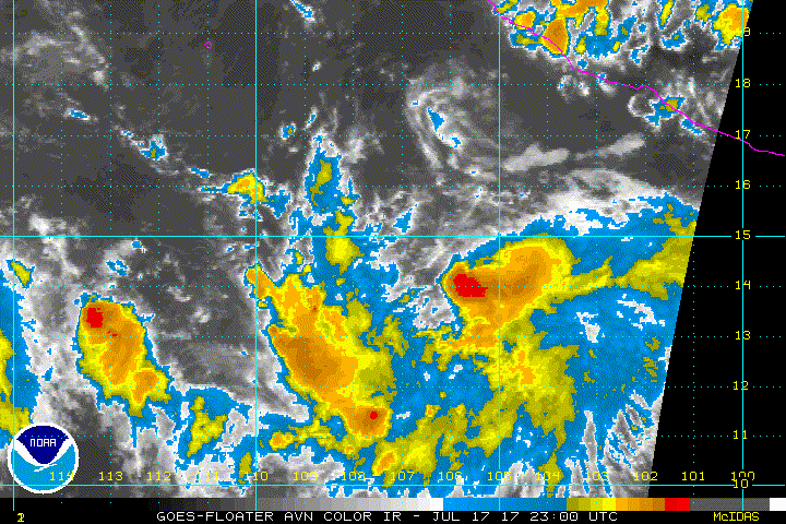
18/0545 UTC 14.6N 107.3W T2.0/2.0 07E -- East Pacific
0 likes
-
Yellow Evan
- Professional-Met
- Posts: 15951
- Age: 25
- Joined: Fri Jul 15, 2011 12:48 pm
- Location: Henderson, Nevada/Honolulu, HI
- Contact:
Re: EPAC: GREG - Tropical Storm
000
WTPZ42 KNHC 181436
TCDEP2
Tropical Storm Greg Discussion Number 5
NWS National Hurricane Center Miami FL EP072017
900 AM MDT Tue Jul 18 2017
Shear has lessened over the system and the center now appears to be
beneath the dense overcast. The intensity is held at 35 kt in
accordance with a Dvorak estimate from SAB. Gradual strengthening
is forecast while Greg moves over warm waters. Late in the period,
increasing shear and cooler waters should cause weakening. The
official intensity forecast is near or a little below the model
consensus.
Greg has been moving west-northwestward to the south of a mid-level
ridge. Although the ridge is expected to remain in place for the
next several days, a slight complicating factor in the track
forecast is a cyclone, newly formed Tropical Depression Eight-E,
located about 500 n mi to the west of Greg. Some of the models
indicate that Greg could interact with the other cyclone in a few
days by turning south of west. The official forecast shows a
slightly south of westward motion in the latter part of the period.
This is roughly in the middle of the guidance envelope.
FORECAST POSITIONS AND MAX WINDS
INIT 18/1500Z 15.0N 108.3W 35 KT 40 MPH
12H 19/0000Z 15.2N 109.6W 40 KT 45 MPH
24H 19/1200Z 15.4N 111.4W 45 KT 50 MPH
36H 20/0000Z 15.7N 113.4W 50 KT 60 MPH
48H 20/1200Z 16.2N 115.7W 50 KT 60 MPH
72H 21/1200Z 17.5N 120.7W 40 KT 45 MPH
96H 22/1200Z 17.3N 125.6W 35 KT 40 MPH
120H 23/1200Z 17.0N 130.0W 25 KT 30 MPH...POST-TROP/REMNT LOW
$$
Forecaster Pasch
0 likes
-
Yellow Evan
- Professional-Met
- Posts: 15951
- Age: 25
- Joined: Fri Jul 15, 2011 12:48 pm
- Location: Henderson, Nevada/Honolulu, HI
- Contact:
-
Kingarabian

- S2K Supporter

- Posts: 15434
- Joined: Sat Aug 08, 2009 3:06 am
- Location: Honolulu, Hawaii
Re: EPAC: GREG - Tropical Storm
Structure has drastically improved. Our next hurricane?

1 likes
RIP Kobe Bryant

Re: EPAC: GREG - Tropical Storm
Kingarabian wrote:Structure has drastically improved. Our next hurricane?
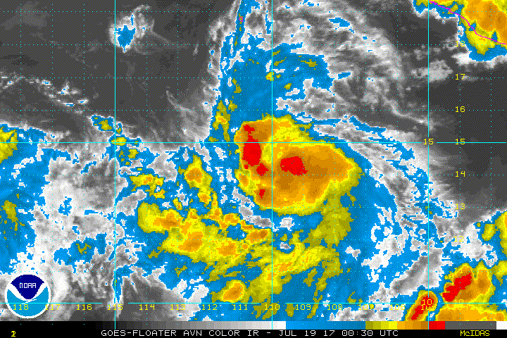
http://i.imgur.com/fnlbhmA.gif
It's much improved this evening with decreasing shear and sufficiently warm 28C waters. Structurally good below.

UW - CIMSS
ADVANCED DVORAK TECHNIQUE
ADT-Version 8.2.1
Tropical Cyclone Intensity Algorithm
----- Current Analysis -----
Date : 18 JUL 2017 Time : 233037 UTC
Lat : 14:37:56 N Lon : 109:22:19 W
CI# /Pressure/ Vmax
3.4 / 998.2mb/ 53.0kt
Final T# Adj T# Raw T#
3.3 3.5 3.5
Center Temp : -61.7C Cloud Region Temp : -62.1C
Scene Type : UNIFORM CDO CLOUD REGION
2 likes
The above post and any post by Ntxw is NOT an official forecast and should not be used as such. It is just the opinion of the poster and may or may not be backed by sound meteorological data. It is NOT endorsed by any professional institution including Storm2k. For official information, please refer to NWS products.
Help support Storm2K!

-
Kingarabian
- S2K Supporter
- Posts: 15434
- Joined: Sat Aug 08, 2009 3:06 am
- Location: Honolulu, Hawaii
Re: EPAC: GREG - Tropical Storm
Agreed. Well on its way to hurricane status. 
0 likes
RIP Kobe Bryant
-
Kingarabian
- S2K Supporter
- Posts: 15434
- Joined: Sat Aug 08, 2009 3:06 am
- Location: Honolulu, Hawaii

-
gatorcane

- S2K Supporter
- Posts: 23499
- Age: 46
- Joined: Sun Mar 13, 2005 3:54 pm
- Location: Boca Raton, FL
Re: EPAC: GREG - Tropical Storm
Yeah Greg is looking good real good. Looks like he wants to become a hurricane.
0 likes
-
Yellow Evan
- Professional-Met
- Posts: 15951
- Age: 25
- Joined: Fri Jul 15, 2011 12:48 pm
- Location: Henderson, Nevada/Honolulu, HI
- Contact:

Re: EPAC: GREG - Tropical Storm
A little stronger.

ATCF Best Track
System ID: EP07 (GREG)
0000 UTC Jul 19, 2017
Location: 14.6°N, 109.6°W
Central Pressure: 1003 mb
Maximum Winds (1-min): 45 kt (52 mph)
Type: Tropical Storm (TS)
ACE (Storm Total): 0.4475
System ID: EP07 (GREG)
0000 UTC Jul 19, 2017
Location: 14.6°N, 109.6°W
Central Pressure: 1003 mb
Maximum Winds (1-min): 45 kt (52 mph)
Type: Tropical Storm (TS)
ACE (Storm Total): 0.4475
0 likes
-
Yellow Evan
- Professional-Met
- Posts: 15951
- Age: 25
- Joined: Fri Jul 15, 2011 12:48 pm
- Location: Henderson, Nevada/Honolulu, HI
- Contact:
Re: EPAC: GREG - Tropical Storm
* EAST PACIFIC SHIPS INTENSITY FORECAST *
* IR SAT DATA AVAILABLE, OHC AVAILABLE *
* GREG EP072017 07/19/17 00 UTC *
TIME (HR) 0 6 12 18 24 36 48 60 72 84 96 108 120
V (KT) NO LAND 45 49 52 56 58 60 62 58 52 44 36 31 28
V (KT) LAND 45 49 52 56 58 60 62 58 52 44 36 31 28
V (KT) LGEM 45 49 52 54 56 56 56 53 47 40 33 29 25
Storm Type TROP TROP TROP TROP TROP TROP TROP TROP TROP TROP TROP TROP TROP
SHEAR (KT) 9 6 5 5 5 3 12 21 16 19 19 14 13
SHEAR ADJ (KT) -2 1 0 -2 -2 0 0 -2 1 -3 -4 -2 -2
SHEAR DIR 281 302 300 270 255 198 195 220 230 242 253 251 250
SST (C) 28.6 28.3 27.8 27.2 27.0 27.4 27.2 26.6 26.0 25.5 25.7 25.9 26.2
POT. INT. (KT) 150 147 142 136 134 139 137 131 124 119 121 122 125
200 MB T (C) -53.1 -53.3 -53.4 -53.2 -52.8 -53.1 -52.9 -53.3 -53.1 -53.2 -53.2 -53.3 -53.2
200 MB VXT (C) 0.1 0.3 0.4 0.4 0.3 0.2 0.1 -0.1 0.1 0.0 0.0 -0.1 -0.2
TH_E DEV (C) 7 7 7 7 7 7 6 5 4 4 5 5 6
700-500 MB RH 72 72 74 73 73 74 73 67 59 55 47 44 40
MODEL VTX (KT) 12 11 11 13 13 13 13 12 11 10 7 6 5
850 MB ENV VOR -7 1 10 14 18 26 31 38 42 43 44 51 33
200 MB DIV 24 21 16 11 16 37 29 27 15 9 -11 -4 -9
700-850 TADV 0 -1 0 1 0 0 8 12 10 2 5 2 6
LAND (KM) 722 788 863 905 919 1002 1137 1266 1461 1642 1850 2048 2233
LAT (DEG N) 14.6 14.8 14.9 15.2 15.4 15.8 16.5 17.2 17.6 17.6 17.2 16.7 16.2
LONG(DEG W) 109.6 110.6 111.6 112.7 113.7 115.9 118.7 121.4 124.1 126.6 128.9 130.9 132.7
STM SPEED (KT) 9 10 10 10 10 12 14 13 12 11 11 9 9
HEAT CONTENT 22 20 19 15 12 19 16 2 1 0 0 0 8
FORECAST TRACK FROM OFCI INITIAL HEADING/SPEED (DEG/KT):275/ 9 CX,CY: -8/ 1
T-12 MAX WIND: 35 PRESSURE OF STEERING LEVEL (MB): 570 (MEAN=550)
GOES IR BRIGHTNESS TEMP. STD DEV. 50-200 KM RAD: 12.3 (MEAN=14.5)
% GOES IR PIXELS WITH T < -20 C 50-200 KM RAD: 87.0 (MEAN=65.0)
PRELIM RI PROB (DV .GE. 55 KT IN 48 HR): 11.6
INDIVIDUAL CONTRIBUTIONS TO INTENSITY CHANGE
6 12 18 24 36 48 60 72 84 96 108 120
----------------------------------------------------------
SAMPLE MEAN CHANGE 0. 0. 1. 1. 1. 1. 1. 1. -0. -1. -1. -2.
SST POTENTIAL 1. 1. 3. 4. 6. 8. 10. 11. 12. 12. 11. 11.
VERTICAL SHEAR MAG 0. 1. 2. 3. 6. 7. 5. 3. 1. -1. -2. -2.
VERTICAL SHEAR ADJ -0. 0. 0. 0. 0. 0. 0. 0. 0. 0. 0. 0.
VERTICAL SHEAR DIR -1. -1. -2. -4. -6. -8. -9. -10. -11. -13. -14. -15.
PERSISTENCE 2. 3. 4. 4. 4. 4. 3. 2. 2. 1. 0. -0.
200/250 MB TEMP. 0. -0. -0. -0. -1. -1. -2. -2. -2. -2. -2. -2.
THETA_E EXCESS 0. 0. 0. 1. 1. 1. 1. 0. -1. -1. -2. -2.
700-500 MB RH 0. 0. 0. 0. 1. 1. 1. 2. 2. 1. 1. 0.
MODEL VTX TENDENCY -0. -0. 1. 2. 1. 2. 1. -0. -2. -5. -6. -7.
850 MB ENV VORTICITY 0. 0. 0. 0. 0. 0. 0. 0. 0. -0. -0. -0.
200 MB DIVERGENCE -0. -0. -1. -1. -1. -1. -1. -1. -1. -2. -2. -1.
850-700 T ADVEC 0. 0. -0. -0. 0. 0. 1. 1. 1. 2. 3. 4.
ZONAL STORM MOTION 0. 0. 0. 0. 1. 1. 1. 0. 0. 0. 0. 0.
STEERING LEVEL PRES 0. 0. 0. 0. 0. 0. 0. 0. 0. 0. 0. -0.
DAYS FROM CLIM. PEAK -0. -0. -0. -0. 0. -0. -0. -0. -1. -1. -1. -1.
GOES PREDICTORS 1. 2. 2. 2. 2. 2. 2. 1. 1. 0. 0. 0.
OCEAN HEAT CONTENT 0. 0. -0. -0. -0. -0. -0. -0. -0. -0. -0. 0.
----------------------------------------------------------
TOTAL CHANGE 4. 7. 11. 13. 15. 17. 13. 7. -1. -9. -14. -17.
CURRENT MAX WIND (KT): 45. LAT, LON: 14.6 109.6
** 2017 E.PACIFIC RI INDEX EP072017 GREG 07/19/17 00 UTC **
(SHIPS-RII PREDICTOR TABLE for 30 KT OR MORE MAXIMUM WIND INCREASE IN NEXT 24-h)
Predictor Value RI Predictor Range Scaled Value(0-1) % Contribution
12 HR PERSISTENCE (KT): 10.0 -22.0 to 44.0 0.48 4.5
POT = MPI-VMAX (KT) : 97.0 40.5 to 149.3 0.52 3.0
850-200 MB SHEAR (KT) : 6.0 18.9 to 1.4 0.74 5.9
HEAT CONTENT (KJ/cm2) : 17.6 0.0 to 106.7 0.16 1.0
MAXIMUM WIND (kt) : 45.0 22.5 to 132.0 0.64 3.8
D200 (10**7s-1) : 17.6 -33.0 to 156.2 0.27 1.4
STD DEV OF IR BR TEMP : 12.3 37.8 to 2.1 0.71 4.1
% AREA WITH TPW <45 mm: 0.0 62.3 to 0.0 1.00 -1.6
2nd PC OF IR BR TEMP : 0.7 2.2 to -1.9 0.37 0.2
BL DRY-AIR FLUX (w/m2): 127.4 735.9 to -82.5 0.74 0.0
SHIPS Prob RI for 20kt/ 12hr RI threshold= 19% is 2.5 times sample mean ( 7.7%)
SHIPS Prob RI for 25kt/ 24hr RI threshold= 29% is 1.9 times sample mean (15.3%)
SHIPS Prob RI for 30kt/ 24hr RI threshold= 22% is 2.1 times sample mean (10.4%)
SHIPS Prob RI for 35kt/ 24hr RI threshold= 19% is 2.5 times sample mean ( 7.5%)
SHIPS Prob RI for 40kt/ 24hr RI threshold= 17% is 3.2 times sample mean ( 5.2%)
SHIPS Prob RI for 45kt/ 36hr RI threshold= 24% is 3.0 times sample mean ( 8.1%)
SHIPS Prob RI for 55kt/ 48hr RI threshold= 20% is 2.7 times sample mean ( 7.4%)
SHIPS Prob RI for 65kt/ 72hr RI threshold= 9% is 1.7 times sample mean ( 5.5%)
Matrix of RI probabilities
------------------------------------------------------------------------------
RI (kt / h) | 20/12 | 25/24 | 30/24 | 35/24 | 40/24 | 45/36 | 55/48 |65/72
------------------------------------------------------------------------------
SHIPS-RII: 19.0% 28.8% 22.3% 18.6% 16.6% 24.0% 20.2% 9.5%
Logistic: 18.6% 29.8% 17.1% 16.1% 13.2% 15.9% 11.1% 2.6%
Bayesian: 1.1% 39.0% 14.5% 5.9% 2.3% 7.3% 7.1% 0.1%
Consensus: 12.9% 32.6% 18.0% 13.6% 10.7% 15.7% 12.8% 4.1%
## ANNULAR HURRICANE INDEX (AHI) EP072017 GREG 07/19/17 00 UTC ##
## STORM NOT ANNULAR, SCREENING STEP FAILED, NPASS=4 NFAIL=3 ##
## AHI= 0 (AHI OF 100 IS BEST FIT TO ANN. STRUC., 1 IS MARGINAL, 0 IS NOT ANNULAR) ##
0 likes
-
cycloneye

- Admin

- Posts: 139055
- Age: 67
- Joined: Thu Oct 10, 2002 10:54 am
- Location: San Juan, Puerto Rico
Re: EPAC: GREG - Tropical Storm
ropical Storm Greg Discussion Number 7
NWS National Hurricane Center Miami FL EP072017
900 PM MDT Tue Jul 18 2017
The convective organization of Greg has improved this evening. A
band consisting of cloud tops colder than -70C wrapping about 3/4 of
the way around the circulation is apparent in IR imagery. Dvorak
current intensity estimates from TAFB and SAB have increased to 45
knots, so the initial intensity has been increased to that value.
Despite the presence of a large upper-level low to the north east
and outflow from nearby Fernanda and TD Eight-E, the analyzed shear
over the center of Greg remains low. The low shear, combined with
warm SSTs and a fairly moist environment should allow for at least
modest intensification for the next 24-48 hours. After that time, a
combination of factors including a drier and more stable
environment, interaction with TD Eight-E, and increased shear
associated with the upper-level low should cause weakening and the
eventual dissipation of the tropical storm. The current forecast
is close to the model consensus and assumes that Greg will be the
dominant cyclone in any interaction with TD Eight-E. Weakening
would probably occur sooner if the opposite scenario occurred.
A 2316 UTC SSMIS overpass was very helpful in locating the center of
Greg, which was a little farther west than previously estimated.
The initial motion is now 275/9 kt. Although no significant changes
have been made to the track forecast, confidence remains fairly
low, especially beyond 72 hours. For the next 24 hours, there is
good agreement that Greg will move generally westward, along the
southern periphery of a mid-level ridge. Although the extent of
the interaction varies, the ECMWF, GFS, and UKMET all show some
degree of a Fujiwhara-type interaction with TD Eight-E. This
interaction, coupled with a slight weakening of the ridge, should
cause Greg to move a little farther north and more quickly toward
the west during days 2 and 3. A turn back toward the west-southwest
is shown at the end of the forecast, assuming at least some
continued interaction with the remnants of TD Eight-E. The forecast
is closest to a blend of the GFS and ECMWF models.
FORECAST POSITIONS AND MAX WINDS
INIT 19/0300Z 14.6N 110.1W 45 KT 50 MPH
12H 19/1200Z 14.8N 111.5W 50 KT 60 MPH
24H 20/0000Z 15.2N 113.4W 55 KT 65 MPH
36H 20/1200Z 15.8N 115.6W 55 KT 65 MPH
48H 21/0000Z 16.5N 118.1W 55 KT 65 MPH
72H 22/0000Z 17.4N 123.7W 45 KT 50 MPH
96H 23/0000Z 16.8N 128.1W 30 KT 35 MPH
120H 24/0000Z 15.5N 132.0W 25 KT 30 MPH...POST-TROP/REMNT LOW
$$
Forecaster Zelinsky
0 likes
Visit the Caribbean-Central America Weather Thread where you can find at first post web cams,radars
and observations from Caribbean basin members Click Here
and observations from Caribbean basin members Click Here
-
Sciencerocks
- Category 5
- Posts: 7285
- Age: 38
- Joined: Thu Jul 06, 2017 1:51 am
-
dexterlabio
- Category 5
- Posts: 3406
- Joined: Sat Oct 24, 2009 11:50 pm
Re: EPAC: GREG - Tropical Storm
After Fernanda, it looks like none of our current EPAC cyclones are poised to be the next major canes. But I recall the models showing a series of hurricanes following Fernanda. Are we no longer expecting that scenario to come into play?
0 likes
Personal Forecast Disclaimer:
The posts in this forum are NOT official forecast and should not be used as such. They are just the opinion of the poster and may or may not be backed by sound meteorological data. They are NOT endorsed by any professional institution or storm2k.org. For official information, please refer to the NHC and NWS products.
The posts in this forum are NOT official forecast and should not be used as such. They are just the opinion of the poster and may or may not be backed by sound meteorological data. They are NOT endorsed by any professional institution or storm2k.org. For official information, please refer to the NHC and NWS products.
-
Sciencerocks
- Category 5
- Posts: 7285
- Age: 38
- Joined: Thu Jul 06, 2017 1:51 am
Re: EPAC: GREG - Tropical Storm
000
WTPZ42 KNHC 190858
TCDEP2
Tropical Storm Greg Discussion Number 8
NWS National Hurricane Center Miami FL EP072017
300 AM MDT Wed Jul 19 2017
The increased convective organization of Greg proved to be
short-lived. Although the SHIPS-analyzed shear remains low, the
cloud pattern now resembles that of a sheared tropical cyclone. A
0458 UTC ASCAT-B overpass caught the eastern half of the
circulation, showing no winds above 30 kt, while Dvorak-based
estimates of the current intensity range from 45 to 57 kt. The
initial intensity has only been lowered to 40 kt since the ASCAT
pass missed the western half of the circulation, but this could be
generous.
Based on the aforementioned ASCAT pass, the analyzed center of the
tropical storm has been shifted farther south, and the overall
track forecast nudged southward accordingly. While the reasoning
behind the forecast is unchanged, the model spread is still fairly
high, and run-to-run consistency is low. For instance, the 120-h
forecast points from the 18Z and 00Z GFS model differ by nearly 300
nmi. The CMC, ECMWF, GFS, and UKMET global models still show Greg
and TD Eight-E interacting to various degrees, with each cyclone
beginning to affect the others track in about 36 hours. This
interaction should ultimately cause Greg to accelerate toward the
west-northwest. After about 72 hours it is still assumed that Greg
will be the dominant cyclone, so only a slight turn back toward the
west-southwest is forecast. If TD Eight-E instead becomes dominant,
then a more pronounced southern turn would be expected.
Although the initial intensity is a little lower than the previous
advisory, most of the guidance still suggests that Greg will
gradually strengthen within a warm-SST, high-moisture, low-shear
environment for the next 24-36 hours. Thus little change has been
made to the intensity forecast, which remains near the IVCN and HCCA
consensus aids. If TD Eight-E becomes the dominant cyclone, an
alternate scenario is that Greg will dissipate much sooner than
currently forecast.
FORECAST POSITIONS AND MAX WINDS
INIT 19/0900Z 14.3N 111.0W 40 KT 45 MPH
12H 19/1800Z 14.4N 112.4W 45 KT 50 MPH
24H 20/0600Z 14.8N 114.3W 50 KT 60 MPH
36H 20/1800Z 15.4N 116.4W 55 KT 65 MPH
48H 21/0600Z 16.0N 118.9W 55 KT 65 MPH
72H 22/0600Z 16.9N 124.0W 40 KT 45 MPH
96H 23/0600Z 15.8N 129.1W 30 KT 35 MPH
120H 24/0600Z 15.0N 134.0W 25 KT 30 MPH...POST-TROP/REMNT LOW
$$
Forecaster Zelinsky
0 likes
-
cycloneye
- Admin
- Posts: 139055
- Age: 67
- Joined: Thu Oct 10, 2002 10:54 am
- Location: San Juan, Puerto Rico
Re: EPAC: GREG - Tropical Storm
Tropical Storm Greg Discussion Number 9
NWS National Hurricane Center Miami FL EP072017
900 AM MDT Wed Jul 19 2017
Earlier microwave data indicate that the center of Greg was located
near the northwestern edge of the main convective cloud shield.
However, recent early-light visible satellite images suggest the
system is beginning to become better organized with the center
embedded beneath the cold cloud tops and increased banding over the
western portion of the circulation. Subjective and objective Dvorak
satellite estimates range from 43 kt to 55 kt, but the initial
intensity will remain 40 kt, in deference to the overnight ASCAT
data which indicated that peak winds were lower than the Dvorak
estimates.
The shear that has been affecting the tropical cyclone during the
past couple of days appears to be decreasing. This is expected to
allow strengthening while Greg moves over warm SSTs and through a
high moisture environment. The intensity guidance is a bit higher
than before, with the HWRF, HCCA, and SHIPS guidance making Greg a
hurricane in 2 to 3 days. The NHC forecast is a little more
conservative and slightly below the model consensus late in the
period due to uncertainties regarding the potential interaction
with TD Eight-E. The global models have trended over the past 24
hours of indicating Greg will become the dominate cyclone. If these
trends continue, additional upward adjustments to the NHC intensity
forecast may be needed.
Greg is moving westward or 270/9 kt. A mid- to upper-level ridge
extending westward from northwestern Mexico should steer the
tropical storm westward to west-northwestward during the next day or
two. After that time, Greg is forecast to accelerate westward around
the northern portion of TD Eight's circulation and continue on
that general heading late in the period as the ridge builds westward
to the north of the cyclone. Although the track guidance has come
into better agreement on this scenario, there still remains a fair
amount of uncertainty due to the potential interaction with TD
Eight. The models have trended toward a slower motion in the short
term and the NHC track has been adjusted according. At 72 hours and
beyond, the official forecast is close to the various consensus
aides, and not too different from the previous NHC track.
FORECAST POSITIONS AND MAX WINDS
INIT 19/1500Z 14.2N 112.0W 40 KT 45 MPH
12H 20/0000Z 14.3N 113.3W 50 KT 60 MPH
24H 20/1200Z 14.7N 115.1W 55 KT 65 MPH
36H 21/0000Z 15.4N 117.4W 60 KT 70 MPH
48H 21/1200Z 15.9N 119.7W 60 KT 70 MPH
72H 22/1200Z 16.4N 125.0W 55 KT 65 MPH
96H 23/1200Z 15.7N 130.1W 45 KT 50 MPH
120H 24/1200Z 15.5N 135.0W 30 KT 35 MPH
$$
Forecaster Brown
0 likes
Visit the Caribbean-Central America Weather Thread where you can find at first post web cams,radars
and observations from Caribbean basin members Click Here
and observations from Caribbean basin members Click Here
Who is online
Users browsing this forum: No registered users and 43 guests