EPAC: EIGHT-E - Post-Tropical
Moderator: S2k Moderators
-
Sciencerocks
- Category 5

- Posts: 7282
- Age: 38
- Joined: Thu Jul 06, 2017 1:51 am

Re: EPAC: INVEST 98E
That's certainly a TC. It's being sheared, but there is no doubt that it meets the criteria.
3 likes
-
wxmann_91

- Category 5
- Posts: 8013
- Age: 32
- Joined: Fri Jul 15, 2005 2:49 pm
- Location: Southern California
- Contact:
Re: EPAC: INVEST 98E
RL3AO wrote:That's certainly a TC. It's being sheared, but there is no doubt that it meets the criteria.
This is low-key bothering me. If Don is a TS, this is certainly as well. NHC just waiting for it to dissipate to avoid classifying it... and globals keep it intact for a few more days.
6 likes
-
Kingarabian

- S2K Supporter

- Posts: 15432
- Joined: Sat Aug 08, 2009 3:06 am
- Location: Honolulu, Hawaii
Re: EPAC: INVEST 98E
wxmann_91 wrote:RL3AO wrote:That's certainly a TC. It's being sheared, but there is no doubt that it meets the criteria.
This is low-key bothering me. If Don is a TS, this is certainly as well. NHC just waiting for it to dissipate to avoid classifying it... and globals keep it intact for a few more days.
Completely agree. Its been bothering me all morning. It could've been classified last night. What makes it worse is that they're raising the odds very very gradually.
This is some IMD, JMA, JTWC stuff from the usually superb NHC.
2 likes
RIP Kobe Bryant
Re: EPAC: INVEST 98E
I'm also tending to ignore this. I have enough storms I am writing advisories on tonight
0 likes
-
Kingarabian
- S2K Supporter
- Posts: 15432
- Joined: Sat Aug 08, 2009 3:06 am
- Location: Honolulu, Hawaii
Re: EPAC: INVEST 98E
Alyono wrote:I'm also tending to ignore this. I have enough storms I am writing advisories on tonight
Its fine if private meteorologists do so. But the NHC should be issuing advisories because that's their job. It could be a threat to passing ships... who knows.
5 likes
RIP Kobe Bryant
-
1900hurricane

- Category 5
- Posts: 6044
- Age: 32
- Joined: Fri Feb 06, 2015 12:04 pm
- Location: Houston, TX
- Contact:
Re: EPAC: INVEST 98E
Heck, I could make the argument that the Coriolis pass that I posted early in the thread from near sunrise yesterday merited an upgrade. Count me in as one being confused by the NHC's handling of the system.
5 likes
Contract Meteorologist. TAMU & MSST. Fiercely authentic, one of a kind. We are all given free will, so choose a life meant to be lived. We are the Masters of our own Stories.
Opinions expressed are mine alone.
Follow me on Twitter at @1900hurricane : Read blogs at https://1900hurricane.wordpress.com/
Opinions expressed are mine alone.
Follow me on Twitter at @1900hurricane : Read blogs at https://1900hurricane.wordpress.com/

Re: EPAC: INVEST 98E
Kingarabian wrote:Alyono wrote:I'm also tending to ignore this. I have enough storms I am writing advisories on tonight
Its fine if private meteorologists do so. But the NHC should be issuing advisories because that's their job. It could be a threat to passing ships... who knows.
I agree, if it's a TC it's a TC. They are some of the best at the NHC, but without recon it can be a little frustrating.
3 likes
The above post and any post by Ntxw is NOT an official forecast and should not be used as such. It is just the opinion of the poster and may or may not be backed by sound meteorological data. It is NOT endorsed by any professional institution including Storm2k. For official information, please refer to NWS products.
Help support Storm2K!

-
Yellow Evan

- Professional-Met

- Posts: 15951
- Age: 25
- Joined: Fri Jul 15, 2011 12:48 pm
- Location: Henderson, Nevada/Honolulu, HI
- Contact:
Re: EPAC: INVEST 98E
Kingarabian wrote:Alyono wrote:I'm also tending to ignore this. I have enough storms I am writing advisories on tonight
Its fine if private meteorologists do so. But the NHC should be issuing advisories because that's their job. It could be a threat to passing ships... who knows.
I doubt he has many clients that will be affected by the storm.
1 likes
-
Sciencerocks
- Category 5
- Posts: 7282
- Age: 38
- Joined: Thu Jul 06, 2017 1:51 am
-
Yellow Evan
- Professional-Met
- Posts: 15951
- Age: 25
- Joined: Fri Jul 15, 2011 12:48 pm
- Location: Henderson, Nevada/Honolulu, HI
- Contact:
Re: EPAC: INVEST 98E
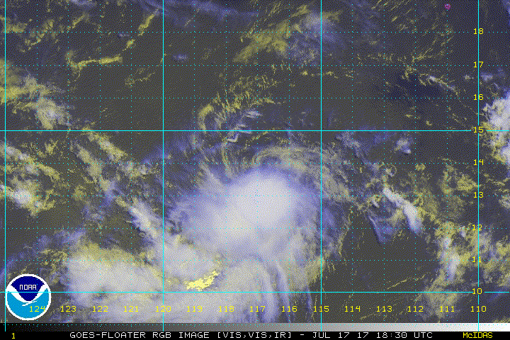
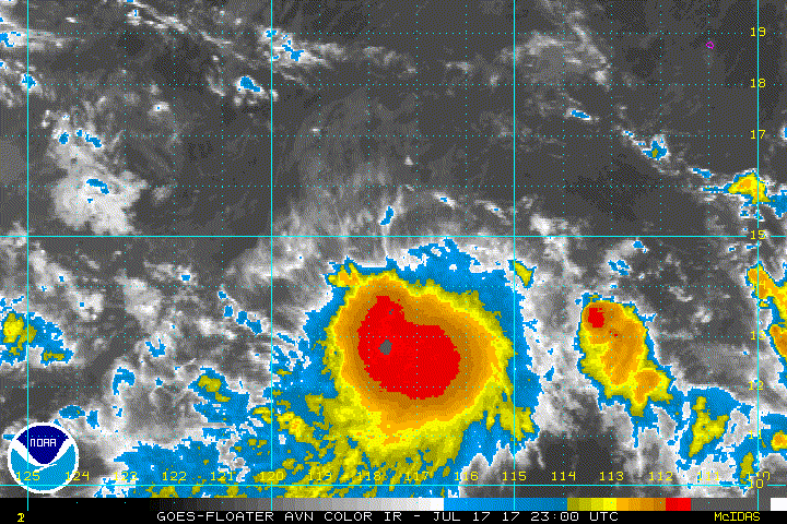
Satellite images indicate that showers and thunderstorms continue
to become better organized in association with a low pressure
system located about 750 miles southwest of the southern tip of
the Baja California. Although upper-level winds are currently only
marginally conducive for development, only a small increase in the
organization of this system could lead to the formation of a
tropical depression at any time. This disturbance is expected to
move slowly westward or west-southwestward during the next few
days.
* Formation chance through 48 hours...high...70 percent.
* Formation chance through 5 days...high...70 percent.
0 likes
-
Yellow Evan
- Professional-Met
- Posts: 15951
- Age: 25
- Joined: Fri Jul 15, 2011 12:48 pm
- Location: Henderson, Nevada/Honolulu, HI
- Contact:
Re: EPAC: INVEST 98E
* EAST PACIFIC SHIPS INTENSITY FORECAST *
* IR SAT DATA AVAILABLE, OHC AVAILABLE *
* INVEST EP982017 07/18/17 06 UTC *
TIME (HR) 0 6 12 18 24 36 48 60 72 84 96 108 120
V (KT) NO LAND 30 31 30 30 30 27 27 29 31 32 35 38 41
V (KT) LAND 30 31 30 30 30 27 27 29 31 32 35 38 41
V (KT) LGEM 30 31 31 30 28 25 21 19 17 17 18 20 23
Storm Type TROP TROP TROP TROP TROP TROP TROP TROP TROP TROP TROP TROP TROP
SHEAR (KT) 21 22 27 28 28 28 16 4 13 11 10 8 12
SHEAR ADJ (KT) 7 4 0 -1 -2 -5 -1 5 -2 -8 -8 -5 -5
SHEAR DIR 311 306 300 291 296 293 289 285 159 149 122 109 108
SST (C) 28.2 28.1 28.0 27.9 27.7 27.5 27.6 27.9 28.3 28.7 28.8 28.9 28.9
POT. INT. (KT) 144 144 143 142 140 138 139 142 147 150 149 150 151
200 MB T (C) -53.3 -53.6 -53.5 -53.2 -53.2 -53.4 -53.1 -53.4 -53.2 -53.6 -53.5 -53.7 -53.4
200 MB VXT (C) -0.1 -0.1 -0.1 -0.3 -0.4 -0.5 -0.4 -0.2 0.0 0.0 0.0 0.0 0.0
TH_E DEV (C) 5 5 5 5 5 5 5 5 5 5 6 6 6
700-500 MB RH 65 66 64 65 65 67 70 72 70 63 61 59 59
MODEL VTX (KT) 8 7 7 7 7 7 8 9 LOST LOST LOST LOST LOST
850 MB ENV VOR -43 -35 -27 -23 -25 -23 -9 12 36 51 53 49 43
200 MB DIV 40 28 26 25 29 32 47 17 8 -7 6 21 5
700-850 TADV -5 0 1 0 0 0 3 1 5 2 1 0 0
LAND (KM) 1222 1232 1259 1296 1338 1430 1547 1700 1888 2055 2141 2186 2198
LAT (DEG N) 14.5 14.8 15.0 15.1 15.1 15.1 14.8 14.1 12.7 11.3 10.7 10.6 11.1
LONG(DEG W) 117.5 118.0 118.6 119.2 119.9 121.3 122.6 123.9 124.9 125.6 126.1 126.6 127.3
STM SPEED (KT) 6 6 6 6 6 7 7 8 9 6 3 3 5
HEAT CONTENT 25 25 22 20 19 12 8 11 32 52 53 52 39
FORECAST TRACK FROM TABM INITIAL HEADING/SPEED (DEG/KT):315/ 5 CX,CY: -3/ 4
T-12 MAX WIND: 25 PRESSURE OF STEERING LEVEL (MB): 733 (MEAN=550)
GOES IR BRIGHTNESS TEMP. STD DEV. 50-200 KM RAD: 26.8 (MEAN=14.5)
% GOES IR PIXELS WITH T < -20 C 50-200 KM RAD: 55.0 (MEAN=65.0)
PRELIM RI PROB (DV .GE. 55 KT IN 48 HR): 0.0
INDIVIDUAL CONTRIBUTIONS TO INTENSITY CHANGE
6 12 18 24 36 48 60 72 84 96 108 120
----------------------------------------------------------
SAMPLE MEAN CHANGE 0. 0. 1. 1. 1. 1. 1. 1. -0. -1. -1. -2.
SST POTENTIAL 0. 1. 2. 3. 7. 12. 17. 22. 25. 27. 28. 27.
VERTICAL SHEAR MAG 0. 0. -1. -2. -6. -9. -10. -12. -12. -12. -10. -8.
VERTICAL SHEAR ADJ -0. -1. -1. -0. -0. 0. -0. -0. 0. 0. 0. 0.
VERTICAL SHEAR DIR -0. -1. -2. -3. -5. -7. -9. -9. -9. -8. -7. -5.
PERSISTENCE 1. 2. 2. 2. 2. 2. 2. 1. 1. 1. 1. 0.
200/250 MB TEMP. 0. 0. 0. 0. 0. -0. -1. -3. -3. -3. -3. -3.
THETA_E EXCESS -0. -0. -0. -1. -1. -1. -2. -2. -2. -3. -3. -3.
700-500 MB RH 0. 0. 0. 0. 0. 0. 1. 1. 1. 2. 2. 2.
MODEL VTX TENDENCY -0. -0. -0. -0. -1. 0. 2. 2. 2. 2. 2. 1.
850 MB ENV VORTICITY 0. 0. 0. 0. 0. 1. 1. 1. 1. 1. 1. 1.
200 MB DIVERGENCE -0. -0. -0. -0. -1. -0. -1. -1. -1. -1. -1. -1.
850-700 T ADVEC -0. -0. 0. -0. 0. 0. 0. 0. 1. 1. 1. 1.
ZONAL STORM MOTION -0. -0. -1. -1. -1. -2. -2. -2. -1. -1. -1. -1.
STEERING LEVEL PRES 0. 1. 2. 2. 3. 4. 4. 4. 4. 5. 4. 4.
DAYS FROM CLIM. PEAK -0. -0. -0. -0. 0. -0. -0. -0. -1. -1. -1. -1.
GOES PREDICTORS -1. -1. -1. -2. -2. -3. -3. -3. -3. -2. -3. -3.
OCEAN HEAT CONTENT 0. 0. 0. 0. 0. -0. -0. -0. 0. 0. 0. -0.
----------------------------------------------------------
TOTAL CHANGE 1. 0. 0. -0. -3. -2. -1. 1. 2. 5. 8. 11.
CURRENT MAX WIND (KT): 30. LAT, LON: 14.5 117.5
** 2017 E.PACIFIC RI INDEX EP982017 INVEST 07/18/17 06 UTC **
(SHIPS-RII PREDICTOR TABLE for 30 KT OR MORE MAXIMUM WIND INCREASE IN NEXT 24-h)
Predictor Value RI Predictor Range Scaled Value(0-1) % Contribution
12 HR PERSISTENCE (KT): 5.0 -22.0 to 44.0 0.41 999.0
POT = MPI-VMAX (KT) : 112.3 40.5 to 149.3 0.66 999.0
850-200 MB SHEAR (KT) : 25.2 18.9 to 1.4 0.00 0.0
HEAT CONTENT (KJ/cm2) : 22.2 0.0 to 106.7 0.21 999.0
MAXIMUM WIND (kt) : 30.0 22.5 to 132.0 0.21 999.0
D200 (10**7s-1) : 29.6 -33.0 to 156.2 0.33 999.0
STD DEV OF IR BR TEMP : 26.8 37.8 to 2.1 0.31 999.0
% AREA WITH TPW <45 mm: 1.5 62.3 to 0.0 0.98 999.0
2nd PC OF IR BR TEMP : 1.7 2.2 to -1.9 0.12 999.0
BL DRY-AIR FLUX (w/m2): 130.0 735.9 to -82.5 0.74 999.0
SHIPS Prob RI for 20kt/ 12hr RI threshold= 2% is 0.2 times sample mean ( 7.7%)
SHIPS Prob RI for 25kt/ 24hr RI threshold= 0% is 0.0 times sample mean (15.3%)
SHIPS Prob RI for 30kt/ 24hr RI threshold= 0% is 0.0 times sample mean (10.4%)
SHIPS Prob RI for 35kt/ 24hr RI threshold= 0% is 0.0 times sample mean ( 7.5%)
SHIPS Prob RI for 40kt/ 24hr RI threshold= 0% is 0.0 times sample mean ( 5.2%)
SHIPS Prob RI for 45kt/ 36hr RI threshold= 0% is 0.0 times sample mean ( 8.1%)
SHIPS Prob RI for 55kt/ 48hr RI threshold= 0% is 0.0 times sample mean ( 7.4%)
SHIPS Prob RI for 65kt/ 72hr RI threshold= 0% is 0.0 times sample mean ( 5.5%)
Matrix of RI probabilities
------------------------------------------------------------------------------
RI (kt / h) | 20/12 | 25/24 | 30/24 | 35/24 | 40/24 | 45/36 | 55/48 |65/72
------------------------------------------------------------------------------
SHIPS-RII: 1.9% 0.0% 0.0% 0.0% 0.0% 0.0% 0.0% 0.0%
Logistic: 0.1% 0.1% 0.0% 0.0% 0.0% 0.0% 0.0% 0.2%
Bayesian: 0.0% 0.0% 0.0% 0.0% 0.0% 0.0% 0.0% 0.0%
Consensus: 0.7% 0.0% 0.0% 0.0% 0.0% 0.0% 0.0% 0.1%
## ANNULAR HURRICANE INDEX (AHI) EP982017 INVEST 07/18/17 06 UTC ##
## STORM NOT ANNULAR, SCREENING STEP FAILED, NPASS=3 NFAIL=4 ##
## AHI= 0 (AHI OF 100 IS BEST FIT TO ANN. STRUC., 1 IS MARGINAL, 0 IS NOT ANNULAR) ##
0 likes
-
Yellow Evan
- Professional-Met
- Posts: 15951
- Age: 25
- Joined: Fri Jul 15, 2011 12:48 pm
- Location: Henderson, Nevada/Honolulu, HI
- Contact:
-
Sciencerocks
- Category 5
- Posts: 7282
- Age: 38
- Joined: Thu Jul 06, 2017 1:51 am
-
cycloneye

- Admin

- Posts: 139026
- Age: 67
- Joined: Thu Oct 10, 2002 10:54 am
- Location: San Juan, Puerto Rico
Re: EPAC: INVEST 98E
Satellite images indicate that organized showers and thunderstorms
continue in association with a low pressure system located about 800
miles southwest of the southern tip of Baja California. Although
upper-level winds are currently only marginally conducive for
development, only a small increase in the organization of this
system could lead to the formation of a tropical depression at any
time. This disturbance is expected to move slowly westward or
west-southwestward during the next few days.
* Formation chance through 48 hours...high...80 percent.
* Formation chance through 5 days...high...80 percent.
0 likes
Visit the Caribbean-Central America Weather Thread where you can find at first post web cams,radars
and observations from Caribbean basin members Click Here
and observations from Caribbean basin members Click Here

Re: EPAC: INVEST 98E
08E EIGHT 170718 1200 14.6N 118.6W EPAC 30 1007
We have 08E.
We have 08E.
0 likes
Remember, all of my post aren't official. For official warnings and discussions, Please refer to your local NWS products...
NWS for the Western Pacific
https://www.weather.gov/gum/
NWS for the Western Pacific
https://www.weather.gov/gum/
-
Yellow Evan
- Professional-Met
- Posts: 15951
- Age: 25
- Joined: Fri Jul 15, 2011 12:48 pm
- Location: Henderson, Nevada/Honolulu, HI
- Contact:
Re: EPAC: INVEST 98E
* EAST PACIFIC SHIPS INTENSITY FORECAST *
* IR SAT DATA AVAILABLE, OHC AVAILABLE *
* INVEST EP982017 07/18/17 12 UTC *
TIME (HR) 0 6 12 18 24 36 48 60 72 84 96 108 120
V (KT) NO LAND 30 31 31 31 30 29 32 36 37 37 38 38 38
V (KT) LAND 30 31 31 31 30 29 32 36 37 37 38 38 38
V (KT) LGEM 30 31 31 30 29 25 23 22 22 24 26 27 27
Storm Type TROP TROP TROP TROP TROP TROP TROP TROP TROP TROP TROP TROP TROP
SHEAR (KT) 23 29 30 30 28 20 8 11 15 9 11 9 11
SHEAR ADJ (KT) 4 1 -2 -2 -1 -4 -1 -2 -6 -4 -2 -4 -6
SHEAR DIR 310 304 301 307 304 304 339 118 155 168 194 188 195
SST (C) 28.1 28.0 27.9 27.9 27.8 27.9 28.0 28.1 28.2 28.2 27.7 27.2 27.3
POT. INT. (KT) 144 142 141 142 141 141 142 142 144 145 141 136 138
200 MB T (C) -53.7 -53.6 -53.2 -53.2 -53.4 -53.0 -53.4 -53.4 -53.7 -53.4 -53.7 -53.5 -53.6
200 MB VXT (C) -0.2 -0.3 -0.4 -0.5 -0.5 -0.6 -0.2 0.0 0.0 0.0 0.0 0.0 0.0
TH_E DEV (C) 5 6 6 6 6 6 6 6 6 6 5 5 6
700-500 MB RH 64 64 66 66 70 74 74 72 68 61 59 54 53
MODEL VTX (KT) 7 6 7 7 6 7 8 LOST LOST LOST LOST LOST LOST
850 MB ENV VOR -55 -54 -46 -44 -41 -17 12 28 48 49 43 42 46
200 MB DIV 20 9 18 15 31 46 14 11 0 12 25 21 11
700-850 TADV 0 0 0 0 0 0 1 3 2 0 0 2 2
LAND (KM) 1292 1329 1363 1422 1482 1594 1700 1791 1847 1839 1815 1931 2151
LAT (DEG N) 14.6 xx.x xx.x xx.x xx.x xx.x xx.x xx.x xx.x xx.x xx.x xx.x xx.x
LONG(DEG W) 118.6 xxx.x xxx.x xxx.x xxx.x xxx.x xxx.x xxx.x xxx.x xxx.x xxx.x xxx.x xxx.x
STM SPEED (KT) 7 5 5 6 6 5 5 4 5 8 9 10 11
HEAT CONTENT 20 21 22 26 25 18 17 24 27 18 14 3 1
FORECAST TRACK FROM OFPI INITIAL HEADING/SPEED (DEG/KT):295/ 7 CX,CY: -5/ 3
T-12 MAX WIND: 25 PRESSURE OF STEERING LEVEL (MB): 706 (MEAN=550)
GOES IR BRIGHTNESS TEMP. STD DEV. 50-200 KM RAD: 25.8 (MEAN=14.5)
% GOES IR PIXELS WITH T < -20 C 50-200 KM RAD: 58.0 (MEAN=65.0)
PRELIM RI PROB (DV .GE. 55 KT IN 48 HR): 0.0
INDIVIDUAL CONTRIBUTIONS TO INTENSITY CHANGE
6 12 18 24 36 48 60 72 84 96 108 120
----------------------------------------------------------
SAMPLE MEAN CHANGE 0. 0. 1. 1. 1. 1. 1. 1. -0. -1. -1. -2.
SST POTENTIAL 0. 1. 2. 3. 7. 12. 18. 22. 25. 27. 27. 26.
VERTICAL SHEAR MAG 0. -0. -1. -3. -7. -9. -10. -11. -12. -11. -9. -7.
VERTICAL SHEAR ADJ -0. -0. -0. -0. 0. 1. 0. 0. 0. 0. 0. 0.
VERTICAL SHEAR DIR -0. -1. -2. -3. -5. -6. -5. -5. -6. -7. -8. -8.
PERSISTENCE 1. 2. 2. 2. 2. 2. 2. 1. 1. 1. 1. 0.
200/250 MB TEMP. 0. 0. 0. 0. 0. -1. -2. -4. -4. -4. -4. -4.
THETA_E EXCESS -0. -0. -0. -0. -0. -1. -1. -1. -1. -2. -2. -2.
700-500 MB RH 0. 0. 0. 0. 0. 1. 1. 1. 2. 2. 2. 2.
MODEL VTX TENDENCY -0. 0. 0. -0. 0. 2. 3. 3. 2. 2. 2. 2.
850 MB ENV VORTICITY 0. 0. 0. 0. 0. 1. 1. 1. 1. 1. 1. 1.
200 MB DIVERGENCE -0. -0. -1. -1. -1. -1. -1. -2. -2. -2. -1. -1.
850-700 T ADVEC 0. 0. -0. -0. 0. 0. 0. 0. 1. 1. 1. 1.
ZONAL STORM MOTION -0. -0. -0. -0. -0. -1. -1. -1. -1. -0. -0. -1.
STEERING LEVEL PRES 0. 1. 1. 2. 3. 3. 3. 4. 4. 4. 4. 4.
DAYS FROM CLIM. PEAK -0. -0. -0. -0. 0. -0. -0. -0. -1. -1. -1. -1.
GOES PREDICTORS -0. -1. -1. -1. -2. -2. -3. -3. -3. -2. -2. -2.
OCEAN HEAT CONTENT 0. 0. 0. 0. 0. 0. 0. 0. 0. 0. 0. -0.
----------------------------------------------------------
TOTAL CHANGE 1. 1. 1. -0. -1. 2. 6. 7. 7. 8. 8. 8.
CURRENT MAX WIND (KT): 30. LAT, LON: 14.6 118.6
** 2017 E.PACIFIC RI INDEX EP982017 INVEST 07/18/17 12 UTC **
(SHIPS-RII PREDICTOR TABLE for 30 KT OR MORE MAXIMUM WIND INCREASE IN NEXT 24-h)
Predictor Value RI Predictor Range Scaled Value(0-1) % Contribution
12 HR PERSISTENCE (KT): 5.0 -22.0 to 44.0 0.41 999.0
POT = MPI-VMAX (KT) : 111.9 40.5 to 149.3 0.66 999.0
850-200 MB SHEAR (KT) : 27.9 18.9 to 1.4 0.00 0.0
HEAT CONTENT (KJ/cm2) : 22.8 0.0 to 106.7 0.21 999.0
MAXIMUM WIND (kt) : 30.0 22.5 to 132.0 0.21 999.0
D200 (10**7s-1) : 18.6 -33.0 to 156.2 0.27 999.0
STD DEV OF IR BR TEMP : 25.8 37.8 to 2.1 0.34 999.0
% AREA WITH TPW <45 mm: 8.8 62.3 to 0.0 0.86 999.0
2nd PC OF IR BR TEMP : 1.0 2.2 to -1.9 0.30 999.0
BL DRY-AIR FLUX (w/m2): 127.8 735.9 to -82.5 0.74 999.0
SHIPS Prob RI for 20kt/ 12hr RI threshold= 0% is 0.0 times sample mean ( 7.7%)
SHIPS Prob RI for 25kt/ 24hr RI threshold= 0% is 0.0 times sample mean (15.3%)
SHIPS Prob RI for 30kt/ 24hr RI threshold= 0% is 0.0 times sample mean (10.4%)
SHIPS Prob RI for 35kt/ 24hr RI threshold= 0% is 0.0 times sample mean ( 7.5%)
SHIPS Prob RI for 40kt/ 24hr RI threshold= 0% is 0.0 times sample mean ( 5.2%)
SHIPS Prob RI for 45kt/ 36hr RI threshold= 0% is 0.0 times sample mean ( 8.1%)
SHIPS Prob RI for 55kt/ 48hr RI threshold= 0% is 0.0 times sample mean ( 7.4%)
SHIPS Prob RI for 65kt/ 72hr RI threshold= 0% is 0.0 times sample mean ( 5.5%)
Matrix of RI probabilities
------------------------------------------------------------------------------
RI (kt / h) | 20/12 | 25/24 | 30/24 | 35/24 | 40/24 | 45/36 | 55/48 |65/72
------------------------------------------------------------------------------
SHIPS-RII: 0.0% 0.0% 0.0% 0.0% 0.0% 0.0% 0.0% 0.0%
Logistic: 0.1% 0.1% 0.0% 0.0% 0.0% 0.0% 0.0% 0.3%
Bayesian: 0.0% 0.0% 0.0% 0.0% 0.0% 0.0% 0.0% 0.0%
Consensus: 0.0% 0.0% 0.0% 0.0% 0.0% 0.0% 0.0% 0.1%
## ANNULAR HURRICANE INDEX (AHI) EP982017 INVEST 07/18/17 12 UTC ##
## STORM NOT ANNULAR, SCREENING STEP FAILED, NPASS=3 NFAIL=4 ##
## AHI= 0 (AHI OF 100 IS BEST FIT TO ANN. STRUC., 1 IS MARGINAL, 0 IS NOT ANNULAR) ##
0 likes
-
cycloneye
- Admin
- Posts: 139026
- Age: 67
- Joined: Thu Oct 10, 2002 10:54 am
- Location: San Juan, Puerto Rico
Re: EPAC: EIGHT-E - Tropical Depression
Tropical Depression Eight-E Discussion Number 1
NWS National Hurricane Center Miami FL EP082017
800 AM PDT Tue Jul 18 2017
Deep convection associated with the area of low pressure located
well southwest of the Baja California peninsula developed closer to
the system's center overnight. It has also produced convection for
more than 24 hours despite strong northwesterly shear. Based on the
recent slight improvement in organization, and Dvorak T-numbers of
2.0 and 2.5 from SAB and TAFB, advisories are initiated on a 30-kt
tropical depression.
A large upper-level low centered to its north-northwest is currently
imparting about 25-30 kt of shear over the system. The shear is not
expected to lessen during the next day or two, and only slight
strengthening is indicated in the official forecast during that
time. After 72 hours, the upper-level wind pattern could become
less hostile which could allow for some strengthening if the
tropical cyclone survives the shear over the next couple of days.
The latter portion of the intensity forecast is of low confidence.
The depression has been moving slowly westward or west-
northwestward, but is expected to begin a slow southwestward motion
later today, which is due in part to the circulation of Tropical
Storm Greg to its east. Later in the forecast period, as Greg passes
to its north, the tropical cyclone should begin to move west-
northwestward at a faster forward speed. An alternative
scenario shown by the GFS and UKMET models is for the depression to
weaken and be absorbed by the circulation of Greg in a few days.
Given the possible interaction of Greg, the confidence in the
track forecast is also quite low.
FORECAST POSITIONS AND MAX WINDS
INIT 18/1500Z 14.6N 118.8W 30 KT 35 MPH
12H 19/0000Z 14.6N 119.5W 35 KT 40 MPH
24H 19/1200Z 14.3N 120.3W 35 KT 40 MPH
36H 20/0000Z 13.8N 121.2W 35 KT 40 MPH
48H 20/1200Z 13.4N 121.9W 35 KT 40 MPH
72H 21/1200Z 13.0N 123.0W 40 KT 45 MPH
96H 22/1200Z 13.3N 126.0W 40 KT 45 MPH
120H 23/1200Z 14.0N 130.0W 40 KT 45 MPH
$$
Forecaster Brown
0 likes
Visit the Caribbean-Central America Weather Thread where you can find at first post web cams,radars
and observations from Caribbean basin members Click Here
and observations from Caribbean basin members Click Here
-
Yellow Evan
- Professional-Met
- Posts: 15951
- Age: 25
- Joined: Fri Jul 15, 2011 12:48 pm
- Location: Henderson, Nevada/Honolulu, HI
- Contact:
Re: EPAC: EIGHT-E - Tropical Depression
18/1200 UTC 15.0N 118.3W T2.5/2.5 98E -- East Pacific
0 likes
Re: EPAC: EIGHT-E - Tropical Depression
ATCF Best Track
System ID: EP08 (EIGHT)
0000 UTC Jul 19, 2017
Location: 14.9°N, 119.7°W
Central Pressure: 1007 mb
Maximum Winds (1-min): 30 kt (34 mph)
Type: Tropical Depression (TD)
System ID: EP08 (EIGHT)
0000 UTC Jul 19, 2017
Location: 14.9°N, 119.7°W
Central Pressure: 1007 mb
Maximum Winds (1-min): 30 kt (34 mph)
Type: Tropical Depression (TD)
Shear is still very strong.

0 likes
Who is online
Users browsing this forum: LemieT and 48 guests