

EPAC: IRWIN - Post-Tropical
Moderator: S2k Moderators
Re: EPAC: IRWIN - Hurricane
Will be interesting if the superimposed CCKW just arriving will help
0 likes
The above post and any post by Ntxw is NOT an official forecast and should not be used as such. It is just the opinion of the poster and may or may not be backed by sound meteorological data. It is NOT endorsed by any professional institution including Storm2k. For official information, please refer to NWS products.
Help support Storm2K!

-
Yellow Evan

- Professional-Met

- Posts: 15951
- Age: 25
- Joined: Fri Jul 15, 2011 12:48 pm
- Location: Henderson, Nevada/Honolulu, HI
- Contact:
Re: EPAC: IRWIN - Hurricane
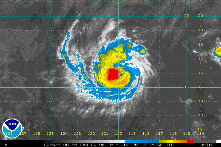
TXPZ23 KNES 260028
TCSENP
A. 10E (IRWIN)
B. 26/0000Z
C. 16.0N
D. 120.5W
E. ONE/GOES-W
F. T4.5/4.5/D1.0/24HRS
G. IR/EIR/VIS
H. REMARKS...EYE PATTERN WITH AN OW EYE SURROUNDED BY B AND EMBEDDED IN
LG. THIS RESULTS IN A DT OF 5.0 WITH NO EYE ADJUSTMENTS. MET IS 4.0 BASED
ON DEVELOPMENT OVER THE LAST 24-HOURS AND PT IS ADJUSTED UP TO 5.0. FT
IS BASED ON CONSTRAINTS LIMITING CHANGES GREATER THAN 1.0 IN 6-HOURS.
I. ADDL POSITIONS
NIL
...WHISNANT
0 likes
-
Sciencerocks
- Category 5

- Posts: 7282
- Age: 38
- Joined: Thu Jul 06, 2017 1:51 am
-
Sciencerocks
- Category 5
- Posts: 7282
- Age: 38
- Joined: Thu Jul 06, 2017 1:51 am
Re: EPAC: IRWIN - Hurricane
000
WTPZ45 KNHC 260256
TCDEP5
Hurricane Irwin Discussion Number 15
NWS National Hurricane Center Miami FL EP102017
800 PM PDT Tue Jul 25 2017
Irwin has strengthened a little more during the past several hours.
The eye of the hurricane has been occasionally evident in
satellite images and cloud tops in the eyewall are quite cold,
close to -80 C. The convective structure is asymmetric, however,
with the majority of the deepest convection located to the west of
the center. The latest Dvorak classifications have increased
slightly, and support nudging the initial intensity upward to 80 kt.
Irwin is moving westward at 7 kt as it is still being steered by a
mid-level ridge to its northeast. A turn to the west-southwest is
expected tonight and Wednesday as Hurricane Hilary approaches from
the east. The forward motion of Irwin will likely come to a halt on
Thursday and Friday as Hilary passes by to the north. After that
time, a general northward motion is expected as Irwin gets caught in
the flow on the east side of Hilary's circulation. The models are
in better agreement compared to previous cycles, but there is still
a fair amount of spread in where and when Irwin makes the northward
turn. The NHC track forecast is largely an update of the previous
one, and lies closest to the multi-model consensus TVCE.
The hurricane could be nearing its peak intensity, and weakening
should commence soon due to moderate wind shear and the potential
for cold water upwelling due to the expected slow motion of Irwin.
By the end of the forecast period, Irwin will be moving over much
cooler SSTs and into a drier air mass, which should continue the
weakening trend. The models are in good agreement, and the NHC
intensity forecast lies near the middle of the guidance envelope.
Irwin is a very compact hurricane. ASCAT data from around 1800 UTC
indicated that the tropical storm force winds extend no more than 60
n mi from the center.
FORECAST POSITIONS AND MAX WINDS
INIT 26/0300Z 16.1N 120.9W 80 KT 90 MPH
12H 26/1200Z 15.7N 121.9W 75 KT 85 MPH
24H 27/0000Z 15.2N 123.0W 70 KT 80 MPH
36H 27/1200Z 14.9N 123.8W 60 KT 70 MPH
48H 28/0000Z 14.7N 124.0W 55 KT 65 MPH
72H 29/0000Z 15.5N 123.5W 55 KT 65 MPH
96H 30/0000Z 18.2N 123.5W 55 KT 65 MPH
120H 31/0000Z 22.0N 126.0W 45 KT 50 MPH
$$
Forecaster Cangialosi
0 likes
-
Yellow Evan
- Professional-Met
- Posts: 15951
- Age: 25
- Joined: Fri Jul 15, 2011 12:48 pm
- Location: Henderson, Nevada/Honolulu, HI
- Contact:
Re: EPAC: IRWIN - Hurricane
Not sure this is a hurricane anymore. Seems to be decoupling - something that the global models did not catch.
0 likes
-
Sciencerocks
- Category 5
- Posts: 7282
- Age: 38
- Joined: Thu Jul 06, 2017 1:51 am

-
Sciencerocks
- Category 5
- Posts: 7282
- Age: 38
- Joined: Thu Jul 06, 2017 1:51 am
Re: EPAC: IRWIN - Hurricane
CZC MIATCDEP5 ALL
TTAA00 KNHC DDHHMM
Hurricane Irwin Discussion Number 16
NWS National Hurricane Center Miami FL EP102017
200 AM PDT Wed Jul 26 2017
An earlier 0500 UTC METOP-A AMSU image and fortuitous ASCAT
A/B overpasses indicate that Irwin's circulation center is located
near the southern edge of the cloud canopy. Apparently, the
moderate southeasterly outflow produced by Hurricane Hilary is
affecting Irwin's core structure. Cloud tops have warmed during
the past several hours and a compromise of the Dvorak subjective
T-numbers from SAB and TAFB support an initial intensity of 70 kt
for this advisory. The global models as well as the
statistical-dynamical intensity guidance show continued slow
weakening during the next 36 hours while the hurricane remains
within the impinging upper-level outflow of Hilary. Afterward,
further gradual weakening is forecast as the cyclone traverses
cooler oceanic temperatures and enters a less than favorable
thermodynamic environment. The official forecast is similar to the
previous package and is based on the IVCN consensus.
The much anticipated turn toward the west-southwest has finally
commenced, and the cyclone motion is estimated to be 255/6 kt.
Some binary interaction with Hilary during the next 48 hours or
so should cause Irwin to stall, and then accelerate cyclonically
around the southeast through northeast periphery of Hilary on days
4 and 5. Global and ensemble models, however, show a much slower
forward motion beyond 72 hours than what was indicated in the
previous advisory, and adjustments to the 96 and 120 hour forecast
periods have been made accordingly. The NHC forecast reflects this
significant change in the guidance and is based a blend of the TVCX
and HFIP Corrected Consensus (HCCA) models.
The ASCAT 0502 UTC scatterometer data and the RVCN multi-model
consensus were used for the initial and forecast wind radii.
FORECAST POSITIONS AND MAX WINDS
INIT 26/0900Z 15.7N 121.5W 70 KT 80 MPH
12H 26/1800Z 15.5N 122.5W 65 KT 75 MPH
24H 27/0600Z 15.1N 123.7W 60 KT 70 MPH
36H 27/1800Z 14.8N 124.4W 55 KT 65 MPH
48H 28/0600Z 14.7N 124.7W 55 KT 65 MPH
72H 29/0600Z 14.9N 124.5W 55 KT 65 MPH
96H 30/0600Z 18.0N 124.5W 50 KT 60 MPH
120H 31/0600Z 20.5N 126.0W 45 KT 50 MPH
$$
Forecaster Roberts
NNNN
0 likes
-
wxman57

- Moderator-Pro Met

- Posts: 22480
- Age: 66
- Joined: Sat Jun 21, 2003 8:06 pm
- Location: Houston, TX (southwest)
Re: EPAC: IRWIN - Hurricane
I'm sort of doubting that Irwin is a T4.5/70 kts (should be 77kts) hurricane (according to last NHC advisory). ASCAT pass at 5Z had one 40kt barb. Center is exposed south of dissipating convection. That doesn't equal Dvorak of 4.5.

0 likes
-
cycloneye

- Admin

- Posts: 139025
- Age: 67
- Joined: Thu Oct 10, 2002 10:54 am
- Location: San Juan, Puerto Rico
Re: EPAC: IRWIN - Tropical Storm
Tropical Storm Irwin Discussion Number 17
NWS National Hurricane Center Miami FL EP102017
800 AM PDT Wed Jul 26 2017
Satellite images and microwave data indicate that Irwin's cloud
pattern has significantly deteriorated since yesterday. It now
consists of a tight circulation center located just to the south of
an area of deep, but not too well organized, convection.
Consequently, the initial intensity has been decreased to 55 kt
based on lower Dvorak T-numbers from all agencies. The environment
does not support significant weakening, but is not favorable for
much intensification either. The NHC forecast calls for a slight
weakening today, and shows no change in intensity for the
next 5 days. Although the intensity forecast is a little bit
different from the previous one due to the lower current intensity,
it does not change the general trend expressed in previous NHC
forecasts.
Irwin is moving toward the west-southwest or 255 degrees at 6 kt.
Currently, the cyclone is embedded within weak steering currents,
and Irwin will probably continue on the same slow west-southwest
track during the next day or two. After that time, Hurricane Hilary
is forecast to pass well north of Irwin, and the steering currents
will change to southerlies, and most of the models agree that Irwin
should begin to move with a northerly component in the wake of
Hilary. This is reflected in the official NHC forecast which in fact
is close to the multi-model consensus TVCN, and is not very
different from the previous one.
FORECAST POSITIONS AND MAX WINDS
INIT 26/1500Z 15.6N 122.1W 55 KT 65 MPH
12H 27/0000Z 15.3N 123.0W 45 KT 50 MPH
24H 27/1200Z 14.9N 124.1W 45 KT 50 MPH
36H 28/0000Z 14.5N 125.0W 45 KT 50 MPH
48H 28/1200Z 14.5N 125.5W 45 KT 50 MPH
72H 29/1200Z 15.0N 125.0W 45 KT 50 MPH
96H 30/1200Z 17.5N 125.0W 45 KT 50 MPH
120H 31/1200Z 20.5N 126.0W 45 KT 50 MPH
$$
Forecaster Avila
0 likes
Visit the Caribbean-Central America Weather Thread where you can find at first post web cams,radars
and observations from Caribbean basin members Click Here
and observations from Caribbean basin members Click Here
-
wxman57
- Moderator-Pro Met
- Posts: 22480
- Age: 66
- Joined: Sat Jun 21, 2003 8:06 pm
- Location: Houston, TX (southwest)
Re: EPAC: IRWIN - Tropical Storm
Good ASCAT hit at 1732Z. I see a number of 35kt winds but none higher.
1 likes
-
Kingarabian

- S2K Supporter

- Posts: 15432
- Joined: Sat Aug 08, 2009 3:06 am
- Location: Honolulu, Hawaii
Re: EPAC: IRWIN - Tropical Storm
Irwin is eating Hilary, which is different than what the models are showing. Interesting.
0 likes
RIP Kobe Bryant
Re: EPAC: IRWIN - Tropical Storm
Kingarabian wrote:Irwin is eating Hilary, which is different than what the models are showing. Interesting.
That seems to be the case this morning, as he is larger in size than she is.
0 likes
The above post and any post by Ntxw is NOT an official forecast and should not be used as such. It is just the opinion of the poster and may or may not be backed by sound meteorological data. It is NOT endorsed by any professional institution including Storm2k. For official information, please refer to NWS products.
Help support Storm2K!
Help support Storm2K!
-
Sciencerocks
- Category 5
- Posts: 7282
- Age: 38
- Joined: Thu Jul 06, 2017 1:51 am
-
Sciencerocks
- Category 5
- Posts: 7282
- Age: 38
- Joined: Thu Jul 06, 2017 1:51 am
Re: EPAC: IRWIN - Tropical Storm
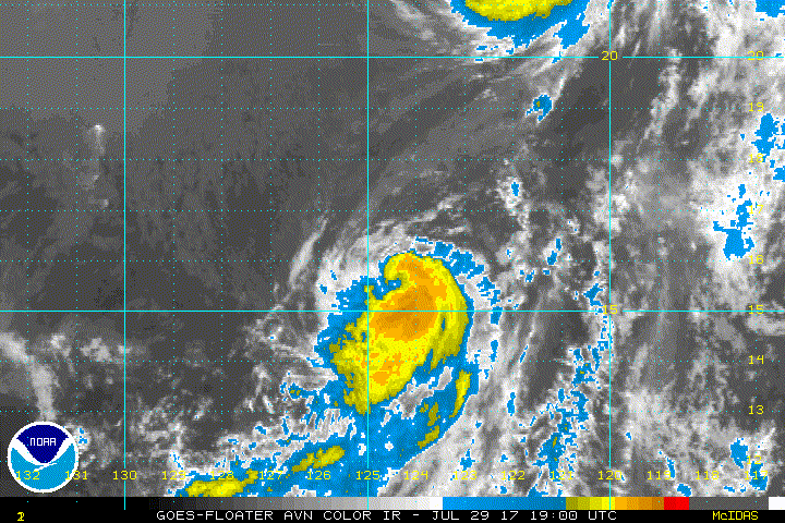
000
WTPZ45 KNHC 300232
TCDEP5
Tropical Storm Irwin Discussion Number 31
NWS National Hurricane Center Miami FL EP102017
800 PM PDT Sat Jul 29 2017
Irwin had a partially cloud-free region near its center in visible
satellite imagery a few hours ago, but that feature has since
filled, and cloud-top temperatures have cooled in the central
region. Satellite intensity estimates range widely from 35 kt to
55 kt, but an ASCAT pass from around 1800 UTC showed maximum winds
just over 40 kt in the southeastern quadrant. Based on that data,
the initial intensity is lowered to 45 kt. Although the shear over
the cyclone is low and should remain low for several days, Irwin
only has another 12 hours or so before it reaches waters colder than
26 deg C. Therefore, additional weakening is anticipated after 12
hours, and Irwin could degenerate into a remnant low as early as 48
hours while it is over sea surface temperatures of 22 deg C. Based
on a consensus of the global models, the remnant low should
dissipate by day 5.
Irwin is accelerating toward the north as anticipated, and the
initial motion is now 355/7 kt. The cyclone should turn
north-northwestward soon and continue accelerating during the next
36 hours in the wake of Tropical Storm Hilary. After 48 hours,
once the two remnant circulations get even closer together, Irwin
is likely to turn northwestward and slow down considerably. There
is a normal amount of spread among the track guidance, and the
updated NHC track forecast was only shifted slightly northeast of
the previous forecast on days 3 and 4 to lean closer to the ECMWF,
HCCA, and the various multi-model consensus aids.
FORECAST POSITIONS AND MAX WINDS
INIT 30/0300Z 16.4N 124.6W 45 KT 50 MPH
12H 30/1200Z 17.7N 125.0W 45 KT 50 MPH
24H 31/0000Z 19.9N 126.0W 40 KT 45 MPH
36H 31/1200Z 22.3N 127.4W 35 KT 40 MPH
48H 01/0000Z 24.6N 128.9W 25 KT 30 MPH...POST-TROP/REMNT LOW
72H 02/0000Z 27.4N 132.1W 20 KT 25 MPH...POST-TROP/REMNT LOW
96H 03/0000Z 28.5N 133.5W 15 KT 15 MPH...POST-TROP/REMNT LOW
120H 04/0000Z...DISSIPATED
$$
Forecaster Berg
0 likes
-
cycloneye
- Admin
- Posts: 139025
- Age: 67
- Joined: Thu Oct 10, 2002 10:54 am
- Location: San Juan, Puerto Rico
Re: EPAC: IRWIN - Tropical Storm
Tropical Storm Irwin Discussion Number 35
NWS National Hurricane Center Miami FL EP102017
800 PM PDT Sun Jul 30 2017
Irwin is one resilient tropical storm. Amazingly, the cloud
pattern has improved during the past few hours, with deep
convection forming and rotating around the center even though the
cyclone is now over sea surface temperatures colder than 25 deg C.
A 0002 UTC SSMIS microwave pass revealed a small ring of deep
convection that was partially open on the east side, but it also
suggested that the vortex is tilted a bit with height. Since Dvorak
estimates from TAFB and SAB are a consensus T3.5, the initial
intensity remains 55 kt.
Irwin will be moving from 24-25C waters to 22-23C waters during the
next 24 hours, so weakening should begin soon. In fact, it will be
quite difficult for Irwin to continue producing organized deep
convection in about 36 hours, and that is when the NHC forecast
calls for it to degenerate into a remnant low. Based on global
model fields, the remnant low is forecast to dissipate by day 4, if
not sooner. No changes to the previous NHC forecast were required
based on the latest intensity guidance.
The forward motion continues to increase as Irwin trails behind
Hilary, and the current estimate is 335/11 kt. A little more
acceleration toward the north-northwest is expected during the next
12-24 hours, but Irwin should turn northwest and slow down on days
2 and 3 as it moves around the remnant circulation of Hilary. The
updated NHC track forecast was nudged northeast of the previous
forecast after 24 hours to be closer in line with the latest HCCA
and TVCN guidance, but otherwise no significant changes were needed.
FORECAST POSITIONS AND MAX WINDS
INIT 31/0300Z 19.8N 126.2W 55 KT 65 MPH
12H 31/1200Z 21.5N 127.1W 50 KT 60 MPH
24H 01/0000Z 23.9N 128.2W 40 KT 45 MPH
36H 01/1200Z 26.0N 129.6W 30 KT 35 MPH...POST-TROP/REMNT LOW
48H 02/0000Z 27.6N 131.1W 25 KT 30 MPH...POST-TROP/REMNT LOW
72H 03/0000Z 28.9N 133.0W 20 KT 25 MPH...POST-TROP/REMNT LOW
96H 04/0000Z...DISSIPATED
$$
Forecaster Berg
0 likes
Visit the Caribbean-Central America Weather Thread where you can find at first post web cams,radars
and observations from Caribbean basin members Click Here
and observations from Caribbean basin members Click Here
-
Hurricaneman

- Category 5
- Posts: 7280
- Age: 43
- Joined: Tue Aug 31, 2004 3:24 pm
- Location: central florida
-
cycloneye
- Admin
- Posts: 139025
- Age: 67
- Joined: Thu Oct 10, 2002 10:54 am
- Location: San Juan, Puerto Rico
Re: EPAC: IRWIN - Tropical Storm
Tropical Storm Irwin Discussion Number 39
NWS National Hurricane Center Miami FL EP102017
800 PM PDT Mon Jul 31 2017
Irwin isn't quite dead yet, with a new burst of convection in the
eastern semicircle, despite the storm being over sub-23C waters.
Intensity estimates are unchanged, so the winds are kept at 40 kt.
This burst should be short lived, and Irwin is forecast to lose all
remaining deep convection tomorrow over sub-22C waters. The cyclone
is expected to gradually spin down, and ultimately dissipate in 2 to
3 days. The NHC intensity forecast remains the same as the last
advisory, following the model consensus.
Irwin continues to move north-northwestward on the west side of a
mid-level high following behind the remnants of Hilary. This motion
is expected to continue for about another day, with Irwin predicted
to turn northwestward and slow down as the cyclone becomes shallow.
There is no significant change to the guidance, and the official
forecast is very close to the previous one.
FORECAST POSITIONS AND MAX WINDS
INIT 01/0300Z 23.8N 128.3W 40 KT 45 MPH
12H 01/1200Z 25.3N 129.2W 35 KT 40 MPH
24H 02/0000Z 26.8N 130.4W 30 KT 35 MPH...POST-TROP/REMNT LOW
36H 02/1200Z 28.0N 131.6W 25 KT 30 MPH...POST-TROP/REMNT LOW
48H 03/0000Z 29.1N 132.7W 20 KT 25 MPH...POST-TROP/REMNT LOW
72H 04/0000Z...DISSIPATED
$$
Forecaster Blake
0 likes
Visit the Caribbean-Central America Weather Thread where you can find at first post web cams,radars
and observations from Caribbean basin members Click Here
and observations from Caribbean basin members Click Here
-
cycloneye
- Admin
- Posts: 139025
- Age: 67
- Joined: Thu Oct 10, 2002 10:54 am
- Location: San Juan, Puerto Rico
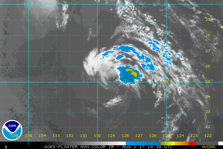
Re: EPAC: IRWIN - Tropical Depression
Tropical Depression Irwin Discussion Number 41
NWS National Hurricane Center Miami FL EP102017
800 AM PDT Tue Aug 01 2017
Irwin basically consists of a tight swirl of low clouds devoid
of deep convection. Dvorak numbers have continued to decrease, and
assuming that winds have diminished since the last ASCAT pass about
8 hours ago, the initial intensity is set at 30 kt.
The cyclone is already moving over cold waters of about 22 deg C.
On this basis, weakening should continue, and Irwin is anticipated
to become a remnant low this afternoon.
Irwin is moving toward the north-northwest or 335 degrees at 9 kt.
A gradual turn toward the northwest is expected today as the cyclone
becomes a shallow system steered by the low-level flow.
FORECAST POSITIONS AND MAX WINDS
INIT 01/1500Z 25.9N 129.2W 30 KT 35 MPH
12H 02/0000Z 27.0N 130.0W 25 KT 30 MPH...POST-TROP/REMNT LOW
24H 02/1200Z 28.0N 131.0W 25 KT 30 MPH...POST-TROP/REMNT LOW
36H 03/0000Z 29.0N 132.0W 20 KT 25 MPH...POST-TROP/REMNT LOW
48H 03/1200Z...DISSIPATED
$$
Forecaster Avila
0 likes
Visit the Caribbean-Central America Weather Thread where you can find at first post web cams,radars
and observations from Caribbean basin members Click Here
and observations from Caribbean basin members Click Here
-
Socalhurcnegirl227
- Category 1

- Posts: 267
- Age: 35
- Joined: Mon Jun 06, 2016 6:39 pm
- Location: Santa Barbara, CA
Re: EPAC: IRWIN - Tropical Depression
Its raining here at my house not sure if its from irwin or dissipation from any of the storm systems out in the epac
0 likes
"I'm a wandress, i'm a one night stand,
dont belong to no city, dont belong to no man
i'm the violence in the pouring rain,
I'm a hurricane"
dont belong to no city, dont belong to no man
i'm the violence in the pouring rain,
I'm a hurricane"
-
Sciencerocks
- Category 5
- Posts: 7282
- Age: 38
- Joined: Thu Jul 06, 2017 1:51 am
Who is online
Users browsing this forum: No registered users and 37 guests