Lixon Avila always has a humor touch to the discussions.
I thought there was no more room for another cyclone in the eastern
Pacific basin, but nature managed to produce another one.
EPAC: IRWIN - Post-Tropical
Moderator: S2k Moderators
-
cycloneye

- Admin

- Posts: 139068
- Age: 67
- Joined: Thu Oct 10, 2002 10:54 am
- Location: San Juan, Puerto Rico
Re: EPAC: TEN-E - Tropical Depression
3 likes
Visit the Caribbean-Central America Weather Thread where you can find at first post web cams,radars
and observations from Caribbean basin members Click Here
and observations from Caribbean basin members Click Here
-
zeehag
- Tropical Storm

- Posts: 172
- Age: 75
- Joined: Sun Jul 17, 2011 9:49 pm
- Location: mazatlan,sinaloa, mexico, fixing patricia's mess.
- Contact:
Re: EPAC: TEN-E - Tropical Depression
this is busiest i have seen my pacific.... i hope they remain away from land.. i am in mazatlan now..watching closely
0 likes
-
Sciencerocks
- Category 5

- Posts: 7286
- Age: 38
- Joined: Thu Jul 06, 2017 1:51 am
-
cycloneye
- Admin
- Posts: 139068
- Age: 67
- Joined: Thu Oct 10, 2002 10:54 am
- Location: San Juan, Puerto Rico
Re: EPAC: TEN-E - Tropical Depression
Tropical Depression Ten-E Discussion Number 2
NWS National Hurricane Center Miami FL EP102017
300 PM MDT Sat Jul 22 2017
Satellite images indicate that the center of the depression remains
sheared, with the complex center on the northeast side of the main
convective mass. Cirrus cloud blowoff from the band in the
northwestward quadrant of the cyclone is pretty clearly moving
right into the center, causing the asymmetric appearance.
Satellite intensity estimates are unchanged, so the initial wind
speed will stay at 30 kt.
The upper-level environment is not ideal for strengthening with a
trough located north of the cyclone. Most of the models lift the
trough northward during the next couple of days, which generally
causes lighter shear. However, in a few days, increasing easterly
shear from the outflow of TD Nine-E is expected to arrest the
strengthening of the cyclone. Model guidance, however, is rather
divergent, with the statistical-based tools showing little
strengthening, while the regional hurricane models all turn the
depression into a significant hurricane in a few days. Given that
this forecast also depends on how much Nine-E strengthens and a
questionable environment, the regional hurricane models look
overdone, so the official forecast will stay on the conservative
side of the guidance.
The depression is moving toward the west at about 6 kt. A ridge
between the depression and TS Greg is forecast to steer Ten-E to the
west or west-southwest over the next several days. Guidance is not
in great agreement, with the GFS and ECMWF showing very different
solutions. The GFS has the strongest ridge, which causes the
depression to take a sharper turn to the southwest, while the ECMWF
is north of all of the other guidance with a weaker ridge and more
of an interaction with TD Nine-E. Despite these significant
differences, the model consensus remains close to the previous NHC
forecast, so little change is made to the latest NHC track
prediction. Given the potential binary track interaction, there is
a lot of uncertainty at long range with the track forecast.
FORECAST POSITIONS AND MAX WINDS
INIT 22/2100Z 14.4N 113.5W 30 KT 35 MPH
12H 23/0600Z 14.5N 114.5W 35 KT 40 MPH
24H 23/1800Z 14.5N 115.6W 40 KT 45 MPH
36H 24/0600Z 14.5N 116.6W 45 KT 50 MPH
48H 24/1800Z 14.5N 117.7W 55 KT 65 MPH
72H 25/1800Z 14.5N 119.8W 60 KT 70 MPH
96H 26/1800Z 14.0N 122.5W 55 KT 65 MPH
120H 27/1800Z 13.5N 125.0W 50 KT 60 MPH
$$
Forecaster Blake
0 likes
Visit the Caribbean-Central America Weather Thread where you can find at first post web cams,radars
and observations from Caribbean basin members Click Here
and observations from Caribbean basin members Click Here
-
Yellow Evan

- Professional-Met

- Posts: 15951
- Age: 25
- Joined: Fri Jul 15, 2011 12:48 pm
- Location: Henderson, Nevada/Honolulu, HI
- Contact:
Re: EPAC: TEN-E - Tropical Depression
EP, 10, 201707230000, 10, DVTS, CI, , 1480N, 11390W, , 2, 30, 2, , , , , , , , , , , , , , , , , E, SAB, JW, VIM, 3, 2020 /////, , , GOES15, LLCC, T, DT=2.0 BO SHR MET=2.0 PT=2.0 FTBO DT
0 likes
-
Yellow Evan
- Professional-Met
- Posts: 15951
- Age: 25
- Joined: Fri Jul 15, 2011 12:48 pm
- Location: Henderson, Nevada/Honolulu, HI
- Contact:
Re: EPAC: TEN-E - Tropical Depression
EP, 10, 2017072300, , BEST, 0, 145N, 1139W, 30, 1006, TD, 34, NEQ, 0, 0, 0, 0, 1012, 180, 40, 0, 0, E, 0, , 0, 0, TEN, S, 0, , 0, 0, 0, 0, genesis-num, 013,
0 likes
-
Yellow Evan
- Professional-Met
- Posts: 15951
- Age: 25
- Joined: Fri Jul 15, 2011 12:48 pm
- Location: Henderson, Nevada/Honolulu, HI
- Contact:
Re: EPAC: TEN-E - Tropical Depression
* EAST PACIFIC SHIPS INTENSITY FORECAST *
* IR SAT DATA AVAILABLE, OHC AVAILABLE *
* TEN EP102017 07/23/17 00 UTC *
TIME (HR) 0 6 12 18 24 36 48 60 72 84 96 108 120
V (KT) NO LAND 30 30 31 33 35 40 49 54 57 59 62 65 66
V (KT) LAND 30 30 31 33 35 40 49 54 57 59 62 65 66
V (KT) LGEM 30 30 30 30 30 30 32 33 34 35 36 39 42
Storm Type TROP TROP TROP TROP TROP TROP TROP TROP TROP TROP TROP TROP TROP
SHEAR (KT) 12 15 15 10 5 4 7 6 13 8 10 10 11
SHEAR ADJ (KT) -1 -1 -1 0 -1 -2 0 1 -2 -4 -3 -3 0
SHEAR DIR 331 339 354 360 5 349 114 159 137 112 99 83 54
SST (C) 27.5 27.5 27.7 27.9 28.0 28.2 28.2 28.1 27.8 27.7 27.9 28.1 28.3
POT. INT. (KT) 138 137 139 141 142 144 144 143 140 140 142 143 145
200 MB T (C) -52.8 -53.1 -53.4 -53.4 -52.9 -53.5 -52.8 -52.7 -51.9 -52.0 -51.2 -51.6 -50.8
200 MB VXT (C) 0.1 0.1 0.0 -0.3 -0.4 -0.5 -0.2 0.1 0.3 0.4 0.2 0.3 0.3
TH_E DEV (C) 8 7 7 7 6 7 6 6 6 5 5 4 4
700-500 MB RH 67 68 69 68 70 68 68 67 66 63 63 64 62
MODEL VTX (KT) 13 13 13 14 14 15 17 18 17 18 18 19 20
850 MB ENV VOR -46 -48 -56 -51 -48 -56 -39 -28 -15 -2 12 20 38
200 MB DIV -4 15 36 39 32 16 24 -18 4 -4 -1 -5 28
700-850 TADV 0 0 -1 0 0 0 2 4 3 2 0 0 0
LAND (KM) 1019 1046 1076 1103 1132 1202 1278 1352 1424 1535 1680 1793 1869
LAT (DEG N) 14.5 14.5 14.5 14.5 14.5 14.5 14.5 14.5 14.5 14.2 13.8 13.6 13.5
LONG(DEG W) 113.9 114.5 115.1 115.6 116.1 117.2 118.3 119.3 120.4 121.7 123.3 124.6 125.5
STM SPEED (KT) 7 6 5 5 5 5 5 5 6 7 7 5 4
HEAT CONTENT 14 17 20 21 22 22 18 19 19 14 16 18 18
FORECAST TRACK FROM OFCI INITIAL HEADING/SPEED (DEG/KT):280/ 8 CX,CY: -7/ 1
T-12 MAX WIND: 30 PRESSURE OF STEERING LEVEL (MB): 555 (MEAN=550)
GOES IR BRIGHTNESS TEMP. STD DEV. 50-200 KM RAD: 29.9 (MEAN=14.5)
% GOES IR PIXELS WITH T < -20 C 50-200 KM RAD: 58.0 (MEAN=65.0)
PRELIM RI PROB (DV .GE. 55 KT IN 48 HR): 1.9
INDIVIDUAL CONTRIBUTIONS TO INTENSITY CHANGE
6 12 18 24 36 48 60 72 84 96 108 120
----------------------------------------------------------
SAMPLE MEAN CHANGE 0. 0. 1. 1. 1. 1. 1. 1. -0. -1. -1. -2.
SST POTENTIAL 0. 1. 2. 3. 7. 12. 18. 22. 25. 26. 27. 27.
VERTICAL SHEAR MAG 1. 1. 2. 2. 4. 5. 5. 4. 4. 4. 4. 4.
VERTICAL SHEAR ADJ 0. 0. 0. 0. 1. 0. 0. 0. 0. 0. 0. 0.
VERTICAL SHEAR DIR -0. -0. -0. -0. -0. 1. 0. 0. 1. 2. 3. 4.
PERSISTENCE -0. -0. -0. -1. -1. -1. -1. -0. -0. -0. 0. 1.
200/250 MB TEMP. 0. -0. -0. -1. -1. -3. -4. -5. -5. -5. -4. -5.
THETA_E EXCESS 0. 0. 0. 0. 1. 1. 1. 0. 0. -0. -1. -1.
700-500 MB RH 0. 0. 0. 0. 0. 0. 1. 1. 1. 2. 2. 2.
MODEL VTX TENDENCY 0. 0. 1. 1. 3. 5. 6. 6. 6. 6. 7. 7.
850 MB ENV VORTICITY 0. 0. 0. 0. 1. 1. 2. 2. 2. 2. 2. 2.
200 MB DIVERGENCE -0. -0. -1. -1. -1. -1. -2. -2. -2. -2. -2. -2.
850-700 T ADVEC 0. 0. -0. -0. 0. 0. 0. 0. 1. 1. 1. 1.
ZONAL STORM MOTION 0. 0. 0. 0. 0. 0. 0. 0. -0. -0. -0. -0.
STEERING LEVEL PRES 0. -0. -0. -0. -0. -0. -0. -0. -0. -0. -0. -0.
DAYS FROM CLIM. PEAK -0. -0. -0. -0. 0. -0. -0. -0. -1. -1. -1. -1.
GOES PREDICTORS -1. -1. -2. -2. -3. -3. -3. -3. -2. -2. -2. -2.
OCEAN HEAT CONTENT -0. -0. -0. -0. 0. 0. 0. 0. 0. 0. 0. -0.
----------------------------------------------------------
TOTAL CHANGE 0. 1. 3. 5. 10. 19. 24. 27. 29. 32. 35. 36.
CURRENT MAX WIND (KT): 30. LAT, LON: 14.5 113.9
** 2017 E.PACIFIC RI INDEX EP102017 TEN 07/23/17 00 UTC **
(SHIPS-RII PREDICTOR TABLE for 30 KT OR MORE MAXIMUM WIND INCREASE IN NEXT 24-h)
Predictor Value RI Predictor Range Scaled Value(0-1) % Contribution
12 HR PERSISTENCE (KT): 0.0 -22.0 to 44.0 0.33 0.2
POT = MPI-VMAX (KT) : 109.4 40.5 to 149.3 0.63 0.3
850-200 MB SHEAR (KT) : 11.5 18.9 to 1.4 0.42 0.2
HEAT CONTENT (KJ/cm2) : 18.8 0.0 to 106.7 0.18 0.1
MAXIMUM WIND (kt) : 30.0 22.5 to 132.0 0.21 0.1
D200 (10**7s-1) : 23.6 -33.0 to 156.2 0.30 0.1
STD DEV OF IR BR TEMP : 29.9 37.8 to 2.1 0.22 0.1
% AREA WITH TPW <45 mm: 0.0 62.3 to 0.0 1.00 -0.1
2nd PC OF IR BR TEMP : 2.0 2.2 to -1.9 0.04 0.0
BL DRY-AIR FLUX (w/m2): 115.4 735.9 to -82.5 0.76 0.0
SHIPS Prob RI for 20kt/ 12hr RI threshold= 2% is 0.2 times sample mean ( 7.7%)
SHIPS Prob RI for 25kt/ 24hr RI threshold= 10% is 0.4 times sample mean (15.3%)
SHIPS Prob RI for 30kt/ 24hr RI threshold= 1% is 0.6 times sample mean (10.4%)
SHIPS Prob RI for 35kt/ 24hr RI threshold= 0% is 0.0 times sample mean ( 7.5%)
SHIPS Prob RI for 40kt/ 24hr RI threshold= 0% is 0.0 times sample mean ( 5.2%)
SHIPS Prob RI for 45kt/ 36hr RI threshold= 10% is 1.3 times sample mean ( 8.1%)
SHIPS Prob RI for 55kt/ 48hr RI threshold= 0% is 0.0 times sample mean ( 7.4%)
SHIPS Prob RI for 65kt/ 72hr RI threshold= 0% is 0.0 times sample mean ( 5.5%)
Matrix of RI probabilities
------------------------------------------------------------------------------
RI (kt / h) | 20/12 | 25/24 | 30/24 | 35/24 | 40/24 | 45/36 | 55/48 |65/72
------------------------------------------------------------------------------
SHIPS-RII: 1.9% 10.4% 1.0% 0.0% 0.0% 10.3% 0.0% 0.0%
Logistic: 0.3% 1.7% 0.7% 0.5% 0.2% 1.2% 2.5% 5.2%
Bayesian: 0.0% 0.1% 0.0% 0.0% 0.0% 0.0% 0.1% 0.3%
Consensus: 0.7% 4.1% 0.6% 0.2% 0.1% 3.8% 0.9% 1.8%
## ANNULAR HURRICANE INDEX (AHI) EP102017 TEN 07/23/17 00 UTC ##
## STORM NOT ANNULAR, SCREENING STEP FAILED, NPASS=4 NFAIL=3 ##
## AHI= 0 (AHI OF 100 IS BEST FIT TO ANN. STRUC., 1 IS MARGINAL, 0 IS NOT ANNULAR) ##
0 likes
-
Sciencerocks
- Category 5
- Posts: 7286
- Age: 38
- Joined: Thu Jul 06, 2017 1:51 am
-
Sciencerocks
- Category 5
- Posts: 7286
- Age: 38
- Joined: Thu Jul 06, 2017 1:51 am
Re: EPAC: TEN-E - Tropical Depression
000
WTPZ45 KNHC 230249
TCDEP5
Tropical Depression Ten-E Discussion Number 3
NWS National Hurricane Center Miami FL EP102017
900 PM MDT Sat Jul 22 2017
Last-light visible images indicate that the low-level center of
Tropical Depression Ten-E remains exposed just to the north of the
main convective mass due to the effects of 10-15 kt of northerly
vertical wind shear. Satellite intensity estimates are 30 kt from
TAFB and SAB, so that will remain the initial intensity.
The intensity forecast is low confidence due to a large spread in
the guidance and the possibility of interaction with Tropical
Storm Hilary to the east late in the forecast period. All guidance
agrees that northerly shear produced by a nearby upper-level trough
should continue for the next 36 h, and based on this, the forecast
is for slow strengthening. The models forecast a somewhat more
favorable environment from 36-72 h, but the guidance becomes very
divergent on how this will affect the cyclone. By 72 hr, the LGEM
forecasts a 35 kt intensity, the HWRF an 85 kt intensity, and
several other reliable models in between those extremes. After 72
hr, the cyclone may feel the impact of outflow from Hilary, which
would likely stop any strengthening. The new intensity forecast is
only slightly changed from the previous forecast, and it lies near
the center of a well spread out guidance envelope.
The initial motion is 280/7. A ridge between the depression and
Tropical Storm Greg to the west is forecast to steer Ten-E to the
west or west-southwest over the next several days. Near the end of
the forecast period, the track could be affected by interaction with
Hilary, although only the GFS shows a major impact before 120 h and
thus it is to the southeast of the other models. The new forecast
track is little changed from the previous track and uses the premise
that the main track impact from the aforementioned interaction will
be after 120 h.
FORECAST POSITIONS AND MAX WINDS
INIT 23/0300Z 14.6N 114.2W 30 KT 35 MPH
12H 23/1200Z 14.6N 115.1W 35 KT 40 MPH
24H 24/0000Z 14.6N 116.2W 40 KT 45 MPH
36H 24/1200Z 14.7N 117.2W 45 KT 50 MPH
48H 25/0000Z 14.7N 118.2W 55 KT 65 MPH
72H 26/0000Z 14.5N 120.5W 60 KT 70 MPH
96H 27/0000Z 14.0N 123.0W 60 KT 70 MPH
120H 28/0000Z 13.5N 126.0W 55 KT 65 MPH
$$
Forecaster Beven
0 likes
-
Yellow Evan
- Professional-Met
- Posts: 15951
- Age: 25
- Joined: Fri Jul 15, 2011 12:48 pm
- Location: Henderson, Nevada/Honolulu, HI
- Contact:
Re: EPAC: TEN-E - Tropical Depression
EP, 10, 201707230516, 31, ASCT, CIR, , 1450N, 11470W, , 1, 34, 3, , 3, , 34, NEQ, 30, 0, 0, 0, , , , , 3, , , , NHC, DAZ, , , , , , , , , ASCT, 34, NEQ, 30, 0, 0, 0, 0, 0, 0, 0, , , , , , , , , 3,
0 likes
-
Yellow Evan
- Professional-Met
- Posts: 15951
- Age: 25
- Joined: Fri Jul 15, 2011 12:48 pm
- Location: Henderson, Nevada/Honolulu, HI
- Contact:
Re: EPAC: TEN-E - Tropical Depression
EP, 10, 2017072306, , BEST, 0, 146N, 1148W, 35, 1005, TS, 34, NEQ, 30, 0, 0, 0, 1012, 180, 25, 0, 0, E, 0, , 0, 0, TEN, S, 0, , 0, 0, 0, 0, genesis-num, 013,
0 likes
-
Sciencerocks
- Category 5
- Posts: 7286
- Age: 38
- Joined: Thu Jul 06, 2017 1:51 am
-
Sciencerocks
- Category 5
- Posts: 7286
- Age: 38
- Joined: Thu Jul 06, 2017 1:51 am
Re: EPAC: IRWIN - Tropical Storm
000
WTPZ45 KNHC 230853
TCDEP5
Tropical Storm Irwin Discussion Number 4
NWS National Hurricane Center Miami FL EP102017
200 AM PDT Sun Jul 23 2017
An ASCAT-B overpass at 0516 UTC showed several vectors of 32-33 kt
winds and a max value of 34 kt in the northeast quadrant of the
tropical cyclone. Based on that data, the system has been named
Tropical Storm Irwin. Irwin is the fifth system to be named in the
eastern North Pacific so far in July.
Although the system has been upgraded based on the ASCAT data, the
structure has not improved. Shortwave-IR imagery shows that the
low-level center is clearly exposed to the northwest of the deep
convection, and Dvorak intensity estimates from TAFB and SAB have
not increased. The global models suggest that the shear should
decrease quite a bit after about 12 to 24 hours, which should allow
for some intensification. The regional dynamical models HWRF and
COAMPS-TC depict Irwin quickly recovering from its current sheared
state and intensifying to a category 2 or 3 hurricane. On the other
hand, the statistical models still only show modest strengthening,
and keep Irwin below hurricane strength. As a course of least
regret, the intensity forecast splits these two scenarios, but
slightly favors the lower statistical guidance since the dynamical
models may show the structure of Irwin recovering from the current
shear too quickly. Near the end of the forecast period, Irwin is
expected to encounter a higher shear environment, due in part to
outflow from Hilary to the east, so the forecast depicts gradual
weakening.
The initial motion is 280/6 kt. Irwin continues to be steered by a
low- to mid-level ridge to the northwest. Although no significant
changes have been made to the track forecast, confidence is still
somewhat low since there is a fair amount of speed-spread in the
models. The GFS remains an outlier in being the only model that
shows substantial binary interaction with Hilary, and is thus the
farthest east, though the 00 UTC ECMWF is also a little slower
than before. The official forecast is a little slower at the end of
forecast period than the previous advisory, but still assumes that
any significant track deviation due to interactions with Hilary
will occur beyond 120 h.
FORECAST POSITIONS AND MAX WINDS
INIT 23/0900Z 14.7N 115.2W 35 KT 40 MPH
12H 23/1800Z 14.8N 116.0W 40 KT 45 MPH
24H 24/0600Z 14.9N 117.0W 45 KT 50 MPH
36H 24/1800Z 15.0N 118.0W 50 KT 60 MPH
48H 25/0600Z 15.0N 118.8W 60 KT 70 MPH
72H 26/0600Z 14.7N 121.0W 65 KT 75 MPH
96H 27/0600Z 14.5N 123.1W 60 KT 70 MPH
120H 28/0600Z 14.0N 125.5W 55 KT 65 MPH
$$
Forecaster Zelinsky
0 likes
-
cycloneye
- Admin
- Posts: 139068
- Age: 67
- Joined: Thu Oct 10, 2002 10:54 am
- Location: San Juan, Puerto Rico
Re: EPAC: IRWIN - Tropical Storm
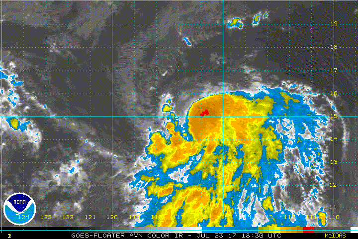
Tropical Storm Irwin Discussion Number 5
NWS National Hurricane Center Miami FL EP102017
800 AM PDT Sun Jul 23 2017
Irwin's center is exposed to the north and west of its associated
deep convection due to about 15 kt of northerly shear. Subjective
and objective Dvorak intensity estimates are a consensus T2.5, so
35 kt will remain the initial intensity for this advisory.
The initial motion remains westward at 280/6 kt, with Irwin located
south of a weak low-level ridge and almost midway between Tropical
Storms Greg and Hilary. This orientation should cause Irwin to
maintain a westward, albeit much slower, motion during the next
several days. However, once Greg degenerates into a remnant low in
about 4 days, a binary interaction between a stronger Irwin and
Hilary is more likely to occur, which could force Irwin to turn
west-southwestward at the end of the forecast period. There is
some notable spread in the guidance, highlighted by the GFS and its
ensemble mean on the southern end of the guidance envelope, and the
ECMWF and its ensemble mean on the northern edge. The HWRF is also
north of most models by the end of the forecast period, presumably
because it is not capturing any interaction between Irwin and
Hilary. The updated NHC forecast is nudged a little south on this
advisory, and it is south of the model consensus after day 3 to
account for an Irwin-Hilary track interaction.
The shear over Irwin is expected to decrease within the next 12-24
hours, which should allow the cyclone to begin a sustained period
of strengthening. Sea surface temperatures will be between 27-28
degrees Celsius, and the ambient environment appears sufficiently
moist to foster intensification. The NHC intensity forecast favors
a blend of the ICON intensity consensus, HCCA, and the Florida
State Superensemble, showing Irwin reaching hurricane intensity in
about 48 hours. This forecast is not too different from the
previous advisory.
FORECAST POSITIONS AND MAX WINDS
INIT 23/1500Z 15.0N 115.8W 35 KT 40 MPH
12H 24/0000Z 15.0N 116.6W 40 KT 45 MPH
24H 24/1200Z 15.0N 117.5W 50 KT 60 MPH
36H 25/0000Z 15.0N 118.2W 60 KT 70 MPH
48H 25/1200Z 15.0N 119.1W 65 KT 75 MPH
72H 26/1200Z 14.8N 121.4W 65 KT 75 MPH
96H 27/1200Z 14.2N 123.9W 60 KT 70 MPH
120H 28/1200Z 14.0N 125.4W 55 KT 65 MPH
$$
Forecaster Berg
0 likes
Visit the Caribbean-Central America Weather Thread where you can find at first post web cams,radars
and observations from Caribbean basin members Click Here
and observations from Caribbean basin members Click Here
-
Kingarabian

- S2K Supporter

- Posts: 15434
- Joined: Sat Aug 08, 2009 3:06 am
- Location: Honolulu, Hawaii


Re: EPAC: IRWIN - Tropical Storm
ATCF Best Track
System ID: EP10 (IRWIN)
1800 UTC Jul 23, 2017
Location: 14.9°N, 116.3°W
Central Pressure: 1003 mb
Maximum Winds (1-min): 40 kt (46 mph)
Type: Tropical Storm (TS)
ACE (Storm Total): 0.405
System ID: EP10 (IRWIN)
1800 UTC Jul 23, 2017
Location: 14.9°N, 116.3°W
Central Pressure: 1003 mb
Maximum Winds (1-min): 40 kt (46 mph)
Type: Tropical Storm (TS)
ACE (Storm Total): 0.405
0 likes
-
cycloneye
- Admin
- Posts: 139068
- Age: 67
- Joined: Thu Oct 10, 2002 10:54 am
- Location: San Juan, Puerto Rico
Re: EPAC: IRWIN - Tropical Storm
Tropical Storm Irwin Discussion Number 6
NWS National Hurricane Center Miami FL EP102017
200 PM PDT Sun Jul 23 2017
Deep convection has covered up Irwin's center since the last
advisory, a sign that the shear affecting the system continues to
diminish. Dvorak intensity estimates have increased to T3.0/45 kt
from TAFB and SAB, but objective numbers are still at T2.5/35 kt.
Based on these estimates, and a 1748 UTC ASCAT-B pass, the initial
intensity is raised to 40 kt.
Irwin is moving westward, or 270/7 kt, between Tropical Storms Greg
and Hilary and to the south of a weak low- to mid-level ridge
extending west of the Baja California peninsula. Since the ridge
is expected to remain weak, Irwin is forecast to move only slowly
westward through 48 hours. After that time, its motion is likely
to become increasingly influenced by Hilary, with the two beginning
some degree of a binary interaction. The track guidance now
indicates that Irwin will turn west-southwestward on days 3 and 4,
and then possibly turn back to the northeast around Hilary's
southern side on day 5. With a shift in the overall guidance
envelope, the new NHC track forecast has been shifted southward
toward HCCA and the TVCN multi-model consensus, and it also now
shows Irwin stalling or drifting northward on day 5.
Irwin is located over warm sea surface temperatures and in a
relatively moist environment, and the northerly shear affecting the
cyclone should continue to decrease over the next day or so.
Therefore, additional gradual strengthening is anticipated, and
Irwin has the possibility of reaching hurricane strength in about
48 hours. After that time, Hilary (possibly as a major hurricane)
will be getting closer to Irwin, and its upper-level outflow could
cause stronger shear to develop over Irwin. The intensity guidance
has responded to this possibility by showing more pronounced
weakening after 48 hours, and the new NHC intensity forecast now
shows Irwin holding a steady intensity as a tropical storm on days 3
through 5. This forecast remains closest to HCCA and the ICON
intensity consensus.
FORECAST POSITIONS AND MAX WINDS
INIT 23/2100Z 14.9N 116.6W 40 KT 45 MPH
12H 24/0600Z 14.8N 117.3W 45 KT 50 MPH
24H 24/1800Z 14.7N 118.1W 50 KT 60 MPH
36H 25/0600Z 14.6N 118.9W 60 KT 70 MPH
48H 25/1800Z 14.5N 119.8W 65 KT 75 MPH
72H 26/1800Z 14.0N 122.1W 55 KT 65 MPH
96H 27/1800Z 13.5N 123.5W 55 KT 65 MPH
120H 28/1800Z 14.0N 123.5W 55 KT 65 MPH
$$
Forecaster Berg
0 likes
Visit the Caribbean-Central America Weather Thread where you can find at first post web cams,radars
and observations from Caribbean basin members Click Here
and observations from Caribbean basin members Click Here
-
Yellow Evan
- Professional-Met
- Posts: 15951
- Age: 25
- Joined: Fri Jul 15, 2011 12:48 pm
- Location: Henderson, Nevada/Honolulu, HI
- Contact:
Re: EPAC: IRWIN - Tropical Storm
EP, 10, 2017072400, , BEST, 0, 149N, 1170W, 45, 1001, TS, 34, NEQ, 70, 30, 20, 50, 1009, 150, 30, 0, 0, E, 0, , 0, 0, IRWIN, M, 0, , 0, 0, 0, 0, genesis-num, 013,
0 likes
-
Sciencerocks
- Category 5
- Posts: 7286
- Age: 38
- Joined: Thu Jul 06, 2017 1:51 am
-
Kingarabian
- S2K Supporter
- Posts: 15434
- Joined: Sat Aug 08, 2009 3:06 am
- Location: Honolulu, Hawaii
Re: EPAC: IRWIN - Tropical Storm
Quite a burst of convection that is. It'll be a hurricane soon. 
0 likes
RIP Kobe Bryant
Who is online
Users browsing this forum: No registered users and 118 guests