EPAC: KENNETH - Post-Tropical

Moderator: S2k Moderators

Message
Author
User avatar
gigabite
S2K Supporter
S2K Supporter
Posts: 916
Age: 70
Joined: Wed May 05, 2004 4:09 pm
Location: Naples, Florida

Re: EPAC: KENNETH - Hurricane

#101 Postby gigabite » Mon Aug 21, 2017 5:39 pm

Image
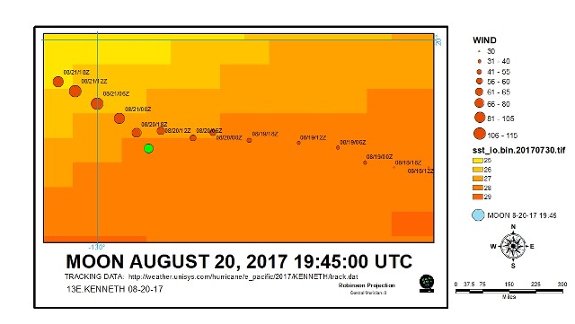
This is a map of the track of EPAC:KENNETH 2017, and showing the point at which the New Moons sub-point intersected the storm. The background color is the sea surface temperature from July 30, 2017.
0 likes   

User avatar
cycloneye
Admin
Admin
Posts: 139028
Age: 67
Joined: Thu Oct 10, 2002 10:54 am
Location: San Juan, Puerto Rico

Re: EPAC: KENNETH - Hurricane

#102 Postby cycloneye » Mon Aug 21, 2017 9:40 pm

Hurricane Kenneth Discussion Number 15
NWS National Hurricane Center Miami FL EP132017
800 PM PDT Mon Aug 21 2017

Kenneth's previously distinct eye is clouding over as its eye
temperature cools, while the surrounding eyewall convection warms
and weakens. Correspondingly, the Dvorak classifications from TAFB,
SAB, and ADT have dropped and a blend of them suggests an intensity
of 95 kt at 00Z. Continued deterioration of the convective
structure is justification for maximum winds of 90 kt at advisory
time. While no recent size observations have been available,
earlier AMSU estimates along with the limited extent of the cold
cloud canopy suggest that Kenneth is a small tropical cyclone with
tropical-storm-force winds extending out about 80 nm from the
center on average.

Kenneth should continue to weaken - perhaps rapidly - under the
influence of cool to cold SSTs, dry and less unstable air, and
increasing southwesterly vertical shear. Kenneth should likely
lose all of its organized deep convection in 2-3 days, signaling
its transformation to a post-tropical cyclone at that time. The
official intensity forecast is based upon the tightly packed
dynamical and statistical model guidance and is a bit lower than the
previous advisory.

The hurricane is moving toward the northwest at about 9 kt, as it
rounds the southwestern periphery of a weak mid-level ridge and
toward a mid- to upper-level low farther north. Over the next
couple of days, Kenneth should turn toward the north-northwest at
about the same rate of speed. Once Kenneth becomes a post-tropical
cyclone, it should turn back toward the northwest and slow its
forward speed within the weak, low-level tradewinds. The official
track forecast is based upon the usually reliable global and
hurricane dynamical models, minus the substantially slower and to
the left UKMET solution (which has not been performing well thus far
this season). The new track forecast is slightly northeast of the
previous advisory.

FORECAST POSITIONS AND MAX WINDS

INIT 22/0300Z 19.2N 132.1W 90 KT 105 MPH
12H 22/1200Z 20.4N 132.9W 75 KT 85 MPH
24H 23/0000Z 22.2N 134.0W 60 KT 70 MPH
36H 23/1200Z 24.0N 134.9W 50 KT 60 MPH
48H 24/0000Z 25.6N 135.8W 40 KT 45 MPH
72H 25/0000Z 28.5N 136.4W 35 KT 40 MPH...POST-TROPICAL
96H 26/0000Z 30.5N 137.0W 30 KT 35 MPH...POST-TROP/REMNT LOW
120H 27/0000Z 31.5N 137.5W 25 KT 30 MPH...POST-TROP/REMNT LOW

$$
Forecaster Landsea
0 likes   
Visit the Caribbean-Central America Weather Thread where you can find at first post web cams,radars
and observations from Caribbean basin members Click Here
User avatar
cycloneye
Admin
Admin
Posts: 139028
Age: 67
Joined: Thu Oct 10, 2002 10:54 am
Location: San Juan, Puerto Rico

Re: EPAC: KENNETH - Hurricane

#103 Postby cycloneye » Tue Aug 22, 2017 8:09 am

Hurricane Kenneth Discussion Number 16
NWS National Hurricane Center Miami FL EP132017
200 AM PDT Tue Aug 22 2017

Kenneth is quickly weakening this morning. Recent microwave images
show that the inner-core structure has eroded and that the low-level
center is displaced to the southwest of the mid-level center due to
moderate southwesterly shear. Subjective and objective Dvorak
T-numbers are decreasing and the initial intensity is set at 80 kt,
which is a blend of the various final T- and CI-numbers.

The hurricane is expected to continue to rapidly weaken during the
next day or so while it moves over progressively cooler sea surface
temperatures and into an area of increasing southwesterly vertical
wind shear. Kenneth should weaken to a tropical storm later today,
and become post-tropical in 2-3 days, if not sooner. The NHC
intensity forecast is in good agreement with the HFIP corrected
consensus model, but is a little lower than the statistical guidance
and the previous advisory.

Kenneth is moving northwestward or 325/9 kt. The cyclone should
turn north-northwestward today between a mid-level ridge to its
east and a cut-off low to the west. As Kenneth weakens, it is
predicted to slow down and turn northwestward by the end of the
forecast period. The track models are in excellent agreement
through 48-72 hours, but diverge somewhat after Kenneth weakens
and becomes post-tropical. The official track forecast is close to
the GFS/ECMWF consensus and is not much different than the previous
NHC advisory.

The 34- and 50-kt wind radii have been adjusted slightly inward
based on a couple of recent ASCAT overpass.


FORECAST POSITIONS AND MAX WINDS

INIT 22/0900Z 20.0N 132.5W 80 KT 90 MPH
12H 22/1800Z 21.3N 133.3W 60 KT 70 MPH
24H 23/0600Z 23.2N 134.3W 45 KT 50 MPH
36H 23/1800Z 25.1N 135.3W 35 KT 40 MPH
48H 24/0600Z 26.6N 136.1W 30 KT 35 MPH
72H 25/0600Z 28.7N 136.5W 25 KT 30 MPH...POST-TROP/REMNT LOW
96H 26/0600Z 30.0N 137.0W 25 KT 30 MPH...POST-TROP/REMNT LOW
120H 27/0600Z 31.0N 138.0W 20 KT 25 MPH...POST-TROP/REMNT LOW

$$
Forecaster Brown
0 likes   
Visit the Caribbean-Central America Weather Thread where you can find at first post web cams,radars
and observations from Caribbean basin members Click Here

User avatar
cycloneye
Admin
Admin
Posts: 139028
Age: 67
Joined: Thu Oct 10, 2002 10:54 am
Location: San Juan, Puerto Rico

Re: EPAC: KENNETH - Hurricane

#104 Postby cycloneye » Tue Aug 22, 2017 9:37 am

Hurricane Kenneth Discussion Number 17
NWS National Hurricane Center Miami FL EP132017
800 AM PDT Tue Aug 22 2017

Kenneth is moving over SSTs below 26 deg C and continues to weaken.
Using a blend of CI- and T-numbers from TAFB and SAB, the current
intensity is set to 70 kt. Continued weakening is likely as the
cyclone moves over progressively cooler waters and increasing
south-southwesterly shear associated with a broad upper-level trough
to the west of Kenneth. The official intensity forecast is close to
the latest D-SHIPS guidance and calls for the system to decay
rapidly to a tropical depression in 36 hours and to a remnant low in
48 hours, although this could occur even sooner than shown here.

Microwave data suggest that the low-level center is displaced a bit
to the southwest of the mid-level center. The initial motion is
now estimated to be north-northwestward or 330/10 kt. No
significant changes have been made to the track forecast or
reasoning. Global models show a break in the subtropical ridge
associated with a mid-level trough near 140W longitude over the
next few days. Kenneth should continue to move north-northwestward
through the break until later in the forecast period when the
shallow cyclone is likely to turn to the left following the
low-level flow. The official track forecast follows the latest
dynamical model consensus.

FORECAST POSITIONS AND MAX WINDS

INIT 22/1500Z 20.9N 133.1W 70 KT 80 MPH
12H 23/0000Z 22.2N 133.9W 55 KT 65 MPH
24H 23/1200Z 24.1N 134.8W 40 KT 45 MPH
36H 24/0000Z 25.7N 135.8W 30 KT 35 MPH
48H 24/1200Z 27.1N 136.6W 25 KT 30 MPH...POST-TROP/REMNT LOW
72H 25/1200Z 28.7N 136.9W 25 KT 30 MPH...POST-TROP/REMNT LOW
96H 26/1200Z 30.0N 138.0W 20 KT 25 MPH...POST-TROP/REMNT LOW
120H 27/1200Z 31.0N 140.0W 20 KT 25 MPH...POST-TROP/REMNT LOW

$$
Forecaster Pasch
0 likes   
Visit the Caribbean-Central America Weather Thread where you can find at first post web cams,radars
and observations from Caribbean basin members Click Here

WeatherGuesser
Category 5
Category 5
Posts: 2672
Joined: Tue Jun 29, 2010 6:46 am

Re: EPAC: KENNETH - Hurricane

#105 Postby WeatherGuesser » Tue Aug 22, 2017 12:49 pm

Looks like Kenny's lost and just loitering out there, not really sure where to go.
0 likes   

User avatar
cycloneye
Admin
Admin
Posts: 139028
Age: 67
Joined: Thu Oct 10, 2002 10:54 am
Location: San Juan, Puerto Rico

Re: EPAC: KENNETH - Hurricane

#106 Postby cycloneye » Tue Aug 22, 2017 3:38 pm

Tropical Storm Kenneth Discussion Number 18
NWS National Hurricane Center Miami FL EP132017
200 PM PDT Tue Aug 22 2017

Kenneth's associated deep convection has been diminishing in
coverage and intensity. The tropical cyclone is now traversing SSTs
below 25 deg C, and continues to weaken. Using a blend of Dvorak T-
and CI-numbers from TAFB and SAB gives a current intensity estimate
of 60 kt, bringing the system below hurricane strength. Continued
weakening at a fairly rapid pace is expected while the system
moves over progressively cooler waters and encounters strong shear.
The official intensity forecast is close to the latest Florida State
University Superensemble prediction, and Kenneth should weaken to a
depression and degenerate to a remnant low in 48 hours or sooner.

The initial motion estimate remains 330/10 kt. There is no need
to make significant changes to the track forecast from the previous
advisory package. Kenneth should continue to move through a
weakness in the subtropical ridge created by a mid-level trough
near 140W longitude. Later in the forecast period, the shallow
vortex should turn leftward following the low-level flow. The
official track forecast is only slightly to the right of the
consensus, and leans toward the GFS and ECMWF tracks.

FORECAST POSITIONS AND MAX WINDS

INIT 22/2100Z 21.8N 133.6W 60 KT 70 MPH
12H 23/0600Z 23.1N 134.3W 50 KT 60 MPH
24H 23/1800Z 24.9N 135.3W 40 KT 45 MPH
36H 24/0600Z 26.3N 136.0W 30 KT 35 MPH
48H 24/1800Z 27.5N 136.6W 25 KT 30 MPH...POST-TROP/REMNT LOW
72H 25/1800Z 29.0N 137.3W 25 KT 30 MPH...POST-TROP/REMNT LOW
96H 26/1800Z 30.0N 138.0W 20 KT 25 MPH...POST-TROP/REMNT LOW
120H 27/1800Z 31.0N 140.0W 20 KT 25 MPH...POST-TROP/REMNT LOW

$$
Forecaster Pasch
0 likes   
Visit the Caribbean-Central America Weather Thread where you can find at first post web cams,radars
and observations from Caribbean basin members Click Here

User avatar
cycloneye
Admin
Admin
Posts: 139028
Age: 67
Joined: Thu Oct 10, 2002 10:54 am
Location: San Juan, Puerto Rico

Re: EPAC: KENNETH - Tropical Storm

#107 Postby cycloneye » Tue Aug 22, 2017 9:41 pm

Tropical Storm Kenneth Discussion Number 19
NWS National Hurricane Center Miami FL EP132017
800 PM PDT Tue Aug 22 2017

Kenneth continues to slowly weaken. The eye feature that was
evident several hours ago has filled in, and a recent SSMIS
microwave pass shows that the system is now more asymmetric due to
southerly shear. A pair of ASCAT passes from around 1800 UTC showed
maximum winds in the 55-60 kt range. Assuming some weakening since
the time of that data, the initial wind speed is lowered to 55 kt.
This estimate is also in agreement with a blend of the latest T- and
CI-numbers from TAFB/SAB and ADT values from CIMSS at the University
of Wisconsin.

Kenneth is over cool 24 deg C waters, surrounded by dry air, and
moving toward an environment of even higher southerly wind shear.
These hostile conditions should cause the system to keep weakening,
and the NHC forecast now calls for Kenneth to become a remnant low
in 36 hours. The remnant low will likely only slowly spin down as
depicted by the global models. This intensity forecast is largely
an update of the previous one.

The tropical storm is moving north-northwestward at 10 kt on the
west side of a mid-level ridge. This general motion with a
decrease in forward speed is expected during the next few days while
the system moves into a pronounced weakness in the ridge. By the
end of the forecast period, the shallow cyclone is expected to turn
to the northwest in the low-level flow. Little change was made to
the previous NHC track prediction, and this forecast lies closest
to the various consensus models.

FORECAST POSITIONS AND MAX WINDS

INIT 23/0300Z 22.6N 134.0W 55 KT 65 MPH
12H 23/1200Z 24.0N 134.7W 50 KT 60 MPH
24H 24/0000Z 25.7N 135.7W 40 KT 45 MPH
36H 24/1200Z 27.0N 136.4W 30 KT 35 MPH...POST-TROP/REMNT LOW
48H 25/0000Z 28.0N 136.8W 30 KT 35 MPH...POST-TROP/REMNT LOW
72H 26/0000Z 29.2N 137.5W 25 KT 30 MPH...POST-TROP/REMNT LOW
96H 27/0000Z 30.2N 138.7W 20 KT 25 MPH...POST-TROP/REMNT LOW
120H 28/0000Z 31.5N 140.5W 20 KT 25 MPH...POST-TROP/REMNT LOW

$$
Forecaster Cangialosi
0 likes   
Visit the Caribbean-Central America Weather Thread where you can find at first post web cams,radars
and observations from Caribbean basin members Click Here

User avatar
cycloneye
Admin
Admin
Posts: 139028
Age: 67
Joined: Thu Oct 10, 2002 10:54 am
Location: San Juan, Puerto Rico

Re: EPAC: KENNETH - Post-Tropical

#108 Postby cycloneye » Wed Aug 23, 2017 3:37 pm

Post-Tropical Cyclone Kenneth Discussion Number 22
NWS National Hurricane Center Miami FL EP132017
200 PM PDT Wed Aug 23 2017

Kenneth's organized deep convection has been gone for over 12 hours
now. Satellite images also suggest it is losing its tropical
character, with some possible frontal structures developing near
and northeast of the center. Thus, it no longer meets the
requirements of a tropical cyclone, and this is the final advisory.
The wind speed is held at 35 kt owing to the tight low-level
circulation seen on visible imagery. The post-tropical cyclone
should gradually spin down over cold waters and generally move
north-northwestward with some decrease in forward speed over the
next couple of days. Later in the forecast period, when the cyclone
is likely to be very weak and shallow, a turn toward the northwest
is expected following the low-level flow. The official track
forecast is very close to the previous one.

FORECAST POSITIONS AND MAX WINDS

INIT 23/2100Z 25.4N 135.6W 35 KT 40 MPH...POST-TROPICAL
12H 24/0600Z 26.4N 136.3W 30 KT 35 MPH...POST-TROP/REMNT LOW
24H 24/1800Z 27.5N 136.8W 30 KT 35 MPH...POST-TROP/REMNT LOW
36H 25/0600Z 28.1N 136.9W 25 KT 30 MPH...POST-TROP/REMNT LOW
48H 25/1800Z 28.7N 137.0W 25 KT 30 MPH...POST-TROP/REMNT LOW
72H 26/1800Z 30.0N 138.0W 20 KT 25 MPH...POST-TROP/REMNT LOW
96H 27/1800Z 31.2N 139.8W 20 KT 25 MPH...POST-TROP/REMNT LOW
120H 28/1800Z...DISSIPATED

$$
Forecaster Blake
0 likes   
Visit the Caribbean-Central America Weather Thread where you can find at first post web cams,radars
and observations from Caribbean basin members Click Here

User avatar
Iune
Category 1
Category 1
Posts: 291
Joined: Mon Aug 04, 2008 12:23 pm
Location: New York City

Re: EPAC: KENNETH - Post-Tropical

#109 Postby Iune » Wed Aug 23, 2017 4:04 pm

At least 2017's incarnation of Kenneth maintained the streak of all storms reaching Category 4 intensity. :P
0 likes   
Floyd 1999 · Irene 2011 · Sandy 2012

User avatar
AnnularCane
S2K Supporter
S2K Supporter
Posts: 2634
Joined: Thu Jun 08, 2006 9:18 am
Location: Wytheville, VA

Re: EPAC: KENNETH - Post-Tropical

#110 Postby AnnularCane » Wed Aug 23, 2017 5:54 pm

OMG, they killed Kenny!

(Sorry, I kind of had to. :P )
1 likes   


Return to “2017”

Who is online

Users browsing this forum: No registered users and 78 guests