BULLETIN
Tropical Storm Lidia Intermediate Advisory Number 5A
NWS National Hurricane Center Miami FL EP142017
600 PM MDT Wed Aug 30 2017
...LARGE DISTURBANCE SOUTH OF MEXICO IS NOW TROPICAL STORM LIDIA...
...VERY HEAVY RAIN CONTINUING OVER SOUTHWESTERN MEXICO...
SUMMARY OF 600 PM MDT...0000 UTC...INFORMATION
----------------------------------------------
LOCATION...20.4N 109.0W
ABOUT 180 MI...290 KM SSE OF THE SOUTHERN TIP OF BAJA CALIFORNIA
MAXIMUM SUSTAINED WINDS...40 MPH...65 KM/H
PRESENT MOVEMENT...NNW OR 345 DEGREES AT 7 MPH...11 KM/H
MINIMUM CENTRAL PRESSURE...1001 MB...29.56 INCHES
EPAC: LIDIA - Post-Tropical
Moderator: S2k Moderators
-
cycloneye

- Admin

- Posts: 139021
- Age: 67
- Joined: Thu Oct 10, 2002 10:54 am
- Location: San Juan, Puerto Rico
Re: EPAC: FOURTEEN-E - Potential Tropical Cyclone
0 likes
Visit the Caribbean-Central America Weather Thread where you can find at first post web cams,radars
and observations from Caribbean basin members Click Here
and observations from Caribbean basin members Click Here
-
1900hurricane

- Category 5

- Posts: 6044
- Age: 32
- Joined: Fri Feb 06, 2015 12:04 pm
- Location: Houston, TX
- Contact:
Re: EPAC: LYDIA - Tropical Storm
Looks like the proper spelling per NHC is "Lidia" with an 'i' instead of a 'y'.
0 likes
Contract Meteorologist. TAMU & MSST. Fiercely authentic, one of a kind. We are all given free will, so choose a life meant to be lived. We are the Masters of our own Stories.
Opinions expressed are mine alone.
Follow me on Twitter at @1900hurricane : Read blogs at https://1900hurricane.wordpress.com/
Opinions expressed are mine alone.
Follow me on Twitter at @1900hurricane : Read blogs at https://1900hurricane.wordpress.com/
-
South Texas Storms

- Professional-Met

- Posts: 4002
- Joined: Thu Jun 24, 2010 12:28 am
- Location: Houston, TX
Re: EPAC: LIDIA - Tropical Storm
Lidia is looking impressive on satellite imagery this morning. Cabo is in for a lot of rain and strong winds.
0 likes
-
cycloneye
- Admin
- Posts: 139021
- Age: 67
- Joined: Thu Oct 10, 2002 10:54 am
- Location: San Juan, Puerto Rico
Re: EPAC: LIDIA - Tropical Storm
Tropical Storm Lidia Discussion Number 7
NWS National Hurricane Center Miami FL EP142017
300 AM MDT Thu Aug 31 2017
Scatterometer data and microwave images indicate that Lidia has a
deformed circulation, with what appears to be two lobes of
vorticity rotating around a common center. The unmanned NASA Global
Hawk flew very near the centroid of the circulation last evening
and provided a better estimate of Lidia's central pressure (about
998 mb at the time). In addition, a dropsonde released to the east
of the center measured a mean boundary layer wind of 45 kt, which
equates to a surface wind a little over 35 kt. Assuming the
dropsonde did not sample the highest winds, and given that deep
convection has become more organized into two distinct clusters
since that time, the initial intensity is raised to 40 kt.
Lidia is moving north-northwestward, or 335/7 kt, between a
mid-level high centered over central Mexico and a cyclonic gyre
located to the west over the Pacific. This motion should continue
for the next 36 hours, but then after that time, high pressure over
the southwestern United States should force Lidia to turn
northwestward and west-northwestward on days 2 through 5. Most of
the spread in the track models is related to Lidia's forward speed,
and there is a notable disparity between the faster GFS and slower
ECMWF models. The new NHC track forecast is a little faster than
the previous one to better match the speeds of the TVCN multi-model
consensus and the HFIP Corrected Consensus Approach (HCCA).
Even though Lidia is in an environment of low shear and over very
warm waters, the storm's large size and lack of an inner core are
likely to prevent fast strengthening before the center reaches the
Baja California peninsula. Since the ambient environment is
favorable, the NHC forecast continues to call for modest
strengthening and still shows a peak intensity of 55 kt in about 24
hours, which is in line with HCCA. Weakening is expected after 24
hours due to the center moving up the spine of the Baja California
peninsula, but tropical-storm-force winds are likely to spread up
the Gulf of California well east of the center. Lidia is forecast
to become a remnant low by day 3 due to its interaction with land,
and further weakening is anticipated over the cold waters of the
California Current on days 4 and 5.
Lidia is a large system accompanied by very heavy rains which are
already occurring over portions of western Mexico and Baja
California Sur. Regardless of how strong Lidia becomes,
life-threatening flash floods and mudslides will be a significant
hazard over these areas.
FORECAST POSITIONS AND MAX WINDS
INIT 31/0900Z 21.3N 109.4W 40 KT 45 MPH
12H 31/1800Z 22.3N 109.9W 50 KT 60 MPH
24H 01/0600Z 23.6N 110.5W 55 KT 65 MPH
36H 01/1800Z 25.1N 111.4W 45 KT 50 MPH...INLAND
48H 02/0600Z 26.7N 112.6W 40 KT 45 MPH...INLAND
72H 03/0600Z 29.2N 115.9W 30 KT 35 MPH...POST-TROP/REMNT LOW
96H 04/0600Z 30.0N 119.0W 20 KT 25 MPH...POST-TROP/REMNT LOW
120H 05/0600Z 30.5N 121.5W 15 KT 15 MPH...POST-TROP/REMNT LOW
$$
Forecaster Berg
0 likes
Visit the Caribbean-Central America Weather Thread where you can find at first post web cams,radars
and observations from Caribbean basin members Click Here
and observations from Caribbean basin members Click Here

Re: EPAC: LIDIA - Tropical Storm
Was surprised to see a landfalling EPAC system after all those *fishes*.
0 likes
Remember, all of my post aren't official. For official warnings and discussions, Please refer to your local NWS products...
NWS for the Western Pacific
https://www.weather.gov/gum/
NWS for the Western Pacific
https://www.weather.gov/gum/

Re: EPAC: LIDIA - Tropical Storm
Irma is likely the flashier storm in WHEM but Lidia looks very angry this morning with deep, cold convection. Also is immediate threat to people and with topography being a problem.

1 likes
The above post and any post by Ntxw is NOT an official forecast and should not be used as such. It is just the opinion of the poster and may or may not be backed by sound meteorological data. It is NOT endorsed by any professional institution including Storm2k. For official information, please refer to NWS products.
Help support Storm2K!

-
tolakram
- Admin
- Posts: 19165
- Age: 60
- Joined: Sun Aug 27, 2006 8:23 pm
- Location: Florence, KY (name is Mark)
Re: EPAC: LIDIA - Tropical Storm
0 likes
M a r k
- - - - -
Join us in chat: Storm2K Chatroom Invite. Android and IOS apps also available.
The posts in this forum are NOT official forecasts and should not be used as such. Posts are NOT endorsed by any professional institution or STORM2K.org. For official information and forecasts, please refer to NHC and NWS products.
-
Yellow Evan

- Professional-Met
- Posts: 15951
- Age: 25
- Joined: Fri Jul 15, 2011 12:48 pm
- Location: Henderson, Nevada/Honolulu, HI
- Contact:
-
mrbagyo

- Category 5
- Posts: 3614
- Age: 31
- Joined: Thu Apr 12, 2012 9:18 am
- Location: 14.13N 120.98E
- Contact:
Re: EPAC: LIDIA - Tropical Storm
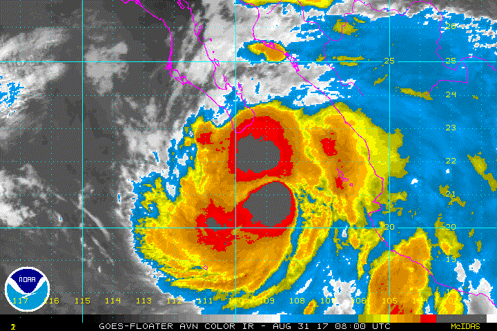
Convection looks angry.
Imagine the potential of Lidia if she's at 10 to 15N.
1 likes
The posts in this forum are NOT official forecast and should not be used as such. They are just the opinion of the poster and may or may not be backed by sound meteorological data. They are NOT endorsed by any professional institution or storm2k.org. For official information, please refer to RSMC, NHC and NWS products.

Re: EPAC: LIDIA - Tropical Storm
I agree, it looks like it is a huge rainmaker, hopefully we won't have bad news from Mexico.
0 likes

-
Kingarabian

- S2K Supporter

- Posts: 15432
- Joined: Sat Aug 08, 2009 3:06 am
- Location: Honolulu, Hawaii
Re: EPAC: LIDIA - Tropical Storm
000
WTPZ44 KNHC 312032
TCDEP4
Tropical Storm Lidia Discussion Number 9
NWS National Hurricane Center Miami FL EP142017
300 PM MDT Thu Aug 31 2017
Satellite imagery indicates that Lidia continues to become better
organized, with convective bands now wrapping most of the way
around a ragged clear-air center. Recent surface observations from
the Cabo San Lucas area support increasing the initial intensity to
55 kt, although it is unclear how much terrain enhancement of these
winds is occurring.
The initial motion is north-northwestward or 335/7 kt between a
mid-level anticyclone centered over central Mexico and a mid- to
upper-level low located to the west over the Pacific. This motion
should continue for the next 24 h or so. After that time, a
mid-level anticyclone over the southwestern United States should
become the main steering influence from 48-120 h, forcing Lidia to
turn northwestward and eventually westward. The guidance has become
somewhat less tightly spread, as the GFS is currently a right
outlier showing a motion into the northern Gulf of California.
Given the lack of support for this scenario from the other models,
the new forecast track is similar to the previous track and a little
south of the consensus models
Additional strengthening is possible this evening before the center
moves over the Baja California peninsula, and while the chance
of Lidia becoming a hurricane is low it is still non-zero.
Weakening is expected after 12 h due to the center moving up the
spine of the Baja California peninsula, but tropical-storm-force
winds are likely to spread up the Gulf of California well east of
the center. Lidia is forecast to become a remnant low by 72 h
due to interaction with land and cold water, and further weakening
is anticipated over the cold waters west of the northern Baja
California peninsula at 96 and 102 h.
Lidia is a large system accompanied by very heavy rains which are
already occurring over portions of western Mexico and Baja
California Sur. Regardless of how strong Lidia becomes,
life-threatening flash floods and mudslides will be a significant
hazard over these areas. In addition, the mountainous terrain of
the Baja California peninsula could enhance the winds at higher
elevations.
FORECAST POSITIONS AND MAX WINDS
INIT 31/2100Z 22.7N 110.1W 55 KT 65 MPH
12H 01/0600Z 23.8N 110.7W 60 KT 70 MPH
24H 01/1800Z 25.2N 111.7W 50 KT 60 MPH...INLAND
36H 02/0600Z 26.8N 113.0W 45 KT 50 MPH...INLAND
48H 02/1800Z 28.2N 114.4W 40 KT 45 MPH...OVER WATER
72H 03/1800Z 30.0N 117.0W 30 KT 35 MPH...POST-TROP/REMNT LOW
96H 04/1800Z 30.5N 120.0W 20 KT 25 MPH...POST-TROP/REMNT LOW
120H 05/1800Z 30.5N 123.0W 15 KT 15 MPH...POST-TROP/REMNT LOW
$$
Forecaster Beven
0 likes
RIP Kobe Bryant
-
Sciencerocks
- Category 5
- Posts: 7282
- Age: 38
- Joined: Thu Jul 06, 2017 1:51 am
Re: EPAC: LIDIA - Tropical Storm
Seems to be forming an eye on satellite this afternoon. I'd imagine that it could become a hurricane...
0 likes
Re: EPAC: LIDIA - Tropical Storm
Tropical Storm Lidia Discussion Number 12
NWS National Hurricane Center Miami FL EP142017
900 AM MDT Fri Sep 01 2017
Satellite imagery indicates that the center of Lidia has made
landfall on the Baja California peninsula west of La Paz. The
convective organization of the cyclone has decreased over the past
several hours and, based on this and continuity from the previous
advisory, the initial intensity is decreased to 50 kt. The storm
continues to have a large wind field in the eastern semicircle as
shown by a recent report of tropical-storm-force winds in Los
Mochis on the Mexican mainland.
The initial motion is 325/8. Lidia remains between a mid-level high
centered over the southwestern United States and a mid-level trough
southwest over the Pacific, and these features should keep Lidia on
a general northwestward course for the next three days. The new
forecast track has the center over or just off of the west coast of
the Baja California peninsula for the next 30-36 h before emerging
over the Pacific Ocean. Overall the new track is an update of the
previous track that lies close to the various consensus models.
Steady weakening is expected while the circulation interacts with
the mountainous terrain of Baja California. However, tropical-
storm-force winds will continue to extend well east of the center,
riding up the peninsula and adjacent Gulf of California for at least
the next 24 hours. When Lidia emerges over the Pacific, it is
expected to be over sea surface temperatures near or below 24C,
which should cause it to quickly decay to a remnant low. The new
intensity forecast is also an update of the previous forecast and
lies at the upper edge of the intensity guidance.
While Lidia should steadily weaken, the heavy rainfall threat will
continue over northwestern Mexico and the Baja California peninsula
during the next few days. Moisture from the cyclone could reach
the southwestern United States over the weekend.
FORECAST POSITIONS AND MAX WINDS
INIT 01/1500Z 24.6N 111.2W 50 KT 60 MPH...INLAND
12H 02/0000Z 25.8N 112.2W 45 KT 50 MPH...OVER WATER
24H 02/1200Z 27.4N 113.8W 40 KT 45 MPH...INLAND
36H 03/0000Z 28.6N 115.6W 35 KT 40 MPH...OVER WATER
48H 03/1200Z 29.9N 117.5W 30 KT 35 MPH...POST-TROP/REMNT LOW
72H 04/1200Z 32.5N 122.0W 20 KT 25 MPH...POST-TROP/REMNT LOW
96H 05/1200Z...DISSIPATED
$$
Forecaster Beven
0 likes
-
Sciencerocks
- Category 5
- Posts: 7282
- Age: 38
- Joined: Thu Jul 06, 2017 1:51 am
Re: EPAC: LIDIA - Tropical Storm
000
WTPZ44 KNHC 012035
TCDEP4
Tropical Storm Lidia Discussion Number 13
NWS National Hurricane Center Miami FL EP142017
300 PM MDT Fri Sep 01 2017
The center of Lidia has been moving over the southern portion of
the Baja California peninsula. While the convective cloud pattern
has become somewhat ragged, a recent surface observation from
Loreto, Mexico indicates that maximum sustained winds remain near
50 kt. The storm also continues to have a large wind field in the
eastern semicircle as shown by a prolonged period of tropical-
storm-force winds at Los Mochis on the Mexican mainland.
Weakening is expected while the circulation interacts with the
mountainous terrain of Baja California. However, tropical-storm-
force winds will continue to extend well east of the center, riding
up the peninsula and adjacent Gulf of California for about the
next 24 hours. When Lidia emerges over the Pacific, it is expected
to be over sea surface temperatures near or below 24C, which should
cause it to quickly decay to a remnant low. The latest large-scale
model guidance suggests that a circulation should persist through
96 h, possibly due to interaction with a nearby mid- to upper-level
low late in the forecast period. Thus, a 96 h point has been
included.
The initial motion is now 325/10. Lidia remains between a mid-level
high centered over the southwestern United States and the
aforementioned mid- to upper-level trough to the southwest and south
over the Pacific, and these features should keep the cyclone on a
general northwestward course for the next 72 h or so, followed by a
turn toward the west-northwest. The new forecast track has the
center over or just off of the west coast of the Baja California
peninsula for the next 18-24 h before emerging over the Pacific
Ocean. Overall the new track is an update of the previous track that
lies close to, but is slightly faster than, the various consensus
models.
While Lidia should weaken, the heavy rainfall threat will continue
over northwestern Mexico and the Baja California peninsula during
the next few days. Moisture from the cyclone could reach the
southwestern United States over the weekend.
FORECAST POSITIONS AND MAX WINDS
INIT 01/2100Z 25.5N 111.9W 50 KT 60 MPH...INLAND
12H 02/0600Z 26.8N 113.0W 45 KT 50 MPH...INLAND
24H 02/1800Z 28.2N 114.6W 35 KT 40 MPH...OVER WATER
36H 03/0600Z 29.4N 116.4W 30 KT 35 MPH...POST-TROP/REMNT LOW
48H 03/1800Z 30.7N 118.3W 25 KT 30 MPH...POST-TROP/REMNT LOW
72H 04/1800Z 33.0N 123.0W 20 KT 25 MPH...POST-TROP/REMNT LOW
96H 05/1800Z 34.0N 127.0W 20 KT 25 MPH...POST-TROP/REMNT LOW
120H 06/1800Z...DISSIPATED
$$
Forecaster Beven
0 likes
-
cycloneye
- Admin
- Posts: 139021
- Age: 67
- Joined: Thu Oct 10, 2002 10:54 am
- Location: San Juan, Puerto Rico
Re: EPAC: LIDIA - Tropical Depression
Tropical Depression Lidia Discussion Number 18
NWS National Hurricane Center Miami FL EP142017
800 PM PDT Sat Sep 02 2017
Lidia continues to weaken over the very cold waters of the
northeastern Pacific. There have been no recent reports of
sustained winds above 30 kt, so Lidia is now classified as a 30-kt
depression, in agreement with the Dvorak current intensity estimate
from TAFB. Deep convection is limited to a broken band displaced
about 120 n mi to the northeast of the low-level center. Assuming
this convective trend continues, Lidia will likely become a remnant
low overnight. After becoming post-tropical, the global models are
in good agreement that the circulation of Lidia should continue to
gradually spin down over the course of a day or two, before
dissipating in about 48 h.
A recent SSMIS overpass indicates that the low-level circulation
is somewhat ill defined and located nearly a degree to the west of
our previous center estimate. The initial position and subsequent
track forecast has been shifted in that direction, but not quite as
far as the microwave data would suggest, given the uncertainty
associated with that fix. Regardless of the exact center position,
Lidia is still expected to continue generally west-northwestward to
northwestward for the next 24-36 h along the southwest periphery of
a mid-level ridge located over the southwestern U.S.
FORECAST POSITIONS AND MAX WINDS
INIT 03/0300Z 29.0N 115.8W 30 KT 35 MPH
12H 03/1200Z 29.9N 117.2W 25 KT 30 MPH...POST-TROP/REMNT LOW
24H 04/0000Z 31.0N 119.1W 20 KT 25 MPH...POST-TROP/REMNT LOW
36H 04/1200Z 31.7N 121.2W 20 KT 25 MPH...POST-TROP/REMNT LOW
48H 05/0000Z...DISSIPATED
$$
Forecaster Zelinsky
0 likes
Visit the Caribbean-Central America Weather Thread where you can find at first post web cams,radars
and observations from Caribbean basin members Click Here
and observations from Caribbean basin members Click Here
-
bob rulz
- Category 5
- Posts: 1667
- Age: 34
- Joined: Sat Jan 28, 2006 7:30 pm
- Location: Salt Lake City, Utah
Re: EPAC: LIDIA - Tropical Depression
At least 5 deaths so far from this storm. Seems like a big rain producer.
https://www.wunderground.com/news/poten ... -los-cabos
https://www.wunderground.com/news/poten ... -los-cabos
0 likes
Re: EPAC: LIDIA - Post-Tropical
Death toll updated to 6. It seems like some locations got heavy damages from flooding and ladnslides:
https://translate.google.com/translate?sl=es&tl=en&js=y&prev=_t&hl=es&ie=UTF-8&u=http%3A%2F%2Fwww.excelsior.com.mx%2Fnacional%2F2017%2F09%2F03%2F1185845&edit-text=
https://translate.google.com/translate?sl=es&tl=en&js=y&prev=_t&hl=es&ie=UTF-8&u=http%3A%2F%2Fwww.excelsior.com.mx%2Fnacional%2F2017%2F09%2F03%2F1185845&edit-text=
0 likes
Who is online
Users browsing this forum: No registered users and 32 guests