AL, 95, 2017090500, , BEST, 0, 217N, 962W, 25, 1010, DB
Thread at Talking Tropics forum that was the topic for this BOC disturbance.
viewtopic.php?f=31&t=119112
8 PM TWO:
A trough of low pressure located over the southwestern Gulf of
Mexico is producing disorganized showers activity and gusty winds.
Environmental conditions are marginally conducive for slow
development, and this system could become a tropical depression
during the next couple of days while it meanders over the
southwestern Gulf of Mexico during the next few days.
* Formation chance through 48 hours...medium...50 percent.
* Formation chance through 5 days...medium...60 percent.
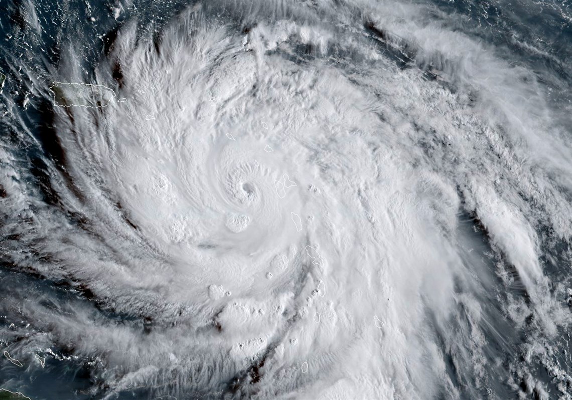
ATL: KATIA - Hurricane - Discussion
Moderator: S2k Moderators
-
cycloneye

- Admin

- Posts: 139042
- Age: 67
- Joined: Thu Oct 10, 2002 10:54 am
- Location: San Juan, Puerto Rico
ATL: KATIA - Hurricane - Discussion
0 likes
Visit the Caribbean-Central America Weather Thread where you can find at first post web cams,radars
and observations from Caribbean basin members Click Here
and observations from Caribbean basin members Click Here
-
CrazyC83
- Professional-Met

- Posts: 33393
- Joined: Tue Mar 07, 2006 11:57 pm
- Location: Deep South, for the first time!
Re: ATL: INVEST 95L - Discussion
I wonder - could this play a role in the ultimate evolution of Irma, either by opening a path west, or by extending the trough's reach to amplify a turn?
2 likes

Re: ATL: INVEST 95L - Discussion
Pressure dropping pretty quickly.
https://ibb.co/fvXXbv
https://ibb.co/fvXXbv
1 likes
The following post is NOT an official forecast and should not be used as such. It is just the opinion of the poster and may or may not be backed by sound meteorological data. It is NOT endorsed by any professional institution including storm2k.org For Official Information please refer to the NHC and NWS products.
Re: ATL: INVEST 95L - Discussion
REally think if this does form, it will draw Irma further West.
0 likes
Personal Forecast Disclaimer:
The posts in this forum are NOT official forecast and should not be used as such. They are just the opinion of the poster and may or may not be backed by sound meteorological data. They are NOT endorsed by any professional institution or storm2k.org. For official information, please refer to the NHC and NWS products.
The posts in this forum are NOT official forecast and should not be used as such. They are just the opinion of the poster and may or may not be backed by sound meteorological data. They are NOT endorsed by any professional institution or storm2k.org. For official information, please refer to the NHC and NWS products.

Re: ATL: INVEST 95L - Discussion
Glad to see an invest, finally. Feel like I've been watching the area for a few days.
That is not something I even want to consider. Ugh.
Blinhart wrote:REally think if this does form, it will draw Irma further West.
That is not something I even want to consider. Ugh.
0 likes

Re: ATL: INVEST 95L - Discussion
CrazyC83 wrote:I wonder - could this play a role in the ultimate evolution of Irma, either by opening a path west, or by extending the trough's reach to amplify a turn?
A turn would away from the Gulf of Mexico would be much better.
0 likes
-
cycloneye
- Admin
- Posts: 139042
- Age: 67
- Joined: Thu Oct 10, 2002 10:54 am
- Location: San Juan, Puerto Rico
Re: ATL: INVEST 95L - Discussion
8 AM TWO:
. A trough of low pressure located over the southwestern Gulf of
Mexico is producing numerous showers and thunderstorms.
Environmental conditions are conducive for gradual development, and
this system is likely to become a tropical depression during the
next couple of days while it meanders over the southwestern Gulf of
Mexico. Regardless of development, heavy rains associated with this
disturbance are likely over portions of eastern Mexico during the
remainder of the week.
* Formation chance through 48 hours...medium...60 percent.
* Formation chance through 5 days...high...70 percent.
0 likes
Visit the Caribbean-Central America Weather Thread where you can find at first post web cams,radars
and observations from Caribbean basin members Click Here
and observations from Caribbean basin members Click Here
-
lovingseason2013
- Tropical Depression

- Posts: 54
- Joined: Sat Oct 12, 2013 7:54 am
- Location: Pensacola, FL
Re: ATL: INVEST 95L - Discussion
Have any models picked up on this yet, so as we might know where it could be headed? Or is it going into Mexico already?
1 likes
-
MGC

- S2K Supporter

- Posts: 5792
- Joined: Sun Mar 23, 2003 9:05 pm
- Location: Pass Christian MS, or what is left.
Re: ATL: INVEST 95L - Discussion
A lot of convection is building down in the BOC this morning. Looks like 95L is slowly organizing.....MGC
0 likes
-
Portastorm

- Storm2k Moderator

- Posts: 9787
- Age: 61
- Joined: Fri Jul 11, 2003 9:16 am
- Location: South Austin, TX
- Contact:
ATL: KATIA - Models
First blush:

0 likes
Any forecasts under my name are to be taken with a grain of salt. Get your best forecasts from the National Weather Service and National Hurricane Center.
I'm a certified Advanced SKYWARN-trained spotter and am active on Twitter at @TravisCOSW, a social media partner of the NWS Austin-San Antonio office.
I'm a certified Advanced SKYWARN-trained spotter and am active on Twitter at @TravisCOSW, a social media partner of the NWS Austin-San Antonio office.
-
Stormcenter
- S2K Supporter
- Posts: 6617
- Joined: Wed Sep 03, 2003 11:27 am
- Location: Houston, TX
Re: ATL: INVEST 95L - Discussion
More like rapidly organizing.
MGC wrote:A lot of convection is building down in the BOC this morning. Looks like 95L is slowly organizing.....MGC
0 likes
-
Hurricaneman

- Category 5

- Posts: 7280
- Age: 43
- Joined: Tue Aug 31, 2004 3:24 pm
- Location: central florida
Re: ATL: INVEST 95L - Discussion
Stormcenter wrote:More like rapidly organizing.MGC wrote:A lot of convection is building down in the BOC this morning. Looks like 95L is slowly organizing.....MGC
I have a feeling we will have Katia sometime tomorrow and this may be a piece of the Irma puzzle in terms of track
0 likes
-
Portastorm
- Storm2k Moderator
- Posts: 9787
- Age: 61
- Joined: Fri Jul 11, 2003 9:16 am
- Location: South Austin, TX
- Contact:
Re: ATL: INVEST 95L - Models

0 likes
Any forecasts under my name are to be taken with a grain of salt. Get your best forecasts from the National Weather Service and National Hurricane Center.
I'm a certified Advanced SKYWARN-trained spotter and am active on Twitter at @TravisCOSW, a social media partner of the NWS Austin-San Antonio office.
I'm a certified Advanced SKYWARN-trained spotter and am active on Twitter at @TravisCOSW, a social media partner of the NWS Austin-San Antonio office.
-
cycloneye
- Admin
- Posts: 139042
- Age: 67
- Joined: Thu Oct 10, 2002 10:54 am
- Location: San Juan, Puerto Rico
Re: ATL: INVEST 95L - Discussion
2 PM TWO up to 70%/80%
A well-defined area of low pressure has formed about 50 miles east
of Tampico, Mexico in the southwestern Gulf of Mexico in
association with numerous showers and thunderstorms. Environmental
conditions are conducive for gradual development, and
this system is likely to become a tropical depression during the
next couple of days while it meanders over the southwestern Gulf of
Mexico. Regardless of development, heavy rains associated with this
disturbance are likely over portions of eastern Mexico during the
remainder of the week.
* Formation chance through 48 hours...high...70 percent.
* Formation chance through 5 days...high...80 percent.
0 likes
Visit the Caribbean-Central America Weather Thread where you can find at first post web cams,radars
and observations from Caribbean basin members Click Here
and observations from Caribbean basin members Click Here
-
HurricaneA
- Tropical Low

- Posts: 12
- Age: 24
- Joined: Sat Jun 04, 2016 5:52 pm
- Location: Bryan, TX
Re: ATL: INVEST 95L - Discussion
Since 95L has a high chance of developing, will the NHC start initiating advisories for PTC 13 at the 5 PM update?
0 likes

Re: ATL: INVEST 95L - Discussion
Katia will literally have 0 impact on Irma sadly, they are being guided by two totally different steering currents.
Anyway, 95L is looking decent and I strongly suspect it will beocme Katia sooner rather than later, especially as this part of the basin has been a hot spot recent years.
Anyway, 95L is looking decent and I strongly suspect it will beocme Katia sooner rather than later, especially as this part of the basin has been a hot spot recent years.
0 likes
Personal Forecast Disclaimer:
The posts in this forum are NOT official forecast and should not be used as such. They are just the opinion of the poster and may or may not be backed by sound meteorological data. They are NOT endorsed by any professional institution or storm2k.org. For official information, please refer to the NHC and NWS products
The posts in this forum are NOT official forecast and should not be used as such. They are just the opinion of the poster and may or may not be backed by sound meteorological data. They are NOT endorsed by any professional institution or storm2k.org. For official information, please refer to the NHC and NWS products
Re: ATL: INVEST 95L - Discussion
Quick question.. Why do some models have this disturbance heading north towards the central gulf coast and other models have it going west into Mexico? (And other models don't show it at all..)
0 likes
-
Portastorm
- Storm2k Moderator
- Posts: 9787
- Age: 61
- Joined: Fri Jul 11, 2003 9:16 am
- Location: South Austin, TX
- Contact:
Re: ATL: INVEST 95L - Discussion
smw1981 wrote:Quick question.. Why do some models have this disturbance heading north towards the central gulf coast and other models have it going west into Mexico? (And other models don't show it at all..)
I have not seen one model showing a track north towards the central Gulf coast outside of one solitary Navgem run from 12z. Which models are you talking about?
0 likes
Any forecasts under my name are to be taken with a grain of salt. Get your best forecasts from the National Weather Service and National Hurricane Center.
I'm a certified Advanced SKYWARN-trained spotter and am active on Twitter at @TravisCOSW, a social media partner of the NWS Austin-San Antonio office.
I'm a certified Advanced SKYWARN-trained spotter and am active on Twitter at @TravisCOSW, a social media partner of the NWS Austin-San Antonio office.
-
Portastorm
- Storm2k Moderator
- Posts: 9787
- Age: 61
- Joined: Fri Jul 11, 2003 9:16 am
- Location: South Austin, TX
- Contact:
Re: ATL: INVEST 95L - Models

0 likes
Any forecasts under my name are to be taken with a grain of salt. Get your best forecasts from the National Weather Service and National Hurricane Center.
I'm a certified Advanced SKYWARN-trained spotter and am active on Twitter at @TravisCOSW, a social media partner of the NWS Austin-San Antonio office.
I'm a certified Advanced SKYWARN-trained spotter and am active on Twitter at @TravisCOSW, a social media partner of the NWS Austin-San Antonio office.
-
galaxy401

- Category 5
- Posts: 2299
- Age: 28
- Joined: Sat Aug 25, 2012 9:04 pm
- Location: Casa Grande, Arizona
Re: ATL: THIRTEEN - Tropical Depression - Discussion
And yet another one!
BULLETIN
Tropical Depression Thirteen Advisory Number 1
NWS National Hurricane Center Miami FL AL132017
400 PM CDT Tue Sep 05 2017
...DEPRESSION FORMS IN THE SOUTHWESTERN GULF OF MEXICO...
...EXPECTED TO MOVE LITTLE OVER THE NEXT FEW DAYS...
SUMMARY OF 400 PM CDT...2100 UTC...INFORMATION
----------------------------------------------
LOCATION...22.4N 96.7W
ABOUT 80 MI...125 KM E OF TAMPICO MEXICO
MAXIMUM SUSTAINED WINDS...35 MPH...55 KM/H
PRESENT MOVEMENT...E OR 90 DEGREES AT 2 MPH...4 KM/H
MINIMUM CENTRAL PRESSURE...1008 MB...29.77 INCHES
0 likes
Got my eyes on moving right into Hurricane Alley: Florida.
Who is online
Users browsing this forum: No registered users and 46 guests