EPAC: MAX - Remnants

Moderator: S2k Moderators

Message
Author
User avatar
Extratropical94
Professional-Met
Professional-Met
Posts: 3535
Age: 29
Joined: Wed Oct 20, 2010 6:36 am
Location: Hamburg, Germany
Contact:

Re: EPAC: MAX - Tropical Storm

#21 Postby Extratropical94 » Thu Sep 14, 2017 4:09 am

Tropical Storm Max Discussion Number 4
NWS National Hurricane Center Miami FL EP162017
400 AM CDT Thu Sep 14 2017

We have good data this morning. Very useful radar images from
Mexico show that Max's structure has improved during the past few
hours. An excellent ASCAT pass over the system was helpful in
determining the intensity and the tropical-storm-force wind radii.
Furthermore, the ship A8MW6 reported 45 kt winds and 11 foot waves
near the coast of Mexico. Based on these data, the initial intensity
was adjusted to 55 kt. At this point, it would only take a small
increase in intensity for Max to reach the coast as a hurricane.
Once the center moves inland the cyclone is forecast to weaken
quickly and dissipate within 36 hours.

Max is moving toward the east-northeast or 070 degrees at 5 kt. The
storm is embedded within a west-southwest flow and this flow
pattern will steer Max toward Mexico until dissipation. Based on
the forecast track, the core should be inland within the warning
area within the next 12 hours.

Max will produce life-threatening flooding rainfall in portions of
the states of Guerrero and Oaxaca.


FORECAST POSITIONS AND MAX WINDS

INIT 14/0900Z 16.6N 100.5W 55 KT 65 MPH
12H 14/1800Z 16.9N 99.7W 60 KT 70 MPH...INLAND
24H 15/0600Z 17.0N 99.0W 35 KT 40 MPH...INLAND
36H 15/1800Z...DISSIPATED

$$
Forecaster Avila
0 likes   
54° 11' 59'' N, 9° 9' 20'' E
Boomer Sooner!
Go Broncos! Go Cards! Go Niners!
- Daniel

User avatar
Extratropical94
Professional-Met
Professional-Met
Posts: 3535
Age: 29
Joined: Wed Oct 20, 2010 6:36 am
Location: Hamburg, Germany
Contact:

Re: EPAC: MAX - Tropical Storm

#22 Postby Extratropical94 » Thu Sep 14, 2017 7:09 am

Wow, another example of a storm rapidly intensifying before landfall.

Hurricane Max Special Discussion Number 5
NWS National Hurricane Center Miami FL EP162017
700 AM CDT Thu Sep 14 2017

Radar imagery from Acapulco, Mexico, indicates that Max has
continued to improve in structure and now has a well-defined eye
and closed eyewall. An eye has also occasionally been evident in
infrared satellite imagery. Based on these signs, Max has been
upgraded to a hurricane with 65-kt winds.

Max appears to be cruising eastward just offshore the coast of
Mexico. However, the hurricane is still expected to move inland
later today. The 12-hour point has been adjusted southward and
increased to 75 kt to account for Max's recent motion, possible
delayed landfall, and increased opportunity to strengthen before it
reaches land.

The government of Mexico has changed the Tropical Storm Warning and
Hurricane Watch from Zihuatanejo to Punta Maldonado to a Hurricane
Warning. Life-threatening flooding rainfall is still expected in
portions of the states of Guerrero and Oaxaca.

This special advisory is being issued in lieu of the regularly
scheduled 7 AM CDT intermediate public advisory.

FORECAST POSITIONS AND MAX WINDS

INIT 14/1200Z 16.3N 100.4W 65 KT 75 MPH
12H 14/1800Z 16.6N 99.7W 75 KT 85 MPH
24H 15/0600Z 16.8N 99.0W 35 KT 40 MPH...INLAND
36H 15/1800Z...DISSIPATED
0 likes   
54° 11' 59'' N, 9° 9' 20'' E
Boomer Sooner!
Go Broncos! Go Cards! Go Niners!
- Daniel

CrazyC83
Professional-Met
Professional-Met
Posts: 33393
Joined: Tue Mar 07, 2006 11:57 pm
Location: Deep South, for the first time!

Re: EPAC: MAX - Hurricane

#23 Postby CrazyC83 » Thu Sep 14, 2017 7:55 am

Will it deepen right up to landfall, or will land interaction and dry air set it back?
0 likes   

User avatar
Yellow Evan
Professional-Met
Professional-Met
Posts: 15951
Age: 25
Joined: Fri Jul 15, 2011 12:48 pm
Location: Henderson, Nevada/Honolulu, HI
Contact:

Re: EPAC: MAX - Hurricane

#24 Postby Yellow Evan » Thu Sep 14, 2017 8:56 am

* EAST PACIFIC SHIPS INTENSITY FORECAST *
* IR SAT DATA PROXY USED, OHC AVAILABLE *
* MAX EP162017 09/14/17 12 UTC *

TIME (HR) 0 6 12 18 24 36 48 60 72 84 96 108 120
V (KT) NO LAND 70 77 80 81 81 79 77 74 72 71 69 67 67
V (KT) LAND 70 77 69 57 47 36 31 28 27 27 27 27 27
V (KT) LGEM 70 78 84 61 50 DIS DIS DIS DIS DIS DIS DIS DIS
Storm Type TROP TROP TROP TROP TROP N/A N/A N/A N/A N/A N/A N/A N/A

SHEAR (KT) 9 11 12 17 17 N/A N/A N/A N/A N/A N/A N/A N/A
SHEAR ADJ (KT) 2 1 -1 -4 -2 N/A N/A N/A N/A N/A N/A N/A N/A
SHEAR DIR 9 356 353 356 17 N/A N/A N/A N/A N/A N/A N/A N/A
SST (C) 29.9 29.9 30.0 30.0 30.0 N/A N/A N/A N/A N/A N/A N/A N/A
POT. INT. (KT) 162 162 162 162 162 N/A N/A N/A N/A N/A N/A N/A N/A
200 MB T (C) -52.8 -52.4 -51.9 -52.1 -52.0 N/A N/A N/A N/A N/A N/A N/A N/A
200 MB VXT (C) 0.1 0.0 0.0 -0.2 -0.1 N/A N/A N/A N/A N/A N/A N/A N/A
TH_E DEV (C) 6 9 11 9 8 N/A N/A N/A N/A N/A N/A N/A N/A
700-500 MB RH 65 60 59 60 61 N/A N/A N/A N/A N/A N/A N/A N/A
MODEL VTX (KT) 6 4 3 3 3 LOST LOST LOST LOST LOST LOST LOST LOST
850 MB ENV VOR -22 -21 -14 -17 -8 N/A N/A N/A N/A N/A N/A N/A N/A
200 MB DIV 66 57 74 52 23 N/A N/A N/A N/A N/A N/A N/A N/A
700-850 TADV -1 -1 0 0 0 N/A N/A N/A N/A N/A N/A N/A N/A
LAND (KM) 66 31 -3 -21 -39 N/A N/A N/A N/A N/A N/A N/A N/A
LAT (DEG N) 16.3 16.5 16.6 16.7 16.7 N/A N/A N/A N/A N/A N/A N/A N/A
LONG(DEG W) 100.2 99.8 99.3 99.0 98.7 N/A N/A N/A N/A N/A N/A N/A N/A
STM SPEED (KT) 4 5 4 3 3 N/A N/A N/A N/A N/A N/A N/A N/A
HEAT CONTENT 26 22 12 50 52 0 0 0 0 0 0 0 0

FORECAST TRACK FROM OFCI INITIAL HEADING/SPEED (DEG/KT): 85/ 5 CX,CY: 5/ 0
T-12 MAX WIND: 45 PRESSURE OF STEERING LEVEL (MB): 574 (MEAN=550)
GOES IR BRIGHTNESS TEMP. STD DEV. 50-200 KM RAD: 12.8 (MEAN=14.5)
% GOES IR PIXELS WITH T < -20 C 50-200 KM RAD: 100.0 (MEAN=65.0)
PRELIM RI PROB (DV .GE. 55 KT IN 48 HR): 8.4

INDIVIDUAL CONTRIBUTIONS TO INTENSITY CHANGE
6 12 18 24 36 48 60 72 84 96 108 120
----------------------------------------------------------
SAMPLE MEAN CHANGE 0. 0. 1. 1. 1. 1. 1. 1. -0. -1. -1. -2.
SST POTENTIAL 1. 2. 3. 4. 6. 5. 4. 3. 2. 0. -0. 1.
VERTICAL SHEAR MAG -0. -1. -2. -3. -3. -3. -2. -2. -1. -1. -1. -2.
VERTICAL SHEAR ADJ -0. -0. 0. 0. 0. 0. 0. 0. 0. 0. 0. 0.
VERTICAL SHEAR DIR 0. -0. -0. -0. -0. -0. -0. -0. -0. -0. -1. -1.
PERSISTENCE 6. 9. 10. 10. 8. 6. 4. 2. 1. -0. -2. -3.
200/250 MB TEMP. -0. -0. -0. -1. -1. -2. -4. -5. -6. -6. -6. -6.
THETA_E EXCESS 0. 1. 1. 1. 2. 3. 4. 5. 6. 7. 7. 8.
700-500 MB RH 0. -0. -0. -0. -0. -0. -0. -0. -0. -0. -0. 0.
MODEL VTX TENDENCY -0. -1. -2. -2. -3. -3. -3. -3. -3. -3. -3. -3.
850 MB ENV VORTICITY 0. 0. 0. 0. 0. 1. 1. 1. 2. 2. 2. 2.
200 MB DIVERGENCE 0. 0. 1. 1. 1. 1. 1. 1. 1. 1. 1. 1.
850-700 T ADVEC -0. 0. -0. -0. 0. 0. 0. 0. 0. 0. 0. 0.
ZONAL STORM MOTION -1. -1. -2. -3. -5. -6. -6. -5. -4. -4. -3. -4.
STEERING LEVEL PRES 0. 0. 0. 0. 0. 0. 0. 0. 0. 0. 0. 0.
DAYS FROM CLIM. PEAK 0. 0. 0. 0. -0. 0. 0. 0. 1. 1. 1. 1.
GOES PREDICTORS 1. 1. 1. 1. 2. 2. 3. 3. 3. 3. 3. 3.
OCEAN HEAT CONTENT 0. 0. 0. 1. 0. -0. -0. -0. -0. -0. -0. 0.
----------------------------------------------------------
TOTAL CHANGE 7. 10. 11. 11. 9. 7. 4. 2. 1. -1. -3. -3.

CURRENT MAX WIND (KT): 70. LAT, LON: 16.3 100.2

** 2017 E.PACIFIC RI INDEX EP162017 MAX 09/14/17 12 UTC **
(SHIPS-RII PREDICTOR TABLE for 30 KT OR MORE MAXIMUM WIND INCREASE IN NEXT 24-h)

Predictor Value RI Predictor Range Scaled Value(0-1) % Contribution
12 HR PERSISTENCE (KT): 25.0 -22.0 to 44.0 0.71 999.0
POT = MPI-VMAX (KT) : 91.8 40.5 to 149.3 0.47 999.0
850-200 MB SHEAR (KT) : 13.2 18.9 to 1.4 0.33 999.0
HEAT CONTENT (KJ/cm2) : 32.4 0.0 to 106.7 0.30 999.0
MAXIMUM WIND (kt) : 70.0 22.5 to 132.0 0.83 999.0
D200 (10**7s-1) : 54.4 -33.0 to 156.2 0.46 999.0
STD DEV OF IR BR TEMP : 999.0 37.8 to 2.1 999.00 999.0
% AREA WITH TPW <45 mm: 11.6 62.3 to 0.0 0.81 999.0
2nd PC OF IR BR TEMP : 1.0 2.2 to -1.9 0.30 999.0
BL DRY-AIR FLUX (w/m2): 352.4 735.9 to -82.5 0.47 999.0

SHIPS Prob RI for 20kt/ 12hr RI threshold= 999% is 999.0 times sample mean ( 7.7%)
SHIPS Prob RI for 25kt/ 24hr RI threshold= 999% is 999.0 times sample mean (15.3%)
SHIPS Prob RI for 30kt/ 24hr RI threshold= 999% is 999.0 times sample mean (10.4%)
SHIPS Prob RI for 35kt/ 24hr RI threshold= 999% is 999.0 times sample mean ( 7.5%)
SHIPS Prob RI for 40kt/ 24hr RI threshold= 999% is 999.0 times sample mean ( 5.2%)
SHIPS Prob RI for 45kt/ 36hr RI threshold= 999% is 999.0 times sample mean ( 8.1%)
SHIPS Prob RI for 55kt/ 48hr RI threshold= 999% is 999.0 times sample mean ( 7.4%)
SHIPS Prob RI for 65kt/ 72hr RI threshold= 999% is 999.0 times sample mean ( 5.5%)

Matrix of RI probabilities
------------------------------------------------------------------------------
RI (kt / h) | 20/12 | 25/24 | 30/24 | 35/24 | 40/24 | 45/36 | 55/48 |65/72
------------------------------------------------------------------------------
SHIPS-RII: 999.0% 999.0% 999.0% 999.0% 999.0% 999.0% 999.0% 999.0%
Logistic: 999.0% 999.0% 999.0% 999.0% 999.0% 999.0% 999.0% 999.0%
Bayesian: 999.0% 999.0% 999.0% 999.0% 999.0% 999.0% 999.0% 999.0%
Consensus: 999.0% 999.0% 999.0% 999.0% 999.0% 999.0% 999.0% 999.0%

## ANNULAR HURRICANE INDEX (AHI) EP162017 MAX 09/14/17 12 UTC ##
## STORM NOT ANNULAR, SCREENING STEP FAILED, NPASS=3 NFAIL=4 ##
## AHI= 0 (AHI OF 100 IS BEST FIT TO ANN. STRUC., 1 IS MARGINAL, 0 IS NOT ANNULAR) ##
0 likes   

User avatar
Yellow Evan
Professional-Met
Professional-Met
Posts: 15951
Age: 25
Joined: Fri Jul 15, 2011 12:48 pm
Location: Henderson, Nevada/Honolulu, HI
Contact:

Re: EPAC: MAX - Hurricane

#25 Postby Yellow Evan » Thu Sep 14, 2017 10:52 am

ZCZC MIATCDEP1 ALL
TTAA00 KNHC DDHHMM

Hurricane Max Discussion Number 6
NWS National Hurricane Center Miami FL EP162017
1000 AM CDT Thu Sep 14 2017

Max continues to have a well-defined eye in radar imagery from
Acapulco, Mexico, even though the eye that was observed in earlier
infrared satellite imagery has become obscured. Dvorak intensity
estimates from TAFB and SAB are up to T4.0/65 kt, but given the
hurricane's structure as seen in radar data, the initial intensity
is set slightly higher at 70 kt.

Radar animations indicate that Max's eye has been moving just north
of due east, and the initial motion is estimated to be 085/5 kt.
Max is located to the north of a mid-level ridge extending
southwest of Guatemala, and the flow around this ridge should force
the hurricane to move eastward or east-northeastward across the
coast of Guerrero or Oaxaca by this evening or tonight. After
landfall, Max should move farther inland over southern Mexico.

With sea surface temperatures near 30 degrees Celsius and relatively
low shear, the environment appears conducive for further
strengthening before Max reaches the coast. The new NHC forecast
closely follows the SHIPS and LGEM statistical-dynamical guidance
and shows a little more intensification during the next 12 hours
than was indicated in the previous advisory. Max will weaken
quickly after landfall, and is expected to dissipate over the
mountainous terrain of southern Mexico by 36 hours.

Heavy rainfall continues to be the primary threat from Max.
Rainfall accumulations of 5 to 10 inches, with isolated amounts of
20 inches, are expected over the Mexican states of Guerrero and
Oaxaca, and life-threatening flash floods and mudslides are
possible.

FORECAST POSITIONS AND MAX WINDS

INIT 14/1500Z 16.3N 99.9W 70 KT 80 MPH
12H 15/0000Z 16.5N 99.1W 80 KT 90 MPH
24H 15/1200Z 16.9N 98.1W 45 KT 50 MPH...INLAND
36H 16/0000Z...DISSIPATED

$$
Forecaster Berg

NNNN
0 likes   

Sciencerocks
Category 5
Category 5
Posts: 7282
Age: 38
Joined: Thu Jul 06, 2017 1:51 am

Re: EPAC: MAX - Hurricane

#26 Postby Sciencerocks » Thu Sep 14, 2017 2:48 pm

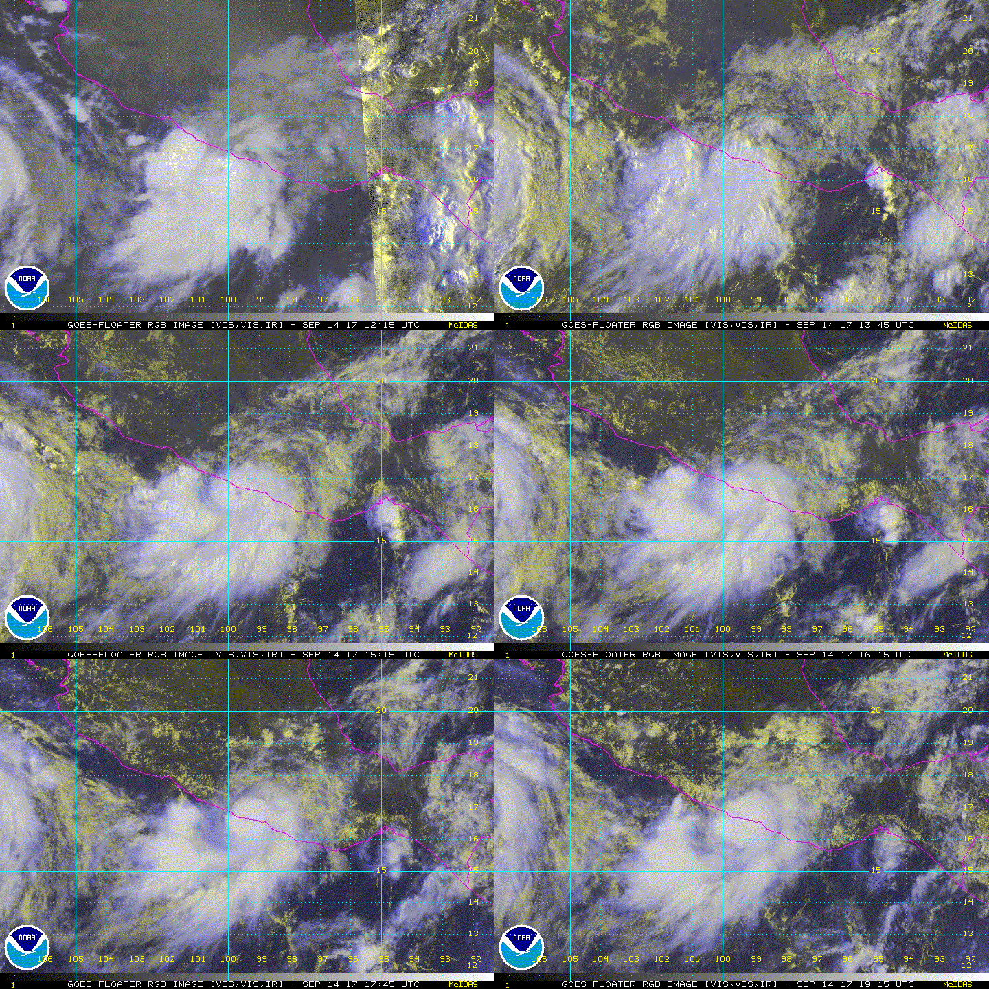
Looks like the eye made landfall. I'd estimate probably around 80 knots as that is a very well defined eye.

Image
2 likes   

User avatar
Yellow Evan
Professional-Met
Professional-Met
Posts: 15951
Age: 25
Joined: Fri Jul 15, 2011 12:48 pm
Location: Henderson, Nevada/Honolulu, HI
Contact:

Re: EPAC: MAX - Hurricane

#27 Postby Yellow Evan » Thu Sep 14, 2017 10:30 pm

ZCZC MIATCDEP1 ALL
TTAA00 KNHC DDHHMM

Tropical Storm Max Discussion Number 8
NWS National Hurricane Center Miami FL EP162017
1000 PM CDT Thu Sep 14 2017

The center of Max has continued to move inland over southern Mexico
since the previous advisory. The satellite and radar presentation
has degraded significantly during the past few hours and the
initial intensity has been lowered to 40 kt for this advisory.
Rapid weakening is expected overnight while Max moves farther
inland, and the small tropical cyclone is expected to dissipate
over the high terrain of southern Mexico early Friday.

The initial motion estimate is 085/6 kt. Max is being steered
eastward around the north side of a mid-level ridge that extends
southwestward from Central America. The cyclone should continue
moving on this general heading and speed until dissipation occurs
on Friday.

The primary threat from Max is heavy rainfall and flooding over
portions of southern Mexico. Rainfall accumulations of 5 to 10
inches, with isolated amounts of 20 inches, are expected over the
Mexican states of Guerrero and Oaxaca, and life-threatening flash
floods and mudslides are possible.


FORECAST POSITIONS AND MAX WINDS

INIT 15/0300Z 16.8N 98.5W 40 KT 45 MPH
12H 15/1200Z 16.8N 97.7W 25 KT 30 MPH...POST-TROP/REMNT LOW
24H 16/0000Z...DISSIPATED

$$
Forecaster Brown

NNNN
0 likes   

User avatar
Yellow Evan
Professional-Met
Professional-Met
Posts: 15951
Age: 25
Joined: Fri Jul 15, 2011 12:48 pm
Location: Henderson, Nevada/Honolulu, HI
Contact:

Re: EPAC: MAX - Remnants

#28 Postby Yellow Evan » Fri Sep 15, 2017 8:34 am

000
WTPZ41 KNHC 150836
TCDEP1

Remnants Of Max Discussion Number 9
NWS National Hurricane Center Miami FL EP162017
400 AM CDT Fri Sep 15 2017

The high terrain of Mexico has disrupted Max's circulation and the
system has degenerated into a broad area of low pressure. Surface
observations indicate that winds associated with the low are
barely 25 kt. The remnants of Max will probably continue moving
slowly eastward until dissipation later today.

The remnants of Max are still expected to produce heavy rain in
the states of Guerrero and Oaxaca.

This is the last advisory issued by the National Hurricane Center
on Max.


FORECAST POSITIONS AND MAX WINDS

INIT 15/0900Z 17.0N 98.0W 25 KT 30 MPH...REMNANTS OF MAX
12H 15/1800Z 17.5N 97.5W 20 KT 25 MPH...REMNANTS OF MAX
24H 16/0600Z...DISSIPATED

$$
0 likes   


Return to “2017”

Who is online

Users browsing this forum: No registered users and 86 guests