ATL: MARIA - Post-Tropical - Discussion

Moderator: S2k Moderators

Message
Author
Vdogg
Category 2
Category 2
Posts: 619
Joined: Wed Aug 31, 2016 9:56 am

Re: ATL: MARIA - Hurricane - Discussion

#2881 Postby Vdogg » Sun Sep 24, 2017 6:48 am

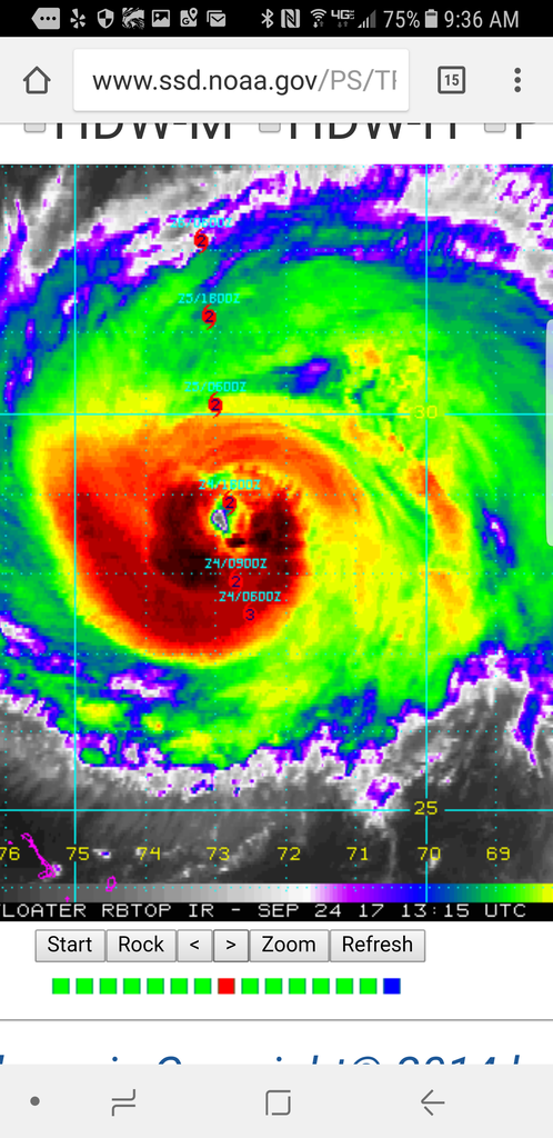
seahawkjd wrote:So from recon positions its moving NNW?

Definitely NNW, which was expected. That east and due north wobble last night was not expected but it has corrected back to it's forecast path and is hitting it's forecast points. Approaching 73 W now. The real interest for the Carolinas is how far past 73w it gets. If it starts closing in on 74w it'll be on the Western side of guidance and Obx and Tidewater will have some trouble.
0 likes   

emeraldislenc
Category 2
Category 2
Posts: 524
Joined: Fri Aug 24, 2012 4:49 pm
Location: Emerald Isle NC

Re: ATL: MARIA - Hurricane - Discussion

#2882 Postby emeraldislenc » Sun Sep 24, 2017 7:36 am

So it is moving nnw now?
0 likes   

WeatherGuesser
Category 5
Category 5
Posts: 2672
Joined: Tue Jun 29, 2010 6:46 am

Re: ATL: MARIA - Hurricane - Discussion

#2883 Postby WeatherGuesser » Sun Sep 24, 2017 7:52 am

emeraldislenc wrote:So it is moving nnw now?


Track is going to be variable as they always are. Don't worry about every little wobble. Coastal NC is in the current 5 Day come of 'maybe somewhere near here' for Wednesday, so you should be making plans accordingly.
1 likes   

User avatar
wxman57
Moderator-Pro Met
Moderator-Pro Met
Posts: 22480
Age: 66
Joined: Sat Jun 21, 2003 8:06 pm
Location: Houston, TX (southwest)

Re: ATL: MARIA - Hurricane - Discussion

#2884 Postby wxman57 » Sun Sep 24, 2017 7:54 am

emeraldislenc wrote:So it is moving nnw now?


Yes, it's moving just as had been predicted. Maria's TS winds may just brush eastern NC before the front arrives and sweeps it off to the NE. Landfall of the center there looks unlikely, but not impossible.
3 likes   

emeraldislenc
Category 2
Category 2
Posts: 524
Joined: Fri Aug 24, 2012 4:49 pm
Location: Emerald Isle NC

Re: ATL: MARIA - Hurricane - Discussion

#2885 Postby emeraldislenc » Sun Sep 24, 2017 7:55 am

Thanks I appreciate your thoughts!
0 likes   

User avatar
GCANE
S2K Supporter
S2K Supporter
Posts: 10787
Joined: Mon Oct 22, 2007 8:03 am

Re: ATL: MARIA - Hurricane - Discussion

#2886 Postby GCANE » Sun Sep 24, 2017 8:01 am

Image
0 likes   

User avatar
'CaneFreak
Category 5
Category 5
Posts: 1475
Joined: Mon Jun 05, 2006 10:50 am
Location: New Bern, NC

Re: ATL: MARIA - Hurricane - Discussion

#2887 Postby 'CaneFreak » Sun Sep 24, 2017 8:02 am

The dreaded southeasterlies have shown up at 300 mb at the 12Z MHX sounding. Eastern NC may have a surprise coming.

Image
0 likes   

seahawkjd
S2K Supporter
S2K Supporter
Posts: 632
Joined: Wed Sep 10, 2003 4:12 pm
Location: Morehead City, NC
Contact:

Re: ATL: MARIA - Hurricane - Discussion

#2888 Postby seahawkjd » Sun Sep 24, 2017 8:05 am

[quote="'CaneFreak"]The dreaded southeasterlies have shown up at 300 mb at the 12Z MHX sounding. Eastern NC may have a surprise coming.


What do you mean?
1 likes   
Gloria, Hugo, Emily, Bertha, Bonnie, Dennis (twice), Fran, Floyd, Isabel, Irene, Arthur, Matthew, Florence, Dorian (and many tropical storms and nor'easters).

emeraldislenc
Category 2
Category 2
Posts: 524
Joined: Fri Aug 24, 2012 4:49 pm
Location: Emerald Isle NC

Re: ATL: MARIA - Hurricane - Discussion

#2889 Postby emeraldislenc » Sun Sep 24, 2017 8:11 am

What do you mean? Please explain.
0 likes   

User avatar
'CaneFreak
Category 5
Category 5
Posts: 1475
Joined: Mon Jun 05, 2006 10:50 am
Location: New Bern, NC

Re: ATL: MARIA - Hurricane - Discussion

#2890 Postby 'CaneFreak » Sun Sep 24, 2017 8:11 am

More ridging than expected. You see most meteorologists don't even look at soundings anymore. They just look at model forecasts and they just accept the output. Not me. I am old school. You can see the ridging very clearly on that sounding. Easterlies at 500 mb, southeasterlies at 300 mb, and southwesterlies at 200 mb. The mid/upper low over the Southeast continues to pull westward with the remnants of Jose now cutting itself off from this PV anomaly over the Southeast. If you look at water vapor imagery, you can see that dry mid level air moving southward down the coast. I see a classic dual outflow setup here with a ridge in between. Going to be an interesting next few days to say the least.

All of this to say that I see a stronger system coming farther west.

seahawkjd wrote:What do you mean?
Last edited by 'CaneFreak on Sun Sep 24, 2017 8:15 am, edited 1 time in total.
3 likes   

Vdogg
Category 2
Category 2
Posts: 619
Joined: Wed Aug 31, 2016 9:56 am

Re: ATL: MARIA - Hurricane - Discussion

#2891 Postby Vdogg » Sun Sep 24, 2017 8:11 am

'CaneFreak wrote:The dreaded southeasterlies have shown up at 300 mb at the 12Z MHX sounding. Eastern NC may have a surprise coming.

Image

What does this mean and how does it affect track?
0 likes   

User avatar
drezee
S2K Supporter
S2K Supporter
Posts: 3643
Joined: Mon Jun 09, 2003 12:49 pm
Location: FL

Re: ATL: MARIA - Hurricane - Discussion

#2892 Postby drezee » Sun Sep 24, 2017 8:22 am

'CaneFreak wrote:The dreaded southeasterlies have shown up at 300 mb at the 12Z MHX sounding. Eastern NC may have a surprise.

I completely agree. Ridging is clear on WV and the Push more NW starts literally right now. She may be at 73W by 17z. If so, then all beats are off for the OBX.
2 likes   

User avatar
Stellar
Tropical Low
Tropical Low
Posts: 11
Joined: Tue Sep 19, 2017 2:38 pm
Location: Virginia Beach, VA

Re: ATL: MARIA - Hurricane - Discussion

#2893 Postby Stellar » Sun Sep 24, 2017 8:24 am

'CaneFreak wrote:More ridging than expected. You see most meteorologists don't even look at soundings anymore. They just look at model forecasts and they just accept the output. Not me. I am old school. You can see the ridging very clearly on that sounding. Easterlies at 500 mb, southeasterlies at 300 mb, and southwesterlies at 200 mb. The mid/upper low over the Southeast continues to pull westward with the remnants of Jose now cutting itself off from this PV anomaly over the Southeast. If you look at water vapor imagery, you can see that dry mid level air moving southward down the coast. I see a classic dual outflow setup here with a ridge in between. Going to be an interesting next few days to say the least.

All of this to say that I see a stronger system coming farther west.

seahawkjd wrote:What do you mean?


Yes, you can see the dry air moving slowly south off the Mid-Atlantic coast: http://col.st/Pu5mF

Would this suggest a landfall slightly west and south of the forecast position?
0 likes   

RL3AO
Moderator-Pro Met
Moderator-Pro Met
Posts: 16308
Joined: Thu Jun 14, 2007 10:03 pm
Location: NC

Re: ATL: MARIA - Hurricane - Discussion

#2894 Postby RL3AO » Sun Sep 24, 2017 8:24 am

'CaneFreak wrote:More ridging than expected. You see most meteorologists don't even look at soundings anymore. They just look at model forecasts and they just accept the output.


Have you met and observed enough operational forecasters to make this assertion? The models are a tool. Soundings are a tool. Satellites are a tool. You can't afford to ignore any of them and solely use one tool.
4 likes   

emeraldislenc
Category 2
Category 2
Posts: 524
Joined: Fri Aug 24, 2012 4:49 pm
Location: Emerald Isle NC

Re: ATL: MARIA - Hurricane - Discussion

#2895 Postby emeraldislenc » Sun Sep 24, 2017 8:26 am

Thanks for your thoughts very interesting
0 likes   

User avatar
drezee
S2K Supporter
S2K Supporter
Posts: 3643
Joined: Mon Jun 09, 2003 12:49 pm
Location: FL

Re: ATL: MARIA - Hurricane - Discussion

#2896 Postby drezee » Sun Sep 24, 2017 8:31 am

29N 73W...if Maria is left of there...i think she hits land. Over or right...i think she misses
1 likes   

Vdogg
Category 2
Category 2
Posts: 619
Joined: Wed Aug 31, 2016 9:56 am

Re: ATL: MARIA - Hurricane - Discussion

#2897 Postby Vdogg » Sun Sep 24, 2017 8:33 am

Storm seems slightly faster than the models/forecast points show. Ragged eyewall touching 73w now. May just be a wobble but it looks like it'll come in slightly west of it's next forecast point.
0 likes   

Vdogg
Category 2
Category 2
Posts: 619
Joined: Wed Aug 31, 2016 9:56 am

Re: ATL: MARIA - Hurricane - Discussion

#2898 Postby Vdogg » Sun Sep 24, 2017 8:43 am

Image
Getting ready to cross now. Wasn't supposed to happen till 16z. I'd be shocked if models don't trend west this afternoon.
1 likes   

User avatar
'CaneFreak
Category 5
Category 5
Posts: 1475
Joined: Mon Jun 05, 2006 10:50 am
Location: New Bern, NC

Re: ATL: MARIA - Hurricane - Discussion

#2899 Postby 'CaneFreak » Sun Sep 24, 2017 8:43 am

We'll see what happens. All I am doing here is posting observations. It may go offshore or it may come close to the coast. No one can say with any level of certainty. All I am saying is that from the chair I am sitting in, it looks like this is going to head farther west than currently forecast.

RL3AO wrote:
'CaneFreak wrote:More ridging than expected. You see most meteorologists don't even look at soundings anymore. They just look at model forecasts and they just accept the output.


Have you met and observed enough operational forecasters to make this assertion? The models are a tool. Soundings are a tool. Satellites are a tool. You can't afford to ignore any of them and solely use one tool.
1 likes   

User avatar
pgoss11
Category 2
Category 2
Posts: 702
Joined: Tue Sep 02, 2003 3:55 pm

Re: ATL: MARIA - Hurricane - Discussion

#2900 Postby pgoss11 » Sun Sep 24, 2017 8:43 am

Vdogg wrote:Storm seems slightly faster than the models/forecast points show. Ragged eyewall touching 73w now. May just be a wobble but it looks like it'll come in slightly west of it's next forecast point.


I noticed this too. Almost looks like Maria has turned more NW than NNW. Will have to watch to see if it's real or just a wobble.
2 likes   


Return to “2017”

Who is online

Users browsing this forum: No registered users and 113 guests