
WPAC: TEMBIN - Post-Tropical
Moderator: S2k Moderators
-
1900hurricane

- Category 5

- Posts: 6044
- Age: 32
- Joined: Fri Feb 06, 2015 12:04 pm
- Location: Houston, TX
- Contact:
Re: WPAC: Tropical Depression 97W
Even without ASCAT data (which should come in soon), I'd seriously consider classifying at 12Z. Going to be hard not to based on apparent banding.
0 likes
Contract Meteorologist. TAMU & MSST. Fiercely authentic, one of a kind. We are all given free will, so choose a life meant to be lived. We are the Masters of our own Stories.
Opinions expressed are mine alone.
Follow me on Twitter at @1900hurricane : Read blogs at https://1900hurricane.wordpress.com/
Opinions expressed are mine alone.
Follow me on Twitter at @1900hurricane : Read blogs at https://1900hurricane.wordpress.com/
-
doomhaMwx

- Category 5
- Posts: 2398
- Age: 25
- Joined: Tue Apr 18, 2017 4:01 am
- Location: Baguio/Benguet, Philippines
- Contact:
Re: WPAC: Tropical Depression 97W
Next name's "Tembin".

0 likes
Like my content? Consider giving a tip.
-
mrbagyo

- Category 5
- Posts: 3614
- Age: 31
- Joined: Thu Apr 12, 2012 9:18 am
- Location: 14.13N 120.98E
- Contact:
Re: WPAC: Tropical Depression 97W
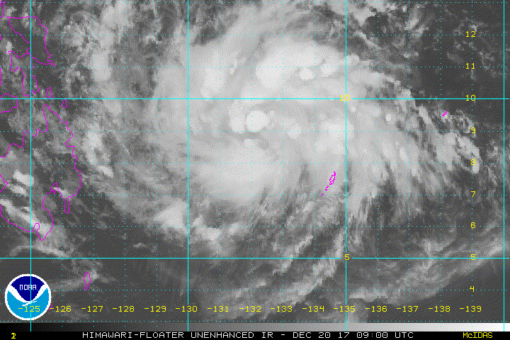
looks classifiable
0 likes
The posts in this forum are NOT official forecast and should not be used as such. They are just the opinion of the poster and may or may not be backed by sound meteorological data. They are NOT endorsed by any professional institution or storm2k.org. For official information, please refer to RSMC, NHC and NWS products.

-
cycloneye

- Admin

- Posts: 139049
- Age: 67
- Joined: Thu Oct 10, 2002 10:54 am
- Location: San Juan, Puerto Rico
Re: WPAC: Tropical Depression 33W
JTWC will upgrade at 21:00 UTC to TD.
33W THIRTYTHRE
As of 18:00 UTC Dec 20, 2017:
Location: 8.3°N 131.0°E
Maximum Winds: 25 kt
Minimum Central Pressure: 1006 mb

33W THIRTYTHRE
As of 18:00 UTC Dec 20, 2017:
Location: 8.3°N 131.0°E
Maximum Winds: 25 kt
Minimum Central Pressure: 1006 mb
0 likes
Visit the Caribbean-Central America Weather Thread where you can find at first post web cams,radars
and observations from Caribbean basin members Click Here
and observations from Caribbean basin members Click Here
-
cycloneye
- Admin
- Posts: 139049
- Age: 67
- Joined: Thu Oct 10, 2002 10:54 am
- Location: San Juan, Puerto Rico
Re: WPAC: TEMBIN - Tropical Storm
JMA upgrades to Tropical Storm TEMBIN
TS 1727 (Tembin)
Issued at 19:05 UTC, 20 December 2017
<Analysis at 18 UTC, 20 December>
Scale -
Intensity -
Center position N9°00' (9.0°)
E130°40' (130.7°)
Direction and speed of movement W 20 km/h (10 kt)
Central pressure 1000 hPa
Maximum wind speed near center 18 m/s (35 kt)
Maximum wind gust speed 25 m/s (50 kt)
≥ 30 kt wind area ALL 170 km (90 NM)
<Forecast for 06 UTC, 21 December>
Intensity -
Center position of probability circle N9°00' (9.0°)
E129°00' (129.0°)
Direction and speed of movement W 15 km/h (8 kt)
Central pressure 1000 hPa
Maximum wind speed near center 18 m/s (35 kt)
Maximum wind gust speed 25 m/s (50 kt)
Radius of probability circle 60 km (30 NM)
<Forecast for 18 UTC, 21 December>
Intensity -
Center position of probability circle N9°00' (9.0°)
E127°25' (127.4°)
Direction and speed of movement W 15 km/h (8 kt)
Central pressure 998 hPa
Maximum wind speed near center 20 m/s (40 kt)
Maximum wind gust speed 30 m/s (60 kt)
Radius of probability circle 90 km (50 NM)
<Forecast for 18 UTC, 22 December>
Intensity -
Center position of probability circle N8°55' (8.9°)
E122°55' (122.9°)
Direction and speed of movement W 20 km/h (11 kt)
Central pressure 998 hPa
Maximum wind speed near center 20 m/s (40 kt)
Maximum wind gust speed 30 m/s (60 kt)
Radius of probability circle 200 km (110 NM)
<Forecast for 18 UTC, 23 December>
Intensity -
Center position of probability circle N8°20' (8.3°)
E119°40' (119.7°)
Direction and speed of movement W 15 km/h (8 kt)
Central pressure 994 hPa
Maximum wind speed near center 23 m/s (45 kt)
Maximum wind gust speed 35 m/s (65 kt)
Radius of probability circle 240 km (130 NM)
0 likes
Visit the Caribbean-Central America Weather Thread where you can find at first post web cams,radars
and observations from Caribbean basin members Click Here
and observations from Caribbean basin members Click Here
-
cycloneye
- Admin
- Posts: 139049
- Age: 67
- Joined: Thu Oct 10, 2002 10:54 am
- Location: San Juan, Puerto Rico
Re: WPAC: TEMBIN - Tropical Storm
JTWC first warning.They forecast a 65 kt Typhoon at SCS.

0 likes
Visit the Caribbean-Central America Weather Thread where you can find at first post web cams,radars
and observations from Caribbean basin members Click Here
and observations from Caribbean basin members Click Here

Re: WPAC: TEMBIN - Tropical Storm
Finally 33W Tembin is here.
WDPN32 PGTW 202100
MSGID/GENADMIN/JOINT TYPHOON WRNCEN PEARL HARBOR HI//
SUBJ/PROGNOSTIC REASONING FOR TROPICAL DEPRESSION 33W (THIRTY-THREE)
WARNING NR 01//
RMKS//
1. FOR METEOROLOGISTS.
2. 6 HOUR SUMMARY AND ANALYSIS.
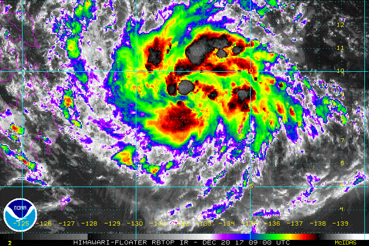
TROPICAL DEPRESSION (TD) 33W (THIRTY-THREE), LOCATED APPROXIMATELY
211 NM WEST-NORTHWEST OF KOROR, PALAU, HAS TRACKED WEST-NORTHWESTWARD
AT 12 KNOTS OVER THE PAST SIX HOURS. ANIMATED ENHANCED INFRARED (EIR)
SATELLITE IMAGERY SHOWS A RAPIDLY CONSOLIDATING SYSTEM WITH FORMATIVE
BANDS WRAPPING INTO AND DEEPENING CENTRAL CONVECTION OBSCURING THE
LOW LEVEL CIRCULATION. THE INITIAL POSITION IS BASED ON THE EIR LOOP
WITH LOW CONFIDENCE. THE INITIAL INTENSITY OF 25 KNOTS IS BASED ON AN
OVERALL ASSESSMENT OF MULTI-AGENCY DVORAK ESTIMATES. UPPER-LEVEL
ANALYSIS INDICATES A FAVORABLE ENVIRONMENT CHARACTERIZED BY STRONG
POLEWARD OUTFLOW AND LOW TO MODERATE (10-15 KNOT) VERTICAL WIND
SHEAR (VWS). ADDITIONALLY, SEA SURFACE TEMPERATURES IN THE PHILIPPINE
SEA AT 29 CELSIUS ARE CONDUCIVE FOR DEVELOPMENT. THE CYCLONE IS
CURRENTLY TRACKING ALONG THE SOUTHERN PERIPHERY OF THE SUBTROPICAL
RIDGE (STR)
TO THE NORTHEAST.
3. FORECAST REASONING.
A. THIS IS THE INITIAL PROGNOSTIC REASONING MESSAGE. AND SETS THE
FORECAST PHILOSOPHY ON THIS SYSTEM.
B. TD 33W IS FORECAST TO TRACK ON A MORE WESTWARD TRAJECTORY AS
THE STR TO THE NORTHWEST ASSUMES STEERING FROM THE CURRENT STR. THE
SYSTEM WILL MAKE LANDFALL OVER NORTHEASTERN MINDANAO AFTER TAU 24 AND
CROSS THE SOUTHERN PHILIPPINE ARCHIPELAGO. BY TAU 72, TD 33W WILL
MAKE LANDFALL OVER PALAWAN JUST SOUTH OF PUERTO PRINCESA. THE
AFOREMENTIONED FAVORABLE CONDITIONS ARE EXPECTED TO PERSIST, LIMITED
ONLY BY FRICTIONAL EFFECTS FROM THE ISLANDS. BY TAU 72, THE SYSTEM
WILL REACH 60 KNOTS.
C. AFTER TAU 72, TD 33W WILL RESUME A WEST-NORTHWESTWARD TRACK AS
THE STEERING STR WEAKENS. THE SYSTEM WILL EXIT INTO THE SOUTH CHINA
SEA AND FURTHER INTENSIFY AS FAVORABLE CONDITIONS PERSIST, PEAKING AT
A TYPHOON INTENSITY OF 65 KNOTS BY TAU 96. AFTERWARD, VWS IS EXPECTED
TO INCREASE, GRADUALLY WEAKENING THE SYSTEM TO 45 KNOTS RIGHT BEFORE
LANDFALL INTO SOUTHERN VIETNAM BY TAU 120. THE INITIAL SET OF NUMERIC
MODEL GUIDANCE IS IN GOOD AGREEMENT WITH SOME SPREADING AT THE
EXTENDED TAUS. NAVGEM IS A NOTABLE NORTHERN OUTLIER. GIVEN THESE AND
THE FORMATIVE STAGE OF THE SYSTEM, THERE IS LOW CONFIDENCE IN THE
INITIAL JTWC TRACK FORECAST.//
NNNN
WDPN32 PGTW 202100
MSGID/GENADMIN/JOINT TYPHOON WRNCEN PEARL HARBOR HI//
SUBJ/PROGNOSTIC REASONING FOR TROPICAL DEPRESSION 33W (THIRTY-THREE)
WARNING NR 01//
RMKS//
1. FOR METEOROLOGISTS.
2. 6 HOUR SUMMARY AND ANALYSIS.
TROPICAL DEPRESSION (TD) 33W (THIRTY-THREE), LOCATED APPROXIMATELY
211 NM WEST-NORTHWEST OF KOROR, PALAU, HAS TRACKED WEST-NORTHWESTWARD
AT 12 KNOTS OVER THE PAST SIX HOURS. ANIMATED ENHANCED INFRARED (EIR)
SATELLITE IMAGERY SHOWS A RAPIDLY CONSOLIDATING SYSTEM WITH FORMATIVE
BANDS WRAPPING INTO AND DEEPENING CENTRAL CONVECTION OBSCURING THE
LOW LEVEL CIRCULATION. THE INITIAL POSITION IS BASED ON THE EIR LOOP
WITH LOW CONFIDENCE. THE INITIAL INTENSITY OF 25 KNOTS IS BASED ON AN
OVERALL ASSESSMENT OF MULTI-AGENCY DVORAK ESTIMATES. UPPER-LEVEL
ANALYSIS INDICATES A FAVORABLE ENVIRONMENT CHARACTERIZED BY STRONG
POLEWARD OUTFLOW AND LOW TO MODERATE (10-15 KNOT) VERTICAL WIND
SHEAR (VWS). ADDITIONALLY, SEA SURFACE TEMPERATURES IN THE PHILIPPINE
SEA AT 29 CELSIUS ARE CONDUCIVE FOR DEVELOPMENT. THE CYCLONE IS
CURRENTLY TRACKING ALONG THE SOUTHERN PERIPHERY OF THE SUBTROPICAL
RIDGE (STR)
TO THE NORTHEAST.
3. FORECAST REASONING.
A. THIS IS THE INITIAL PROGNOSTIC REASONING MESSAGE. AND SETS THE
FORECAST PHILOSOPHY ON THIS SYSTEM.
B. TD 33W IS FORECAST TO TRACK ON A MORE WESTWARD TRAJECTORY AS
THE STR TO THE NORTHWEST ASSUMES STEERING FROM THE CURRENT STR. THE
SYSTEM WILL MAKE LANDFALL OVER NORTHEASTERN MINDANAO AFTER TAU 24 AND
CROSS THE SOUTHERN PHILIPPINE ARCHIPELAGO. BY TAU 72, TD 33W WILL
MAKE LANDFALL OVER PALAWAN JUST SOUTH OF PUERTO PRINCESA. THE
AFOREMENTIONED FAVORABLE CONDITIONS ARE EXPECTED TO PERSIST, LIMITED
ONLY BY FRICTIONAL EFFECTS FROM THE ISLANDS. BY TAU 72, THE SYSTEM
WILL REACH 60 KNOTS.
C. AFTER TAU 72, TD 33W WILL RESUME A WEST-NORTHWESTWARD TRACK AS
THE STEERING STR WEAKENS. THE SYSTEM WILL EXIT INTO THE SOUTH CHINA
SEA AND FURTHER INTENSIFY AS FAVORABLE CONDITIONS PERSIST, PEAKING AT
A TYPHOON INTENSITY OF 65 KNOTS BY TAU 96. AFTERWARD, VWS IS EXPECTED
TO INCREASE, GRADUALLY WEAKENING THE SYSTEM TO 45 KNOTS RIGHT BEFORE
LANDFALL INTO SOUTHERN VIETNAM BY TAU 120. THE INITIAL SET OF NUMERIC
MODEL GUIDANCE IS IN GOOD AGREEMENT WITH SOME SPREADING AT THE
EXTENDED TAUS. NAVGEM IS A NOTABLE NORTHERN OUTLIER. GIVEN THESE AND
THE FORMATIVE STAGE OF THE SYSTEM, THERE IS LOW CONFIDENCE IN THE
INITIAL JTWC TRACK FORECAST.//
NNNN
0 likes
Remember, all of my post aren't official. For official warnings and discussions, Please refer to your local NWS products...
NWS for the Western Pacific
https://www.weather.gov/gum/
NWS for the Western Pacific
https://www.weather.gov/gum/
Re: WPAC: TEMBIN - Tropical Storm
the JT advisory is incredibly inaccurate. This is much stronger than a 25 kt depression
1 likes
Re: WPAC: TEMBIN - Tropical Storm
Both GFS and EURO sees some significant strengthening in the SCS.
0 likes
Remember, all of my post aren't official. For official warnings and discussions, Please refer to your local NWS products...
NWS for the Western Pacific
https://www.weather.gov/gum/
NWS for the Western Pacific
https://www.weather.gov/gum/
-
Digital-TC-Chaser
Re: WPAC: TEMBIN - Tropical Storm


Be watching this for some RI very good ohc & upper exhaust vent on the plot.
0 likes
Re: WPAC: TEMBIN - Tropical Storm
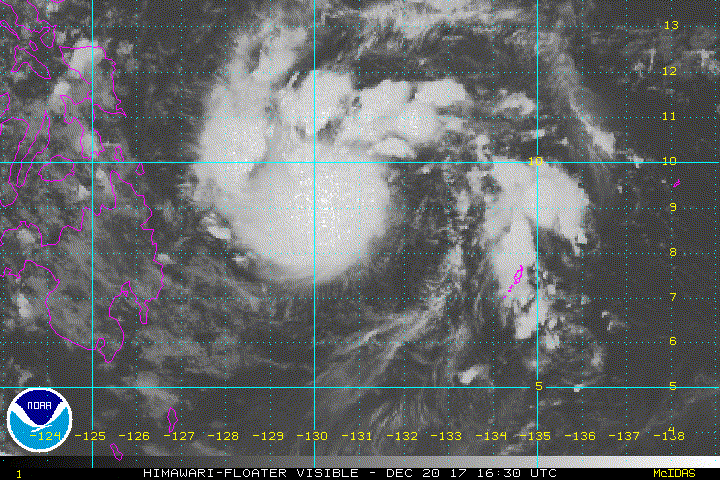
not going to be any RI. The center is east of the convection. Likely a 40-45 kt TS over Mindanao. However, that is similar to Washi
0 likes
-
mrbagyo
- Category 5
- Posts: 3614
- Age: 31
- Joined: Thu Apr 12, 2012 9:18 am
- Location: 14.13N 120.98E
- Contact:
Re: WPAC: TEMBIN - Tropical Storm
Alyono wrote:not going to be any RI. The center is east of the convection. Likely a 40-45 kt TS over Mindanao. However, that is similar to Washi
I agree, circulation is partially exposed at the moment. Likely wont have enough time to do RI before Mindanao.
0 likes
The posts in this forum are NOT official forecast and should not be used as such. They are just the opinion of the poster and may or may not be backed by sound meteorological data. They are NOT endorsed by any professional institution or storm2k.org. For official information, please refer to RSMC, NHC and NWS products.
-
Digital-TC-Chaser
Re: WPAC: TEMBIN - Tropical Storm
Alyono wrote:not going to be any RI. The center is east of the convection. Likely a 40-45 kt TS over Mindanao. However, that is similar to Washi
No RI not even a brief one is good news. Take your Pro opinion with respect always.
0 likes
Re: WPAC: TEMBIN - Tropical Storm
Now up to TS.
33W TEMBIN 171221 0000 8.6N 129.5E WPAC 35 1003
33W TEMBIN 171221 0000 8.6N 129.5E WPAC 35 1003
0 likes
Remember, all of my post aren't official. For official warnings and discussions, Please refer to your local NWS products...
NWS for the Western Pacific
https://www.weather.gov/gum/
NWS for the Western Pacific
https://www.weather.gov/gum/
Re: WPAC: TEMBIN - Tropical Storm
UW - CIMSS
ADVANCED DVORAK TECHNIQUE
ADT-Version 8.2.1
Tropical Cyclone Intensity Algorithm
----- Current Analysis -----
Date : 21 DEC 2017 Time : 004000 UTC
Lat : 8:31:57 N Lon : 129:57:08 E
CI# /Pressure/ Vmax
2.3 /1008.7mb/ 33.0kt
Final T# Adj T# Raw T#
2.3 2.4 2.4
Center Temp : -35.3C Cloud Region Temp : -45.0C
Scene Type : CURVED BAND with 0.50 ARC in LT GRAY
Maximum CURVED BAND with 0.56 ARC in LT GRAY
at Lat: 9:07:48 N Lon: 129:56:59 E
Positioning Method : FORECAST INTERPOLATION
Ocean Basin : WEST PACIFIC
Dvorak CI > MSLP Conversion Used : CKZ Method
Tno/CI Rules : Constraint Limits : NO LIMIT
Weakening Flag : OFF
Rapid Dissipation Flag : OFF
C/K/Z MSLP Estimate Inputs :
- Average 34 knot radii : 92km
- Environmental MSLP : 1010mb
Satellite Name : HIM-8
Satellite Viewing Angle : 16.3 degrees
****************************************************
0 likes
Remember, all of my post aren't official. For official warnings and discussions, Please refer to your local NWS products...
NWS for the Western Pacific
https://www.weather.gov/gum/
NWS for the Western Pacific
https://www.weather.gov/gum/
-
doomhaMwx
- Category 5
- Posts: 2398
- Age: 25
- Joined: Tue Apr 18, 2017 4:01 am
- Location: Baguio/Benguet, Philippines
- Contact:
Re: WPAC: TEMBIN - Tropical Storm
Appears to be feeling some easterly shear.


0 likes
Like my content? Consider giving a tip.

-
doomhaMwx
- Category 5
- Posts: 2398
- Age: 25
- Joined: Tue Apr 18, 2017 4:01 am
- Location: Baguio/Benguet, Philippines
- Contact:
Re: WPAC: TEMBIN - Tropical Storm
Model guidance indicates that the system could dump rainfall totals reaching/exceeding 100-200mm(4-8in) to the northern half of Mindanao, and parts of Visayas during its passage.

0 likes
Like my content? Consider giving a tip.
-
cycloneye
- Admin
- Posts: 139049
- Age: 67
- Joined: Thu Oct 10, 2002 10:54 am
- Location: San Juan, Puerto Rico
Re: WPAC: TEMBIN - Tropical Storm
JTWC upgrades to TS at 35 kts.

0 likes
Visit the Caribbean-Central America Weather Thread where you can find at first post web cams,radars
and observations from Caribbean basin members Click Here
and observations from Caribbean basin members Click Here
Who is online
Users browsing this forum: No registered users and 31 guests