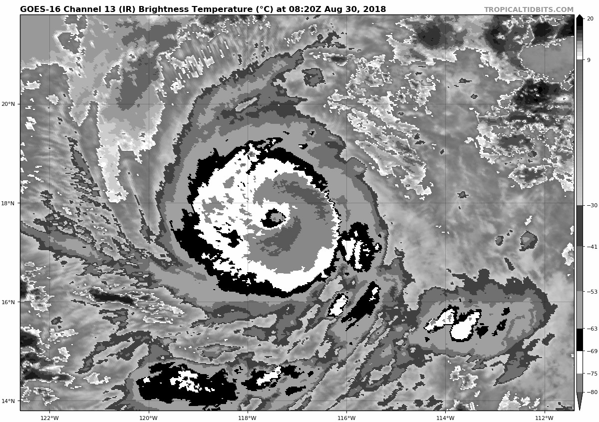
30/0600 UTC 17.8N 117.0W T5.5/5.5 NORMAN -- East Pacific
CPAC: NORMAN - Post-Tropical
Moderator: S2k Moderators
-
Yellow Evan

- Professional-Met

- Posts: 15959
- Age: 25
- Joined: Fri Jul 15, 2011 12:48 pm
- Location: Henderson, Nevada/Honolulu, HI
- Contact:
-
Yellow Evan
- Professional-Met
- Posts: 15959
- Age: 25
- Joined: Fri Jul 15, 2011 12:48 pm
- Location: Henderson, Nevada/Honolulu, HI
- Contact:
Re: EPAC: NORMAN - Hurricane
TXPZ26 KNES 300625
TCSENP
A. 16E (NORMAN)
B. 30/0600Z
C. 17.8N
D. 117.0W
E. ONE/GOES-W
F. T5.5/5.5/D2.0/24HRS
G. IR/EIR/SWIR
H. REMARKS...OW EYE SURROUNDED AND EMBEDDED BY B RESULTS IN DT=6.0 AFTER
+0.5 EYE ADJUSTMENT. MET=5.0 AND PT=5.5. FT IS BASED ON THE CONSTRAINT
1.0/6 HRS.
I. ADDL POSITIONS
NIL
...BOLL
TCSENP
A. 16E (NORMAN)
B. 30/0600Z
C. 17.8N
D. 117.0W
E. ONE/GOES-W
F. T5.5/5.5/D2.0/24HRS
G. IR/EIR/SWIR
H. REMARKS...OW EYE SURROUNDED AND EMBEDDED BY B RESULTS IN DT=6.0 AFTER
+0.5 EYE ADJUSTMENT. MET=5.0 AND PT=5.5. FT IS BASED ON THE CONSTRAINT
1.0/6 HRS.
I. ADDL POSITIONS
NIL
...BOLL
0 likes
-
Yellow Evan
- Professional-Met
- Posts: 15959
- Age: 25
- Joined: Fri Jul 15, 2011 12:48 pm
- Location: Henderson, Nevada/Honolulu, HI
- Contact:
Re: EPAC: NORMAN - Hurricane
EP, 16, 201808300600, 10, DVTS, CI, , 1780N, 11700W, , 1, 90, 2, 970, 2, DVRK, , , , , , , , , , , , , , E, TAFB, DM, I, 1, 5050 /////, , , GOES15, CSC, T,
0 likes
-
storminabox
- Category 1

- Posts: 260
- Joined: Sun Jul 09, 2017 10:50 pm
Re: EPAC: NORMAN - Hurricane
Norman is slowing evolving into a great looking hurricane. Can’t the same about Miriam though...
0 likes
-
Kingarabian

- S2K Supporter

- Posts: 15456
- Joined: Sat Aug 08, 2009 3:06 am
- Location: Honolulu, Hawaii
Re: EPAC: NORMAN - Hurricane
COAMPS makes this a beastly Cat.5. Would be nuts to see 3 cat.5's already with still the September and October peaks to come.
2 likes
RIP Kobe Bryant
-
Kingarabian
- S2K Supporter
- Posts: 15456
- Joined: Sat Aug 08, 2009 3:06 am
- Location: Honolulu, Hawaii
Re: EPAC: NORMAN - Hurricane
Track for Norman still far from being set in stone. GFS and FV3 in their past couple of runs have been shifting the track back a bit closer to Hawaii (closer to Ignacio 2015, Lester 2016), but still north of the islands. Euro now has a full on recurve as soon as it enters the CPAC. UKMET continues to have the most southern track between the GFS and Euro through 144 hours.
0 likes
RIP Kobe Bryant
-
1900hurricane

- Category 5

- Posts: 6044
- Age: 33
- Joined: Fri Feb 06, 2015 12:04 pm
- Location: Houston, TX
- Contact:
Re: EPAC: NORMAN - Hurricane
The cloud tops are a good bit colder than they've been for some of the other recent systems, meaning a higher potential intensity ceiling. We'll see how much of that is realized over the next few days, but Norman is looking pretty good right now.

3 likes
Contract Meteorologist. TAMU & MSST. Fiercely authentic, one of a kind. We are all given free will, so choose a life meant to be lived. We are the Masters of our own Stories.
Opinions expressed are mine alone.
Follow me on Twitter at @1900hurricane : Read blogs at https://1900hurricane.wordpress.com/
Opinions expressed are mine alone.
Follow me on Twitter at @1900hurricane : Read blogs at https://1900hurricane.wordpress.com/
-
cycloneye

- Admin

- Posts: 139519
- Age: 67
- Joined: Thu Oct 10, 2002 10:54 am
- Location: San Juan, Puerto Rico
Re: EPAC: NORMAN - Hurricane
Hurricane Norman Discussion Number 8
NWS National Hurricane Center Miami FL EP162018
200 AM PDT Thu Aug 30 2018
Norman is in the midst of a remarkable period of rapid
intensification. An eye developed in infrared satellite imagery
around 0500 UTC and is completely surrounded by very cold cloud
tops quadrants. A burst of lightning also began a couple of hours
ago in the southeastern quadrant, where cloud tops are as cold as
-84C. Subjective Dvorak estimates rose quickly to T5.5/102 kt from
SAB and T5.0/90 kt from TAFB at 0600 UTC, and since the satellite
presentation has continued to improve, the initial intensity is set
near the top of that range at 100 kt, making Norman a major
hurricane. Norman's intensity has increased by an estimated 45-50
kt over the past 24 hours.
Norman remains in a low-shear environment with good upper-level
outflow in all quadrants, and the hurricane is moving over very
warm waters of 29-30 degrees Celsius. Barring any unforeseen
structural changes like an eyewall replacement, Norman is likely to
continue strengthening for the next 24 hours or so, and nearly all
of the intensity models depict the current rapid intensification
phase persisting for the next 12 hours. The updated NHC intensity
forecast has been increased during the first 48 hours to account
for recent trends, and it closely matches an average of the HCCA
model, Florida State Superensemble, and ICON intensity consensus.
A very gradual weakening is expected after 48 hours as Norman
encounters some shear and cooler waters.
A strong subtropical ridge extending west of northern Mexico is
steering Norman westward, or 275/6 kt. The depth and strength of
the ridge is expected to force Norman west-southwestward during the
next 24-48 hours, followed by a turn back toward the west and then
west-northwest on days 3-5. The track models are in fairly good
agreement throughout the 5-day forecast period, although there are
some differences in exactly how much of an S-curve Norman will
make. The ECMWF shows the most pronounced bend in the forecast
track, starting along the southern periphery of the guidance
envelope and then moving to the northern periphery by days 4 and 5.
Although the new NHC track forecast does not follow the ECMWF
exactly, it does show slightly more bend than the previous forecast.
FORECAST POSITIONS AND MAX WINDS
INIT 30/0900Z 17.8N 117.4W 100 KT 115 MPH
12H 30/1800Z 17.9N 118.5W 115 KT 130 MPH
24H 31/0600Z 17.6N 120.1W 120 KT 140 MPH
36H 31/1800Z 17.0N 121.6W 120 KT 140 MPH
48H 01/0600Z 16.3N 123.3W 115 KT 130 MPH
72H 02/0600Z 16.2N 127.1W 105 KT 120 MPH
96H 03/0600Z 18.0N 132.0W 95 KT 110 MPH
120H 04/0600Z 20.0N 137.5W 75 KT 85 MPH
$$
Forecaster Berg
0 likes
Visit the Caribbean-Central America Weather Thread where you can find at first post web cams,radars
and observations from Caribbean basin members Click Here
and observations from Caribbean basin members Click Here
-
cycloneye
- Admin
- Posts: 139519
- Age: 67
- Joined: Thu Oct 10, 2002 10:54 am
- Location: San Juan, Puerto Rico
Re: EPAC: NORMAN - Hurricane
@EricBlake12
Boy that escalated quickly- #Norman is already a major hurricane and is on the way to becoming another powerful category 4 #hurricane. Thankfully no immediate threat to land
https://twitter.com/EricBlake12/status/1035112479632830464
Boy that escalated quickly- #Norman is already a major hurricane and is on the way to becoming another powerful category 4 #hurricane. Thankfully no immediate threat to land
https://twitter.com/EricBlake12/status/1035112479632830464
2 likes
Visit the Caribbean-Central America Weather Thread where you can find at first post web cams,radars
and observations from Caribbean basin members Click Here
and observations from Caribbean basin members Click Here

Re: EPAC: NORMAN - Hurricane
Maybe run at Cat 5? Needs WMG
NHC forecast is another 15-16 units on top of 2-3 units already. I'm going to guess he ends up with 30+ units of ACE.
UW - CIMSS
ADVANCED DVORAK TECHNIQUE
ADT-Version 9.0
Tropical Cyclone Intensity Algorithm
----- Current Analysis -----
Date : 30 AUG 2018 Time : 103000 UTC
Lat : 17:48:55 N Lon : 117:35:17 W
CI# /Pressure/ Vmax
5.7 / 954.0mb/107.2kt
Final T# Adj T# Raw T#
5.7 5.8 7.3
Estimated radius of max. wind based on IR :N/A km
Center Temp : -38.8C Cloud Region Temp : -77.9C
Scene Type : EYE
NHC forecast is another 15-16 units on top of 2-3 units already. I'm going to guess he ends up with 30+ units of ACE.
1 likes
The above post and any post by Ntxw is NOT an official forecast and should not be used as such. It is just the opinion of the poster and may or may not be backed by sound meteorological data. It is NOT endorsed by any professional institution including Storm2k. For official information, please refer to NWS products.
Help support Storm2K!

-
Yellow Evan
- Professional-Met
- Posts: 15959
- Age: 25
- Joined: Fri Jul 15, 2011 12:48 pm
- Location: Henderson, Nevada/Honolulu, HI
- Contact:

-
xtyphooncyclonex

- Category 5
- Posts: 3688
- Age: 22
- Joined: Sat Dec 08, 2012 9:07 am
- Location: Cebu City
- Contact:
Re: EPAC: NORMAN - Hurricane
Jebi vs Norman... I wonder which would reach category 5 first.
0 likes
REMINDER: My opinions that I, or any other NON Pro-Met in this forum, are unofficial. Please do not take my opinions as an official forecast and warning. I am NOT a meteorologist. Following my forecasts blindly may lead to false alarm, danger and risk if official forecasts from agencies are ignored.
-
Yellow Evan
- Professional-Met
- Posts: 15959
- Age: 25
- Joined: Fri Jul 15, 2011 12:48 pm
- Location: Henderson, Nevada/Honolulu, HI
- Contact:
Re: EPAC: NORMAN - Hurricane
TXPZ26 KNES 301219
TCSENP
A. 16E (NORMAN)
B. 30/1200Z
C. 17.8N
D. 117.6W
E. ONE/GOES-W
F. T6.0/6.0/D2.5/24HRS
G. IR/EIR
H. REMARKS...OW EYE SURROUNDED BY W AND EMBEDDED IN W YIELDS E#6.0
AND +0.5 EYE ADJUSTMENT. 6-HR AVERAGING YIELDS A DT OF 6.0. MET=5.5
PT=6.0. FT IS BASED ON DT.
I. ADDL POSITIONS
NIL
...VELASCO
TCSENP
A. 16E (NORMAN)
B. 30/1200Z
C. 17.8N
D. 117.6W
E. ONE/GOES-W
F. T6.0/6.0/D2.5/24HRS
G. IR/EIR
H. REMARKS...OW EYE SURROUNDED BY W AND EMBEDDED IN W YIELDS E#6.0
AND +0.5 EYE ADJUSTMENT. 6-HR AVERAGING YIELDS A DT OF 6.0. MET=5.5
PT=6.0. FT IS BASED ON DT.
I. ADDL POSITIONS
NIL
...VELASCO
0 likes
-
xtyphooncyclonex
- Category 5
- Posts: 3688
- Age: 22
- Joined: Sat Dec 08, 2012 9:07 am
- Location: Cebu City
- Contact:
Re: EPAC: NORMAN - Hurricane
326
WTPZ41 KNHC 301232
TCDEP1
Hurricane Norman Special Discussion Number 9
NWS National Hurricane Center Miami FL EP162018
530 AM PDT Thu Aug 30 2018
Satellite data show that Norman continues to rapidly strengthen.
Objective Dvorak data T-numbers from UW/CIMSS have increased to T6.5
or higher and the latest TAFB subjective data T-number is T6.5.
These estimates support an initial intensity of 125 kt, making
Norman a category 4 hurricane on the Saffir-Simpson Hurricane Wind
Scale. As a result of the increased initial intensity, the NHC
intensity forecast has been adjusted upward through 36 h, but it is
otherwise unchanged. There has been no change to the NHC track
forecast.
FORECAST POSITIONS AND MAX WINDS
INIT 30/1230Z 17.8N 117.7W 125 KT 145 MPH
12H 30/1800Z 17.9N 118.5W 135 KT 155 MPH
24H 31/0600Z 17.6N 120.1W 135 KT 155 MPH
36H 31/1800Z 17.0N 121.6W 125 KT 145 MPH
48H 01/0600Z 16.3N 123.3W 115 KT 130 MPH
72H 02/0600Z 16.2N 127.1W 105 KT 120 MPH
96H 03/0600Z 18.0N 132.0W 95 KT 110 MPH
120H 04/0600Z 20.0N 137.5W 75 KT 85 MPH
$$
Forecaster Brown
0 likes
REMINDER: My opinions that I, or any other NON Pro-Met in this forum, are unofficial. Please do not take my opinions as an official forecast and warning. I am NOT a meteorologist. Following my forecasts blindly may lead to false alarm, danger and risk if official forecasts from agencies are ignored.
-
Yellow Evan
- Professional-Met
- Posts: 15959
- Age: 25
- Joined: Fri Jul 15, 2011 12:48 pm
- Location: Henderson, Nevada/Honolulu, HI
- Contact:
Re: EPAC: NORMAN - Hurricane
Raw ADT already through the roof.
----- Current Analysis -----
Date : 30 AUG 2018 Time : 113000 UTC
Lat : 17:46:48 N Lon : 117:26:59 W
CI# /Pressure/ Vmax
5.7 / 954.0mb/107.2kt
Final T# Adj T# Raw T#
5.7 5.8 7.4
Estimated radius of max. wind based on IR :N/A km
Center Temp : -27.6C Cloud Region Temp : -77.8C
Scene Type : EYE
Date : 30 AUG 2018 Time : 113000 UTC
Lat : 17:46:48 N Lon : 117:26:59 W
CI# /Pressure/ Vmax
5.7 / 954.0mb/107.2kt
Final T# Adj T# Raw T#
5.7 5.8 7.4
Estimated radius of max. wind based on IR :N/A km
Center Temp : -27.6C Cloud Region Temp : -77.8C
Scene Type : EYE
1 likes
Re: EPAC: NORMAN - Hurricane
Been a while since I’ve seen one intensify this fast, jumped 60 mph in about 9 hours 
1 likes
-
cycloneye
- Admin
- Posts: 139519
- Age: 67
- Joined: Thu Oct 10, 2002 10:54 am
- Location: San Juan, Puerto Rico
Re: EPAC: NORMAN - Hurricane
Hurricane Norman Special Discussion Number 9
NWS National Hurricane Center Miami FL EP162018
530 AM PDT Thu Aug 30 2018
Satellite data show that Norman continues to rapidly strengthen.
Objective Dvorak data T-numbers from UW/CIMSS have increased to T6.5
or higher and the latest TAFB subjective data T-number is T6.5.
These estimates support an initial intensity of 125 kt, making
Norman a category 4 hurricane on the Saffir-Simpson Hurricane Wind
Scale. As a result of the increased initial intensity, the NHC
intensity forecast has been adjusted upward through 36 h, but it is
otherwise unchanged. There has been no change to the NHC track
forecast.
FORECAST POSITIONS AND MAX WINDS
INIT 30/1230Z 17.8N 117.7W 125 KT 145 MPH
12H 30/1800Z 17.9N 118.5W 135 KT 155 MPH
24H 31/0600Z 17.6N 120.1W 135 KT 155 MPH
36H 31/1800Z 17.0N 121.6W 125 KT 145 MPH
48H 01/0600Z 16.3N 123.3W 115 KT 130 MPH
72H 02/0600Z 16.2N 127.1W 105 KT 120 MPH
96H 03/0600Z 18.0N 132.0W 95 KT 110 MPH
120H 04/0600Z 20.0N 137.5W 75 KT 85 MPH
$$
Forecaster Brown
0 likes
Visit the Caribbean-Central America Weather Thread where you can find at first post web cams,radars
and observations from Caribbean basin members Click Here
and observations from Caribbean basin members Click Here

Re: EPAC: NORMAN - Hurricane

0 likes
Very useful information on the Dvorak Technique --
https://severe.worldweather.wmo.int/TCF ... kBeven.pdf
https://severe.worldweather.wmo.int/TCF ... kBeven.pdf
-
cycloneye
- Admin
- Posts: 139519
- Age: 67
- Joined: Thu Oct 10, 2002 10:54 am
- Location: San Juan, Puerto Rico
Re: EPAC: NORMAN - Hurricane
I only say wow.

2 likes
Visit the Caribbean-Central America Weather Thread where you can find at first post web cams,radars
and observations from Caribbean basin members Click Here
and observations from Caribbean basin members Click Here
-
Yellow Evan
- Professional-Met
- Posts: 15959
- Age: 25
- Joined: Fri Jul 15, 2011 12:48 pm
- Location: Henderson, Nevada/Honolulu, HI
- Contact:
Re: EPAC: NORMAN - Hurricane

CMG ring now. Dvorak constraints limit us to T6.5 next cycle unless we can get a 6 hour average DT of T7.0 (unlikely since eye is OW). Its best chance at T7.0 may be 3z but this may also been weakening by then.
0 likes
Who is online
Users browsing this forum: No registered users and 3 guests