ATL: FLORENCE - Models
Moderator: S2k Moderators

Re: ATL: FLORENCE - Models
In Joe Bastardi's Saturday summary video he is hinting that Florence could move West toward the southern US.
0 likes
-
gatorcane

- S2K Supporter

- Posts: 23708
- Age: 48
- Joined: Sun Mar 13, 2005 3:54 pm
- Location: Boca Raton, FL
Re: ATL: FLORENCE - Models
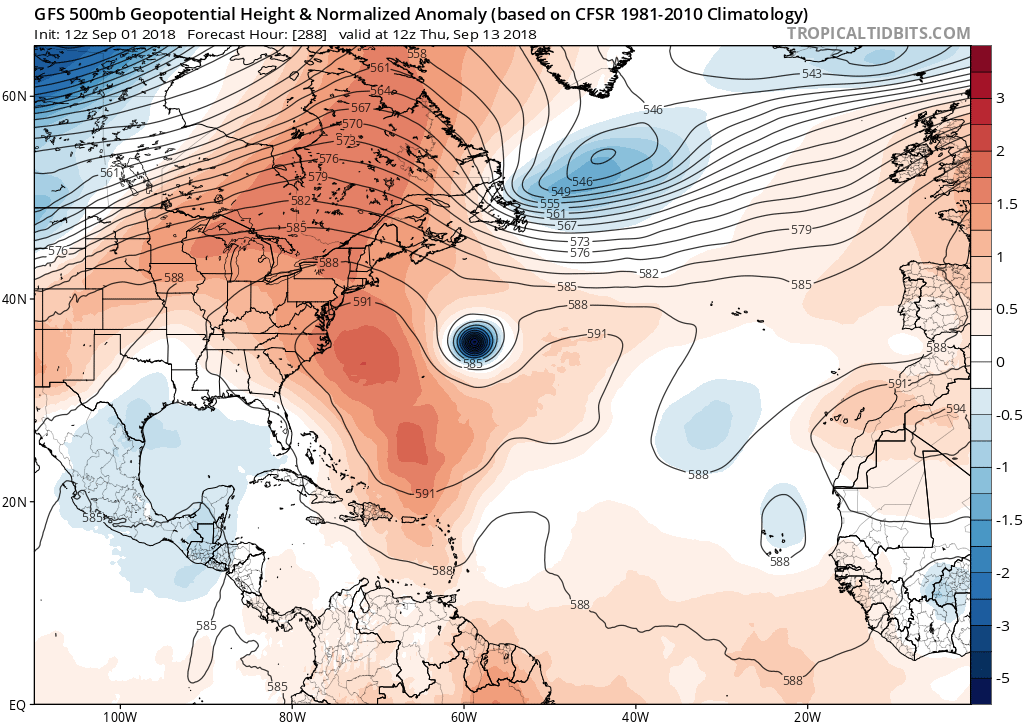
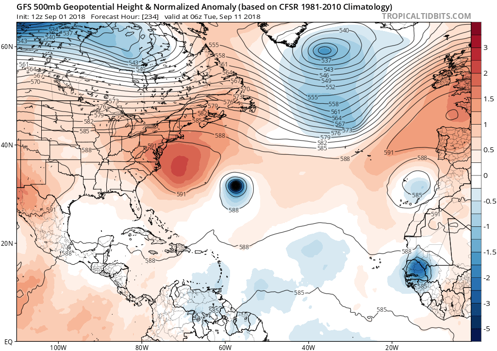
Wow the 12Z GFS lets Florence escape but barely this time. Look at that ridge building over SE Canada, not to mention it just misses getting underneath the building Bermuda High which would send it west or WSW at 234 hours (second image):
0 likes
-
Hypercane_Kyle

- Category 5

- Posts: 3465
- Joined: Sat Mar 07, 2015 7:58 pm
- Location: Cape Canaveral, FL
Re: ATL: FLORENCE - Models
Yeah, 12z GFS makes Florence significantly stronger through 192 hours, resulting in a more northward bias. ECMWF has a weaker system with a weaker trough, followed by a ridge building in that forces Florence west towards the US.
0 likes
My posts are my own personal opinion, defer to the National Hurricane Center (NHC) and other NOAA products for decision making during hurricane season.
-
AxaltaRacing24
- Category 5
- Posts: 1774
- Age: 25
- Joined: Wed Jul 27, 2016 11:14 am
- Location: Jupiter, FL
Re: ATL: FLORENCE - Models
Hypercane_Kyle wrote:Yeah, 12z GFS makes Florence significantly stronger through 192 hours, resulting in a more northward bias. ECMWF has a weaker system with a weaker trough, followed by a ridge building in that forces Florence west towards the US.
Classic GFS vs Euro situation. Going to be interesting to see how this plays out.
0 likes
-
Shell Mound
- Category 5
- Posts: 2432
- Age: 33
- Joined: Thu Sep 07, 2017 3:39 pm
- Location: St. Petersburg, FL → Scandinavia
Re: ATL: FLORENCE - Models
There is rather strong agreement among the 12Z GEFS ensemble members even in the long range. The trend is significantly farther W compared to 00Z:

Compare these runs to those of the most recent (00Z) EPS. There seems to be good agreement between the GEFS and EPS regarding a threat to Bermuda:

Compare these runs to those of the most recent (00Z) EPS. There seems to be good agreement between the GEFS and EPS regarding a threat to Bermuda:
Last edited by Shell Mound on Sat Sep 01, 2018 12:48 pm, edited 1 time in total.
0 likes
CVW / MiamiensisWx / Shell Mound
The posts in this forum are NOT official forecasts and should not be used as such. They are just the opinion of the poster and may or may not be backed by sound meteorological data. They are NOT endorsed by any professional institution or STORM2K. For official information, please refer to products from the NHC and NWS.
-
Hypercane_Kyle
- Category 5
- Posts: 3465
- Joined: Sat Mar 07, 2015 7:58 pm
- Location: Cape Canaveral, FL
Re: ATL: FLORENCE - Models
At least from what I've seen in the EPAC this season, especially with Lane, is that the ECMWF is consistently too weak and too far south.
0 likes
My posts are my own personal opinion, defer to the National Hurricane Center (NHC) and other NOAA products for decision making during hurricane season.
-
gatorcane
- S2K Supporter
- Posts: 23708
- Age: 48
- Joined: Sun Mar 13, 2005 3:54 pm
- Location: Boca Raton, FL
Re: ATL: FLORENCE - Models
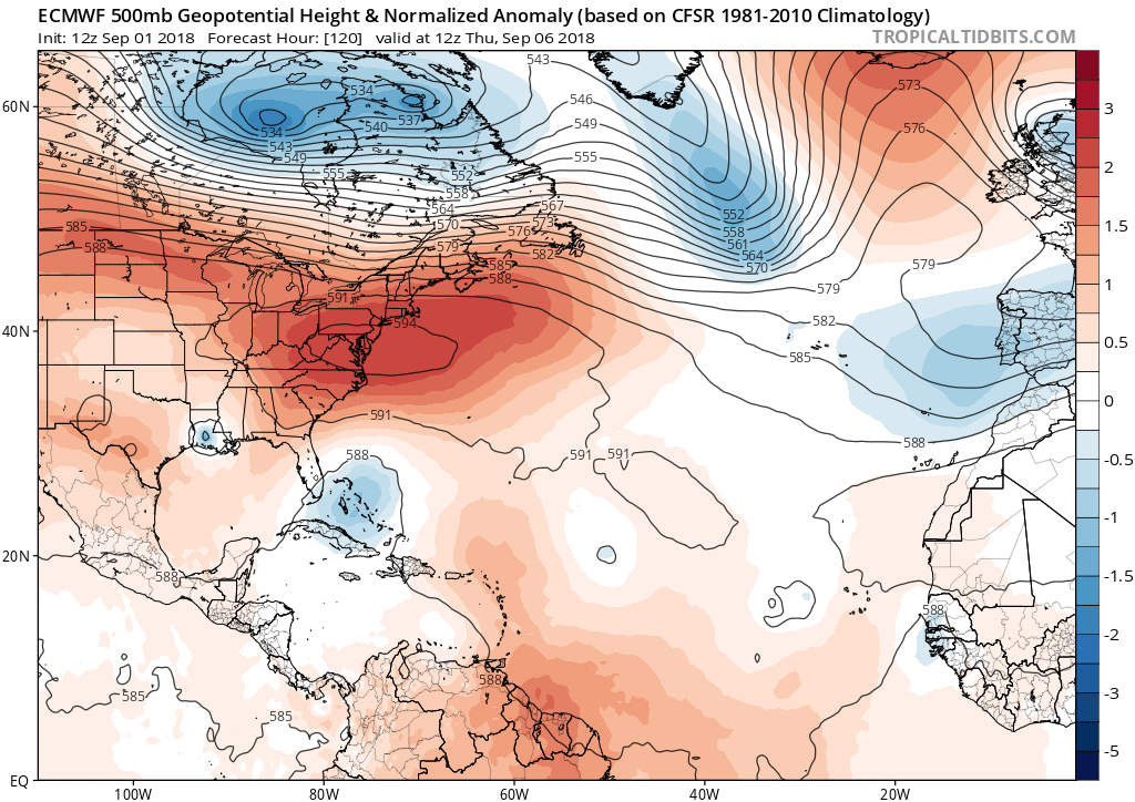
This setup at 120 hours on the 00Z ECMWF for Florence should drive it west or WNW. We will see how the run turns out:
0 likes
-
Hypercane_Kyle
- Category 5
- Posts: 3465
- Joined: Sat Mar 07, 2015 7:58 pm
- Location: Cape Canaveral, FL
Re: ATL: FLORENCE - Models
Looking like the 12z ECMWF will recurve Florence, ridge slightly weaker.
0 likes
My posts are my own personal opinion, defer to the National Hurricane Center (NHC) and other NOAA products for decision making during hurricane season.

-
bamajammer4eva
- Category 4

- Posts: 907
- Joined: Sun Apr 18, 2010 3:21 am
- Location: Ozark, AL
Re: ATL: FLORENCE - Models
Glad to know 00z run was a fluke with 12z back to showing safe recurve east of Bermuda

0 likes
-
TheStormExpert
Re: ATL: FLORENCE - Models
Looks like after this mornings brief Euro scare that consensus is growing that Florence will recurve near or east of Bermuda.
GFS

Euro

CMC

FV3-GFS

GFS
Euro
CMC
FV3-GFS
1 likes
-
Blown Away

- S2K Supporter
- Posts: 10253
- Joined: Wed May 26, 2004 6:17 am
Re: ATL: FLORENCE - Models
Still recurve, but continues to shift SW on each run.
0 likes
Hurricane Eye Experience: David 79, Irene 99, Frances 04, Jeanne 04, Wilma 05… Hurricane Brush Experience: Andrew 92, Erin 95, Floyd 99, Matthew 16, Irma 17, Ian 22, Nicole 22…
-
TheStormExpert
Re: ATL: FLORENCE - Models
Blown Away wrote:Still recurve, but continues to shift SW on each run.
What continues to shift SW? This was a big shift east from this mornings 00z run.
0 likes
-
Hypercane_Kyle
- Category 5
- Posts: 3465
- Joined: Sat Mar 07, 2015 7:58 pm
- Location: Cape Canaveral, FL
Re: ATL: FLORENCE - Models
End of 12z ECMWF is still kind of ominous with Florence; ridge builds in over it, heading changes from NNW to NW.
Still a lot of variables on the table, and these run-to-run changes are just showing us possibilities. As always, anything beyond 120 hours is not even worth really taking seriously.
Still a lot of variables on the table, and these run-to-run changes are just showing us possibilities. As always, anything beyond 120 hours is not even worth really taking seriously.
5 likes
My posts are my own personal opinion, defer to the National Hurricane Center (NHC) and other NOAA products for decision making during hurricane season.
Re: ATL: FLORENCE - Models
Hypercane_Kyle wrote:End of 12z ECMWF is still kind of ominous with Florence; ridge builds in over it, heading changes from NNW to NW.
Still a lot of variables on the table, and these run-to-run changes are just showing us possibilities. As always, anything beyond 120 hours is not even worth really taking seriously.
It gets uncomfortably close to Bermuda in this run also.
0 likes

Re: ATL: FLORENCE - Models
Boy, at least for the time being it's really gonna be an ebb and flow game of inches. So much dependent on how model run after run projection of the fluctuation of N.W. Atlantic mid level heights ultimately plays out. Timing really is everything as we watch model runs depicting each fairly quick moving short wave within the broader picture of a predominantly progressive zonal pattern over the Eastern CONUS. During so many past years we'd seem to have a long wave pattern that largely protected the Eastern Seaboard with each short wave trough that would drop into place there. Ah yes such were the Ninel Conde days.....
2 likes
Andy D
(For official information, please refer to the NHC and NWS products.)
(For official information, please refer to the NHC and NWS products.)
-
plasticup
Re: ATL: FLORENCE - Models
Hypercane_Kyle wrote:As always, anything beyond 120 hours is not even worth really taking seriously.
It's worth considering in the "this thing is possible, not garanteed" kind of way. You can think of the many models as showing the range of possibilities. Rarely does something happen that no model predicted.
0 likes

-
bamajammer4eva
- Category 4
- Posts: 907
- Joined: Sun Apr 18, 2010 3:21 am
- Location: Ozark, AL


Who is online
Users browsing this forum: No registered users and 25 guests