ATL: ISAAC - Models

Moderator: S2k Moderators

Message
Author
User avatar
Hurricaneman
Category 5
Category 5
Posts: 7284
Age: 43
Joined: Tue Aug 31, 2004 3:24 pm
Location: central florida

Re: ATL: INVEST 92L - Models

#81 Postby Hurricaneman » Thu Sep 06, 2018 12:08 am

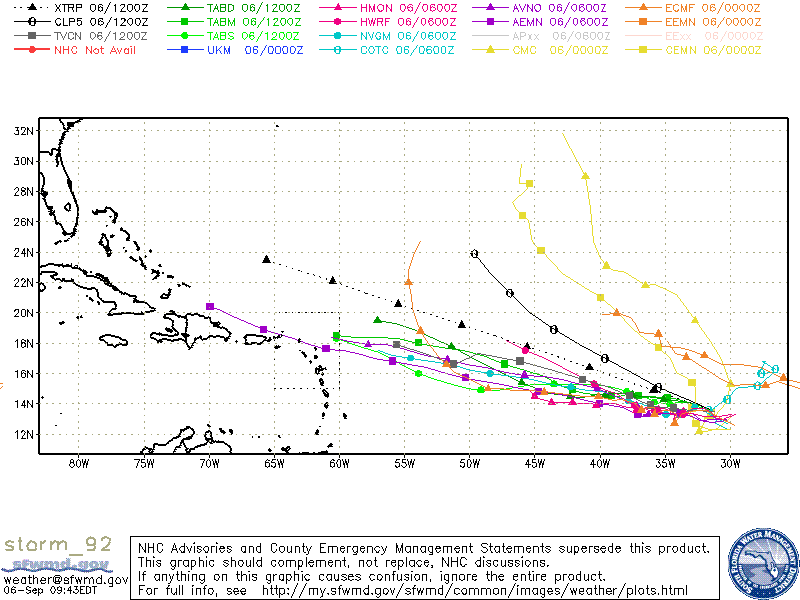
SoupBone wrote:Looking at it in motion, I think that's 92L that then regenerates and heads toward Florida.


Image


Yep right after going over Hispaniola and Cuba
1 likes   

User avatar
cycloneye
Admin
Admin
Posts: 139346
Age: 67
Joined: Thu Oct 10, 2002 10:54 am
Location: San Juan, Puerto Rico

Re: ATL: INVEST 92L - Models

#82 Postby cycloneye » Thu Sep 06, 2018 5:43 am

06Z GFS westward just north of PR.

Image
0 likes   
Visit the Caribbean-Central America Weather Thread where you can find at first post web cams,radars
and observations from Caribbean basin members Click Here

User avatar
cycloneye
Admin
Admin
Posts: 139346
Age: 67
Joined: Thu Oct 10, 2002 10:54 am
Location: San Juan, Puerto Rico

Re: ATL: INVEST 92L - Models

#83 Postby cycloneye » Thu Sep 06, 2018 5:58 am

Long range:

Image
0 likes   
Visit the Caribbean-Central America Weather Thread where you can find at first post web cams,radars
and observations from Caribbean basin members Click Here

User avatar
ronjon
Category 5
Category 5
Posts: 4671
Joined: Fri Aug 19, 2005 5:17 pm
Location: Hernando Beach, FL

Re: ATL: INVEST 92L - Models

#84 Postby ronjon » Thu Sep 06, 2018 5:59 am

92L rakes the greater antilles chain then up over SW FL to the SE US coast on the 06z GFS. Call it the cruise ship course? :D

https://www.tropicaltidbits.com/analysis/models/?model=gfs&region=atl&pkg=z850_vort&runtime=2018090606&fh=198
1 likes   

User avatar
stormchazer
Category 5
Category 5
Posts: 2458
Joined: Fri Aug 29, 2003 12:00 pm
Location: Lakeland, Florida
Contact:

Re: ATL: INVEST 92L - Models

#85 Postby stormchazer » Thu Sep 06, 2018 7:28 am

ronjon wrote:92L rakes the greater antilles chain then up over SW FL to the SE US coast on the 06z GFS. Call it the cruise ship course? :D

https://www.tropicaltidbits.com/analysis/models/?model=gfs&region=atl&pkg=z850_vort&runtime=2018090606&fh=198


Similar to the 0Z run from 24 hours ago. Interesting.
0 likes   
The posts or stuff said are NOT an official forecast and my opinion alone. Please look to the NHC and NWS for official forecasts and products.

Model Runs Cheat Sheet:
GFS (5:30 AM/PM, 11:30 AM/PM)
HWRF, GFDL, UKMET, NAVGEM (6:30-8:00 AM/PM, 12:30-2:00 AM/PM)
ECMWF (1:45 AM/PM)
TCVN is a weighted averaged

Opinions my own.

User avatar
wxGuy
Tropical Storm
Tropical Storm
Posts: 104
Joined: Thu Jun 14, 2018 1:50 pm

Re: ATL: INVEST 92L - Models

#86 Postby wxGuy » Thu Sep 06, 2018 7:29 am

I think Mr. GFS is too bullish on recurve right now, be back in 5 days :wink:
Florence could very well impact the East Coast. Which could keep this trucking more West.
0 likes   

User avatar
toad strangler
S2K Supporter
S2K Supporter
Posts: 4173
Joined: Sun Jul 28, 2013 3:09 pm
Location: Earth
Contact:

Re: ATL: INVEST 92L - Models

#87 Postby toad strangler » Thu Sep 06, 2018 7:43 am

6z "Test" FV3 GFS fishes 92L well before the Lesser Antilles. Florence sucking up the basin.
0 likes   

User avatar
Gustywind
Category 5
Category 5
Posts: 12334
Joined: Mon Sep 03, 2007 7:29 am
Location: Baie-Mahault, GUADELOUPE

Re: ATL: INVEST 92L - Models

#88 Postby Gustywind » Thu Sep 06, 2018 7:46 am

Agressive models guidance for intensity showing at least a cat 1 status during the next 72h and till cat 2 status at 120 h, even a bordeline cat 3 at 132 h.

https://www.tropicaltidbits.com/stormin ... latest.png
0 likes   

User avatar
toad strangler
S2K Supporter
S2K Supporter
Posts: 4173
Joined: Sun Jul 28, 2013 3:09 pm
Location: Earth
Contact:

Re: ATL: INVEST 92L - Models

#89 Postby toad strangler » Thu Sep 06, 2018 7:54 am

Since it hasn't been mentioned yet, the 00z Euro fishes 92L in roughly same spot as the "test" GFS. Same vacuum cleaner Florence reason.
0 likes   

User avatar
cycloneye
Admin
Admin
Posts: 139346
Age: 67
Joined: Thu Oct 10, 2002 10:54 am
Location: San Juan, Puerto Rico

Re: ATL: INVEST 92L - Models

#90 Postby cycloneye » Thu Sep 06, 2018 8:14 am

Image

Image
0 likes   
Visit the Caribbean-Central America Weather Thread where you can find at first post web cams,radars
and observations from Caribbean basin members Click Here

User avatar
AubreyStorm
Category 1
Category 1
Posts: 322
Age: 43
Joined: Fri Jun 16, 2017 6:21 pm
Location: Texas, USA

Re: ATL: INVEST 92L - Models

#91 Postby AubreyStorm » Thu Sep 06, 2018 8:34 am

:eek:

Image
0 likes   
The posts are NOT an official forecast. Please REFER to the NHC and NWS for official forecasts and products.

User avatar
TheStormExpert
Category 5
Category 5
Posts: 8487
Age: 30
Joined: Wed Feb 16, 2011 5:38 pm
Location: Palm Beach Gardens, FL

Re: ATL: INVEST 92L - Models

#92 Postby TheStormExpert » Thu Sep 06, 2018 8:39 am

:uarrow: Not looking good at all! The last thing those NE Caribbean Islands need is a tropical cyclone. Even the weakest of tropical cyclones could do some damage after what Irma and Maria did last year.
4 likes   
The following post is NOT an official forecast and should not be used as such. It is just the opinion of the poster and may or may not be backed by sound meteorological data. It is NOT endorsed by storm2k.org.

User avatar
TheStormExpert
Category 5
Category 5
Posts: 8487
Age: 30
Joined: Wed Feb 16, 2011 5:38 pm
Location: Palm Beach Gardens, FL

Re: ATL: INVEST 92L - Models

#93 Postby TheStormExpert » Thu Sep 06, 2018 8:46 am

4 likes   
The following post is NOT an official forecast and should not be used as such. It is just the opinion of the poster and may or may not be backed by sound meteorological data. It is NOT endorsed by storm2k.org.

User avatar
SoupBone
Category 5
Category 5
Posts: 3073
Joined: Tue Sep 20, 2005 5:24 pm

Re: ATL: INVEST 92L - Models

#94 Postby SoupBone » Thu Sep 06, 2018 8:48 am

The Euro still wants to send it out to sea. And the Euro performed great with Gordon...so I wouldn't discount it yet.

Image
0 likes   
Personal Forecast Disclaimer:
The posts in this forum are NOT official forecast and should not be used as such. They are just the opinion of the poster and may or may not be backed by sound meteorological data. They are NOT endorsed by any professional institution or storm2k.org. For official information, please refer to the NHC and NWS products.

User avatar
Kazmit
Category 5
Category 5
Posts: 1915
Age: 21
Joined: Mon Jul 25, 2016 8:49 am
Location: Williamsburg VA for college, Bermuda otherwise

Re: ATL: INVEST 92L - Models

#95 Postby Kazmit » Thu Sep 06, 2018 9:31 am

The models seem enthusiastic about this one. A hurricane seems likely, and I think a major is possible as well.
0 likes   
Igor 2010, Sandy 2012, Fay 2014, Gonzalo 2014, Joaquin 2015, Nicole 2016, Humberto 2019

I am only a tropical weather enthusiast. My predictions are not official and may or may not be backed by sound meteorological data. For official information, please refer to the NHC and NWS products.

User avatar
SoupBone
Category 5
Category 5
Posts: 3073
Joined: Tue Sep 20, 2005 5:24 pm

Re: ATL: INVEST 92L - Models

#96 Postby SoupBone » Thu Sep 06, 2018 11:26 am

At 168 (12Z GFS), it looks to be coming right on top of the islands.
1 likes   
Personal Forecast Disclaimer:
The posts in this forum are NOT official forecast and should not be used as such. They are just the opinion of the poster and may or may not be backed by sound meteorological data. They are NOT endorsed by any professional institution or storm2k.org. For official information, please refer to the NHC and NWS products.

User avatar
HurricaneEnzo
Category 2
Category 2
Posts: 724
Joined: Wed Mar 14, 2018 12:18 pm
Location: Newport, NC (Hurricane Alley)

Re: ATL: INVEST 92L - Models

#97 Postby HurricaneEnzo » Thu Sep 06, 2018 11:29 am


He probably has forgot than I will ever know about stuff like this and I hope he is right but I respectfully disagree with his assessment. The Caribbean wasn't favorable last year either (only a couple of weak systems) and we still got Irma, Jose, Maria. I guess Maria might count as Caribbean but extreme outskirts of. He also proclaimed peak season would be dead last year. I'm not trying to knock him just saying I wouldn't be proclaming something like that quite yet. Nobody thought Florence would be a Cat 4 where it was. Just saying no one should let their guard down because of that post.
3 likes   
Bertha 96' - Fran 96' - Bonnie 98' - Dennis 99' - Floyd 99' - Isabel 03' - Alex 04' - Ophelia 05' - Irene 11' - Arthur 14' - Matthew 16' - Florence 18' - Dorian 19' - Isaias 20' (countless other tropical storms and Hurricane swipes)

I am not a Professional Met just an enthusiast. Get your weather forecasts from the Pros!

User avatar
cycloneye
Admin
Admin
Posts: 139346
Age: 67
Joined: Thu Oct 10, 2002 10:54 am
Location: San Juan, Puerto Rico

Re: ATL: INVEST 92L - Models

#98 Postby cycloneye » Thu Sep 06, 2018 11:53 am

Caribbean cruiser.

Image
0 likes   
Visit the Caribbean-Central America Weather Thread where you can find at first post web cams,radars
and observations from Caribbean basin members Click Here

canes92
Tropical Depression
Tropical Depression
Posts: 97
Age: 31
Joined: Tue Mar 06, 2018 1:51 pm

Re: ATL: INVEST 92L - Models

#99 Postby canes92 » Thu Sep 06, 2018 12:06 pm

Looks like it tries to jump north at the end towards Cuba and Florida.
0 likes   

User avatar
chris_fit
Category 5
Category 5
Posts: 3078
Joined: Wed Sep 10, 2003 11:58 pm
Location: Tampa Bay Area, FL
Contact:

Re: ATL: INVEST 92L - Models

#100 Postby chris_fit » Thu Sep 06, 2018 12:08 pm

canes92 wrote:Looks like it tries to jump north at the end towards Cuba and Florida.


Plows through the Yucatan and into the BoC

Image
0 likes   


Return to “2018”

Who is online

Users browsing this forum: No registered users and 6 guests