
TPPN10 PGTW 300633
A. TYPHOON 03W (JELAWAT)
B. 30/0530Z
C. 16.15N
D. 138.05E
E. THREE/HMWRI8
F. T6.0/6.0/D3.0/24HRS STT: D0.5/03HRS
G. IR/EIR
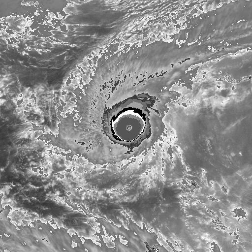
H. REMARKS: 09A/PBO RAGGED EYE/ANMTN. OW EYE SURROUNDED BY CMG
YIELDS AN E# OF 6.5. ADDED 0.5 FOR EYE ADJUSTMENT TO YIELD A DT
OF 7.0. MET YIELDS 5.0, AND AN ADJUSTMENT TO THE MET YIELDS
6.0. DBO PT. HAD TO BREAK CONSTRAINT OF LIMITING DEVELOPMENT OF
TO 2.5 OVER 24HRS DUE TO RAPID INTENSIFICATION.
I. ADDITIONAL POSITIONS:
30/0410Z 16.02N 137.80E ATMS
LOWE
WPAC: JELAWAT - Post-Tropical
Moderator: S2k Moderators
Re: WPAC: JELAWAT - Typhoon
0 likes
Remember, all of my post aren't official. For official warnings and discussions, Please refer to your local NWS products...
NWS for the Western Pacific
https://www.weather.gov/gum/
NWS for the Western Pacific
https://www.weather.gov/gum/
Re: WPAC: JELAWAT - Typhoon
Really sucks to rely on Dvorak on this kind of strong cyclone. I remember Irma got upgraded to a 5 when it had a classification of 6.0 which Jelawat is at now. Jelawat is much more impressive convection wise.
1 likes
Remember, all of my post aren't official. For official warnings and discussions, Please refer to your local NWS products...
NWS for the Western Pacific
https://www.weather.gov/gum/
NWS for the Western Pacific
https://www.weather.gov/gum/
-
StruThiO

- Category 3

- Posts: 821
- Age: 24
- Joined: Fri Sep 15, 2017 5:51 am
- Location: Currently Portland, OR. Raised in Jax, FL.
Re: WPAC: JELAWAT - Typhoon
UW - CIMSS
ADVANCED DVORAK TECHNIQUE
ADT-Version 8.2.1
Tropical Cyclone Intensity Algorithm
----- Current Analysis -----
Date : 30 MAR 2018 Time : 081000 UTC
Lat : 16:27:44 N Lon : 138:28:02 E
CI# /Pressure/ Vmax
5.5 / 953.8mb/102.0kt
Final T# Adj T# Raw T#
5.5 5.5 7.3
Estimated radius of max. wind based on IR : 8 km
Center Temp : +0.5C Cloud Region Temp : -82.1C
Scene Type : EYE
Positioning Method : SPIRAL ANALYSIS
Ocean Basin : WEST PACIFIC
Dvorak CI > MSLP Conversion Used : CKZ Method
Tno/CI Rules : Constraint Limits : 1.7T/6hr
Weakening Flag : OFF
Rapid Dissipation Flag : OFF
C/K/Z MSLP Estimate Inputs :
- Average 34 knot radii : 120km
- Environmental MSLP : 1006mb
Satellite Name : HIM-8
Satellite Viewing Angle : 19.5 degrees
0 likes


Re: WPAC: JELAWAT - Typhoon
Really exploded big time. Category 5!
TPPN10 PGTW 300923
A. TROPICAL CYCLONE 03W (JELAWAT)
B. 30/0900Z
C. 16.51N
D. 138.55E
E. THREE/HMWRI8
F. T7.0/7.0/D3.5/24HRS STT: D1.0/03HRS
G. IR/EIR
H. REMARKS: 09A/PBO RAGGED EYE/ANMTN. DG EYE SURROUNDED BY CMG
YIELDS AN E# OF 6.5. ADDED 0.5 FOR EYE ADJUSTMENT TO YIELD A DT
OF 7.0. MET YIELDS 4.5 AN PT YIELDS 6.0. DUE TO INTENSE AND
RAPID INTENSIFICATION OVER THE PAST 12-24 HRS CONSTRAINTS WERE
BROKEN TO BE MORE REPRESENTATIVE OF THE CURRENT STATE OF THE
SYSTEM. DBO DT.
I. ADDITIONAL POSITIONS:
30/0410Z 16.02N 137.80E ATMS
LOWE
0 likes
Remember, all of my post aren't official. For official warnings and discussions, Please refer to your local NWS products...
NWS for the Western Pacific
https://www.weather.gov/gum/
NWS for the Western Pacific
https://www.weather.gov/gum/
Re: WPAC: JELAWAT - Typhoon
Digital-TC-Chaser wrote:
115 looks good to me.
SSD is not updating. Those images are old.
0 likes
Remember, all of my post aren't official. For official warnings and discussions, Please refer to your local NWS products...
NWS for the Western Pacific
https://www.weather.gov/gum/
NWS for the Western Pacific
https://www.weather.gov/gum/
-
StruThiO
- Category 3
- Posts: 821
- Age: 24
- Joined: Fri Sep 15, 2017 5:51 am
- Location: Currently Portland, OR. Raised in Jax, FL.
Re: WPAC: JELAWAT - Typhoon
Such a different start from last season! WPAC just made my next few months interesting
0 likes
-
Digital-TC-Chaser


-
doomhaMwx

- Category 5

- Posts: 2398
- Age: 25
- Joined: Tue Apr 18, 2017 4:01 am
- Location: Baguio/Benguet, Philippines
- Contact:
Re: WPAC: JELAWAT - Typhoon
JMA gave 80kts(10-min) 955mb @ 09Z.
0 likes
Like my content? Consider giving a tip.
Re: WPAC: JELAWAT - Typhoon
Looks to be 150 to 160 knots.
0 likes
Remember, all of my post aren't official. For official warnings and discussions, Please refer to your local NWS products...
NWS for the Western Pacific
https://www.weather.gov/gum/
NWS for the Western Pacific
https://www.weather.gov/gum/
-
Digital-TC-Chaser
Re: WPAC: JELAWAT - Typhoon
Advanced Dvorak Technique (ADT)
Version 8.2.1
Tropical Cyclone Intensity Estimation Algorithm
RSMC Initialized
Current Intensity Analysis
UW - CIMSS
ADVANCED DVORAK TECHNIQUE
ADT-Version 8.2.1
Tropical Cyclone Intensity Algorithm
----- Current Analysis -----
Date : 30 MAR 2018 Time : 101000 UTC
Lat : 16:34:46 N Lon : 138:40:33 E
CI# /Pressure/ Vmax
5.5 / 943.3mb/102.0kt
Final T# Adj T# Raw T#
5.5 5.6 7.1
Latitude bias adjustment to MSLP : +2.3mb
Estimated radius of max. wind based on IR :N/A km
Center Temp : -8.3C Cloud Region Temp : -81.3C
-8.3 still not warm enough.. 115 -120 kts for me.
1 likes
-
doomhaMwx
- Category 5
- Posts: 2398
- Age: 25
- Joined: Tue Apr 18, 2017 4:01 am
- Location: Baguio/Benguet, Philippines
- Contact:
Re: WPAC: JELAWAT - Typhoon
Impressive VIIRS satellite images of Typhoon Jelawat earlier today, as it was rapidly intensifying...
Day/Night DNB Imagery VIIRS
Enhanced Infrared (IR) VIIRS
03-30-2018 4:02am UTC


Day/Night DNB Imagery VIIRS
Enhanced Infrared (IR) VIIRS
03-30-2018 4:02am UTC
3 likes
Like my content? Consider giving a tip.
Re: WPAC: JELAWAT - Typhoon
03W JELAWAT 180330 1200 16.7N 139.0E WPAC 130 926
Cat 4 Super Typhoon Jelawat.
Cat 4 Super Typhoon Jelawat.
0 likes
Remember, all of my post aren't official. For official warnings and discussions, Please refer to your local NWS products...
NWS for the Western Pacific
https://www.weather.gov/gum/
NWS for the Western Pacific
https://www.weather.gov/gum/
Re: WPAC: JELAWAT - Typhoon

1 likes
Remember, all of my post aren't official. For official warnings and discussions, Please refer to your local NWS products...
NWS for the Western Pacific
https://www.weather.gov/gum/
NWS for the Western Pacific
https://www.weather.gov/gum/
-
doomhaMwx
- Category 5
- Posts: 2398
- Age: 25
- Joined: Tue Apr 18, 2017 4:01 am
- Location: Baguio/Benguet, Philippines
- Contact:
Re: WPAC: JELAWAT - Typhoon
JMA 12Z intensity estimate: 95kts(10-min), 935mb

TY 1803 (Jelawat)
Issued at 12:40 UTC, 30 March 2018
<Analysis at 12 UTC, 30 March>
Scale -
Intensity Very strong
Center position N16°50' (16.8°)
E139°00' (139.0°)
Direction and speed of movement ENE 20 km/h (11 kt)
Central pressure 935 hPa
Maximum wind speed near center 50 m/s (95 kt)
Maximum wind gust speed 70 m/s (135 kt)
≥ 50 kt wind area ALL 130 km (70 NM)
≥ 30 kt wind area N 330 km (180 NM)
S 280 km (150 NM)
0 likes
Like my content? Consider giving a tip.
-
StruThiO
- Category 3
- Posts: 821
- Age: 24
- Joined: Fri Sep 15, 2017 5:51 am
- Location: Currently Portland, OR. Raised in Jax, FL.
Re: WPAC: JELAWAT - Typhoon
https://twitter.com/RyanMaue/status/979714373009723392
Maue seems to agree.
euro6208 wrote:Looks to be 150 to 160 knots.
Maue seems to agree.
0 likes
-
1900hurricane

- Category 5
- Posts: 6044
- Age: 32
- Joined: Fri Feb 06, 2015 12:04 pm
- Location: Houston, TX
- Contact:
Re: WPAC: JELAWAT - Typhoon
The 130 kt peak intensity for Jelawat by JTWC actually looks to be in the acceptable range to me. DTs did climb as high as 7.5 at times, but based on some of my reanalysis on the stronger storms in the cold season, the DT may actually outplay the actual intensity. Alice '79 and Nelson '82 (images below, respectively) are the most notable examples. Despite instantaneous DTs that were pushing 8.0 at times, actual measured pressures were near 930 mb, and I ended up setting their peak intensities as upper end category 4 super typhoons thanks to KZC analysis based on their measured pressures.

5 likes
Contract Meteorologist. TAMU & MSST. Fiercely authentic, one of a kind. We are all given free will, so choose a life meant to be lived. We are the Masters of our own Stories.
Opinions expressed are mine alone.
Follow me on Twitter at @1900hurricane : Read blogs at https://1900hurricane.wordpress.com/
Opinions expressed are mine alone.
Follow me on Twitter at @1900hurricane : Read blogs at https://1900hurricane.wordpress.com/
-
mrbagyo

- Category 5
- Posts: 3614
- Age: 31
- Joined: Thu Apr 12, 2012 9:18 am
- Location: 14.13N 120.98E
- Contact:
Re: WPAC: JELAWAT - Typhoon
Clearly going downhill now.

3 likes
The posts in this forum are NOT official forecast and should not be used as such. They are just the opinion of the poster and may or may not be backed by sound meteorological data. They are NOT endorsed by any professional institution or storm2k.org. For official information, please refer to RSMC, NHC and NWS products.
Who is online
Users browsing this forum: No registered users and 41 guests