
SouthPAC: NORA - Tropical Cyclone
Moderator: S2k Moderators
-
SouthDadeFish

- Professional-Met

- Posts: 2835
- Joined: Thu Sep 23, 2010 2:54 pm
- Location: Miami, FL
- Contact:
Re: SouthPAC: NORA - Tropical Cyclone
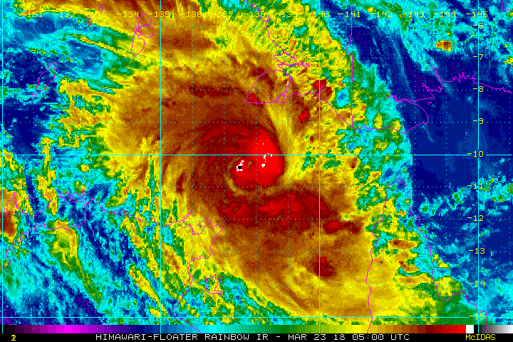
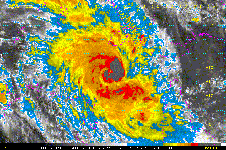
T 2.5!? That is a joke. It's quite likely Nora is undergoing RI at the moment. The classic cyan on 37-GHz color imagery can be seen. It's looking much better on IR imagery too.
1 likes
-
Digital-TC-Chaser
Re: SouthPAC: NORA - Tropical Cyclone
Details of Severe Tropical Cyclone Nora at 6:30 pm ACST:
Intensity: category 3, sustained winds near the centre of 120 kilometres per hour with wind gusts to 165 kilometres per hour.
Location: within 20 kilometres of 10.9 degrees South, 138.4 degrees East , 230 kilometres northeast of Nhulunbuy and 425 kilometres west northwest of Weipa .
Movement: southeast at 24 kilometres per hour .
Tropical Cyclone Nora has reached Category 3 strength. Nora has started taking a more southeasterly track, heading into the Gulf of Carpentaria.
The system is continuing to instensify and is expected to reach Category 4 during Saturday while over the northeast Gulf of Carpentaria. On Sunday, the Tropical Cyclone is expected to take a more southerly track and move close to the southeastern Gulf of Carpentaria coast, although a coastal crossing anywhere along the western Cape York Peninsula south of Mapoon during Saturday or Sunday is also quite possible.
Hazards:
The risk of GALES, with gusts to 110 kilometres per hour, is easing for the Northern Territory, but may develop in coastal areas between Elcho Island and Cape Shield, including Nhulunbuy, for a period tonight before midnight.
GALES with gusts to 110 kilometres per hour may develop in coastal areas between Thursday Island and Pormpuraaw, including Weipa, early on Saturday. Gales may extend south between Pormpuraaw and Gilbert River Mouth later on Saturday, and between Gilbert River Mouth and the NT/Qld Border, including Mornington Island, overnight Saturday and during Sunday.
DESTRUCTIVE WINDS with gusts to 155 kilometres per hour may develop in coastal areas between Thursday Island and Aurukun, including Weipa, during Saturday if the Tropical Cyclone continues to track east southeasterly. Destructive winds may develop between Aurukun and Pormpuraaw later on Saturday or early Sunday. VERY DESTRUCTIVE winds with gusts to 270 kilometres per hour may develop between Mapoon and Pormpuraaw, including Weipa, during Saturday, if the cyclone does not begin to track more southerly on Saturday.
HEAVY RAINFALL is forecast about Torres Strait and Cape York Peninsula in the coming days and may extend to the Gulf Country of Queensland late Saturday and into Sunday, depending on the track of the Tropical Cyclone. Heavy rainfall could potentially lead to flash flooding in some areas.
As the cyclone approaches the coast, a storm tide is expected between Mapoon and Gilbert River Mouth. Large waves may produce minor flooding along the foreshore. People living in areas likely to be affected by this flooding should take measures to protect their property as much as possible and be prepared to help their neighbours.
0 likes
-
1900hurricane

- Category 5

- Posts: 6044
- Age: 32
- Joined: Fri Feb 06, 2015 12:04 pm
- Location: Houston, TX
- Contact:
Re: SouthPAC: NORA - Tropical Cyclone
Yeah, that SAB estimate is the worst I've seen in a while. Why were they using 4 km data?
0 likes
Contract Meteorologist. TAMU & MSST. Fiercely authentic, one of a kind. We are all given free will, so choose a life meant to be lived. We are the Masters of our own Stories.
Opinions expressed are mine alone.
Follow me on Twitter at @1900hurricane : Read blogs at https://1900hurricane.wordpress.com/
Opinions expressed are mine alone.
Follow me on Twitter at @1900hurricane : Read blogs at https://1900hurricane.wordpress.com/
-
mrbagyo

- Category 5
- Posts: 3614
- Age: 31
- Joined: Thu Apr 12, 2012 9:18 am
- Location: 14.13N 120.98E
- Contact:
Re: SouthPAC: NORA - Tropical Cyclone
Wow, this thing is bombing out now. Just imagine how severe the storm surge threat from this one is goin to be given that it's forecast to funnel into the coast of Gulf of Carpentaria.
I think GoC is a relatively shallow body of water. Not good.
Nora has the potential to be one of the Historic GoC spinners
I think GoC is a relatively shallow body of water. Not good.
Nora has the potential to be one of the Historic GoC spinners
0 likes
The posts in this forum are NOT official forecast and should not be used as such. They are just the opinion of the poster and may or may not be backed by sound meteorological data. They are NOT endorsed by any professional institution or storm2k.org. For official information, please refer to RSMC, NHC and NWS products.

Re: SouthPAC: NORA - Tropical Cyclone
Probably one of the more impressive cases of RI I have seen in a while. Frictional convergence helping maybe?
0 likes
Very useful information on the Dvorak Technique --
https://severe.worldweather.wmo.int/TCF ... kBeven.pdf
https://severe.worldweather.wmo.int/TCF ... kBeven.pdf
Re: SouthPAC: NORA - Tropical Cyclone
mrbagyo wrote:Wow, this thing is bombing out now. Just imagine how severe the storm surge threat from this one is goin to be given that it's forecast to funnel into the coast of Gulf of Carpentaria.
I think GoC is a relatively shallow body of water. Not good.
Nora has the potential to be one of the Historic GoC spinners
This is a great place for a TC to explode. Very few people live along the Gulf of Carpentaria
1 likes
-
Yellow Evan

- Professional-Met
- Posts: 15951
- Age: 25
- Joined: Fri Jul 15, 2011 12:48 pm
- Location: Henderson, Nevada/Honolulu, HI
- Contact:
Re: SouthPAC: NORA - Tropical Cyclone
Burst of convection has overshot the eye for now but this is likely a Category 3 hurricane, well on its way to Category 4 status.
0 likes
-
1900hurricane
- Category 5
- Posts: 6044
- Age: 32
- Joined: Fri Feb 06, 2015 12:04 pm
- Location: Houston, TX
- Contact:
Re: SouthPAC: NORA - Tropical Cyclone
Core structure has suddenly degraded. Not sure what happened.

0 likes
Contract Meteorologist. TAMU & MSST. Fiercely authentic, one of a kind. We are all given free will, so choose a life meant to be lived. We are the Masters of our own Stories.
Opinions expressed are mine alone.
Follow me on Twitter at @1900hurricane : Read blogs at https://1900hurricane.wordpress.com/
Opinions expressed are mine alone.
Follow me on Twitter at @1900hurricane : Read blogs at https://1900hurricane.wordpress.com/
-
Digital-TC-Chaser
Re: SouthPAC: NORA - Tropical Cyclone
Bom model accessR has this crossing the cape.
http://www.bom.gov.au/australia/charts/ ... ndex.shtml

Sat 12:10 EDT https://imgur.com/a/9F75T

https://imgur.com/a/E2dgB
http://www.bom.gov.au/australia/charts/ ... ndex.shtml
Sat 12:10 EDT https://imgur.com/a/9F75T
https://imgur.com/a/E2dgB
0 likes
-
Digital-TC-Chaser
Re: SouthPAC: NORA - Tropical Cyclone
IDD20020
TROPICAL CYCLONE TECHNICAL BULLETIN: AUSTRALIA - NORTHERN REGION
Issued by DARWIN TROPICAL CYCLONE WARNING CENTRE
at: 0230 UTC 24/03/2018
Name: Severe Tropical Cyclone Nora
Identifier: 22U
Data At: 0000 UTC
Latitude: 12.6S
Longitude: 140.0E
Location Accuracy: within 15 nm [30 km]
Movement Towards: southeast [130 deg]
Speed of Movement: 8 knots [14 km/h]
Maximum 10-Minute Wind: 85 knots [155 km/h]
Maximum 3-Second Wind Gust: 120 knots [220 km/h]
Central Pressure: 958 hPa
Radius of 34-knot winds NE quadrant: 70 nm [130 km]
Radius of 34-knot winds SE quadrant: 60 nm [110 km]
Radius of 34-knot winds SW quadrant: 60 nm [110 km]
Radius of 34-knot winds NW quadrant: 60 nm [110 km]
Radius of 48-knot winds NE quadrant: 45 nm [85 km]
Radius of 48-knot winds SE quadrant: 45 nm [85 km]
Radius of 48-knot winds SW quadrant: 45 nm [85 km]
Radius of 48-knot winds NW quadrant: 45 nm [85 km]
Radius of 64-knot winds: 25 nm [45 km]
Radius of Maximum Winds: 25 nm [45 km]
Dvorak Intensity Code: T4.5/5.0/D1.0/24 HRS STT: 0.0/6HRS
Pressure of outermost isobar: 1002 hPa
Radius of outermost closed isobar: 150 nm [280 km]
FORECAST DATA
Date/Time : Location : Loc. Accuracy: Max Wind : Central Pressure
[UTC] : degrees : nm [km]: knots[km/h]: hPa
+06: 24/0600: 13.4S 140.5E: 020 [040]: 090 [165]: 954
+12: 24/1200: 14.3S 140.9E: 035 [065]: 095 [175]: 948
+18: 24/1800: 15.0S 141.1E: 045 [085]: 100 [185]: 943
+24: 25/0000: 15.6S 141.1E: 060 [110]: 105 [195]: 940
+36: 25/1200: 16.3S 141.2E: 080 [145]: 095 [175]: 938
+48: 26/0000: 16.5S 141.2E: 100 [180]: 085 [155]: 950
+60: 26/1200: 16.6S 141.1E: 120 [220]: 075 [140]: 950
+72: 27/0000: 16.8S 141.0E: 135 [255]: 065 [120]: 960
+96: 28/0000: 17.7S 136.8E: 180 [335]: 035 [065]: 994
+120: 29/0000: 18.7S 129.9E: 270 [500]: 025 [045]: 1004
REMARKS:
In the last 6 hours, the satellite presentation of Nora depicted a cessation of
the intensification, with a decrease in the circularity and extent of deep
convection around the LLCC. CIMMS analysis showed a moderate increase in
vertical wind shear from about 10 to 15-20 knots at 18UTC, and there was
evidence of low/mid-level dry air on the TPW imagery. The good equatorward
poleward upper-level outflow also diminished, and the combination of these
factors led to a stalling of Nora's intensification. Latest shear analysis shows
a return to more favourable conditions, and poleward upper outflow remains
favourable and as a result an in increase in deep convection around the LLCC has
become apparent in the last couple of hours. Dry air intrusion remains an
inhibiting factor, and so there is a low likelihood of development faster than
the standard rate.
Confidence in the location of the LLCC is good, using a combination of
satellite, microwave and RADAR imagery. Recent movement has been towards the
east southeast.
Dvorak analysis has recently been based on persistence and curved band analysis
after the disappearance of Nora's eye. Analysis at 0000 UTC based on a visible
satellite curved band with wrap of 1.3 yielding DT of 4.5. MET=PAT of 4.5, CI
maintained at 5.0 due to rules related to recent weakening of a system.
Steering of Nora is currently dominated by the broadscale westerly flow to the
north of the system along with a mid-level ridge over the Coral Sea. This is
maintaining a generally southeast steerin flow, however, recent movement has a
stronger easterly component. Model guidance suggests a more southeasterly
direction of steering in the short/mid-term. A mid-latitude, mid-level trough
amplifies as it passes to the south on Monday and Tuesday, stalling the system,
most likely in the southeastern Gulf of Carpentaria. The trough moves east
during Tuesday, allowing a ridge to develop over eastern Australia, pushing the
system to the west.
While CIMMS analysis indicates that the equatorward outflow channel has already
weakened significantly, excellent outflow potential persists on the poleward
side of the system. With the upper trough over southern Australia weakening
further over the weekend, the upper divergence is likley to decrease over the
next few days.
The decreasingly favourable upper pattern and dry air intrusion is expected to
inhibit significant further development, however intensification to category 4
over the next 6-12 hours remains a reasonable possibility.
Nora's peak intensity is liley to remain at or below 100 knots, dependent on the
magnitude of dry air intrusion and land interaction in the next 12-36 hours.
Steady weakening is expected to commence during Sunday as Nora moves close to
the Cape York west coast.
0 likes
Who is online
Users browsing this forum: No registered users and 39 guests