ATL: ALBERTO - Post-Tropical
Moderator: S2k Moderators
-
Hypercane_Kyle

- Category 5

- Posts: 2900
- Joined: Sat Mar 07, 2015 7:58 pm
- Location: Cape Canaveral, FL
Re: ATL: INVEST 90L - Models
Euro's a tad more east but definitely stronger through 72 hours.
0 likes
My posts are my own personal opinion, defer to the National Hurricane Center (NHC) and other NOAA products for decision making during hurricane season.
-
gatorcane

- S2K Supporter

- Posts: 23499
- Age: 46
- Joined: Sun Mar 13, 2005 3:54 pm
- Location: Boca Raton, FL
Re: ATL: INVEST 90L - Models
That shift east puts the west coast of Florida in some nasty weather this weekend. Are the east shifts done is the question?
2 likes
-
Aric Dunn
- Category 5
- Posts: 21228
- Age: 41
- Joined: Sun Sep 19, 2004 9:58 pm
- Location: Ready for the Chase.
- Contact:
Re: ATL: INVEST 90L - Models
Looks like the Euro is about to swing wnw again..
0 likes
Note: If I make a post that is brief. Please refer back to previous posts for the analysis or reasoning. I do not re-write/qoute what my initial post said each time.
If there is nothing before... then just ask
Space & Atmospheric Physicist, Embry-Riddle Aeronautical University,
I believe the sky is falling...
If there is nothing before... then just ask
Space & Atmospheric Physicist, Embry-Riddle Aeronautical University,
I believe the sky is falling...
Re: ATL: INVEST 90L - Models
SEASON_CANCELED wrote:Bocadude85 wrote:boca wrote:UKMET is an unlikely outlier with 90L.
Not that I am buying into the UKMET solution, but it is one of the better performing models.
nailed irma's path over florida if i remember right
It most definitely did. I believe it was the most accurate or 2nd most accurate.
0 likes
-
SunnyThoughts
- Category 5
- Posts: 2263
- Joined: Wed Jul 09, 2003 12:42 pm
- Location: Pensacola, Florida
Re: ATL: INVEST 90L - Models
Do you guys think this has a chance to become a low end hurricane? I saw earlier in the thread where the last time a hurricane actually hit the US in May was in the 1800's if I remember correctly. Hopefully we don't see that happen. The rain is going to be enough to deal with concerning this system.
0 likes
-
CrazyC83
- Professional-Met

- Posts: 33393
- Joined: Tue Mar 07, 2006 11:57 pm
- Location: Deep South, for the first time!
Re: ATL: INVEST 90L - Models
This setup may be reminiscent of Debby 2012? Ridge blocking an inland path, but unclear which way it rides around?
0 likes
-
gatorcane
- S2K Supporter
- Posts: 23499
- Age: 46
- Joined: Sun Mar 13, 2005 3:54 pm
- Location: Boca Raton, FL
Re: ATL: INVEST 90L - Models
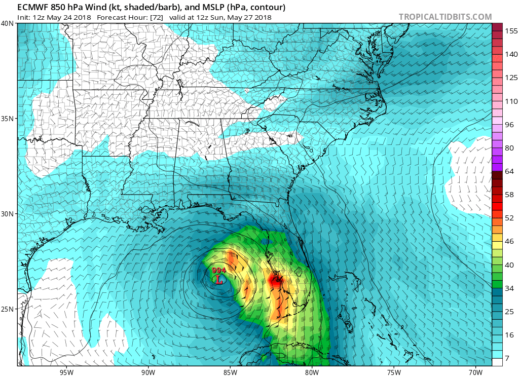
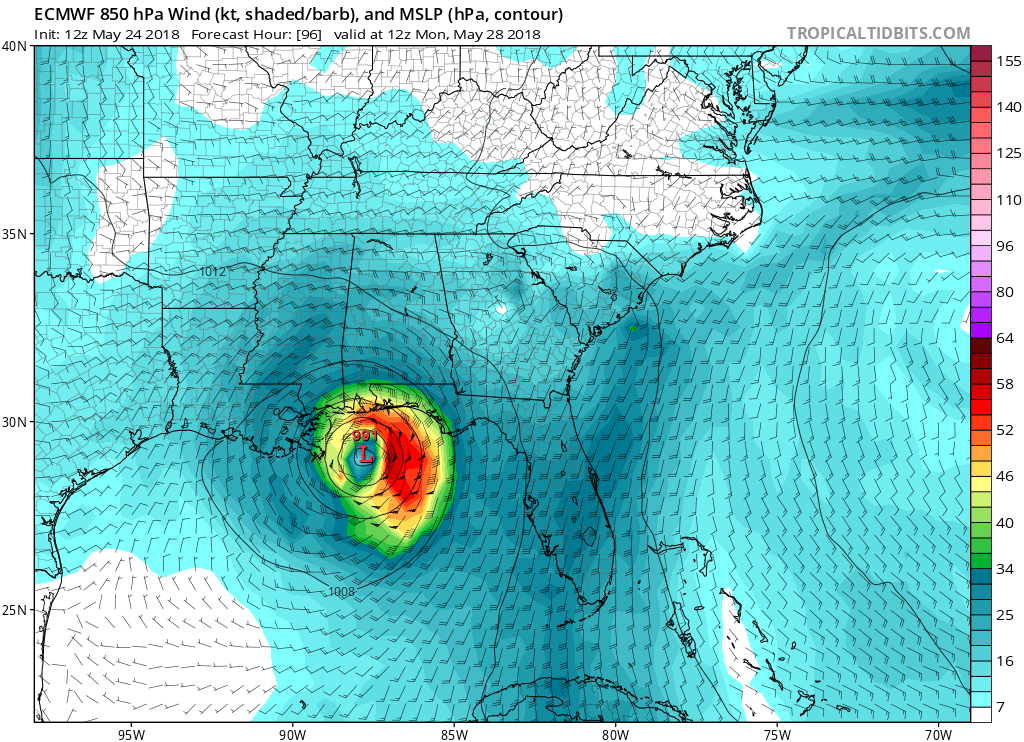
Wow Euro down to 991MB at hour 96 approaching northern Gulf coast
Last edited by gatorcane on Thu May 24, 2018 1:16 pm, edited 1 time in total.
0 likes
-
Aric Dunn
- Category 5
- Posts: 21228
- Age: 41
- Joined: Sun Sep 19, 2004 9:58 pm
- Location: Ready for the Chase.
- Contact:
Re: ATL: INVEST 90L - Models
man conditions rapidly change with the models all of a sudden from 72 to 96 hours.. it started to bomb out with the euro nearly a hurricane heading to NO
0 likes
Note: If I make a post that is brief. Please refer back to previous posts for the analysis or reasoning. I do not re-write/qoute what my initial post said each time.
If there is nothing before... then just ask
Space & Atmospheric Physicist, Embry-Riddle Aeronautical University,
I believe the sky is falling...
If there is nothing before... then just ask
Space & Atmospheric Physicist, Embry-Riddle Aeronautical University,
I believe the sky is falling...
-
cycloneye

- Admin

- Posts: 139127
- Age: 67
- Joined: Thu Oct 10, 2002 10:54 am
- Location: San Juan, Puerto Rico
Re: ATL: INVEST 90L - Models
Euro stronger and turns left.

0 likes
Visit the Caribbean-Central America Weather Thread where you can find at first post web cams,radars
and observations from Caribbean basin members Click Here
and observations from Caribbean basin members Click Here
Re: ATL: INVEST 90L - Models
blp wrote:gatorcane wrote:12Z UKMET shifts east and is weaker:
[]https://i.imgur.com/3EVsqkc.gif[/img]
The Ukie has earned its stripes in the past as a trend setter. I remember with IRMA it was one of the first to show a more westerly move toward the gulf. I did not verify but it started moving the other models in a trend in that direction. Interesting to see what happens.
That is correct. It's one that I now watch closely and is usually the western outlier so a bit concerning for us on the west coast
1 likes
-
Hypercane_Kyle
- Category 5
- Posts: 2900
- Joined: Sat Mar 07, 2015 7:58 pm
- Location: Cape Canaveral, FL
Re: ATL: INVEST 90L - Models
12z GFS and ECMWF look identical to each other in terms of position and strength at 96 hours. Looks to be a ~60-65mph TS.
0 likes
My posts are my own personal opinion, defer to the National Hurricane Center (NHC) and other NOAA products for decision making during hurricane season.
-
gatorcane
- S2K Supporter
- Posts: 23499
- Age: 46
- Joined: Sun Mar 13, 2005 3:54 pm
- Location: Boca Raton, FL
Re: ATL: INVEST 90L - Models
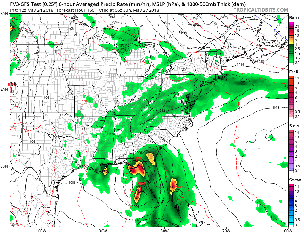
12Z FV3 GFS looks to have shifted west a tad but has a "hot mess" still scraping the west coast of Florida:
0 likes
-
gatorcane
- S2K Supporter
- Posts: 23499
- Age: 46
- Joined: Sun Mar 13, 2005 3:54 pm
- Location: Boca Raton, FL
Re: ATL: INVEST 90L - Discussion: Breaking News: STWO up to 70%-90%
looks like the models are zoning in on northern Gulf coast for landfall but what we have to watch is as the system makes the NE to NNE to N the NW turn in the Eastern Gulf (a reverse recurve so to speak), just how far east it gets. A center reformation or two to the east could mean a big difference as far as the impacts to the FL peninsula are concerned. It is not like the system is going to just head straight north into the Central GOM from the Yucatan.
1 likes
-
Aric Dunn
- Category 5
- Posts: 21228
- Age: 41
- Joined: Sun Sep 19, 2004 9:58 pm
- Location: Ready for the Chase.
- Contact:
Re: ATL: INVEST 90L - Models
Euro sim radar....hmmm

0 likes
Note: If I make a post that is brief. Please refer back to previous posts for the analysis or reasoning. I do not re-write/qoute what my initial post said each time.
If there is nothing before... then just ask
Space & Atmospheric Physicist, Embry-Riddle Aeronautical University,
I believe the sky is falling...
If there is nothing before... then just ask
Space & Atmospheric Physicist, Embry-Riddle Aeronautical University,
I believe the sky is falling...
-
Aric Dunn
- Category 5
- Posts: 21228
- Age: 41
- Joined: Sun Sep 19, 2004 9:58 pm
- Location: Ready for the Chase.
- Contact:
Re: ATL: INVEST 90L - Models
looks like 70 to 80 kts...
hmmmm

hmmmm
1 likes
Note: If I make a post that is brief. Please refer back to previous posts for the analysis or reasoning. I do not re-write/qoute what my initial post said each time.
If there is nothing before... then just ask
Space & Atmospheric Physicist, Embry-Riddle Aeronautical University,
I believe the sky is falling...
If there is nothing before... then just ask
Space & Atmospheric Physicist, Embry-Riddle Aeronautical University,
I believe the sky is falling...
-
CrazyC83
- Professional-Met
- Posts: 33393
- Joined: Tue Mar 07, 2006 11:57 pm
- Location: Deep South, for the first time!
Re: ATL: INVEST 90L - Models
Aric Dunn wrote:looks like 70 to 80 kts...
hmmmm
That's at about 100 m above the surface. That would be 50-60 kt at the surface.
2 likes
-
Ivanhater

- Storm2k Moderator

- Posts: 10852
- Age: 37
- Joined: Fri Jul 01, 2005 8:25 am
- Location: Pensacola
Re: ATL: INVEST 90L - Models
This is not looking like a nuisance..This could be bigger 
2 likes
Michael

Re: ATL: INVEST 90L - Discussion: Breaking News: STWO up to 70%-90%
gatorcane wrote:looks like the models are zoning in on northern Gulf coast for landfall but what we have to watch is as the system makes the NE to NNE to N the NW turn in the Eastern Gulf (a reverse recurve so to speak), just how far east it gets. A center reformation or two to the east could mean a big difference as far as the impacts to the FL peninsula are concerned. It is not like the system is going to just head straight north into the Central GOM from the Yucatan.
Pretty amazing agreement in the models now after being so far apart as recently as yesterday.
0 likes
-
Aric Dunn
- Category 5
- Posts: 21228
- Age: 41
- Joined: Sun Sep 19, 2004 9:58 pm
- Location: Ready for the Chase.
- Contact:
Re: ATL: INVEST 90L - Models
CrazyC83 wrote:Aric Dunn wrote:looks like 70 to 80 kts...
hmmmm
That's at about 100 m above the surface. That would be 50-60 kt at the surface.
with that structure... and partial eyewall I bet that would be working to the surface..
1 likes
Note: If I make a post that is brief. Please refer back to previous posts for the analysis or reasoning. I do not re-write/qoute what my initial post said each time.
If there is nothing before... then just ask
Space & Atmospheric Physicist, Embry-Riddle Aeronautical University,
I believe the sky is falling...
If there is nothing before... then just ask
Space & Atmospheric Physicist, Embry-Riddle Aeronautical University,
I believe the sky is falling...
-
SunnyThoughts
- Category 5
- Posts: 2263
- Joined: Wed Jul 09, 2003 12:42 pm
- Location: Pensacola, Florida
Re: ATL: INVEST 90L - Models
Ivanhater wrote:This is not looking like a nuisance..This could be bigger
Yeah Ivan, a little concern starting to creep in that its more than just rain someone is going to have to deal with.
0 likes
Who is online
Users browsing this forum: No registered users and 38 guests