txwatcher91 wrote:SFLcane wrote:I'am with gatorcane and find any well stacked low in the gulf highly suspect. Environment just looks awful. lol GFS 10+ inches across SFL EURO 2-4
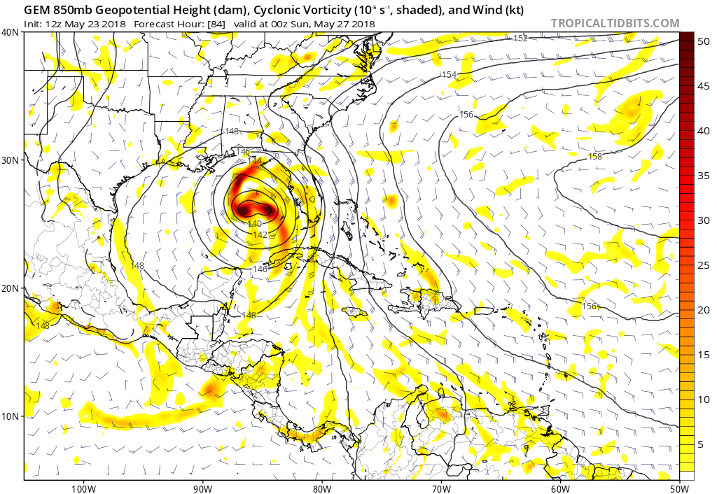
It's not hard to believe when models like the CMC and NAM are showing low 200-850mb shear over the system, almost nonexistent actually. Current shear has no bearing on what it will look like in a few days. Not saying CMC/NAM are right but this depiction by the CMC last night showed a nice setup for organization and stacking of the system.

Correct, current shear does not necessarily imply what might verify in 72-96 hours. If during the prime-time of the season and allied by more favorable convergent surface dynamics that would result in far greater convective development, i'd give greater credence to a budding tropical disturbance being able to better evolve it's own upper environment and attempt to better build a somewhat tilted (right sided) anticyclonic outflow channel. I'm not seeing those conditions being nearly as ideal especially given the relative mid to upper level westerlies over much of the gulf and marginal SST's.
Having said all that, I side with Gatorcane's thinking in terms of where development might best occur given the overall environment as we see/anticipate it to be. Based on that, I'm leaning toward a solution that more or less "marry's" the GFS with remaining Global suite models. Essentially I think that the weaker and more "east gulf" GFS has some merit, but just not as far east as recent runs have been indicating. The EURO, CMC, and NAM (did I just actually type NAM and EURO in the same sentence lol?) are implying a better co-location of a stacked COC and mid level circulation as the system nears the coast, but I just can't see that solution occurring west of Mobile. I'm thinking that we'll eventually see NHC tagging Invest Blob 97L , to "Tropical (Comma) Storm Alberto" primarily due to gradient induced winds on its east side over a fairly large swath of real estate. If the system is able to consolidate enough and perhaps become temporarily blocked offshore, that I can possibly see upper level conditions potentially improving just enough just offshore the Florida panhandle between Apalachicola and Pensacola to merit a true sub-tropical storm with 996/998 pressures. Sure, you'll need to be standing with a hand held anemometer on the top floor of an offshore tall building in the N. Gulf (not too many of those

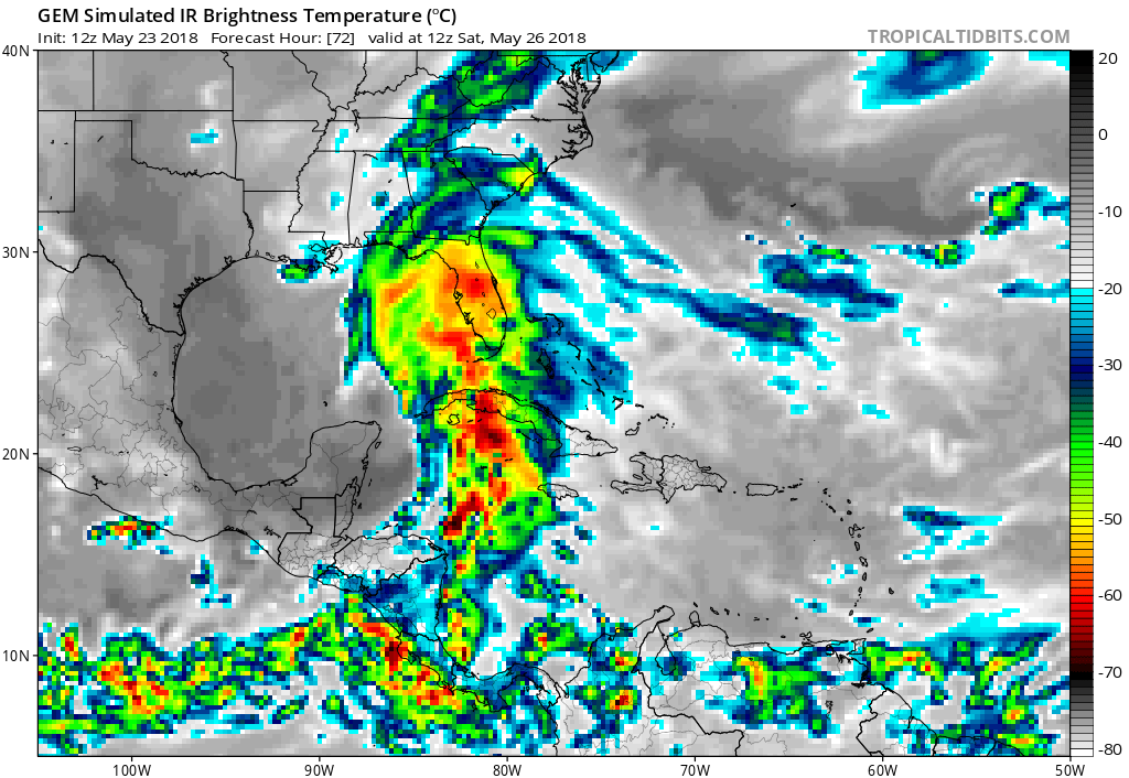
) to measure many quick gusts that exceed 55 mph, but hey.... while not particularly damaging to structures 25-35 knot winds along with high tides over a couple/few days can certainly push a lot of water and cause a whole lot of beach erosion. That would muck-up many small docks, undermine beach restoration projects, flood coastal roads and low bridges during high tide, and cause a bunch of people to consider moving or securing boats. Add potential rainfall dumps to the mix and you have one cruddy Chamber of Commerce weekends for points between Ceder Key and New Orleans. Bottom line, I don't see anything sub 999mb coming out of this blob (probably 1003mb at lowest) but I do anticipate it being named and eventually coming ashore at/near Ft. Walton Beach Fl. I'd take the EURO rain-shield maps and probably shove 'em about 150 miles to the east too. As for you folks in and around Tampa to the north-central Florida panhandle.... this might be a good time to check out craigslist for any cheap used kayaks.