ATL: ALBERTO - Post-Tropical
Moderator: S2k Moderators
-
galaxy401

- Category 5

- Posts: 2299
- Age: 28
- Joined: Sat Aug 25, 2012 9:04 pm
- Location: Casa Grande, Arizona
Re: ATL: ALBERTO - Sub Tropical Storm
Hearing reports that a news anchor and photojournalist from South Carolina were killed by a falling tree.
0 likes
Got my eyes on moving right into Hurricane Alley: Florida.
-
jaxfladude
- Category 5
- Posts: 1246
- Joined: Wed Aug 24, 2005 9:36 pm
- Location: Jacksonville, Fla
Re: RE: Re: ATL: ALBERTO - Sub Tropical Storm
Oh no!! Tragic news if confirmed 
galaxy401 wrote:Hearing reports that a news anchor and photojournalist from South Carolina were killed by a falling tree.
0 likes
Stay safe y'all

Re: ATL: ALBERTO - Sub Tropical Storm
No joke, but this is the first time I can unequivocally say that this storm appears tropical to me ( and that's after being post landfall)
1 likes
Personal Forecast Disclaimer:
The posts in this forum are NOT official forecast and should not be used as such. They are just the opinion of the poster and may or may not be backed by sound meteorological data. They are NOT endorsed by any professional institution or storm2k.org. For official information, please refer to the NHC and NWS products.
The posts in this forum are NOT official forecast and should not be used as such. They are just the opinion of the poster and may or may not be backed by sound meteorological data. They are NOT endorsed by any professional institution or storm2k.org. For official information, please refer to the NHC and NWS products.
-
cycloneye

- Admin

- Posts: 139041
- Age: 67
- Joined: Thu Oct 10, 2002 10:54 am
- Location: San Juan, Puerto Rico
Re: ATL: ALBERTO - Advisories
BULLETIN
Subtropical Storm Alberto Intermediate Advisory Number 15A
NWS National Hurricane Center Miami FL AL012018
700 PM CDT Mon May 28 2018
...WEAKENING ALBERTO MOVING FARTHER INLAND...
SUMMARY OF 700 PM CDT...0000 UTC...INFORMATION
----------------------------------------------
LOCATION...30.9N 86.1W
ABOUT 15 MI...20 KM N OF DEFUNIAK SPRINGS FLORIDA
MAXIMUM SUSTAINED WINDS...40 MPH...65 KM/H
PRESENT MOVEMENT...N OR 350 DEGREES AT 10 MPH...17 KM/H
MINIMUM CENTRAL PRESSURE...995 MB...29.38 INCHES
WATCHES AND WARNINGS
--------------------
CHANGES WITH THIS ADVISORY:
The Tropical Storm Warning west of the Okaloosa/Walton County line
to the Alabama/Florida border has been discontinued.
The Storm Surge Watch from the Aucilla River to Mexico Beach has
been discontinued.
SUMMARY OF WATCHES AND WARNINGS IN EFFECT:
A Tropical Storm Warning is in effect for...
* Aucilla River to the Okaloosa/Walton County line
For storm information specific to your area, including possible
inland watches and warnings, please monitor products issued by your
local National Weather Service forecast office.
DISCUSSION AND OUTLOOK
----------------------
At 700 PM CDT (0000 UTC), the center of Subtropical Storm Alberto
was located near latitude 30.9 North, longitude 86.1 West. The
storm is moving toward the north near 10 mph (17 km/h). A faster
northward to north-northwestward motion is expected during the next
few days. On the forecast track, the center of Alberto will move
over Alabama later tonight and early Tuesday. The system is
forecast to move over the Tennessee Valley on Tuesday and into the
Ohio Valley and Great Lakes region on Wednesday and Thursday.
Maximum sustained winds have decreased to near 40 mph (65 km/h) with
higher gusts. Continued weakening is forecast as Alberto moves
farther inland, and Alberto is expected to become a subtropical
depression later tonight, and degenerate into a remnant low by
Tuesday afternoon.
Winds of 40 mph extend outward up to 90 miles (150 km) from the
center.
The estimated minimum central pressure is 995 mb (29.38 inches).
HAZARDS AFFECTING LAND
----------------------
RAINFALL: Alberto is expected to produce the following rain
accumulations through Tuesday:
The Florida panhandle across eastern and central Alabama and western
Georgia...4 to 8 inches, isolated 12 inches.
The Florida Keys and Florida peninsula...Additional 1 to 2 inches,
isolated 5 inches.
Rest of the Southeast and Tennessee Valley into the lower mid
Atlantic from Tennessee east through the Carolinas...2 to 6 inches.
Flooding and flash flooding are possible in the southeast United
States, including Florida.
WIND: Tropical storm conditions will continue within portions of
the warning area for the next few hours.
STORM SURGE: Water levels along the northeast Gulf of Mexico coast
are receding, and will continue to do so overnight.
TORNADOES: Isolated tornadoes are possible through tonight over
parts of Georgia and southeast Alabama.
SURF: Swells generated by Alberto will continue to affect the
eastern and northern Gulf Coast through Tuesday. These swells are
likely to cause life-threatening surf and rip current conditions.
For more information, consult products from your local weather
office.
NEXT ADVISORY
-------------
Next complete advisory at 1000 PM CDT.
$$
Forecaster Pasch
0 likes
Visit the Caribbean-Central America Weather Thread where you can find at first post web cams,radars
and observations from Caribbean basin members Click Here
and observations from Caribbean basin members Click Here
-
NotSparta

- Professional-Met

- Posts: 1646
- Age: 22
- Joined: Fri Aug 18, 2017 8:24 am
- Location: Naples, FL
- Contact:
Re: ATL: ALBERTO - Sub Tropical Storm
How is this still subtropical?

2 likes
This post was probably an opinion of mine, and in no way is official. Please refer to http://www.hurricanes.gov for official tropical analysis and advisories.
My website, with lots of tropical wx graphics, including satellite and recon: http://cyclonicwx.com
My website, with lots of tropical wx graphics, including satellite and recon: http://cyclonicwx.com

Re: ATL: ALBERTO - Sub Tropical Storm
Just me or does it look like it’s moving more west than north?
1 likes
-
Sciencerocks
- Category 5
- Posts: 7282
- Age: 38
- Joined: Thu Jul 06, 2017 1:51 am
Re: ATL: ALBERTO - Sub Tropical Storm
NotSparta wrote:How is this still subtropical?
There's no way in hell that thing is subtropical and hasn't been for the past 18 hours.
3 likes
-
cycloneye
- Admin
- Posts: 139041
- Age: 67
- Joined: Thu Oct 10, 2002 10:54 am
- Location: San Juan, Puerto Rico
Re: ATL: ALBERTO - Sub Tropical Storm
I can see a revision to Tropical on post season analysis.
3 likes
Visit the Caribbean-Central America Weather Thread where you can find at first post web cams,radars
and observations from Caribbean basin members Click Here
and observations from Caribbean basin members Click Here

Re: RE: Re: ATL: ALBERTO - Sub Tropical Storm
jaxfladude wrote:Oh no!! Tragic news if confirmedgalaxy401 wrote:Hearing reports that a news anchor and photojournalist from South Carolina were killed by a falling tree.
It's confirmed:
http://www.wyff4.com/article/wyff-news- ... v/20945002
0 likes
-
Twisted-core
- Category 1

- Posts: 252
- Joined: Fri May 11, 2018 9:20 pm
Re: ATL: ALBERTO - Sub Tropical Storm
A good blog on this storm by cranky on the. 28th entry.
http://www.stormhamster.com/entry/e052818.htm
http://www.stormhamster.com/entry/e052818.htm
2 likes
-
northjaxpro

- S2K Supporter

- Posts: 8900
- Joined: Mon Sep 27, 2010 11:21 am
- Location: Jacksonville, FL
Re: ATL: ALBERTO - Sub Tropical Storm
Picked up over 2.5 inches in very heavy rain from a spiral band which moved right though the Jax area and my home . Total rainfall approaching 4.5 inches here in the past 24 hours.
These bands where they do move through are dumping torrential downpours for sure.
These bands where they do move through are dumping torrential downpours for sure.
1 likes
NEVER, EVER SAY NEVER in the tropics and weather in general, and most importantly, with life itself!!
________________________________________________________________________________________
Fay 2008 Beryl 2012 Debby 2012 Colin 2016 Hermine 2016 Julia 2016 Matthew 2016 Irma 2017 Dorian 2019
________________________________________________________________________________________
Fay 2008 Beryl 2012 Debby 2012 Colin 2016 Hermine 2016 Julia 2016 Matthew 2016 Irma 2017 Dorian 2019
-
AdamFirst

- S2K Supporter
- Posts: 2487
- Age: 34
- Joined: Thu Aug 14, 2008 10:54 am
- Location: Port Saint Lucie, FL
Re: ATL: ALBERTO - Sub Tropical Storm
northjaxpro wrote:Picked up over 2.5 inches in very heavy rain from a spiral band which moved right though the Jax area and my home . Total rainfall approaching 4.5 inches here in the past 24 hours.
These bands where they do move through are dumping torrential downpours for sure.
We had our share of bands come through Sunday - bone dry today though. A hazy, muggy day with a lot of high clouds. NWS Melbourne cancelled the flood watches in the southern CWA during the midday forecast package.
0 likes
Dolphins Marlins Canes Golden Panthers HEAT
Andrew 1992 - Irene 1999 - Frances 2004 - Jeanne 2004 - Wilma 2005 - Fay 2008 - Isaac 2012 - Matthew 2016 - Irma 2017 - Dorian 2019 - Ian 2022 - Nicole 2022
Andrew 1992 - Irene 1999 - Frances 2004 - Jeanne 2004 - Wilma 2005 - Fay 2008 - Isaac 2012 - Matthew 2016 - Irma 2017 - Dorian 2019 - Ian 2022 - Nicole 2022

Re: ATL: ALBERTO - Sub Tropical Storm
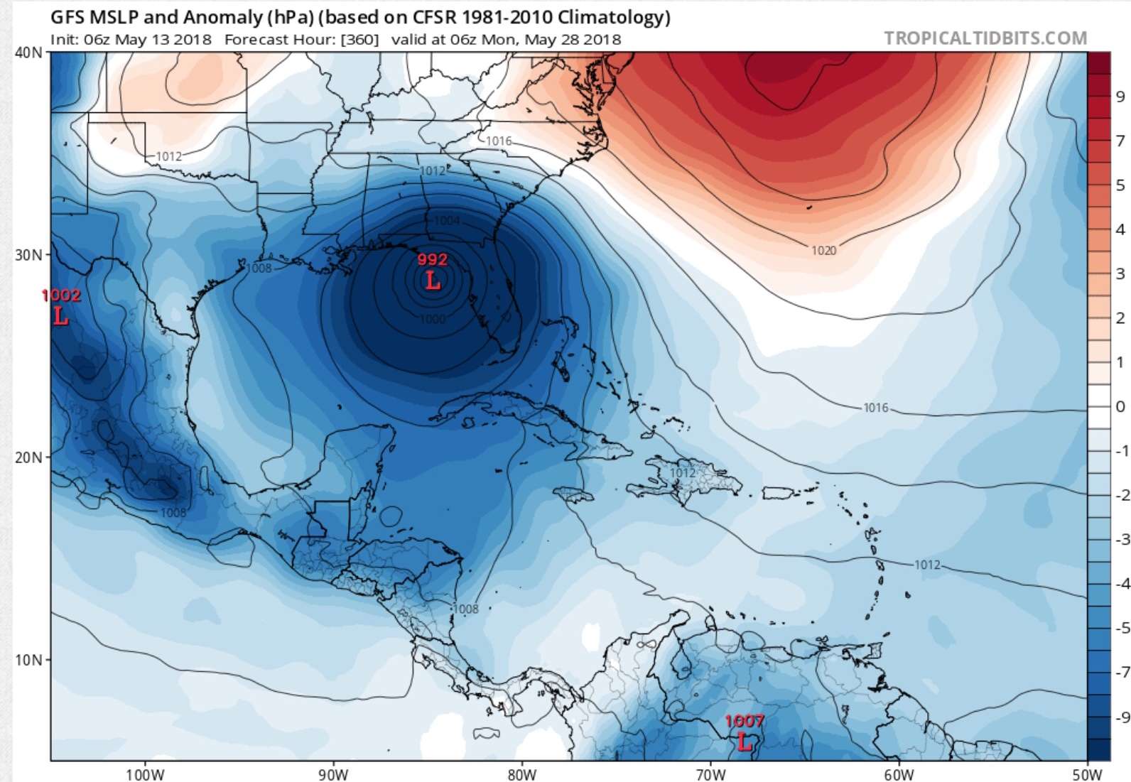
Image I saved from the 06z May 13 run of the GFS. Basically 15 hours and 2mb off:
10 likes
Re: ATL: ALBERTO - Sub Tropical Storm
N2FSU wrote:Image I saved from the 06z May 13 run of the GFS. Basically 15 hours and 2mb off:
That is freaking amazing!!!
5 likes
-
cycloneye
- Admin
- Posts: 139041
- Age: 67
- Joined: Thu Oct 10, 2002 10:54 am
- Location: San Juan, Puerto Rico
Re: ATL: ALBERTO - Advisories
BULLETIN
Subtropical Depression Alberto Advisory Number 16
NWS National Hurricane Center Miami FL AL012018
1000 PM CDT Mon May 28 2018
...ALBERTO WEAKENS TO A DEPRESSION...
...THREAT OF HEAVY RAINS CONTINUES...
SUMMARY OF 1000 PM CDT...0300 UTC...INFORMATION
-----------------------------------------------
LOCATION...31.4N 86.2W
ABOUT 50 MI...80 KM WNW OF DOTHAN ALABAMA
MAXIMUM SUSTAINED WINDS...35 MPH...55 KM/H
PRESENT MOVEMENT...N OR 350 DEGREES AT 12 MPH...19 KM/H
MINIMUM CENTRAL PRESSURE...996 MB...29.42 INCHES
WATCHES AND WARNINGS
--------------------
CHANGES WITH THIS ADVISORY:
The Tropical Storm Warning from the Aucilla River to the
Okaloosa/Walton County line has been discontinued.
SUMMARY OF WATCHES AND WARNINGS IN EFFECT:
There are no coastal watches or warnings in effect.
DISCUSSION AND OUTLOOK
----------------------
At 1000 PM CDT (0300 UTC), the center of Subtropical Depression
Alberto was located near latitude 31.4 North, longitude 86.2 West.
The depression is moving toward the north near 12 mph (19 km/h) A
faster northward to north-northwestward motion is expected during
the next few days. On the forecast track, the center of Alberto
will move over Alabama later tonight and early Tuesday. The system
is forecast to move over the Tennessee Valley on Tuesday and into
the Ohio Valley and Great Lakes region on Wednesday and Thursday.
Maximum sustained winds have decreased to near 35 mph (55 km/h) with
higher gusts. Continued weakening is forecast as Alberto moves
farther inland, and the system is expected to degenerate into a
remnant low by Tuesday evening.
The estimated minimum central pressure is 996 mb (29.42 inches).
HAZARDS AFFECTING LAND
----------------------
RAINFALL: Alberto is expected to produce 2 to 6 inches of rain from
Alabama to the western Great Lakes and from northern Florida to the
mid Atlantic coast through Wednesday. Isolated maximum totals of 12
inches are possible over the Florida Panhandle and Alabama. These
rains may produce flooding and flash flooding.
SURF: Swells generated by Alberto will continue to affect the
eastern and northern Gulf Coast through Tuesday. These swells are
likely to cause life-threatening surf and rip current conditions.
For more information, consult products from your local weather
office.
NEXT ADVISORY
-------------
Next intermediate advisory at 100 AM CDT.
Next complete advisory at 400 AM CDT.
$$
Forecaster Pasch
000
WTNT41 KNHC 290236
TCDAT1
Subtropical Depression Alberto Discussion Number 16
NWS National Hurricane Center Miami FL AL012018
1000 PM CDT Mon May 28 2018
Alberto's circulation continues to move farther inland, and is now
centered over southeastern Alabama. Surface synoptic observations
indicate that the system has weakened to a 30-kt subtropical
depression. Alberto will continue to weaken as it moves over land
during the next few days, and the system should degenerate into a
remnant low in 24 hours or sooner. The low is forecast to
dissipate in 96 hours but some of the guidance, such as the latest
run of the GFS, suggests that this event could occur sooner.
The depression is moving northward at a somewhat faster pace, or
350/10 kt. The track forecast philosophy has not changed
significantly. The cyclone should accelerate north-northwestward to
northward around the western periphery of a mid-level ridge to the
east and southeast over the next couple of days. After that, the
system should turn toward the north-northeast due to the influence
of the mid-latitude westerlies. The official track forecast is
close to the latest dynamical model consensus, TVCN, and is similar
to the previous NHC forecast.
KEY MESSAGES:
1. Heavy rainfall will lead to a significant risk of flash flooding
across the Florida Panhandle, much of Alabama, and western Georgia
overnight, spreading northward into northern Georgia, the
western Carolinas, and Tennessee on Tuesday.
2. Dangerous surf and rip current conditions will continue to
affect portions of the eastern and northern Gulf Coast through
Tuesday.
FORECAST POSITIONS AND MAX WINDS
INIT 29/0300Z 31.4N 86.2W 30 KT 35 MPH...INLAND
12H 29/1200Z 32.9N 86.7W 25 KT 30 MPH...INLAND
24H 30/0000Z 35.6N 87.3W 25 KT 30 MPH...POST-TROP/REMNT LOW
36H 30/1200Z 38.4N 87.3W 20 KT 25 MPH...POST-TROP/REMNT LOW
48H 31/0000Z 41.6N 86.2W 15 KT 15 MPH...POST-TROP/REMNT LOW
72H 01/0000Z 48.0N 81.0W 15 KT 15 MPH...POST-TROP/REMNT LOW
96H 02/0000Z...DISSIPATED
$$
Forecaster Pasch
0 likes
Visit the Caribbean-Central America Weather Thread where you can find at first post web cams,radars
and observations from Caribbean basin members Click Here
and observations from Caribbean basin members Click Here
Re: ATL: ALBERTO - Models
N2FSU wrote:May 13 GFS, valid for today at 2:00am:
That is freaking amazing!!!
0 likes
-
cycloneye
- Admin
- Posts: 139041
- Age: 67
- Joined: Thu Oct 10, 2002 10:54 am
- Location: San Juan, Puerto Rico
Re: ATL: ALBERTO - Sub Tropical Depression
...ALBERTO WEAKENS TO A DEPRESSION...
...THREAT OF HEAVY RAINS CONTINUES...
SUMMARY OF 1000 PM CDT...0300 UTC...INFORMATION
-----------------------------------------------
LOCATION...31.4N 86.2W
ABOUT 50 MI...80 KM WNW OF DOTHAN ALABAMA
MAXIMUM SUSTAINED WINDS...35 MPH...55 KM/H
PRESENT MOVEMENT...N OR 350 DEGREES AT 12 MPH...19 KM/H
MINIMUM CENTRAL PRESSURE...996 MB...29.42 INCHES
0 likes
Visit the Caribbean-Central America Weather Thread where you can find at first post web cams,radars
and observations from Caribbean basin members Click Here
and observations from Caribbean basin members Click Here
Re: ATL: ALBERTO - Models
caneman wrote:N2FSU wrote:May 13 GFS, valid for today at 2:00am:
That is freaking amazing!!!
15 hours and 2mb off!
1 likes
-
northjaxpro
- S2K Supporter
- Posts: 8900
- Joined: Mon Sep 27, 2010 11:21 am
- Location: Jacksonville, FL
Re: ATL: ALBERTO - Models
1 likes
NEVER, EVER SAY NEVER in the tropics and weather in general, and most importantly, with life itself!!
________________________________________________________________________________________
Fay 2008 Beryl 2012 Debby 2012 Colin 2016 Hermine 2016 Julia 2016 Matthew 2016 Irma 2017 Dorian 2019
________________________________________________________________________________________
Fay 2008 Beryl 2012 Debby 2012 Colin 2016 Hermine 2016 Julia 2016 Matthew 2016 Irma 2017 Dorian 2019
Who is online
Users browsing this forum: No registered users and 43 guests