
BoB: 95B - Post-Tropical
Moderator: S2k Moderators
-
doomhaMwx

- Category 5

- Posts: 2398
- Age: 25
- Joined: Tue Apr 18, 2017 4:01 am
- Location: Baguio/Benguet, Philippines
- Contact:
BoB: 95B - Post-Tropical
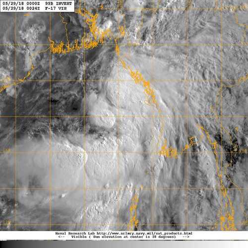
95B INVEST 180529 0000 17.6N 92.3E IO 30 997
Last edited by doomhaMwx on Wed May 30, 2018 8:23 pm, edited 2 times in total.
0 likes
Like my content? Consider giving a tip.
-
doomhaMwx
- Category 5
- Posts: 2398
- Age: 25
- Joined: Tue Apr 18, 2017 4:01 am
- Location: Baguio/Benguet, Philippines
- Contact:
Re: BoB: Invest 95B

THE AREA OF CONVECTION (INVEST 95B) PREVIOUSLY LOCATED
NEAR 14.2N 89.2E, IS NOW LOCATED NEAR 15.7N 90.9E, APPROXIMATELY 430
NM SOUTH-SOUTHEAST OF KOLKATA, INDIA. ANIMATED MULTISPECTRAL
SATELLITE IMAGERY AND A 281530Z MHS METOP-B 89GHZ MICROWAVE IMAGE
DEPICT A BROAD CIRCULATION WITH A BAND OF DISORGANIZED, FLARING
CONVECTION DISPLACED TO THE SOUTH. A 281531Z METOP-B PARTIAL ASCAT
PASS EMPHASIZES THAT THE SYSTEM IS DISORGANIZED WITH BROAD LOW LEVEL
TURNING. THE SYSTEM IS CURRENTLY LOCATED IN A FAVORABLE ENVIRONMENT
WITH EXCELLENT POLEWARD AND EQUATORWARD UPPER LEVEL DIVERGENCE, LOW
(5-15 KNOT) VERTICAL WIND SHEAR, AND VERY WARM (30-32 CELSIUS) SEA
SURFACE TEMPERATURES. GLOBAL MODELS DEPICT THE DISTURBANCE TRACKING
TO THE NORTHEAST AND REACHING LAND OVER THE NEXT 24 HOURS BUT ARE IN
DISAGREEMENT AS TO IF IT WILL CONSOLIDATE BEFORE MAKING LANDFALL
OVER NORTHERN MYANMAR. MAXIMUM SUSTAINED SURFACE WINDS ARE ESTIMATED
AT 15 TO 20 KNOTS. MINIMUM SEA LEVEL PRESSURE IS ESTIMATED TO BE
NEAR 1003 MB. THE POTENTIAL FOR THE DEVELOPMENT OF A SIGNIFICANT
TROPICAL CYCLONE WITHIN THE NEXT 24 HOURS REMAINS MEDIUM.
0 likes
Like my content? Consider giving a tip.
-
doomhaMwx
- Category 5
- Posts: 2398
- Age: 25
- Joined: Tue Apr 18, 2017 4:01 am
- Location: Baguio/Benguet, Philippines
- Contact:
Re: BoB: Invest 95B
Based on the latest ASCAT pass in the area, the system appears to be nearing or is at Tropical Storm intensity already.


0 likes
Like my content? Consider giving a tip.
-
doomhaMwx
- Category 5
- Posts: 2398
- Age: 25
- Joined: Tue Apr 18, 2017 4:01 am
- Location: Baguio/Benguet, Philippines
- Contact:
Re: BoB: Invest 95B
Regardless of strength, the main threat to Myanmar will be heavy rainfall.

0 likes
Like my content? Consider giving a tip.
-
doomhaMwx
- Category 5
- Posts: 2398
- Age: 25
- Joined: Tue Apr 18, 2017 4:01 am
- Location: Baguio/Benguet, Philippines
- Contact:
Re: BoB: Invest 95B

REMARKS:
THE AREA OF CONVECTION (INVEST 95B) PREVIOUSLY LOCATED
NEAR 15.7N 90.0E, IS NOW LOCATED NEAR 18.0N 92.0E, APPROXIMATELY 329
NM SOUTHEAST OF KOLKATA, INDIA. ANIMATED MULTISPECTRAL SATELLITE
IMAGERY AND A 290400Z MHS METOP-B 89GHZ MICROWAVE IMAGE DEPICT A
CONSOLIDATING LOW LEVEL CIRCULATION CENTER (LLCC) WITH DEEP
CONVECTION BUILDING OVER THE CENTER. A RECENT PARTIAL ASCAT PASS
SHOWS 25-30 KNOT WINDS BARBS LOCATED IN THE EASTERN QUADRANT.
ENVIRONMENTAL ANALYSIS SHOWS THE DISTURBANCE IS THE LOCATED IN AN
AREA OF LIGHT TO MODERATE (15-20 KNOTS) VERTICAL WIND SHEAR AND
FAVORABLE EQUATORWARD OUTFLOW. VERY WARM (30-32 CELSIUS) SEA SURFACE
TEMPERATURES WILL SUPPORT THE SYSTEM AS IS TRACKS TO THE NORTHEAST.
GLOBAL MODELS DEPICT THE DISTURBANCE TRACKING TO THE NORTHEAST BUT
ARE IN DISAGREEMENT AS TO IF IT WILL CONSOLIDATE AND REACH TROPICAL
CYCLONE STRENGTH BEFORE MAKING LANDFALL. MAXIMUM SUSTAINED SURFACE
WINDS ARE ESTIMATED AT 28 TO 33 KNOTS. MINIMUM SEA LEVEL PRESSURE IS
ESTIMATED TO BE NEAR 998 MB. THE POTENTIAL FOR THE DEVELOPMENT OF A
SIGNIFICANT TROPICAL CYCLONE WITHIN THE NEXT 24 HOURS IS HIGH.
0 likes
Like my content? Consider giving a tip.

Re: BoB: Invest 95B
OBVIOUS cyclone
IMD really needs to open their eyes and actually look at some data. This is not a well marked low. It is a tropical cyclone
IMD really needs to open their eyes and actually look at some data. This is not a well marked low. It is a tropical cyclone
1 likes
-
Sciencerocks
- Category 5
- Posts: 7282
- Age: 38
- Joined: Thu Jul 06, 2017 1:51 am
-
doomhaMwx
- Category 5
- Posts: 2398
- Age: 25
- Joined: Tue Apr 18, 2017 4:01 am
- Location: Baguio/Benguet, Philippines
- Contact:
Re: BoB: 95B - DEPRESSION
IMD
Sub: Depression over northeast and adjoining eastcentral Bay of Bengal
Latest observations and satellite imageries indicate that the Well Marked Low Pressure Area (WML) over eastcentral and adjoining northeast Bay of Bengal (BoB) has concentrated into a depression and lay centred at 1130 hrs IST of today, the 29th May 2018 over northeast and adjoining eastcentral BoB near latitude 18.50N and longitude 92.20E, about 170 km west-southwest of Kyaukpyu (Myanmar) and 190 km south-southwest of Sittwe (Myanmar). It is very likely to intensify further into a deep depression during next 6 hrs. It is very likely to move north-northeastwards and cross Myanmar and adjoining Bangladesh coasts between Kyaukpyu and Teknaf (Bangladesh) close to Sittwe around night of today, the 29th May 2018.
Latest observations and satellite imageries indicate that the Well Marked Low Pressure Area (WML) over eastcentral and adjoining northeast Bay of Bengal (BoB) has concentrated into a depression and lay centred at 1130 hrs IST of today, the 29th May 2018 over northeast and adjoining eastcentral BoB near latitude 18.50N and longitude 92.20E, about 170 km west-southwest of Kyaukpyu (Myanmar) and 190 km south-southwest of Sittwe (Myanmar). It is very likely to intensify further into a deep depression during next 6 hrs. It is very likely to move north-northeastwards and cross Myanmar and adjoining Bangladesh coasts between Kyaukpyu and Teknaf (Bangladesh) close to Sittwe around night of today, the 29th May 2018.
1 likes
Like my content? Consider giving a tip.
-
Twisted-core
- Category 1

- Posts: 252
- Joined: Fri May 11, 2018 9:20 pm
Re: BoB: 95B - DEPRESSION
Did someone here apply from a job with the IMD and get knocked back in the past.
These continuous anti IMD remarks season after season are boring .
.
These continuous anti IMD remarks season after season are boring
.
0 likes
-
Sciencerocks
- Category 5
- Posts: 7282
- Age: 38
- Joined: Thu Jul 06, 2017 1:51 am
Re: BoB: 95B - DEPRESSION
Twisted-core wrote:Did someone here apply from a job with the IMD and get knocked back in the past.
These continuous anti IMD remarks season after season are boring
Dude, the data says otherwise. In this field the data rules and when someone goes completely 100% against that data they're wrong.
That is a fact.
0 likes
-
Twisted-core
- Category 1
- Posts: 252
- Joined: Fri May 11, 2018 9:20 pm
Re: BoB: 95B - DEPRESSION
This storm is tagged deep depression.. http://www.rsmcnewdelhi.imd.gov.in/imag ... n/rsmc.pdf
The well marked low is another entity and there is nothing on meto suggesting a tc dude.

http://www.meteoearth.com/
The well marked low is another entity and there is nothing on meto suggesting a tc dude.
http://www.meteoearth.com/
0 likes
-
Sciencerocks
- Category 5
- Posts: 7282
- Age: 38
- Joined: Thu Jul 06, 2017 1:51 am
Re: BoB: 95B - DEPRESSION
Here in America we value others views and opinions(non-pro and pro-alike) and since this is an board for that I think it should be fine to state an differing opinion from the official agency. What fun would it be if we all had to mirror the official agency? Most of us wouldn't even be on this board if that was the case.
What is the point of even discussing such things if one has to treat the official agency like it is god? Do I respect them, yes, but I and the pro-met just disagree based on the data we see before us. That is the wonderful thing about Meteorology and that is the simple reality that new data can change everything.
What is the point of even discussing such things if one has to treat the official agency like it is god? Do I respect them, yes, but I and the pro-met just disagree based on the data we see before us. That is the wonderful thing about Meteorology and that is the simple reality that new data can change everything.
Last edited by Sciencerocks on Tue May 29, 2018 10:52 pm, edited 1 time in total.
0 likes
-
doomhaMwx
- Category 5
- Posts: 2398
- Age: 25
- Joined: Tue Apr 18, 2017 4:01 am
- Location: Baguio/Benguet, Philippines
- Contact:
Re: BoB: 95B - DEPRESSION
max Deep Depression by IMD...
Hmmm... The JTWC cancelled their TCFA and didn't issue numbered TC warnings, but this system was listed as 03B on NRL site.
03B THREE 180529 1200 19.4N 93.5E IO 30 996
03B THREE 180529 1800 20.6N 94.5E IO 30 1000
Deep Depression over Coastal Myanmar moved further northeastwards, weakened into a depression and lay centered at 0530 hrs IST of today, the 30th May 2018 over Myanmar near latitude 21.3°N and longitude 95.2 °E, about 30Km east-northeast of Nyaung-U and 120 Km southwest of Mandalay(Myanmar). It is very likely to continue to move northeastwards and weaken into a well marked low pressure area during next 12 hours.
Hmmm... The JTWC cancelled their TCFA and didn't issue numbered TC warnings, but this system was listed as 03B on NRL site.
03B THREE 180529 1200 19.4N 93.5E IO 30 996
03B THREE 180529 1800 20.6N 94.5E IO 30 1000
1 likes
Like my content? Consider giving a tip.
Re: BoB: 95B - DEPRESSION
Twisted-core wrote:Did someone here apply from a job with the IMD and get knocked back in the past.
These continuous anti IMD remarks season after season are boring
maybe if IMD did their job properly, the justified criticisms would not be required.
Missing OBVIOUS cyclones like this one is not becoming of an RSMC. They need to look at other info besides their own satellites and their own Dvorak estimates
2 likes
Re: BoB: 95B - DEPRESSION
Twisted-core wrote:This storm is tagged deep depression.. http://www.rsmcnewdelhi.imd.gov.in/imag ... n/rsmc.pdf
The well marked low is another entity and there is nothing on meto suggesting a tc dude.
http://www.meteoearth.com/
not a TC? Did you look at the data?
1 likes

Re: BoB: 95B - DEPRESSION
Looks alot better organized with deeper convection than Alberto...
1 likes
Remember, all of my post aren't official. For official warnings and discussions, Please refer to your local NWS products...
NWS for the Western Pacific
https://www.weather.gov/gum/
NWS for the Western Pacific
https://www.weather.gov/gum/
Re: BoB: 95B - DEPRESSION
Imran_doomhaMwx wrote:max Deep Depression by IMD...Deep Depression over Coastal Myanmar moved further northeastwards, weakened into a depression and lay centered at 0530 hrs IST of today, the 30th May 2018 over Myanmar near latitude 21.3°N and longitude 95.2 °E, about 30Km east-northeast of Nyaung-U and 120 Km southwest of Mandalay(Myanmar). It is very likely to continue to move northeastwards and weaken into a well marked low pressure area during next 12 hours.
Hmmm... The JTWC cancelled their TCFA and didn't issue numbered TC warnings, but this system was listed as 03B on NRL site.
03B THREE 180529 1200 19.4N 93.5E IO 30 996
03B THREE 180529 1800 20.6N 94.5E IO 30 1000
Read on the JTWC facebook that it was upgraded to 35 knots preliminary post analysis before landfall...
0 likes
Remember, all of my post aren't official. For official warnings and discussions, Please refer to your local NWS products...
NWS for the Western Pacific
https://www.weather.gov/gum/
NWS for the Western Pacific
https://www.weather.gov/gum/
Who is online
Users browsing this forum: No registered users and 81 guests