WPAC: EWINIAR - Post-Tropical

Moderator: S2k Moderators

Message
Author
User avatar
cycloneye
Admin
Admin
Posts: 139019
Age: 67
Joined: Thu Oct 10, 2002 10:54 am
Location: San Juan, Puerto Rico

WPAC: EWINIAR - Post-Tropical

#1 Postby cycloneye » Wed May 30, 2018 8:02 pm

Location: 9.3°N 119.6°E
Maximum Winds: 15 kt
Minimum Central Pressure: N/A

Image
0 likes   
Visit the Caribbean-Central America Weather Thread where you can find at first post web cams,radars
and observations from Caribbean basin members Click Here

User avatar
NotSparta
Professional-Met
Professional-Met
Posts: 1645
Age: 22
Joined: Fri Aug 18, 2017 8:24 am
Location: Naples, FL
Contact:

Re: WPAC: INVEST 99W

#2 Postby NotSparta » Wed May 30, 2018 8:11 pm

Image
0 likes   
This post was probably an opinion of mine, and in no way is official. Please refer to http://www.hurricanes.gov for official tropical analysis and advisories.

My website, with lots of tropical wx graphics, including satellite and recon: http://cyclonicwx.com

User avatar
euro6208
Category 5
Category 5
Posts: 18547
Joined: Mon Mar 08, 2004 7:50 pm
Location: Guam

Re: WPAC: INVEST 99W

#3 Postby euro6208 » Wed May 30, 2018 8:55 pm

GFS and EURO now in good agreement on a track towards Northern Hainan Island and Leizhou Peninsula southern China.
0 likes   
Remember, all of my post aren't official. For official warnings and discussions, Please refer to your local NWS products...

NWS for the Western Pacific

https://www.weather.gov/gum/

User avatar
euro6208
Category 5
Category 5
Posts: 18547
Joined: Mon Mar 08, 2004 7:50 pm
Location: Guam

Re: WPAC: INVEST 99W

#4 Postby euro6208 » Wed May 30, 2018 11:51 pm

00z GFS shifts back to the right. Makes landfall west of Hong Kong...911mb.
0 likes   
Remember, all of my post aren't official. For official warnings and discussions, Please refer to your local NWS products...

NWS for the Western Pacific

https://www.weather.gov/gum/

aperson
S2K Supporter
S2K Supporter
Posts: 336
Age: 35
Joined: Thu Sep 22, 2005 10:56 pm

Re: WPAC: INVEST 99W

#5 Postby aperson » Thu May 31, 2018 2:08 am

While 00z ECMWF came in further west than 00z GFS, they both had a similar Fujiwhara interaction with 90W alongside 5H heights blocking poleward movement. This results in both models showing an extended stall near the Leizhou peninsula. These two runs have drastically different intensity guidance, however.
0 likes   

User avatar
euro6208
Category 5
Category 5
Posts: 18547
Joined: Mon Mar 08, 2004 7:50 pm
Location: Guam

Re: WPAC: INVEST 99W

#6 Postby euro6208 » Thu May 31, 2018 2:17 am

LOW.

AN AREA OF CONVECTION (INVEST 99W) HAS PERSISTED NEAR 9.0N
119.6E, APPROXIMATELY 75 NM SOUTHEAST OF PUERTO PRINCESA,
PHILIPPINES. ANIMATED MULTISPECTRAL SATELLITE IMAGERY SHOWS A BROAD
CIRCULATION WITH LARGE AREAS OF FLARING CONVECTION LOCATED ON ALL
SIDES. A 310140Z MHS 89GHZ MICROWAVE IMAGE SHOWS AN ELONGATED
CIRCULATION WITH DISORGANIZED AND SHALLOW FLARING CONVECTION. THE
DISTURBANCE IS CURRENTLY LOCATED IN AN AREA OF GOOD EQUATORWARD
UPPER LEVEL OUTFLOW, LOW VERTICAL WIND SHEAR (5-15 KNOTS), AND VERY
WARM SEA SURFACE TEMPERATURES (31+ CELSIUS). GLOBAL MODELS ARE IN
AGREEMENT THAT THE SYSTEM WILL EVENTUALLY TRACK TO THE NORTHWEST,
BUT NONE ARE IN AGREEMENT HOW FAST IT WILL BEGIN MOVING IN THAT
DIRECTION OR IF/WHEN IT WILL INTENSIFY. NAVGEM, GFS, AND ECMWF ARE
CURRENTLY SHOWING INTENSIFICATION TO TROPICAL STORM STRENGTH IN
SEVERAL DAYS WHILE OTHER GLOBAL MODELS DO NOT YET INITIALIZE THE
SYSTEM. MAXIMUM SUSTAINED SURFACE WINDS ARE ESTIMATED AT 10 TO 15
KNOTS. MINIMUM SEA LEVEL PRESSURE IS ESTIMATED TO BE NEAR 1010 MB.
THE POTENTIAL FOR THE DEVELOPMENT OF A SIGNIFICANT TROPICAL CYCLONE
WITHIN THE NEXT 24 HOURS IS LOW.
0 likes   
Remember, all of my post aren't official. For official warnings and discussions, Please refer to your local NWS products...

NWS for the Western Pacific

https://www.weather.gov/gum/

User avatar
euro6208
Category 5
Category 5
Posts: 18547
Joined: Mon Mar 08, 2004 7:50 pm
Location: Guam

Re: WPAC: INVEST 99W

#7 Postby euro6208 » Thu May 31, 2018 7:54 am

99W INVEST
As of 12:00 UTC May 31, 2018:

Location: 9.2°N 117.1°E
Maximum Winds: 15 kt
Minimum Central Pressure: 1006 mb

Image
0 likes   
Remember, all of my post aren't official. For official warnings and discussions, Please refer to your local NWS products...

NWS for the Western Pacific

https://www.weather.gov/gum/

User avatar
euro6208
Category 5
Category 5
Posts: 18547
Joined: Mon Mar 08, 2004 7:50 pm
Location: Guam

Re: WPAC: INVEST 99W

#8 Postby euro6208 » Thu May 31, 2018 8:13 am

Image

EURO and GFS shifts to the left and much weaker.
Last edited by euro6208 on Thu May 31, 2018 8:33 am, edited 1 time in total.
0 likes   
Remember, all of my post aren't official. For official warnings and discussions, Please refer to your local NWS products...

NWS for the Western Pacific

https://www.weather.gov/gum/

User avatar
euro6208
Category 5
Category 5
Posts: 18547
Joined: Mon Mar 08, 2004 7:50 pm
Location: Guam

Re: WPAC: INVEST 99W

#9 Postby euro6208 » Thu May 31, 2018 8:28 am

0 likes   
Remember, all of my post aren't official. For official warnings and discussions, Please refer to your local NWS products...

NWS for the Western Pacific

https://www.weather.gov/gum/

Alyono
Professional-Met
Professional-Met
Posts: 6961
Joined: Fri Apr 26, 2013 3:52 pm
Location: Texas Coast

Re: WPAC: INVEST 99W

#10 Postby Alyono » Thu May 31, 2018 9:34 am

peaks in the 950s this run

It also sits over Hainan for about 48 hours. That would lead to a Harvey type flood if that occurs
1 likes   

User avatar
euro6208
Category 5
Category 5
Posts: 18547
Joined: Mon Mar 08, 2004 7:50 pm
Location: Guam

Re: WPAC: INVEST 99W

#11 Postby euro6208 » Thu May 31, 2018 9:42 am

Global models all have latched onto this twin solution.
0 likes   
Remember, all of my post aren't official. For official warnings and discussions, Please refer to your local NWS products...

NWS for the Western Pacific

https://www.weather.gov/gum/

User avatar
euro6208
Category 5
Category 5
Posts: 18547
Joined: Mon Mar 08, 2004 7:50 pm
Location: Guam

Re: WPAC: INVEST 99W

#12 Postby euro6208 » Thu May 31, 2018 4:43 pm

THE AREA OF CONVECTION (INVEST 99W) PREVIOUSLY LOCATED
NEAR 9.0N 119.6E, IS NOW LOCATED NEAR 9.1N 116.1E, APPROXIMATELY 160
NM WEST-SOUTHWEST OF PUERTO PRINCESA, PHILIPPINES. ANIMATED ENHANCED
INFRARED IMAGERY AND A 311321Z PARTIAL OSCAT PASS DEPICT FLARING
CONVECTION WRAPPING INTO AN INCREASINGLY DEFINED LLCC. VWS IS LOW (5-
10 KTS) AND DIVERGENCE ALOFT IS MARGINAL DUE TO A WEAK UPPER LEVEL
CYCLONE CENTERED NORTH OF THE SYSTEM. SSTS REMAIN WARM (29-30C) IN
THE SOUTH CHINA SEA AND WILL SUPPORT FURTHER DEVELOPMENT. GLOBAL
MODELS PREDICT 99W WILL ASSUME A NORTHWESTWARD TRACK AND POSSIBLY
DEVELOP AROUND TAU 48, WITH THE UKMO AND JGSM DISSENTING AND NOT
DEVELOPING THE SYSTEM. MAXIMUM SUSTAINED SURFACE WINDS ARE ESTIMATED
AT 15 TO 20 KNOTS. MINIMUM SEA LEVEL PRESSURE IS ESTIMATED TO BE
NEAR 1004 MB. THE POTENTIAL FOR THE DEVELOPMENT OF A SIGNIFICANT
TROPICAL CYCLONE WITHIN THE NEXT 24 HOURS IS UPGRADED TO MEDIUM.

Image
0 likes   
Remember, all of my post aren't official. For official warnings and discussions, Please refer to your local NWS products...

NWS for the Western Pacific

https://www.weather.gov/gum/

User avatar
StruThiO
Category 3
Category 3
Posts: 821
Age: 24
Joined: Fri Sep 15, 2017 5:51 am
Location: Currently Portland, OR. Raised in Jax, FL.

Re: WPAC: INVEST 99W

#13 Postby StruThiO » Thu May 31, 2018 5:28 pm

Lol. The rising air comes even remotely close the the WPAC, and bam. Interesting days ahead for sure.
0 likes   

User avatar
cycloneye
Admin
Admin
Posts: 139019
Age: 67
Joined: Thu Oct 10, 2002 10:54 am
Location: San Juan, Puerto Rico

Re: WPAC: INVEST 99W

#14 Postby cycloneye » Thu May 31, 2018 8:34 pm

Image

Location: 8.9°N 115.7°E
Maximum Winds: 20 kt
Minimum Central Pressure: 1004 mb
0 likes   
Visit the Caribbean-Central America Weather Thread where you can find at first post web cams,radars
and observations from Caribbean basin members Click Here

User avatar
Ed_2001
Tropical Storm
Tropical Storm
Posts: 228
Age: 22
Joined: Wed Jun 21, 2017 11:39 pm
Location: Santa Barbara, CA>>Tampa, FL

Re: WPAC: INVEST 99W

#15 Postby Ed_2001 » Thu May 31, 2018 9:18 pm

WTPN21 PGTW 010230
MSGID/GENADMIN/JOINT TYPHOON WRNCEN PEARL HARBOR HI//
SUBJ/TROPICAL CYCLONE FORMATION ALERT//
RMKS/
1. FORMATION OF A SIGNIFICANT TROPICAL CYCLONE IS POSSIBLE WITHIN
160 NM EITHER SIDE OF A LINE FROM 8.6N 115.8E TO 12.6N 112.2E
WITHIN THE NEXT 12 TO 24 HOURS. AVAILABLE DATA DOES NOT JUSTIFY
ISSUANCE OF NUMBERED TROPICAL CYCLONE WARNINGS AT THIS TIME.
WINDS IN THE AREA ARE ESTIMATED TO BE 18 TO 23 KNOTS. METSAT
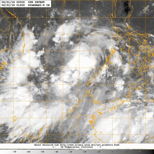
IMAGERY AT 010000Z INDICATES THAT A CIRCULATION CENTER IS LOCATED
NEAR 8.9N 115.7E. THE SYSTEM IS MOVING WEST-SOUTHWESTWARD AT 08
KNOTS.
2. REMARKS: THE AREA OF CONVECTION (INVEST 99W) PREVIOUSLY LOCATED
NEAR 9.1N 116.1E, IS NOW LOCATED NEAR 8.9N 115.7E, APPROXIMATELY 210
NM WEST-SOUTHWEST OF PUERTO PRINCESA, PHILIPPINES. ANIMATED
MULTISPECTRAL SATELLITE IMAGERY DEPICTS FLARING DEEP CONVECTION
WRAPPING INTO A CONSOLIDATED LLCC. VWS REMAINS LOW (10-15 KTS) AND
DIVERGENCE ALOFT HAS IMPROVED OVER THE LAST TWELVE HOURS.
SSTS REMAIN WARM (29-30C) IN THE SOUTH CHINA SEA AND WILL SUPPORT
FURTHER DEVELOPMENT. GLOBAL MODELS PREDICT 99W WILL ASSUME A
GENERALLY NORTHWESTWARD TRACK AND NOW DEVELOPING WITHIN 24 HOURS,
WITH THE UKMO AND JGSM DISSENTING AND NOT DEVELOPING THE SYSTEM.
MAXIMUM SUSTAINED SURFACE WINDS ARE ESTIMATED AT 15 TO 20 KNOTS.
MINIMUM SEA LEVEL PRESSURE IS ESTIMATED TO BE NEAR 1004 MB. THE
POTENTIAL FOR THE DEVELOPMENT OF A SIGNIFICANT TROPICAL CYCLONE
WITHIN THE NEXT 24 HOURS IS HIGH.
3. THIS ALERT WILL BE REISSUED, UPGRADED TO WARNING OR CANCELLED BY
020230Z.//
NNNN
Image
0 likes   
The answer my friend, is blowing in the wind...

User avatar
euro6208
Category 5
Category 5
Posts: 18547
Joined: Mon Mar 08, 2004 7:50 pm
Location: Guam

Re: WPAC: INVEST 99W

#16 Postby euro6208 » Thu May 31, 2018 11:26 pm

TPPN10 PGTW 010313

A. TROPICAL DISTURBANCE 99W (W OF PALAWAN)

B. 01/0250Z

C. 8.79N

D. 115.18E

E. FIVE/HMWRI8

F. N/A

G. IR/EIR/VIS/MSI

H. REMARKS: 49A/PBO PTLY XPSD LLCC/ANMTN.

I. ADDITIONAL POSITIONS: NONE


DAVIS
0 likes   
Remember, all of my post aren't official. For official warnings and discussions, Please refer to your local NWS products...

NWS for the Western Pacific

https://www.weather.gov/gum/

Sciencerocks
Category 5
Category 5
Posts: 7282
Age: 38
Joined: Thu Jul 06, 2017 1:51 am

Re: WPAC: INVEST 99W

#17 Postby Sciencerocks » Fri Jun 01, 2018 12:49 am

Image
0 likes   

User avatar
euro6208
Category 5
Category 5
Posts: 18547
Joined: Mon Mar 08, 2004 7:50 pm
Location: Guam

Re: WPAC: INVEST 99W

#18 Postby euro6208 » Fri Jun 01, 2018 6:55 am

Well well...EURO backs off from any significant intensification. Peak of only 1000 mb. More of a rain event for Hainan Island.
0 likes   
Remember, all of my post aren't official. For official warnings and discussions, Please refer to your local NWS products...

NWS for the Western Pacific

https://www.weather.gov/gum/

User avatar
euro6208
Category 5
Category 5
Posts: 18547
Joined: Mon Mar 08, 2004 7:50 pm
Location: Guam

Re: WPAC: INVEST 99W

#19 Postby euro6208 » Fri Jun 01, 2018 7:06 am

Image
0 likes   
Remember, all of my post aren't official. For official warnings and discussions, Please refer to your local NWS products...

NWS for the Western Pacific

https://www.weather.gov/gum/

User avatar
cycloneye
Admin
Admin
Posts: 139019
Age: 67
Joined: Thu Oct 10, 2002 10:54 am
Location: San Juan, Puerto Rico

Re: WPAC: INVEST 99W

#20 Postby cycloneye » Fri Jun 01, 2018 3:05 pm

Location: 11.1°N 114.3°E
Maximum Winds: 20 kt
Minimum Central Pressure: 1005 mb

Image

Image
0 likes   
Visit the Caribbean-Central America Weather Thread where you can find at first post web cams,radars
and observations from Caribbean basin members Click Here


Return to “2018”

Who is online

Users browsing this forum: No registered users and 26 guests