EPAC: BUD - Post-Tropical
Moderator: S2k Moderators
Re: EPAC: INVEST 92E
I was expecting cooler waters with Aletta passing, but as others pointed out it's still plenty warm.

0 likes
-
Yellow Evan

- Professional-Met

- Posts: 15951
- Age: 25
- Joined: Fri Jul 15, 2011 12:48 pm
- Location: Henderson, Nevada/Honolulu, HI
- Contact:
Re: EPAC: INVEST 92E
0 likes
-
cycloneye

- Admin

- Posts: 139025
- Age: 67
- Joined: Thu Oct 10, 2002 10:54 am
- Location: San Juan, Puerto Rico
Re: EPAC: INVEST 92E
5 PM PDT TWO:
Cloudiness and showers associated with a low pressure system
located about 400 miles south-southeast of Acapulco, Mexico, are
gradually increasing in organization, and the low's circulation is
becoming better defined. Environmental conditions are conducive for
further development, and a tropical depression or tropical storm is
expected to form by late Saturday or Sunday while the system moves
west-northwestward at about 10 mph parallel to the coast of southern
Mexico. For more information on this system, see High Seas
Forecasts issued by the National Weather Service.
* Formation chance through 48 hours...high...90 percent.
* Formation chance through 5 days...high...90 percent.
0 likes
Visit the Caribbean-Central America Weather Thread where you can find at first post web cams,radars
and observations from Caribbean basin members Click Here
and observations from Caribbean basin members Click Here
-
cycloneye
- Admin
- Posts: 139025
- Age: 67
- Joined: Thu Oct 10, 2002 10:54 am
- Location: San Juan, Puerto Rico
Re: EPAC: INVEST 92E
00z Best Track:
EP, 92, 2018060900, , BEST, 0, 117N, 975W, 30, 1007, DB
EP, 92, 2018060900, , BEST, 0, 117N, 975W, 30, 1007, DB
0 likes
Visit the Caribbean-Central America Weather Thread where you can find at first post web cams,radars
and observations from Caribbean basin members Click Here
and observations from Caribbean basin members Click Here
-
Yellow Evan
- Professional-Met
- Posts: 15951
- Age: 25
- Joined: Fri Jul 15, 2011 12:48 pm
- Location: Henderson, Nevada/Honolulu, HI
- Contact:
Re: EPAC: INVEST 92E
* EAST PACIFIC SHIPS INTENSITY FORECAST *
* IR SAT DATA PROXY USED, OHC AVAILABLE *
* INVEST EP922018 06/09/18 00 UTC *
TIME (HR) 0 6 12 18 24 36 48 60 72 84 96 108 120
V (KT) NO LAND 30 32 35 41 47 61 71 79 90 92 92 86 79
V (KT) LAND 30 32 35 41 47 61 71 79 90 92 92 86 79
V (KT) LGEM 30 31 33 35 37 45 55 64 73 79 82 75 65
Storm Type TROP TROP TROP TROP TROP TROP TROP TROP TROP TROP TROP TROP TROP
SHEAR (KT) 11 8 7 10 14 15 11 1 7 10 8 8 7
SHEAR ADJ (KT) 2 4 5 5 7 4 7 1 0 -1 1 0 0
SHEAR DIR 316 331 18 34 23 2 343 298 111 71 50 70 58
SST (C) 30.9 31.0 31.1 31.1 31.0 30.5 29.6 28.7 28.2 27.7 26.2 24.7 25.0
POT. INT. (KT) 171 171 171 171 171 171 161 152 145 139 125 110 111
200 MB T (C) -52.0 -52.5 -52.7 -52.1 -51.7 -52.6 -51.4 -52.0 -51.1 -51.9 -50.6 -50.9 -50.3
200 MB VXT (C) 0.1 0.0 0.0 0.1 0.1 0.1 0.0 0.3 0.7 1.0 0.7 0.7 0.8
TH_E DEV (C) 6 6 5 6 6 7 7 6 6 5 4 2 3
700-500 MB RH 84 87 88 86 86 85 83 81 77 76 72 64 55
MODEL VTX (KT) 10 12 14 15 17 21 22 22 27 27 29 28 26
850 MB ENV VOR 8 1 -4 -4 8 3 19 4 20 23 52 52 53
200 MB DIV 110 95 117 155 150 99 100 126 138 113 97 19 22
700-850 TADV 0 -2 -2 -8 -11 -8 -10 -10 -5 -1 -3 -4 -7
LAND (KM) 461 458 452 463 454 414 370 442 536 557 488 446 530
LAT (DEG N) 11.7 11.9 12.2 12.5 12.9 14.0 15.2 15.8 16.0 16.4 18.0 19.1 19.1
LONG(DEG W) 97.5 98.5 99.5 100.5 101.2 102.8 104.7 106.9 108.6 109.2 109.6 111.4 113.1
STM SPEED (KT) 10 10 10 9 9 10 10 10 6 5 10 10 6
HEAT CONTENT 24 29 38 41 42 62 23 14 9 6 3 0 0
FORECAST TRACK FROM TABM INITIAL HEADING/SPEED (DEG/KT):280/ 9 CX,CY: -8/ 2
T-12 MAX WIND: 30 PRESSURE OF STEERING LEVEL (MB): 686 (MEAN=550)
GOES IR BRIGHTNESS TEMP. STD DEV. 50-200 KM RAD: 16.5 (MEAN=14.5)
% GOES IR PIXELS WITH T < -20 C 50-200 KM RAD: 88.0 (MEAN=65.0)
PRELIM RI PROB (DV .GE. 55 KT IN 48 HR): 48.4
INDIVIDUAL CONTRIBUTIONS TO INTENSITY CHANGE
6 12 18 24 36 48 60 72 84 96 108 120
----------------------------------------------------------
SAMPLE MEAN CHANGE 0. 0. 1. 1. 1. 1. 1. 1. -0. -1. -1. -2.
SST POTENTIAL -1. -2. -2. -1. 5. 13. 21. 27. 29. 30. 30. 29.
VERTICAL SHEAR MAG 1. 2. 2. 2. 2. 2. 2. 3. 2. 2. 3. 4.
VERTICAL SHEAR ADJ -0. -0. -1. -1. -2. -2. -2. -1. -1. -0. -0. -0.
VERTICAL SHEAR DIR -0. -0. 0. 0. 1. 1. 0. 0. 2. 2. 2. 1.
PERSISTENCE -0. -0. -0. -1. -1. -1. -1. -0. -0. -0. 0. 1.
200/250 MB TEMP. -0. -0. -1. -1. -3. -4. -5. -6. -7. -6. -6. -6.
THETA_E EXCESS -0. -0. -0. -0. -0. -0. -0. -0. -0. -1. -2. -3.
700-500 MB RH 0. 0. 1. 1. 1. 2. 3. 4. 5. 6. 6. 7.
MODEL VTX TENDENCY 0. 2. 4. 7. 13. 15. 16. 21. 21. 22. 20. 16.
850 MB ENV VORTICITY 0. 0. 0. 0. 0. 0. 0. 1. 1. 1. 0. 0.
200 MB DIVERGENCE 0. 1. 2. 4. 6. 7. 7. 8. 8. 7. 6. 4.
850-700 T ADVEC -0. -0. 0. 0. -0. -0. -1. -1. -1. -2. -2. -3.
ZONAL STORM MOTION 0. 0. 0. 0. 1. 1. 1. 0. 0. 0. 0. 0.
STEERING LEVEL PRES 0. 1. 1. 2. 2. 3. 3. 3. 3. 3. 3. 3.
DAYS FROM CLIM. PEAK -0. -0. -0. -0. 0. -0. -0. -1. -1. -2. -2. -2.
GOES PREDICTORS 1. 2. 2. 3. 3. 3. 2. 1. 1. 0. 0. 0.
OCEAN HEAT CONTENT 0. 0. 1. 1. 2. 3. 2. 1. 1. 0. 0. -0.
----------------------------------------------------------
TOTAL CHANGE 2. 5. 11. 17. 31. 41. 49. 60. 62. 62. 56. 49.
CURRENT MAX WIND (KT): 30. LAT, LON: 11.7 97.5
** 2017 E.PACIFIC RI INDEX EP922018 INVEST 06/09/18 00 UTC **
(SHIPS-RII PREDICTOR TABLE for 30 KT OR MORE MAXIMUM WIND INCREASE IN NEXT 24-h)
Predictor Value RI Predictor Range Scaled Value(0-1) % Contribution
12 HR PERSISTENCE (KT): 0.0 -22.0 to 44.0 0.33 999.0
POT = MPI-VMAX (KT) : 141.2 40.5 to 149.3 0.93 999.0
850-200 MB SHEAR (KT) : 10.2 18.9 to 1.4 0.50 999.0
HEAT CONTENT (KJ/cm2) : 34.8 0.0 to 106.7 0.33 999.0
MAXIMUM WIND (kt) : 30.0 22.5 to 132.0 0.21 999.0
D200 (10**7s-1) : 125.4 -33.0 to 156.2 0.84 999.0
STD DEV OF IR BR TEMP : 999.0 37.8 to 2.1 999.00 999.0
% AREA WITH TPW <45 mm: 0.0 62.3 to 0.0 1.00 999.0
2nd PC OF IR BR TEMP : 9999.0 2.2 to -1.9 999.00 999.0
BL DRY-AIR FLUX (w/m2): -35.6 735.9 to -82.5 0.94 999.0
SHIPS Prob RI for 20kt/ 12hr RI threshold= 999% is 999.0 times sample mean ( 7.7%)
SHIPS Prob RI for 25kt/ 24hr RI threshold= 999% is 999.0 times sample mean (15.3%)
SHIPS Prob RI for 30kt/ 24hr RI threshold= 999% is 999.0 times sample mean (10.4%)
SHIPS Prob RI for 35kt/ 24hr RI threshold= 999% is 999.0 times sample mean ( 7.5%)
SHIPS Prob RI for 40kt/ 24hr RI threshold= 999% is 999.0 times sample mean ( 5.2%)
SHIPS Prob RI for 45kt/ 36hr RI threshold= 999% is 999.0 times sample mean ( 8.1%)
SHIPS Prob RI for 55kt/ 48hr RI threshold= 999% is 999.0 times sample mean ( 7.4%)
SHIPS Prob RI for 65kt/ 72hr RI threshold= 999% is 999.0 times sample mean ( 5.5%)
Matrix of RI probabilities
------------------------------------------------------------------------------
RI (kt / h) | 20/12 | 25/24 | 30/24 | 35/24 | 40/24 | 45/36 | 55/48 |65/72
------------------------------------------------------------------------------
SHIPS-RII: 999.0% 999.0% 999.0% 999.0% 999.0% 999.0% 999.0% 999.0%
Logistic: 999.0% 999.0% 999.0% 999.0% 999.0% 999.0% 999.0% 999.0%
Bayesian: 999.0% 999.0% 999.0% 999.0% 999.0% 999.0% 999.0% 999.0%
Consensus: 999.0% 999.0% 999.0% 999.0% 999.0% 999.0% 999.0% 999.0%
## ANNULAR HURRICANE INDEX (AHI) EP922018 INVEST 06/09/18 00 UTC ##
## STORM NOT ANNULAR, SCREENING STEP FAILED, NPASS=3 NFAIL=4 ##
## AHI= 0 (AHI OF 100 IS BEST FIT TO ANN. STRUC., 1 IS MARGINAL, 0 IS NOT ANNULAR) ##
1 likes
-
gatorcane

- S2K Supporter

- Posts: 23499
- Age: 46
- Joined: Sun Mar 13, 2005 3:54 pm
- Location: Boca Raton, FL
Re: EPAC: INVEST 92E
Yellow Evan wrote::uarrow: I think the storm track lay in the GFS model storm's outflow at 12z hence why it wasn't bullish on first run.
Yeah good point looks stronger on 18Z.
0 likes
-
cycloneye
- Admin
- Posts: 139025
- Age: 67
- Joined: Thu Oct 10, 2002 10:54 am
- Location: San Juan, Puerto Rico
Re: EPAC: INVEST 92E
gatorcane wrote:Yellow Evan wrote::uarrow: I think the storm track lay in the GFS model storm's outflow at 12z hence why it wasn't bullish on first run.
Yeah good point looks stronger on 18Z.
And SHIP intensity is also stronger than the past run as it goes up to almost cat 3 in this 00z run.

0 likes
Visit the Caribbean-Central America Weather Thread where you can find at first post web cams,radars
and observations from Caribbean basin members Click Here
and observations from Caribbean basin members Click Here
-
cycloneye
- Admin
- Posts: 139025
- Age: 67
- Joined: Thu Oct 10, 2002 10:54 am
- Location: San Juan, Puerto Rico
Re: EPAC: INVEST 92E
CrazyC83 wrote:Looks like Bud will be another strong one too...
Good chance will be the second major of season.
0 likes
Visit the Caribbean-Central America Weather Thread where you can find at first post web cams,radars
and observations from Caribbean basin members Click Here
and observations from Caribbean basin members Click Here
-
hurricanes1234
- Category 5

- Posts: 2903
- Joined: Sat Jul 28, 2012 6:19 pm
- Location: Trinidad and Tobago
Re: EPAC: INVEST 92E
100%/100%
1. Showers and thunderstorms associated with a low pressure area centered about 400 miles south of Acapulco, Mexico, have become more concentrated since yesterday, and the low's circulation is becoming better defined. Environmental conditions are conducive for further development, and a tropical depression or tropical storm is expected to form by late Saturday while the system moves west-northwestward at about 10 mph parallel to but offshore of the coast of southern Mexico. For more information on this system, see High Seas Forecasts issued by the National Weather Service. * Formation chance through 48 hours...high...near 100 percent. * Formation chance through 5 days...high...near 100 percent.
2 likes
PLEASE NOTE: With the exception of information from weather agencies that I may copy and paste here, my posts will NEVER be official, since I am NOT a meteorologist. They are solely my amateur opinion, and may or may not be accurate. Therefore, please DO NOT use them as official details, particularly when making important decisions. Thank you.
-
cycloneye
- Admin
- Posts: 139025
- Age: 67
- Joined: Thu Oct 10, 2002 10:54 am
- Location: San Juan, Puerto Rico
Re: EPAC: INVEST 92E
Showers and thunderstorms associated with a low pressure area
centered about 400 miles south of Acapulco, Mexico, are becoming
better organized. If current trends continue, advisories could be
initiated later today while the system moves west-northwestward
at about 10 mph, parallel to, but offshore of the coast of southern
Mexico. For more information on this system, see High Seas
Forecasts issued by the National Weather Service.
* Formation chance through 48 hours...high...near 100 percent.
* Formation chance through 5 days...high...near 100 percent.
0 likes
Visit the Caribbean-Central America Weather Thread where you can find at first post web cams,radars
and observations from Caribbean basin members Click Here
and observations from Caribbean basin members Click Here
-
cycloneye
- Admin
- Posts: 139025
- Age: 67
- Joined: Thu Oct 10, 2002 10:54 am
- Location: San Juan, Puerto Rico
Re: EPAC: INVEST 92E
12z Best Track:
EP, 92, 2018060912, , BEST, 0, 117N, 1007W, 30, 1007, LO
EP, 92, 2018060912, , BEST, 0, 117N, 1007W, 30, 1007, LO
0 likes
Visit the Caribbean-Central America Weather Thread where you can find at first post web cams,radars
and observations from Caribbean basin members Click Here
and observations from Caribbean basin members Click Here
-
cycloneye
- Admin
- Posts: 139025
- Age: 67
- Joined: Thu Oct 10, 2002 10:54 am
- Location: San Juan, Puerto Rico
Re: EPAC: INVEST 92E
Code: Select all
                  * EAST PACIFIC SHIPS INTENSITY FORECAST          *
                    * IR SAT DATA PROXY USED,      OHC AVAILABLE     *
                    *  INVEST      EP922018  06/09/18  12 UTC        *

TIME (HR)          0     6    12    18    24    36    48    60    72    84    96   108   120
V (KT) NO LAND    30    34    38    44    50    60    69    76    83    85    81    75    67
V (KT) LAND       30    34    38    44    50    60    69    76    83    85    81    75    67
V (KT) LGEM       30    33    36    39    41    47    52    58    63    67    66    60    53
Storm Type      TROP  TROP  TROP  TROP  TROP  TROP  TROP  TROP  TROP  TROP  TROP  TROP  TROP

SHEAR (KT)        15    17    17    22    18    16     7     7    10    13     8    12    11
SHEAR ADJ (KT)     1     0     7     4     5     3     6     1    -1     3     0     0     0
SHEAR DIR         40    48    21    28    23     7   353   100    90    58    39    52    52
SST (C)         30.9  30.9  30.8  30.7  30.6  30.3  29.2  27.8  27.6  27.9  26.3  24.5  24.8
POT. INT. (KT)   171   170   169   169   170   168   159   143   137   142   127   107   107
200 MB T (C)   -53.1 -52.6 -52.0 -52.7 -52.8 -51.8 -52.1 -51.0 -51.8 -51.0 -51.5 -50.3 -51.3
200 MB VXT (C)   0.0   0.1   0.1   0.1   0.1   0.1   0.2   0.6   0.7   0.6   0.4   0.4   0.5
TH_E DEV (C)       5     6     6     6     6     7     6     6     5     5     4     3     3
700-500 MB RH     89    87    87    87    86    84    85    77    73    74    73    63    62
MODEL VTX (KT)    14    16    19    20    21    22    24    24    27    30    29    28    27
850 MB ENV VOR   -23   -24   -23   -35   -37     3     5    17    29    30    44    55    30
200 MB DIV       109   107   174   190   149    93   113   115   112   143    62    32    18
700-850 TADV      -6   -10   -14   -17   -12    -8   -14    -5    -1     0    -1    -4    -4
LAND (KM)        553   583   595   587   559   447   343   454   620   562   423   415   464
LAT (DEG N)     11.7  11.8  11.9  12.2  12.6  14.0  15.9  16.8  16.2  16.2  18.2  19.3  19.0
LONG(DEG W)    100.7 101.6 102.1 102.6 102.9 103.4 105.4 108.3 109.8 109.1 109.0 111.1 111.6
STM SPEED (KT)     9     7     5     5     6    10    15    11     4     7    11     9     2
HEAT CONTENT      36    39    43    50    58    58    15     7     6     5     2     0     0

  FORECAST TRACK FROM TABM      INITIAL HEADING/SPEED (DEG/KT):275/ 10      CX,CY:  -9/  1
  T-12 MAX WIND:  25            PRESSURE OF STEERING LEVEL (MB):  504  (MEAN=550)
  GOES IR BRIGHTNESS TEMP. STD DEV.  50-200 KM RAD:  16.8 (MEAN=14.5)
  % GOES IR PIXELS WITH T < -20 C    50-200 KM RAD:  87.0 (MEAN=65.0)
  PRELIM RI PROB (DV .GE. 55 KT IN 48 HR):           35.0

                        INDIVIDUAL CONTRIBUTIONS TO INTENSITY CHANGE
                         6   12   18   24   36   48   60   72   84   96  108  120
                        ----------------------------------------------------------
  SAMPLE MEAN CHANGE     0.   0.   1.   1.   1.   1.   1.   1.  -0.  -1.  -1.  -2.
  SST POTENTIAL         -1.  -1.  -1.  -0.   5.  13.  21.  26.  29.  29.  29.  28.
  VERTICAL SHEAR MAG     0.   1.   0.  -1.  -2.  -3.  -3.  -3.  -4.  -4.  -3.  -2.
  VERTICAL SHEAR ADJ    -0.  -0.  -1.  -1.  -1.  -2.  -1.  -1.  -0.  -0.  -0.  -0.
  VERTICAL SHEAR DIR     1.   1.   2.   3.   4.   4.   5.   5.   6.   6.   6.   5.
  PERSISTENCE            1.   2.   2.   2.   2.   2.   2.   1.   1.   1.   1.   0.
  200/250 MB TEMP.       0.  -0.  -1.  -1.  -2.  -4.  -5.  -5.  -6.  -6.  -6.  -6.
  THETA_E EXCESS        -0.  -0.  -0.  -0.  -0.  -0.  -0.  -0.  -1.  -1.  -3.  -4.
  700-500 MB RH          0.   0.   1.   1.   1.   2.   3.   4.   5.   5.   6.   7.
  MODEL VTX TENDENCY     1.   3.   5.   8.  10.  13.  14.  18.  20.  18.  16.  13.
  850 MB ENV VORTICITY   0.   0.   0.   0.   0.   1.   1.   1.   1.   1.   1.   1.
  200 MB DIVERGENCE      0.   2.   3.   5.   6.   7.   8.   8.   8.   7.   5.   4.
  850-700 T ADVEC       -0.  -0.   0.   0.  -0.  -0.  -1.  -2.  -2.  -2.  -3.  -4.
  ZONAL STORM MOTION     0.   0.   1.   1.   1.   1.   1.   1.   1.   1.   0.   1.
  STEERING LEVEL PRES   -0.  -0.  -1.  -1.  -1.  -1.  -1.  -2.  -2.  -2.  -2.  -2.
  DAYS FROM CLIM. PEAK  -0.  -0.  -0.  -0.   0.  -0.  -0.  -1.  -1.  -2.  -2.  -2.
  GOES PREDICTORS        1.   2.   2.   3.   3.   2.   2.   1.   1.   0.   0.   0.
  OCEAN HEAT CONTENT     0.   1.   1.   2.   3.   3.   2.   1.   1.   0.   0.  -0.
                        ----------------------------------------------------------
  TOTAL CHANGE           4.   8.  14.  20.  30.  39.  46.  53.  55.  51.  45.  37.

                CURRENT MAX WIND (KT):   30. LAT, LON:   11.7   100.7

      ** 2017 E.PACIFIC RI INDEX EP922018 INVEST     06/09/18  12 UTC **
 (SHIPS-RII PREDICTOR TABLE for 30 KT OR MORE MAXIMUM WIND INCREASE IN NEXT 24-h)

     Predictor             Value   RI Predictor Range  Scaled Value(0-1) % Contribution
 12 HR PERSISTENCE (KT):     5.0     -22.0  to   44.0       0.41         999.0
 POT = MPI-VMAX (KT)   :   139.9      40.5  to  149.3       0.91         999.0
 850-200 MB SHEAR (KT) :    17.9      18.9  to    1.4       0.06         999.0
 HEAT CONTENT (KJ/cm2) :    45.2       0.0  to  106.7       0.42         999.0
 MAXIMUM WIND (kt)     :    30.0      22.5  to  132.0       0.21         999.0
 D200 (10**7s-1)       :   145.8     -33.0  to  156.2       0.95         999.0
 STD DEV OF IR BR TEMP :   999.0      37.8  to    2.1     999.00         999.0
 % AREA WITH TPW <45 mm:     0.0      62.3  to    0.0       1.00         999.0
 2nd PC OF IR BR TEMP  :     1.0       2.2  to   -1.9       0.29         999.0
 BL DRY-AIR FLUX (w/m2):   -25.0     735.9  to  -82.5       0.93         999.0

 SHIPS Prob RI for 20kt/ 12hr RI threshold= 999% is 999.0 times sample mean ( 7.7%)
 SHIPS Prob RI for 25kt/ 24hr RI threshold= 999% is 999.0 times sample mean (15.3%)
 SHIPS Prob RI for 30kt/ 24hr RI threshold= 999% is 999.0 times sample mean (10.4%)
 SHIPS Prob RI for 35kt/ 24hr RI threshold= 999% is 999.0 times sample mean ( 7.5%)
 SHIPS Prob RI for 40kt/ 24hr RI threshold= 999% is 999.0 times sample mean ( 5.2%)
 SHIPS Prob RI for 45kt/ 36hr RI threshold= 999% is 999.0 times sample mean ( 8.1%)
 SHIPS Prob RI for 55kt/ 48hr RI threshold= 999% is 999.0 times sample mean ( 7.4%)
 SHIPS Prob RI for 65kt/ 72hr RI threshold= 999% is 999.0 times sample mean ( 5.5%)

Matrix of RI probabilities
------------------------------------------------------------------------------
  RI (kt / h)  | 20/12 | 25/24 | 30/24 | 35/24 | 40/24 | 45/36 | 55/48  |65/72
------------------------------------------------------------------------------
   SHIPS-RII:   999.0%  999.0%  999.0%  999.0%  999.0%  999.0%  999.0%  999.0%
    Logistic:   999.0%  999.0%  999.0%  999.0%  999.0%  999.0%  999.0%  999.0%
    Bayesian:   999.0%  999.0%  999.0%  999.0%  999.0%  999.0%  999.0%  999.0%
   Consensus:   999.0%  999.0%  999.0%  999.0%  999.0%  999.0%  999.0%  999.0%

   ##         ANNULAR HURRICANE INDEX (AHI) EP922018 INVEST     06/09/18  12 UTC         ##
0 likes
Visit the Caribbean-Central America Weather Thread where you can find at first post web cams,radars
and observations from Caribbean basin members Click Here
and observations from Caribbean basin members Click Here
-
Yellow Evan
- Professional-Met
- Posts: 15951
- Age: 25
- Joined: Fri Jul 15, 2011 12:48 pm
- Location: Henderson, Nevada/Honolulu, HI
- Contact:
-
zeehag
- Tropical Storm

- Posts: 172
- Age: 75
- Joined: Sun Jul 17, 2011 9:49 pm
- Location: mazatlan,sinaloa, mexico, fixing patricia's mess.
- Contact:
Re: EPAC: INVEST 92E
here in mazatlan we are growing nervous as the possibility of this bud's for us grows.
(reminder to self.. ditch magnet in pocket..run like hell.)
we are busily prepping here in mazatlan for the possibilities of target practice by nature. is not a fun position, as i learned before with patricia. we who reside here in mazatlan would be most grateful to see this go to open ocean.
we are watching closely.
1 likes
-
Shell Mound
- Category 5
- Posts: 2434
- Age: 31
- Joined: Thu Sep 07, 2017 3:39 pm
- Location: St. Petersburg, FL → Scandinavia
Re: EPAC: INVEST 92E
https://twitter.com/iCyclone/status/1004831123866652672
https://twitter.com/Meteoalert_TAM/status/1005189055460474880
https://twitter.com/iCyclone/status/1005197577136963584
https://twitter.com/Meteoalert_TAM/status/1005192309552472064
https://twitter.com/Meteoalert_TAM/status/1005189055460474880
https://twitter.com/iCyclone/status/1005197577136963584
https://twitter.com/Meteoalert_TAM/status/1005192309552472064
1 likes
CVW / MiamiensisWx / Shell Mound
The posts in this forum are NOT official forecasts and should not be used as such. They are just the opinion of the poster and may or may not be backed by sound meteorological data. They are NOT endorsed by any professional institution or STORM2K. For official information, please refer to products from the NHC and NWS.
-
cycloneye
- Admin
- Posts: 139025
- Age: 67
- Joined: Thu Oct 10, 2002 10:54 am
- Location: San Juan, Puerto Rico
Re: EPAC: INVEST 92E
Satellite imagery indicates that showers and thunderstorms
associated with a low pressure area centered about 350 miles south
of Acapulco, Mexico, continue to become better organized. If
current trends continue, advisories will likely be initiated later
this afternoon while the system moves west-northwestward at about
10 mph, parallel to, but offshore of the coast of southern Mexico.
For more information on this system, see High Seas Forecasts issued
by the National Weather Service.
* Formation chance through 48 hours...high...near 100 percent.
* Formation chance through 5 days...high...near 100 percent.
1 likes
Visit the Caribbean-Central America Weather Thread where you can find at first post web cams,radars
and observations from Caribbean basin members Click Here
and observations from Caribbean basin members Click Here

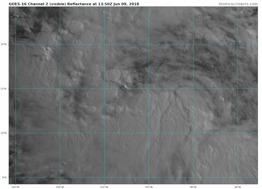
Re: EPAC: INVEST 92E: 11 AM PDT TWO= Advisories will begin this afternoon on TD 3-E or on TS Bud
Visible. At the very least worthy of TD
2 likes
The above post and any post by Ntxw is NOT an official forecast and should not be used as such. It is just the opinion of the poster and may or may not be backed by sound meteorological data. It is NOT endorsed by any professional institution including Storm2k. For official information, please refer to NWS products.
Help support Storm2K!

-
storminabox
- Category 1

- Posts: 260
- Joined: Sun Jul 09, 2017 10:50 pm
Re: EPAC: INVEST 92E: 11 AM PDT TWO= Advisories will begin this afternoon on TD 3-E or on TS Bud
Ntxw wrote:Visible. At the very least worthy of TD
Yeah this thing should be classified.
1 likes
Who is online
Users browsing this forum: No registered users and 47 guests