14/1745 UTC 15.3N 100.0W T1.0/1.0 93E -- East Pacific
EPAC: CARLOTTA - Post-Tropical
Moderator: S2k Moderators
-
Yellow Evan

- Professional-Met

- Posts: 15951
- Age: 25
- Joined: Fri Jul 15, 2011 12:48 pm
- Location: Henderson, Nevada/Honolulu, HI
- Contact:
-
Kingarabian

- S2K Supporter

- Posts: 15432
- Joined: Sat Aug 08, 2009 3:06 am
- Location: Honolulu, Hawaii
Re: EPAC: FOUR-E - Tropical Depression
Since it has about 60 hours before landfall, let's see if it keeps the hurricane streak going or not. Hope residents near SW Mexico are prepared for the potential of flooding and mudslides since it looks to be a slow mover.
3 likes
RIP Kobe Bryant
-
CyclonicFury

- Category 5

- Posts: 1970
- Age: 25
- Joined: Sun Jul 02, 2017 12:32 pm
- Location: NC
- Contact:
Re: EPAC: FOUR-E - Tropical Depression
When was the last time the EPAC had its fourth TC of a season this early?
3 likes
NCSU B.S. in Meteorology Class of 2021. Tropical weather blogger at http://www.cyclonicfury.com. My forecasts and thoughts are NOT official, for official forecasts please consult the National Hurricane Center.
-
StruThiO

- Category 3

- Posts: 821
- Age: 24
- Joined: Fri Sep 15, 2017 5:51 am
- Location: Currently Portland, OR. Raised in Jax, FL.
Re: EPAC: FOUR-E - Tropical Depression
It has been an active early part of the eastern Pacific season.
This is the 2nd earliest 4th tropical cyclone on record in the
basin during the satellite era (1966-present), only 6 hours behind
the previous record in 1974.
3 likes
-
cycloneye

- Admin

- Posts: 139011
- Age: 67
- Joined: Thu Oct 10, 2002 10:54 am
- Location: San Juan, Puerto Rico
Re: EPAC: FOUR-E - Tropical Depression
BULLETIN
Tropical Depression Four-E Intermediate Advisory Number 1A
NWS National Hurricane Center Miami FL EP042018
700 PM CDT Thu Jun 14 2018
...TROPICAL DEPRESSION BRINGING HEAVY RAINS TO THE SOUTHWEST COAST
OF MEXICO...
SUMMARY OF 700 PM CDT...0000 UTC...INFORMATION
----------------------------------------------
LOCATION...15.6N 100.2W
ABOUT 90 MI...150 KM SSW OF ACAPULCO MEXICO
ABOUT 170 MI...275 KM SSE OF ZIHUATANEJO MEXICO
MAXIMUM SUSTAINED WINDS...35 MPH...55 KM/H
PRESENT MOVEMENT...NW OR 325 DEGREES AT 5 MPH...8 KM/H
MINIMUM CENTRAL PRESSURE...1008 MB...29.77 INCHES
WATCHES AND WARNINGS
--------------------
CHANGES WITH THIS ADVISORY:
None.
SUMMARY OF WATCHES AND WARNINGS IN EFFECT:
A Tropical Storm Watch is in effect for...
* Tecpan de Galeana to Punta Maldonado.
A Tropical Storm Watch means that tropical storm conditions are
possible within the watch area, generally within 48 hours.
For storm information specific to your area, please monitor
products issued by your national meteorological service.
DISCUSSION AND OUTLOOK
----------------------
At 700 PM CDT (0000 UTC), the center of Tropical Depression Four-E
was located near latitude 15.6 North, longitude 100.2 West. The
depression is moving toward the northwest near 5 mph (8 km/h), and
this motion is expected to continue overnight. The cyclone is
forecast to slow down as it approaches the coast of southern Mexico
on Friday and Saturday, and could move inland on Sunday.
Maximum sustained winds are near 35 mph (55 km/h) with higher
gusts. Gradual strengthening is forecast during the next 48 hours.
The estimated minimum central pressure is 1008 mb (29.77 inches).
HAZARDS AFFECTING LAND
----------------------
RAINFALL: The depression is forecast to produce 4 to 6 inches of
rainfall along the Guerrero coast, including the city of Acapulco,
with isolated higher amounts approaching 8 inches possible. These
rains could produce life-threatening flash floods and mud slides.
Farther inland across the state of Guerrero, rainfall amounts of 1
to 2 inches with isolated amounts of 4 inches are forecast.
WIND: Tropical storm conditions are possible within the watch
area by Saturday afternoon.
SURF: Swells generated by the depression are affecting portions of
the coast of southern Mexico. These swells are likely to cause
life-threatening surf and rip current conditions. Please consult
products from your local weather office.
NEXT ADVISORY
-------------
Next complete advisory at 1000 PM CDT.
$$
Forecaster Zelinsky
1 likes
Visit the Caribbean-Central America Weather Thread where you can find at first post web cams,radars
and observations from Caribbean basin members Click Here
and observations from Caribbean basin members Click Here
-
cycloneye
- Admin
- Posts: 139011
- Age: 67
- Joined: Thu Oct 10, 2002 10:54 am
- Location: San Juan, Puerto Rico
Re: EPAC: FOUR-E - Tropical Depression
EP, 04, 2018061500, , BEST, 0, 153N, 1002W, 30, 1007, TD

1 likes
Visit the Caribbean-Central America Weather Thread where you can find at first post web cams,radars
and observations from Caribbean basin members Click Here
and observations from Caribbean basin members Click Here
-
cycloneye
- Admin
- Posts: 139011
- Age: 67
- Joined: Thu Oct 10, 2002 10:54 am
- Location: San Juan, Puerto Rico
Re: EPAC: FOUR-E - Tropical Depression
Tropical Depression Four-E Discussion Number 2
NWS National Hurricane Center Miami FL EP042018
1000 PM CDT Thu Jun 14 2018
Tropical Depression Four-E remains very disorganized. Last-light
visible imagery showed that multiple low-level swirls are rotating
around a mean center. IR imagery and radar data from the Mexican
radar in Acapulco indicate that deep convection is largely limited
to a broken band wrapping around the eastern half of the depression,
with only a single burst of deep convection recently observed near
the estimated center. Given the disorganized nature of the
depression, the initial intensity has been held at 30 kt, though it
is possible this is generous.
Little change has been made to the intensity forecast. Although
SSTs exceed 30 deg C along the forecast track, moderate vertical
wind shear, close proximity to land, and the lack of an inner core
should limit the intensification rate. Rapid weakening is likely
following landfall, and the system is now forecast to dissipate
within 96 h. The official forecast remains near the corrected
consensus aid HCCA.
The disorganized nature of the depression makes it difficult to
identify and track a surface center, so the initial position and
motion estimates are very uncertain. All of the global models
indicate that the system will meander near the coast of Mexico for
the next couple of days, ultimately drifting northward toward land.
The NHC forecast is very close to a blend of the GFS, ECMWF, and the
previous track advisory. It is worth noting that confidence in both
the track and intensity forecast is low. It is possible that the
surface center could reform one or more times over the next couple
of days, either bringing the system inland sooner than currently
forecast or keeping it over water longer than expected. Large
changes to the intensity or track forecasts may be required in
future advisories.
FORECAST POSITIONS AND MAX WINDS
INIT 15/0300Z 15.4N 100.3W 30 KT 35 MPH
12H 15/1200Z 15.6N 100.3W 30 KT 35 MPH
24H 16/0000Z 15.8N 100.2W 35 KT 40 MPH
36H 16/1200Z 15.9N 99.9W 45 KT 50 MPH
48H 17/0000Z 16.2N 99.8W 50 KT 60 MPH
72H 18/0000Z 17.0N 100.0W 35 KT 40 MPH...INLAND
96H 19/0000Z...DISSIPATED
$$
Forecaster Zelinsky
1 likes
Visit the Caribbean-Central America Weather Thread where you can find at first post web cams,radars
and observations from Caribbean basin members Click Here
and observations from Caribbean basin members Click Here
-
cycloneye
- Admin
- Posts: 139011
- Age: 67
- Joined: Thu Oct 10, 2002 10:54 am
- Location: San Juan, Puerto Rico
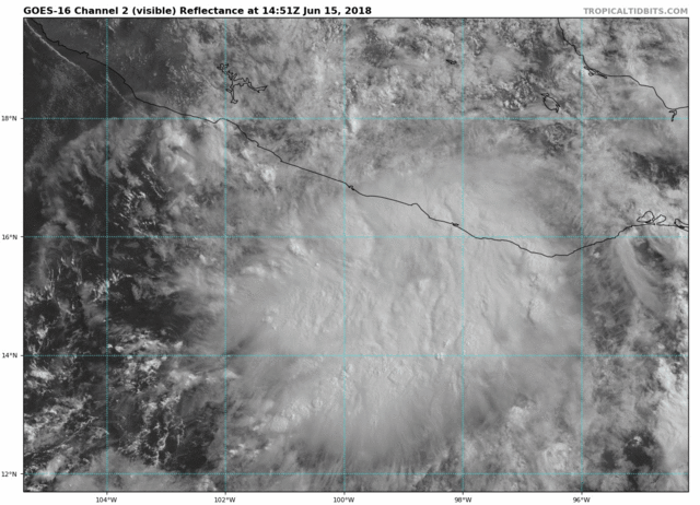
Re: EPAC: FOUR-E - Tropical Depression
Tropical Depression Four-E Discussion Number 3
NWS National Hurricane Center Miami FL EP042018
400 AM CDT Fri Jun 15 2018
The center of the depression has been difficult to locate, although
GOES-16 infrared satellite images and radar data from Acapulco
suggest that the system as a whole has not moved very much. Deep
convection has increased over the past few hours, but it bears
little association with the estimated center and is focused
primarily where low-level convergence is maximized near the coast.
Although some strengthening is possible over the next couple of
days, moderate northerly shear and the cyclone's proximity to land
will likely limit the amount of intensification that can occur.
The SHIPS guidance only shows modest strengthening, and the global
models don't really deepen the low much, if any, before it moves
inland. The updated NHC intensity forecast is close to the SHIPS
and HCCA models and is a little lower than the previous forecast at
48 h. A 72-hour point is provided inland for continuity, but the
cyclone could dissipate before that time.
The depression is currently stationary in a region absent of
steering currents. However, as a low- to mid-level trough moves
northwestward over the Gulf of Mexico toward Texas in the coming
days, that feature should cause the depression to drift
northeastward and then northward, moving inland over southern Mexico
between 48-72 hours. The new NHC forecast is slightly east of the
previous one, following the preponderance of the available guidance.
As noted before, there is lower-than-normal confidence in both the
track and intensity forecasts. Changes to the forecast, as well as
modifications to the warned areas, could be required in subsequent
advisories if the location and size of the cyclone become clearer.
FORECAST POSITIONS AND MAX WINDS
INIT 15/0900Z 15.3N 100.2W 30 KT 35 MPH
12H 15/1800Z 15.4N 100.0W 30 KT 35 MPH
24H 16/0600Z 15.5N 99.6W 35 KT 40 MPH
36H 16/1800Z 15.8N 99.2W 40 KT 45 MPH
48H 17/0600Z 16.2N 99.0W 45 KT 50 MPH
72H 18/0600Z 16.9N 99.0W 30 KT 35 MPH...INLAND
96H 19/0600Z...DISSIPATED
$$
Forecaster Berg
0 likes
Visit the Caribbean-Central America Weather Thread where you can find at first post web cams,radars
and observations from Caribbean basin members Click Here
and observations from Caribbean basin members Click Here
-
cycloneye
- Admin
- Posts: 139011
- Age: 67
- Joined: Thu Oct 10, 2002 10:54 am
- Location: San Juan, Puerto Rico
Re: EPAC: FOUR-E - Tropical Depression
Tropical Depression Four-E Discussion Number 4
NWS National Hurricane Center Miami FL EP042018
1000 AM CDT Fri Jun 15 2018
Radar data from Acapulco, plus satellite and microwave imagery,
indicate that the depression has either reformed and/or is moving
slowly toward the north-northeast. Overall, the satellite
presentation has improved over the past several hours, with a large
band of convection in the southeastern quadrant. The initial wind
speed remains 30 kt for this advisory, and perhaps scatterometer
data will give us a better look at the wind field this afternoon.
Since the center has shifted to the north-northeast, the timing of
landfall along the coast of Mexico has accelerated, with the bulk of
the guidance now suggesting a Saturday landfall rather than Sunday.
The official forecast now goes with the faster scenario, close to a
cluster of the GFS ensemble mean and HMON models and the eastern
Pacific track consensus aid TVCE. While the environmental
conditions still appear to be conducive for strengthening, the
depression has less time to intensify because of the faster landfall
timing. Consequently, the intensity forecast is reduced from the
previous one, but is a little higher than the model consensus.
Although this system is expected to have only a low wind threat,
there is a significant risk of life-threatening flash floods and
mudslides over the southern parts of Guerrero and Oaxaca due to
moist southwesterly flow intersecting the southern Sierra Madre
mountains. Please see products issued by your local weather office
for more details.
FORECAST POSITIONS AND MAX WINDS
INIT 15/1500Z 15.8N 99.7W 30 KT 35 MPH
12H 16/0000Z 16.1N 99.4W 35 KT 40 MPH
24H 16/1200Z 16.5N 99.0W 40 KT 45 MPH
36H 17/0000Z 16.8N 98.7W 30 KT 35 MPH...INLAND
48H 17/1200Z 17.2N 98.6W 20 KT 25 MPH...POST-TROP/INLAND
72H 18/1200Z...DISSIPATED
$$
Forecaster Blake
0 likes
Visit the Caribbean-Central America Weather Thread where you can find at first post web cams,radars
and observations from Caribbean basin members Click Here
and observations from Caribbean basin members Click Here
-
cycloneye
- Admin
- Posts: 139011
- Age: 67
- Joined: Thu Oct 10, 2002 10:54 am
- Location: San Juan, Puerto Rico
Re: EPAC: Carlotta - Tropical Storm
Is now TS Carlotta:
BULLETIN
Tropical Storm Carlotta Intermediate Advisory Number 4A
NWS National Hurricane Center Miami FL EP042018
100 PM CDT Fri Jun 15 2018
...CARLOTTA FORMS JUST SOUTH OF MEXICO...
...CONTINUED HEAVY RAIN THE MAIN THREAT...
SUMMARY OF 100 PM CDT...1800 UTC...INFORMATION
----------------------------------------------
LOCATION...16.0N 99.4W
ABOUT 60 MI...95 KM SSE OF ACAPULCO MEXICO
ABOUT 60 MI...95 KM WSW OF PUNTA MALDONADO MEXICO
MAXIMUM SUSTAINED WINDS...40 MPH...65 KM/H
PRESENT MOVEMENT...NE OR 45 DEGREES AT 5 MPH...7 KM/H
MINIMUM CENTRAL PRESSURE...1006 MB...29.71 INCHES
1 likes
Visit the Caribbean-Central America Weather Thread where you can find at first post web cams,radars
and observations from Caribbean basin members Click Here
and observations from Caribbean basin members Click Here

Re: EPAC: Carlotta - Tropical Storm
TS Carlotta visible
4 likes
The above post and any post by Ntxw is NOT an official forecast and should not be used as such. It is just the opinion of the poster and may or may not be backed by sound meteorological data. It is NOT endorsed by any professional institution including Storm2k. For official information, please refer to NWS products.
Help support Storm2K!

-
cycloneye
- Admin
- Posts: 139011
- Age: 67
- Joined: Thu Oct 10, 2002 10:54 am
- Location: San Juan, Puerto Rico
Re: EPAC: CARLOTTA - Tropical Storm
Tropical Storm Carlotta Discussion Number 5
NWS National Hurricane Center Miami FL EP042018
400 PM CDT Fri Jun 15 2018
Satellite images indicate that Carlotta is slowly getting better
organized, with lots of banding features. ASCAT data indicated
peak winds of near 35 kt, close to the coast of Mexico, and this
will be the initial wind speed, matching the latest Dvorak estimates
from TAFB/SAB.
Radar data from Acapulco suggest that Carlotta hasn't moved a lot
in the past few hours, and continues moving slowly to the northeast.
The storm should get steered in that general direction through
landfall early tomorrow due to the influences of a large trough
over the western Gulf of Mexico. Little change was made to the
official track forecast, except the landfall is about 6 hours
sooner. Carlotta doesn't have much time left to intensify, but could
strengthen a little more before the small cyclone quickly dissipates
over Mexico.
Although this system is expected to have only a low wind threat,
there is a significant risk of life-threatening flash floods and
mudslides over the southern parts of Guerrero and Oaxaca due to
moist southwesterly flow intersecting the southern Sierra Madre
mountains. Please see products issued by your local weather office
for more details.
FORECAST POSITIONS AND MAX WINDS
INIT 15/2100Z 16.1N 99.3W 35 KT 40 MPH
12H 16/0600Z 16.4N 99.0W 40 KT 45 MPH
24H 16/1800Z 16.9N 98.8W 30 KT 35 MPH...INLAND
36H 17/0600Z...DISSIPATED
$$
Forecaster Blake
0 likes
Visit the Caribbean-Central America Weather Thread where you can find at first post web cams,radars
and observations from Caribbean basin members Click Here
and observations from Caribbean basin members Click Here
-
cycloneye
- Admin
- Posts: 139011
- Age: 67
- Joined: Thu Oct 10, 2002 10:54 am
- Location: San Juan, Puerto Rico
Re: EPAC: CARLOTTA - Tropical Storm
Tropical Storm Carlotta Discussion Number 6
NWS National Hurricane Center Miami FL EP042018
1000 PM CDT Fri Jun 15 2018
Carlotta remains a compact tropical storm with deep convection
confined to a region of about 75 n mi from the center. Although
the convection is a little stronger than earlier today, the Dvorak
intensity estimates from TAFB and SAB are unchanged at 2.5/35 kt.
Therefore, the initial wind speed is held at that value.
After moving northward to northeastward throughout the day, Carlotta
has now stalled and the latest satellite and radar images indicate
that the system is drifting to the southeast. The models insist
that a northeastward motion should resume soon, however, and all of
the guidance show Carlotta moving inland over southern Mexico by
Saturday afternoon. The NHC official track forecast is a little
slower than the previous one, due to the initial motion and
position, and lies close to the various consensus aids.
Carlotta could strengthen slightly before landfall, due to the
influences of very warm SSTs and moderate shear, but a quick demise
is expected once the system moves inland. Even though a 24-h
forecast position is shown below, most of the models dissipate
Carlotta by then.
The main threat from Carlotta is the heavy rainfall and the
associated risk of life-threatening flash floods and mudslides over
the southern parts of Guerrero and Oaxaca. The significant
rainfall threat is enhanced by moist southwesterly flow intersecting
the southern Sierra Madre mountains. For details, please see
products issued by your local weather office.
FORECAST POSITIONS AND MAX WINDS
INIT 16/0300Z 15.8N 99.2W 35 KT 40 MPH
12H 16/1200Z 16.4N 98.9W 40 KT 45 MPH
24H 17/0000Z 16.9N 98.6W 25 KT 30 MPH...POST-TROP/INLAND
36H 17/1200Z...DISSIPATED
$$
Forecaster Cangialosi
0 likes
Visit the Caribbean-Central America Weather Thread where you can find at first post web cams,radars
and observations from Caribbean basin members Click Here
and observations from Caribbean basin members Click Here
-
StruThiO
- Category 3
- Posts: 821
- Age: 24
- Joined: Fri Sep 15, 2017 5:51 am
- Location: Currently Portland, OR. Raised in Jax, FL.
Re: EPAC: CARLOTTA - Tropical Storm
guess i'll do the night shift 


Once it moves inland, if at all,
2 likes
-
cycloneye
- Admin
- Posts: 139011
- Age: 67
- Joined: Thu Oct 10, 2002 10:54 am
- Location: San Juan, Puerto Rico
Re: EPAC: CARLOTTA - Tropical Storm
BULLETIN
Tropical Storm Carlotta Intermediate Advisory Number 7A
NWS National Hurricane Center Miami FL EP042018
700 AM CDT Sat Jun 16 2018
...CARLOTTA REMAINS STALLED OFF THE COAST OF MEXICO...
...HEAVY RAIN THREAT CONTINUES...
SUMMARY OF 700 AM CDT...1200 UTC...INFORMATION
----------------------------------------------
LOCATION...15.8N 99.5W
ABOUT 80 MI...130 KM SSE OF ACAPULCO MEXICO
ABOUT 70 MI...110 KM WSW OF PUNTA MALDONADO MEXICO
MAXIMUM SUSTAINED WINDS...50 MPH...85 KM/H
PRESENT MOVEMENT...STATIONARY
MINIMUM CENTRAL PRESSURE...1000 MB...29.53 INCHES
WATCHES AND WARNINGS
--------------------
CHANGES WITH THIS ADVISORY:
None.
SUMMARY OF WATCHES AND WARNINGS IN EFFECT:
A Tropical Storm Warning is in effect for...
* Acapulco to Lagunas de Chacahua
A Tropical Storm Warning means that tropical storm conditions are
expected within the warning area.
For storm information specific to your area, please monitor
products issued by your national meteorological service.
DISCUSSION AND OUTLOOK
----------------------
At 700 AM CDT (1200 UTC), the center of Tropical Storm Carlotta was
estimated to be near latitude 15.8 North, longitude 99.5 West.
Carlotta is stationary, and little motion is expected today. A slow
northward motion is forecast to begin tonight. On the forecast
track, Carlotta is expected to move inland within the warning area
by late tonight or early Sunday.
Maximum sustained winds are near 50 mph (85 km/h) with higher gusts.
No significant change in intensity is expected before landfall.
The small cyclone is forecast to quickly dissipate over the high
terrain of Mexico on Sunday after moving inland.
Tropical-storm-force winds extend outward up to 60 miles (95 km)
from the center.
The estimated minimum central pressure is 1000 mb (29.53 inches).
HAZARDS AFFECTING LAND
----------------------
RAINFALL: Carlotta is forecast to produce 3 to 6 inches of rainfall
along the Guerrero and southwestern Oaxaca coasts, including the
city of Acapulco, with isolated higher amounts of 10 inches
possible. These rains are likely to produce life-threatening flash
floods and mud slides, especially in areas of higher terrain.
Elsewhere across the states of Guerrero and Oaxaca, rainfall amounts
of 1 to 2 inches with isolated amounts of 4 inches are forecast.
WIND: Tropical storm conditions are expected to begin within the
warning area later today and continue through tomorrow.
SURF: Swells generated by Carlotta are affecting portions of
the coast of southern Mexico. These swells are likely to cause
life-threatening surf and rip current conditions. Please consult
products from your local weather office.
NEXT ADVISORY
-------------
Next complete advisory at 1000 AM CDT.
$$
Forecaster Pasch
0 likes
Visit the Caribbean-Central America Weather Thread where you can find at first post web cams,radars
and observations from Caribbean basin members Click Here
and observations from Caribbean basin members Click Here
Re: EPAC: CARLOTTA - Tropical Storm
Strong words from the nhc.
I guess Avila imagined his night shift somewhat different.
Deterministic runs of the
global models have failed miserably in forecasting the track of
Carlotta, at least in the very short term.
I guess Avila imagined his night shift somewhat different.
2 likes
-
cycloneye
- Admin
- Posts: 139011
- Age: 67
- Joined: Thu Oct 10, 2002 10:54 am
- Location: San Juan, Puerto Rico
Re: EPAC: CARLOTTA - Tropical Storm
BULLETIN
Tropical Storm Carlotta Advisory Number 8
NWS National Hurricane Center Miami FL EP042018
1000 AM CDT Sat Jun 16 2018
...CARLOTTA STILL MOVING LITTLE OFF THE COAST OF MEXICO...
...THREAT OF FLOODING AND MUD SLIDES CONTINUES...
SUMMARY OF 1000 AM CDT...1500 UTC...INFORMATION
-----------------------------------------------
LOCATION...15.9N 99.3W
ABOUT 80 MI...130 KM SSE OF ACAPULCO MEXICO
ABOUT 55 MI...85 KM WSW OF PUNTA MALDONADO MEXICO
MAXIMUM SUSTAINED WINDS...50 MPH...85 KM/H
PRESENT MOVEMENT...STATIONARY
MINIMUM CENTRAL PRESSURE...1000 MB...29.53 INCHES
Tropical Storm Carlotta Discussion Number 8
NWS National Hurricane Center Miami FL EP042018
1000 AM CDT Sat Jun 16 2018
Satellite images and radar images from Acapulco Mexico indicate
that the overall organization of the storm has changed little over
the past several hours. The intensity estimate remains at 45 kt in
agreement with the latest Dvorak classifications from TAFB and SAB.
Water vapor animation indicates that some northerly shear,
associated with the flow to the southwest of an upper low over the
Gulf of Mexico, is affecting Carlotta. Not much change in strength
is anticipated prior to landfall, but we will closely monitor the
structure of the tropical cyclone in case some intensification
occurs.
A center position estimate from a recent 37 GHZ SSMIS image
suggests that Carlotta may have shifted slightly to the east.
This is also consistent with the winds from a ship observation
about 70 n mi south of the estimated center. Overall, however,
there has been little motion of the system since last night.
Carlotta remains in a region of very weak steering currents with a
trough located to the northeast of the tropical cyclone. Most of
the global models indicate that the system will move inland or
along the coastline within the next day or two. The official
forecast is similar to the previous one and shows Carlotta crossing
the coastline by Sunday.
Regardless of whether the center moves inland, the primary expected
hazards from Carlotta continue to be the heavy rainfall and
the associated risk of life-threatening flash floods and mud slides
over the southern parts of Guerrero and Oaxaca. The rainfall threat
is enhanced by moist southwesterly flow over the southern Sierra
Madre mountains of Mexico. For details, please see products issued
by your local weather office.
FORECAST POSITIONS AND MAX WINDS
INIT 16/1500Z 15.9N 99.3W 45 KT 50 MPH
12H 17/0000Z 16.5N 99.4W 45 KT 50 MPH
24H 17/1200Z 17.0N 99.5W 35 KT 40 MPH...INLAND
36H 18/0000Z 17.6N 99.6W 20 KT 25 MPH...POST-TROP/INLAND
48H 18/1200Z...DISSIPATED
$$
Forecaster Pasch
0 likes
Visit the Caribbean-Central America Weather Thread where you can find at first post web cams,radars
and observations from Caribbean basin members Click Here
and observations from Caribbean basin members Click Here
-
cycloneye
- Admin
- Posts: 139011
- Age: 67
- Joined: Thu Oct 10, 2002 10:54 am
- Location: San Juan, Puerto Rico
Re: EPAC: CARLOTTA - Tropical Storm
Carlotta is hanging around very well as it was suppose to be a weak storm and inland by now but is a little bit more stronger and it keeps adding some more ACE to the already above average totals.

1 likes
Visit the Caribbean-Central America Weather Thread where you can find at first post web cams,radars
and observations from Caribbean basin members Click Here
and observations from Caribbean basin members Click Here
-
HurricaneRyan
- Category 2

- Posts: 712
- Age: 30
- Joined: Sun Dec 05, 2010 3:05 pm
Re: EPAC: CARLOTTA - Tropical Storm
It's like a minature version of her 2012 self.
1 likes
Kay '22 Hilary '23
-
cycloneye
- Admin
- Posts: 139011
- Age: 67
- Joined: Thu Oct 10, 2002 10:54 am
- Location: San Juan, Puerto Rico
Re: EPAC: CARLOTTA - Tropical Storm
BULLETIN
Tropical Storm Carlotta Advisory Number 9
NWS National Hurricane Center Miami FL EP042018
400 PM CDT Sat Jun 16 2018
...CARLOTTA CONTINUES TO DRIFT NORTHWARD...
...FLOOD AND MUDSLIDE THREAT CONTINUES...
SUMMARY OF 400 PM CDT...2100 UTC...INFORMATION
----------------------------------------------
LOCATION...16.1N 99.2W
ABOUT 40 MI...70 KM WSW OF PUNTA MALDONADO MEXICO
ABOUT 70 MI...115 KM SE OF ACAPULCO MEXICO
MAXIMUM SUSTAINED WINDS...50 MPH...85 KM/H
PRESENT MOVEMENT...N OR 360 DEGREES AT 1 MPH...2 KM/H
MINIMUM CENTRAL PRESSURE...1000 MB...29.53 INCHES
Tropical Storm Carlotta Discussion Number 9
NWS National Hurricane Center Miami FL EP042018
400 PM CDT Sat Jun 16 2018
Satellite imagery and radar images from Acapulco Mexico suggest that
there continues to be little change in the organization of
the storm. Dvorak intensity estimates from TAFB and SAB are also
unchanged, so the advisory intensity wind speed remains at 45 kt.
Carlotta continues to be affected by some northerly shear associated
with an upper-level low over the southwestern Gulf of Mexico and no
important changes in intensity are anticipated prior to landfall.
Carlotta has a small circulation that, after the center crosses the
coast, is likely to weaken rapidly over the mountainous terrain of
southeastern Mexico and dissipate in a day or so.
Animation of the radar images and high-resolution GOES16 visible
imagery suggest that the center is inching northward, and the
initial motion estimate is 360/1 kt. Carlotta remains in an
environment of weak steering currents between mid-level high
pressure systems. The track forecast reasoning is that the tropical
cyclone will move very slowly northward to north-northwestward,
between the two highs. All of the global models show Carlotta
moving inland soon. The current official forecast is a little left
of the previous one and right of the dynamical model consensus,
although some of the input models of this consensus lose the
analyzed vortex after 12-24 hours.
Regardless of whether the center moves inland, the primary expected
hazards from Carlotta continue to be heavy rainfall and the
associated risk of life-threatening flash floods and mudslides
over the southern parts of Guerrero and Oaxaca. The rainfall threat
will be enhanced by moist southwesterly flow over the southern
Sierra Madre mountains of Mexico. For details, please see products
issued by your local weather office.
FORECAST POSITIONS AND MAX WINDS
INIT 16/2100Z 16.1N 99.2W 45 KT 50 MPH
12H 17/0600Z 16.7N 99.6W 45 KT 50 MPH
24H 17/1800Z 17.3N 99.9W 35 KT 40 MPH...INLAND
36H 18/0600Z 17.9N 100.1W 20 KT 25 MPH...POST-TROP/INLAND
48H 18/1800Z...DISSIPATED
$$
Forecaster Pasch
0 likes
Visit the Caribbean-Central America Weather Thread where you can find at first post web cams,radars
and observations from Caribbean basin members Click Here
and observations from Caribbean basin members Click Here
Who is online
Users browsing this forum: No registered users and 13 guests