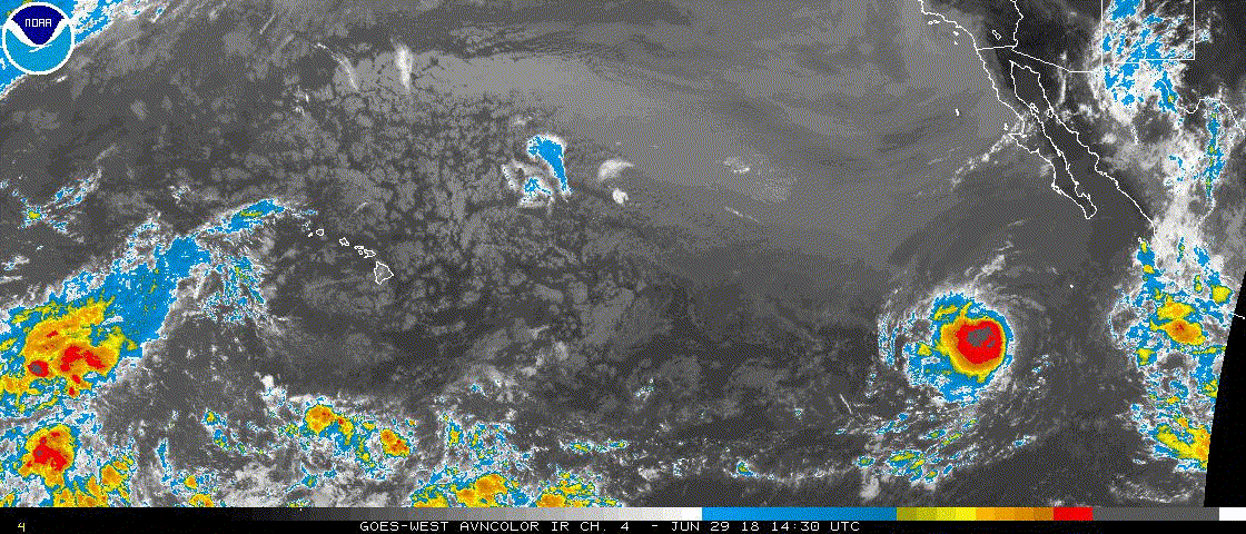
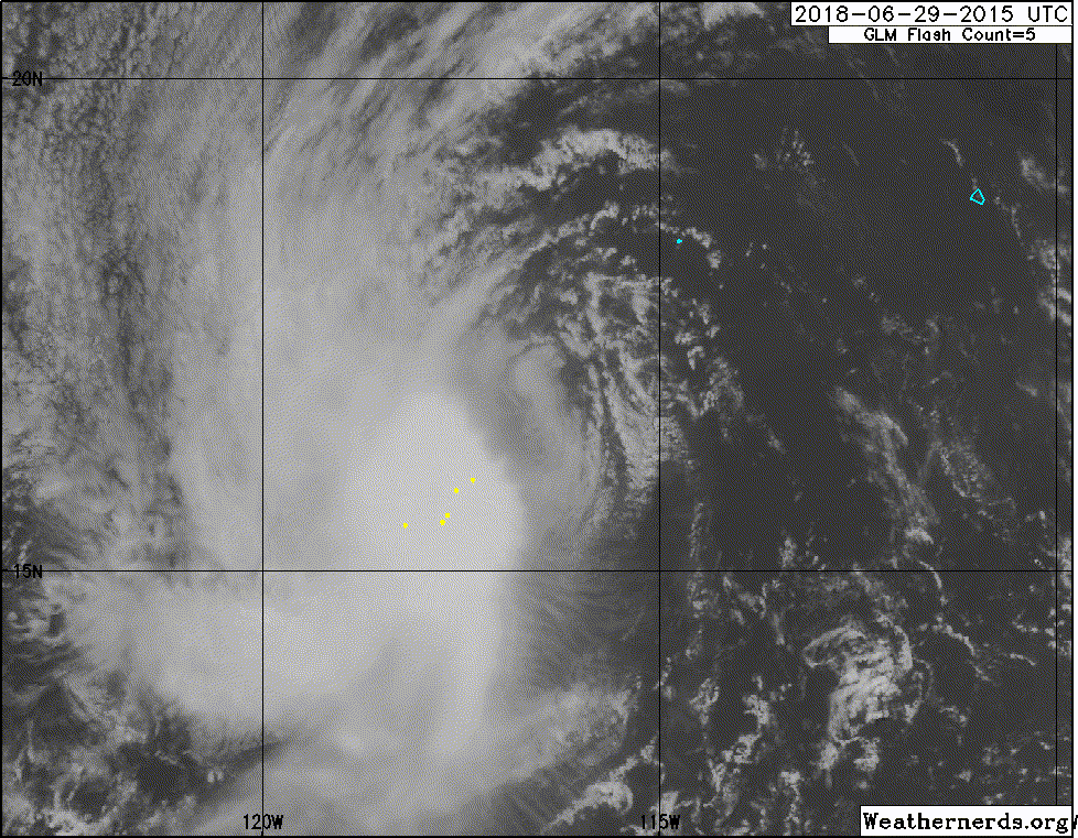
EPAC: EMILIA - Post-Tropical

Moderator: S2k Moderators

Message
Author
User avatar
Kingarabian
S2K Supporter
S2K Supporter
Posts: 15434
Joined: Sat Aug 08, 2009 3:06 am
Location: Honolulu, Hawaii

Re: EPAC: EMILIA - Tropical Storm

#81 Postby Kingarabian » Thu Jun 28, 2018 9:57 pm

CyclonicFury wrote:
Chris90 wrote:Slowly but surely Emilia is getting her act together.
I guessed Aletta would peak at 120-125kts, and Bud at 115kts, so I'm going to try again. I'll guess Emilia peaks at 75kts.

Anybody else want to take a guess just for fun?

I am going to guess 60 kts. Makes a run for hurricane status but ultimately falls short as it hits cool waters right as it begins to really get going.


Pretty spot on. I'll blend both of your estimates and go with 70kts :D.
1 likes   
RIP Kobe Bryant

User avatar
cycloneye
Admin
Admin
Posts: 139048
Age: 67
Joined: Thu Oct 10, 2002 10:54 am
Location: San Juan, Puerto Rico

Re: EPAC: EMILIA - Tropical Storm

#82 Postby cycloneye » Thu Jun 28, 2018 9:58 pm

I go with 65kts.
3 likes   
Visit the Caribbean-Central America Weather Thread where you can find at first post web cams,radars
and observations from Caribbean basin members Click Here

User avatar
Kingarabian
S2K Supporter
S2K Supporter
Posts: 15434
Joined: Sat Aug 08, 2009 3:06 am
Location: Honolulu, Hawaii

Re: EPAC: EMILIA - Tropical Storm

#83 Postby Kingarabian » Fri Jun 29, 2018 1:35 am

SAB up to 3.5.

TXPZ26 KNES 290621
TCSENP

A. 06E (EMILIA)

B. 29/0600Z

C. 16.0N

D. 116.0W

E. THREE/GOES-W

F. T3.5/3.5/D1.5/24HRS

G. IR/EIR/SWIR

H. REMARKS...CENTER LOCATION IS AT LEAST 1/3 DEGREE INTO DG RESULTING
IN DT=3.5. MET=3.0 AND PT=3.0. FT IS BASED ON DT.

I. ADDL POSITIONS

NIL
0 likes   
RIP Kobe Bryant

User avatar
Kingarabian
S2K Supporter
S2K Supporter
Posts: 15434
Joined: Sat Aug 08, 2009 3:06 am
Location: Honolulu, Hawaii

Re: EPAC: EMILIA - Tropical Storm

#84 Postby Kingarabian » Fri Jun 29, 2018 3:32 am

Corrected back to 3.0:

TXPZ26 KNES 290818
TCSENP
CCA

A. 06E (EMILIA)

B. 29/0600Z

C. 16.0N

D. 115.1W

E. THREE/GOES-W

F. T3.0/3.0/D1.0/24HRS

G. IR/EIR/SWIR/AMSU

H. REMARKS...CORRECTION FOR LONGITUDE POSITION. CENTER IS LESS THAN
1/2 FROM DG RESULTING IN A DT OF 3.0. MET AND PT AGREE AT 3.0. FT IS
BASED ON DT.

I. ADDL POSITIONS

29/0459Z 16.0N 114.9W AMSU


...KIBLER
0 likes   
RIP Kobe Bryant

User avatar
Kingarabian
S2K Supporter
S2K Supporter
Posts: 15434
Joined: Sat Aug 08, 2009 3:06 am
Location: Honolulu, Hawaii

Re: EPAC: EMILIA - Tropical Storm

#85 Postby Kingarabian » Fri Jun 29, 2018 3:41 am

000
WTPZ41 KNHC 290838
TCDEP1

Tropical Storm Emilia Discussion Number 7
NWS National Hurricane Center Miami FL EP062018
200 AM PDT Fri Jun 29 2018

Emilia has changed little in organization since the previous
advisory, with the convection continuing to be displaced to the
west and southwest of the low-level center by 15-20 kt of easterly
vertical wind shear. The initial intensity remains 45 kt based on
a blend of various satellite intensity estimates.

The initial motion is a somewhat uncertain 300/10. A low- to
mid-level subtropical ridge to the north of Emilia should steer the
cyclone generally west-northwestward through the forecast period,
and the track guidance is in good agreement with this scenario.
The new forecast track is an update of the previous forecast.

The dynamical model guidance suggests that the shear should
gradually decrease during the next 24-48 h. However, the sea
surface temperatures along the forecast track decrease during this
time, and it is uncertain if Emilia will be able to take advantage
of the more favorable upper-level winds. The new forecast follows
the trend of the previous forecast in showing slight strengthening
during this time. After 48 h, the cyclone is expected to move over
cool enough waters to cause steady weakening, and Emilia is
currently forecast to decay to a remnant low by 96 h.


FORECAST POSITIONS AND MAX WINDS

INIT 29/0900Z 16.0N 115.3W 45 KT 50 MPH
12H 29/1800Z 16.5N 116.8W 50 KT 60 MPH
24H 30/0600Z 17.2N 118.7W 55 KT 65 MPH
36H 30/1800Z 17.8N 120.5W 55 KT 65 MPH
48H 01/0600Z 18.4N 122.2W 50 KT 60 MPH
72H 02/0600Z 20.0N 126.0W 40 KT 45 MPH
96H 03/0600Z 21.5N 129.5W 25 KT 30 MPH...POST-TROP/REMNT LOW
120H 04/0600Z 23.0N 133.5W 20 KT 25 MPH...POST-TROP/REMNT LOW

$$
Forecaster Beven
0 likes   
RIP Kobe Bryant

User avatar
cycloneye
Admin
Admin
Posts: 139048
Age: 67
Joined: Thu Oct 10, 2002 10:54 am
Location: San Juan, Puerto Rico

Re: EPAC: EMILIA - Tropical Storm

#86 Postby cycloneye » Fri Jun 29, 2018 7:40 am

TXPZ26 KNES 291223
TCSENP

A. 06E (EMILIA)

B. 29/1200Z

C. 16.1N

D. 115.7W

E. THREE/GOES-W

F. T3.0/3.0/D1.0/24HRS

G. IR/EIR/SWIR

H. REMARKS...DT OF 3.0 IS BASED ON CENTER LT 0.5 DEG FROM DG. MET AND
PT ARE 3.0. FT IS BASED ON DT.

I. ADDL POSITIONS

NIL


...RAMIREZ
0 likes   
Visit the Caribbean-Central America Weather Thread where you can find at first post web cams,radars
and observations from Caribbean basin members Click Here

User avatar
cycloneye
Admin
Admin
Posts: 139048
Age: 67
Joined: Thu Oct 10, 2002 10:54 am
Location: San Juan, Puerto Rico

Re: EPAC: EMILIA - Tropical Storm

#87 Postby cycloneye » Fri Jun 29, 2018 7:42 am

Up to 50 kts.

EP, 06, 2018062912, , BEST, 0, 160N, 1159W, 50, 997, TS
0 likes   
Visit the Caribbean-Central America Weather Thread where you can find at first post web cams,radars
and observations from Caribbean basin members Click Here

User avatar
Yellow Evan
Professional-Met
Professional-Met
Posts: 15951
Age: 25
Joined: Fri Jul 15, 2011 12:48 pm
Location: Henderson, Nevada/Honolulu, HI
Contact:

Re: EPAC: EMILIA - Tropical Storm

#88 Postby Yellow Evan » Fri Jun 29, 2018 1:48 pm

000
WTPZ41 KNHC 291433
TCDEP1

Tropical Storm Emilia Discussion Number 8
NWS National Hurricane Center Miami FL EP062018
800 AM PDT Fri Jun 29 2018

Shortwave infrared imagery and an earlier 0855 UTC AMSR2 polar
orbiter pass show deep convective bursts, with associated
-78C cloud tops, developing near the surface center. The microwave
pass also revealed improved curved banding to the south of the
center. Based on these recent cloud pattern trends, it appears as
though the east-northeasterly shear is beginning to diminish, as
predicted by the SHIPS and LGEM intensity models. The initial
intensity is increased to 50 kt on this advisory based on a blend of
the Dvorak subjective T-numbers from TAFB and SAB, and an earlier
SATCON analysis of 50 kt.

Some further strengthening is still possible during the next 24
hours or so as the shear continues to relax. Afterward, decreasing
sea surface temperatures and a stabilizing air mass should initiate
a weakening trend. A majority of the large-scale models indicate
that Emily will degenerate into a remnant low in 4 days, if not
sooner. The NHC forecast follows suit and is based on the HCCA and
FSU Superensemble intensity consensus forecasts.

The initial motion is estimated to be 295/10 kt. Emily continues
to be steered by a relatively narrow low to mid-level tropospheric
ridge situated to the north. Global and hurricane models continue
to remain in good agreement with a general west-northwestward motion
until dissipation. The official forecast is slightly to the left
of the previous advisory and closely follows the HCCA and TVCN
consensus models through day 5.


FORECAST POSITIONS AND MAX WINDS

INIT 29/1500Z 16.2N 116.3W 50 KT 60 MPH
12H 30/0000Z 16.6N 117.8W 55 KT 65 MPH
24H 30/1200Z 17.2N 119.7W 55 KT 65 MPH
36H 01/0000Z 17.8N 121.6W 50 KT 60 MPH
48H 01/1200Z 18.5N 123.5W 45 KT 50 MPH
72H 02/1200Z 20.3N 127.1W 35 KT 40 MPH
96H 03/1200Z 21.7N 130.9W 25 KT 30 MPH...POST-TROP/REMNT LOW
120H 04/1200Z 22.7N 134.9W 20 KT 25 MPH...POST-TROP/REMNT LOW

$$
Forecaster Roberts
0 likes   

User avatar
Yellow Evan
Professional-Met
Professional-Met
Posts: 15951
Age: 25
Joined: Fri Jul 15, 2011 12:48 pm
Location: Henderson, Nevada/Honolulu, HI
Contact:

Re: EPAC: EMILIA - Tropical Storm

#89 Postby Yellow Evan » Fri Jun 29, 2018 1:50 pm

29/1800 UTC 16.4N 116.5W T3.0/3.0 EMILIA -- East Pacific
0 likes   

User avatar
Yellow Evan
Professional-Met
Professional-Met
Posts: 15951
Age: 25
Joined: Fri Jul 15, 2011 12:48 pm
Location: Henderson, Nevada/Honolulu, HI
Contact:

Re: EPAC: EMILIA - Tropical Storm

#90 Postby Yellow Evan » Fri Jun 29, 2018 1:51 pm

* EAST PACIFIC 2018 SHIPS INTENSITY FORECAST *
* IR SAT DATA AVAILABLE, OHC AVAILABLE *
* EMILIA EP062018 06/29/18 18 UTC *

TIME (HR) 0 6 12 18 24 36 48 60 72 84 96 108 120
V (KT) NO LAND 50 50 49 50 48 45 41 33 25 17 DIS DIS DIS
V (KT) LAND 50 50 49 50 48 45 41 33 25 17 DIS DIS DIS
V (KT) LGEM 50 51 52 51 49 45 40 33 26 20 17 DIS DIS
Storm Type TROP TROP TROP TROP TROP TROP TROP TROP TROP TROP TROP TROP TROP

SHEAR (KT) 17 15 11 4 3 7 12 15 16 21 20 24 31
SHEAR ADJ (KT) 0 1 -1 0 -1 0 5 2 4 2 6 13 16
SHEAR DIR 45 54 62 25 301 231 250 220 242 238 242 232 237
SST (C) 26.9 26.8 26.7 26.5 25.9 25.7 25.1 22.7 22.0 22.7 22.3 22.4 22.9
POT. INT. (KT) 133 132 131 128 122 120 114 89 81 89 85 86 91
200 MB T (C) -53.7 -53.4 -53.7 -53.5 -53.4 -53.3 -53.4 -53.0 -53.1 -52.9 -53.1 -52.8 -52.9
200 MB VXT (C) 0.1 0.1 0.3 0.4 0.4 0.5 0.6 0.5 0.6 0.5 0.5 0.6 0.1
TH_E DEV (C) 5 5 4 4 3 2 1 1 0 0 0 1 1
700-500 MB RH 61 62 59 59 59 59 55 47 43 37 33 31 28
MODEL VTX (KT) 22 22 22 23 21 20 19 16 14 13 12 10 8
850 MB ENV VOR 49 51 35 24 17 24 23 34 37 52 44 24 -8
200 MB DIV 26 26 -4 -17 -9 17 30 -3 -16 -39 -21 -12 -7
700-850 TADV -5 -2 -2 -1 0 3 6 8 -2 -2 0 2 2
LAND (KM) 992 1040 1073 1109 1152 1259 1348 1413 1494 1618 1784 1869 1955
LAT (DEG N) 16.4 16.7 17.0 17.3 17.6 18.2 19.0 19.9 20.8 21.6 22.0 22.5 23.1
LONG(DEG W) 116.5 117.5 118.4 119.4 120.3 122.2 124.1 125.9 127.6 129.5 131.6 133.6 135.5
STM SPEED (KT) 10 10 10 10 10 10 10 9 9 10 10 9 10
HEAT CONTENT 1 1 1 0 0 0 0 0 0 0 0 0 0

FORECAST TRACK FROM OFCI INITIAL HEADING/SPEED (DEG/KT):300/ 9 CX,CY: -7/ 5
T-12 MAX WIND: 45 PRESSURE OF STEERING LEVEL (MB): 578 (MEAN=584)
GOES IR BRIGHTNESS TEMP. STD DEV. 50-200 KM RAD: 24.4 (MEAN=14.5)
% GOES IR PIXELS WITH T < -20 C 50-200 KM RAD: 63.0 (MEAN=65.0)
PRELIM RI PROB (DV .GE. 55 KT IN 48 HR): 0.0

INDIVIDUAL CONTRIBUTIONS TO INTENSITY CHANGE
6 12 18 24 36 48 60 72 84 96 108 120
----------------------------------------------------------
SAMPLE MEAN CHANGE 0. 0. 1. 1. 1. 1. 1. 0. -1. -1. -2. -3.
SST POTENTIAL 1. 1. 2. 3. 4. 5. 4. 3. 1. 0. -2. -2.
VERTICAL SHEAR MAG 0. 0. 0. 1. 3. 3. 2. 1. -2. -4. -6. -9.
VERTICAL SHEAR ADJ 0. 0. 0. 0. 0. 0. 0. 0. 0. 1. 1. 2.
VERTICAL SHEAR DIR 0. 1. 1. 1. 0. -1. -2. -2. -2. -2. -1. -1.
PERSISTENCE 1. 2. 2. 2. 1. 1. 1. 0. 0. 1. 1. 0.
200/250 MB TEMP. 0. 0. 0. 0. 0. 0. 0. 1. 2. 2. 3. 3.
THETA_E EXCESS 0. 0. -1. -1. -3. -5. -6. -8. -9. -11. -12. -13.
700-500 MB RH 0. 0. 0. 0. 0. -1. -1. -2. -2. -3. -3. -4.
MODEL VTX TENDENCY 0. 0. 0. -1. -2. -3. -7. -11. -13. -15. -16. -20.
850 MB ENV VORTICITY 0. 0. 0. 0. 0. 0. 0. 0. 0. 0. 0. 0.
200 MB DIVERGENCE 0. 0. -1. -1. -1. -1. -2. -3. -4. -4. -5. -5.
850-700 T ADVEC 0. 0. 0. 0. 0. 0. 0. 0. 0. 1. 1. 1.
ZONAL STORM MOTION 0. 0. 0. 0. 0. 0. 0. 0. 0. 0. 0. 0.
STEERING LEVEL PRES 0. 0. 0. 0. 0. 0. 0. 0. 0. 0. 0. 0.
DAYS FROM CLIM. PEAK 0. 0. 0. 0. 0. 0. -1. -1. -1. -2. -2. -2.
GOES PREDICTORS -1. -2. -3. -4. -4. -3. -3. -3. -2. -2. -2. -2.
OCEAN HEAT CONTENT 0. 0. -1. -1. -1. -1. -1. 0. 0. 0. 0. 0.
RI POTENTIAL 0. 0. -1. -1. -2. -3. -3. -2. 0. 1. 2. 3.
----------------------------------------------------------
TOTAL CHANGE 0. -1. 0. -2. -5. -9. -17. -25. -33. -38. -44. -50.

CURRENT MAX WIND (KT): 50. LAT, LON: 16.4 116.5

** 2018 E. Pacific RI INDEX EP062018 EMILIA 06/29/18 18 UTC **
(SHIPS-RII PREDICTOR TABLE for 30 KT OR MORE MAXIMUM WIND INCREASE IN NEXT 24-h)

Predictor Value RI Predictor Range Scaled Value(0-1) % Contribution
POT = MPI-VMAX (KT) : 73.3 40.5 to 149.3 0.30 999.0
12 HR PERSISTENCE (KT) : 5.0 -22.0 to 44.0 0.41 999.0
850-200 MB SHEAR (KT) : 10.2 19.6 to 1.4 0.52 999.0
HEAT CONTENT (KJ/CM2) : 0.6 1.8 to 106.7 0.00 0.0
D200 (10**7s-1) : 4.4 -33.0 to 156.2 0.20 999.0
STD DEV OF IR BR TEMP : 24.4 37.8 to 2.1 0.38 999.0
MAXIMUM WIND (KT) : 50.0 22.5 to 132.0 0.80 999.0
BL DRY-AIR FLUX (W/M2) : 300.0 721.6 to -82.5 0.52 999.0
%area of TPW <45 mm upshear : 0.0 62.3 to 0.0 1.00 999.0
2nd PC OF IR BR TEMP : -2.1 2.2 to -1.9 1.00 999.0

SHIPS Prob RI for 20kt/ 12hr RI threshold= 4% is 0.7 times climatological mean ( 6.1%)
SHIPS Prob RI for 25kt/ 24hr RI threshold= 12% is 1.0 times climatological mean (12.5%)
SHIPS Prob RI for 30kt/ 24hr RI threshold= 0% is 0.0 times climatological mean ( 8.4%)
SHIPS Prob RI for 35kt/ 24hr RI threshold= 0% is 0.0 times climatological mean ( 6.0%)
SHIPS Prob RI for 40kt/ 24hr RI threshold= 0% is 0.0 times climatological mean ( 4.0%)
SHIPS Prob RI for 45kt/ 36hr RI threshold= 0% is 0.0 times climatological mean ( 6.5%)
SHIPS Prob RI for 55kt/ 48hr RI threshold= 0% is 0.0 times climatological mean ( 5.9%)
SHIPS Prob RI for 65kt/ 72hr RI threshold= 0% is 0.0 times climatological mean ( 4.8%)

Matrix of RI probabilities
------------------------------------------------------------------------------
RI (kt / h) | 20/12 | 25/24 | 30/24 | 35/24 | 40/24 | 45/36 | 55/48 |65/72
------------------------------------------------------------------------------
SHIPS-RII: 4.4% 12.0% 0.0% 0.0% 0.0% 0.0% 0.0% 0.0%
Logistic: 0.3% 1.2% 0.6% 0.2% 0.1% 0.1% 0.0% 0.0%
Bayesian: 0.0% 0.0% 0.0% 0.0% 0.0% 0.0% 0.0% 0.0%
Consensus: 1.6% 4.4% 0.2% 0.1% 0.0% 0.0% 0.0% 0.0%
DTOPS: 2.0% 3.0% 2.0% 1.0% 1.0% 1.0% 0.0% 0.0%

## ANNULAR HURRICANE INDEX (AHI) EP062018 EMILIA 06/29/18 18 UTC ##
## STORM NOT ANNULAR, SCREENING STEP FAILED, NPASS=4 NFAIL=3 ##
## AHI= 0 (AHI OF 100 IS BEST FIT TO ANN. STRUC., 1 IS MARGINAL, 0 IS NOT ANNULAR) ##
0 likes   

User avatar
cycloneye
Admin
Admin
Posts: 139048
Age: 67
Joined: Thu Oct 10, 2002 10:54 am
Location: San Juan, Puerto Rico

Re: EPAC: EMILIA - Tropical Storm

#91 Postby cycloneye » Fri Jun 29, 2018 3:33 pm

Tropical Storm Emilia Discussion Number 9
NWS National Hurricane Center Miami FL EP062018
200 PM PDT Fri Jun 29 2018

Emilia remains a sheared tropical cyclone, as visible satellite
images show that the center is located near the northeastern edge of
a large mass of deep convection. The center has become a little
more exposed this afternoon, but Dvorak Data T-numbers are unchanged
from this morning and the initial intensity is kept at 50 kt for
this advisory. Although the shear is forecast to decrease during
the next 24 hours, the cyclone will be moving over gradually
decreasing SSTs, so little overall change in strength is anticipated
during that time. By late Saturday, Emilia is forecast to cross the
26 degree isotherm and move into a less favorable thermodynamic
environment, which should initiate weakening. Dry air and cool
waters should accelerate the spin down and Emilia is forecast to
degenerate into a remnant low in about 72 hours, if not sooner.

The initial motion estimate is 295/9 kt. Emilia should continue
moving west-northwestward to the south of a low to mid-level ridge.
After weakening, a more westward motion is forecast as the system
comes under the influence of the low-level trade wind flow. The
track guidance remains in good agreement and the updated official
foreast is near the center of the guidance envelope.

FORECAST POSITIONS AND MAX WINDS

INIT 29/2100Z 16.6N 116.9W 50 KT 60 MPH
12H 30/0600Z 17.0N 118.3W 50 KT 60 MPH
24H 30/1800Z 17.5N 120.2W 50 KT 60 MPH
36H 01/0600Z 18.3N 122.1W 45 KT 50 MPH
48H 01/1800Z 19.1N 123.8W 40 KT 45 MPH
72H 02/1800Z 21.0N 127.7W 30 KT 35 MPH...POST-TROP/REMNT LOW
96H 03/1800Z 22.1N 131.6W 25 KT 30 MPH...POST-TROP/REMNT LOW
120H 04/1800Z 22.5N 136.5W 20 KT 25 MPH...POST-TROP/REMNT LOW

$$
Forecaster Brown
0 likes   
Visit the Caribbean-Central America Weather Thread where you can find at first post web cams,radars
and observations from Caribbean basin members Click Here

hurricanes1234
Category 5
Category 5
Posts: 2903
Joined: Sat Jul 28, 2012 6:19 pm
Location: Trinidad and Tobago

Re: EPAC: EMILIA - Tropical Storm

#92 Postby hurricanes1234 » Fri Jun 29, 2018 3:46 pm

I'm thinking too that this probably won't intensify any further from here. It seems as though shear is still affecting it and there's not really much time before colder water starts weakening it.
0 likes   
PLEASE NOTE: With the exception of information from weather agencies that I may copy and paste here, my posts will NEVER be official, since I am NOT a meteorologist. They are solely my amateur opinion, and may or may not be accurate. Therefore, please DO NOT use them as official details, particularly when making important decisions. Thank you.

Sciencerocks
Category 5
Category 5
Posts: 7282
Age: 38
Joined: Thu Jul 06, 2017 1:51 am

Re: EPAC: EMILIA - Tropical Storm

#93 Postby Sciencerocks » Fri Jun 29, 2018 5:57 pm

Image
0 likes   

User avatar
Yellow Evan
Professional-Met
Professional-Met
Posts: 15951
Age: 25
Joined: Fri Jul 15, 2011 12:48 pm
Location: Henderson, Nevada/Honolulu, HI
Contact:

Re: EPAC: EMILIA - Tropical Storm

#94 Postby Yellow Evan » Fri Jun 29, 2018 6:01 pm

hurricanes1234 wrote:I'm thinking too that this probably won't intensify any further from here. It seems as though shear is still affecting it and there's not really much time before colder water starts weakening it.


If shear relaxes (and that's what generally been forecast by the SHIPS output), there's a small window for it to intensify before SST's get below 26C in 18 hours or so.
0 likes   

Sciencerocks
Category 5
Category 5
Posts: 7282
Age: 38
Joined: Thu Jul 06, 2017 1:51 am

Re: EPAC: EMILIA - Tropical Storm

#95 Postby Sciencerocks » Fri Jun 29, 2018 6:30 pm

Image
0 likes   

hurricanes1234
Category 5
Category 5
Posts: 2903
Joined: Sat Jul 28, 2012 6:19 pm
Location: Trinidad and Tobago

Re: EPAC: EMILIA - Tropical Storm

#96 Postby hurricanes1234 » Fri Jun 29, 2018 6:56 pm

Has the classic shear profile with the centre almost totally exposed to the east of a blob of deep convection. With time running out, I'd say at best this strengthens about 5 knots, if at all, before weakening. I doubt it becomes a hurricane but we'll see.
0 likes   
PLEASE NOTE: With the exception of information from weather agencies that I may copy and paste here, my posts will NEVER be official, since I am NOT a meteorologist. They are solely my amateur opinion, and may or may not be accurate. Therefore, please DO NOT use them as official details, particularly when making important decisions. Thank you.

User avatar
cycloneye
Admin
Admin
Posts: 139048
Age: 67
Joined: Thu Oct 10, 2002 10:54 am
Location: San Juan, Puerto Rico

Re: EPAC: EMILIA - Tropical Storm

#97 Postby cycloneye » Fri Jun 29, 2018 7:36 pm

Down to 40 kts.

EP, 06, 2018063000, , BEST, 0, 166N, 1173W, 40, 1000, TS
0 likes   
Visit the Caribbean-Central America Weather Thread where you can find at first post web cams,radars
and observations from Caribbean basin members Click Here

User avatar
Yellow Evan
Professional-Met
Professional-Met
Posts: 15951
Age: 25
Joined: Fri Jul 15, 2011 12:48 pm
Location: Henderson, Nevada/Honolulu, HI
Contact:

Re: EPAC: EMILIA - Tropical Storm

#98 Postby Yellow Evan » Fri Jun 29, 2018 7:48 pm

* EAST PACIFIC 2018 SHIPS INTENSITY FORECAST *
* IR SAT DATA AVAILABLE, OHC AVAILABLE *
* EMILIA EP062018 06/30/18 00 UTC *

TIME (HR) 0 6 12 18 24 36 48 60 72 84 96 108 120
V (KT) NO LAND 40 37 36 34 32 31 28 23 16 DIS DIS DIS DIS
V (KT) LAND 40 37 36 34 32 31 28 23 16 DIS DIS DIS DIS
V (KT) LGEM 40 37 34 32 31 27 24 19 16 DIS DIS DIS DIS
Storm Type TROP TROP TROP TROP TROP TROP TROP TROP TROP TROP TROP TROP TROP

SHEAR (KT) 17 10 4 2 6 10 11 17 16 23 21 29 30
SHEAR ADJ (KT) 0 -2 0 1 -1 0 6 0 2 0 6 14 12
SHEAR DIR 53 61 20 308 254 257 231 235 239 247 250 260 252
SST (C) 26.8 26.7 26.7 26.4 25.4 25.7 24.3 21.9 22.2 22.8 22.0 23.0 23.3
POT. INT. (KT) 131 130 131 128 117 120 106 81 84 90 82 93 97
200 MB T (C) -53.4 -53.6 -53.5 -53.3 -53.2 -53.5 -53.2 -53.2 -52.9 -52.9 -53.0 -52.9 -53.4
200 MB VXT (C) 0.2 0.3 0.4 0.4 0.5 0.6 0.5 0.4 0.6 0.5 0.6 0.4 0.4
TH_E DEV (C) 6 5 4 3 3 2 1 0 0 0 1 2 3
700-500 MB RH 62 58 63 58 59 58 52 44 37 35 32 29 23
MODEL VTX (KT) 19 20 20 19 18 18 15 14 12 11 9 8 6
850 MB ENV VOR 48 39 33 14 12 19 24 40 41 47 21 23 0
200 MB DIV 24 -1 0 -7 4 14 19 -20 -35 -33 -19 -30 -11
700-850 TADV -1 -1 0 1 2 0 9 0 -2 4 4 1 2
LAND (KM) 1036 1080 1118 1157 1205 1291 1360 1434 1553 1704 1842 1992 1785
LAT (DEG N) 16.6 16.8 17.0 17.4 17.7 18.5 19.3 20.3 21.3 21.9 21.9 22.1 22.5
LONG(DEG W) 117.3 118.2 119.1 120.1 121.1 122.8 124.6 126.5 128.6 130.6 132.4 134.9 137.9
STM SPEED (KT) 9 9 10 10 10 9 10 11 10 9 10 13 14
HEAT CONTENT 1 1 1 0 0 0 0 0 0 0 0 0 0

FORECAST TRACK FROM OFCI INITIAL HEADING/SPEED (DEG/KT):295/ 8 CX,CY: -6/ 3
T-12 MAX WIND: 50 PRESSURE OF STEERING LEVEL (MB): 546 (MEAN=584)
GOES IR BRIGHTNESS TEMP. STD DEV. 50-200 KM RAD: 25.1 (MEAN=14.5)
% GOES IR PIXELS WITH T < -20 C 50-200 KM RAD: 51.0 (MEAN=65.0)
PRELIM RI PROB (DV .GE. 55 KT IN 48 HR): 0.0

INDIVIDUAL CONTRIBUTIONS TO INTENSITY CHANGE
6 12 18 24 36 48 60 72 84 96 108 120
----------------------------------------------------------
SAMPLE MEAN CHANGE 0. 0. 1. 1. 1. 1. 1. 0. -1. -1. -2. -3.
SST POTENTIAL 1. 1. 2. 3. 5. 7. 9. 9. 9. 8. 7. 7.
VERTICAL SHEAR MAG 0. 1. 2. 3. 4. 4. 3. 1. -3. -6. -8. -11.
VERTICAL SHEAR ADJ 0. 0. 0. 0. 0. 0. 0. 0. 0. 0. 1. 2.
VERTICAL SHEAR DIR 0. 1. 0. 0. -1. -2. -3. -3. -2. -2. -1. -1.
PERSISTENCE -3. -4. -5. -5. -5. -4. -3. -2. -2. -2. -1. 0.
200/250 MB TEMP. 0. 0. 0. 0. 0. 0. 0. 1. 2. 3. 3. 3.
THETA_E EXCESS 0. 0. -1. -1. -3. -5. -7. -8. -10. -11. -12. -12.
700-500 MB RH 0. 0. 0. 0. 0. -1. -1. -2. -3. -3. -4. -5.
MODEL VTX TENDENCY 0. 1. 0. -1. -1. -3. -6. -10. -11. -14. -15. -18.
850 MB ENV VORTICITY 0. 0. 0. 0. 0. 0. 0. 0. 0. 0. 0. 0.
200 MB DIVERGENCE 0. 0. -1. -1. -2. -2. -2. -3. -4. -5. -5. -5.
850-700 T ADVEC 0. 0. 0. 0. 0. 0. 0. 0. 1. 1. 1. 1.
ZONAL STORM MOTION 0. 0. 0. 0. 0. 0. 0. 0. 0. 0. 0. 0.
STEERING LEVEL PRES 0. 0. 0. 0. 0. 0. 0. 0. 0. 0. 0. -1.
DAYS FROM CLIM. PEAK 0. 0. 0. 0. 0. 0. -1. -1. -1. -2. -2. -2.
GOES PREDICTORS -1. -2. -3. -3. -4. -4. -4. -4. -3. -3. -3. -4.
OCEAN HEAT CONTENT 0. 0. -1. -1. -1. -1. -1. 0. 0. 0. 0. 0.
RI POTENTIAL 0. 0. -1. -1. -2. -3. -3. -2. 0. 1. 2. 3.
----------------------------------------------------------
TOTAL CHANGE -3. -4. -6. -8. -9. -12. -17. -24. -30. -36. -41. -46.

CURRENT MAX WIND (KT): 40. LAT, LON: 16.6 117.3

** 2018 E. Pacific RI INDEX EP062018 EMILIA 06/30/18 00 UTC **
(SHIPS-RII PREDICTOR TABLE for 30 KT OR MORE MAXIMUM WIND INCREASE IN NEXT 24-h)

Predictor Value RI Predictor Range Scaled Value(0-1) % Contribution
POT = MPI-VMAX (KT) : 79.6 40.5 to 149.3 0.36 999.0
12 HR PERSISTENCE (KT) : -10.0 -22.0 to 44.0 0.18 999.0
850-200 MB SHEAR (KT) : 8.0 19.6 to 1.4 0.64 999.0
HEAT CONTENT (KJ/CM2) : 0.6 1.8 to 106.7 0.00 0.0
D200 (10**7s-1) : 4.0 -33.0 to 156.2 0.20 999.0
STD DEV OF IR BR TEMP : 25.1 37.8 to 2.1 0.36 999.0
MAXIMUM WIND (KT) : 40.0 22.5 to 132.0 0.51 999.0
BL DRY-AIR FLUX (W/M2) : 237.6 721.6 to -82.5 0.60 999.0
%area of TPW <45 mm upshear : 0.0 62.3 to 0.0 1.00 999.0
2nd PC OF IR BR TEMP : -2.3 2.2 to -1.9 1.00 999.0

SHIPS Prob RI for 20kt/ 12hr RI threshold= 2% is 0.3 times climatological mean ( 6.1%)
SHIPS Prob RI for 25kt/ 24hr RI threshold= 6% is 0.5 times climatological mean (12.5%)
SHIPS Prob RI for 30kt/ 24hr RI threshold= 0% is 0.0 times climatological mean ( 8.4%)
SHIPS Prob RI for 35kt/ 24hr RI threshold= 0% is 0.0 times climatological mean ( 6.0%)
SHIPS Prob RI for 40kt/ 24hr RI threshold= 0% is 0.0 times climatological mean ( 4.0%)
SHIPS Prob RI for 45kt/ 36hr RI threshold= 0% is 0.0 times climatological mean ( 6.5%)
SHIPS Prob RI for 55kt/ 48hr RI threshold= 0% is 0.0 times climatological mean ( 5.9%)
SHIPS Prob RI for 65kt/ 72hr RI threshold= 0% is 0.0 times climatological mean ( 4.8%)

Matrix of RI probabilities
------------------------------------------------------------------------------
RI (kt / h) | 20/12 | 25/24 | 30/24 | 35/24 | 40/24 | 45/36 | 55/48 |65/72
------------------------------------------------------------------------------
SHIPS-RII: 1.6% 6.5% 0.0% 0.0% 0.0% 0.0% 0.0% 0.0%
Logistic: 0.1% 0.2% 0.1% 0.0% 0.0% 0.0% 0.0% 0.0%
Bayesian: 0.0% 0.0% 0.0% 0.0% 0.0% 0.0% 0.0% 0.0%
Consensus: 0.5% 2.2% 0.0% 0.0% 0.0% 0.0% 0.0% 0.0%
DTOPS: 0.0% 0.0% 0.0% 0.0% 0.0% 0.0% 0.0% 1.0%

## ANNULAR HURRICANE INDEX (AHI) EP062018 EMILIA 06/30/18 00 UTC ##
## STORM NOT ANNULAR, SCREENING STEP FAILED, NPASS=6 NFAIL=1 ##
## AHI= 0 (AHI OF 100 IS BEST FIT TO ANN. STRUC., 1 IS MARGINAL, 0 IS NOT ANNULAR) ##

CONTRIBUTIONS TO ANNULAR INDEX
0 likes   

User avatar
cycloneye
Admin
Admin
Posts: 139048
Age: 67
Joined: Thu Oct 10, 2002 10:54 am
Location: San Juan, Puerto Rico

Re: EPAC: EMILIA - Tropical Storm

#99 Postby cycloneye » Fri Jun 29, 2018 9:33 pm

Tropical Storm Emilia Discussion Number 10
NWS National Hurricane Center Miami FL EP062018
800 PM PDT Fri Jun 29 2018

The cloud pattern has become less organized tonight. The center is
even more separated from the main convection than earlier today,
while the low-level circulation is becoming somewhat elongated.
This is a result of a persistent easterly shear and the effect of
cooler waters. Based on the current pattern and the decrease in the
Dvorak numbers, the initial intensity has been lowered to 40 kt in
this advisory. Emilia could still maintain tropical storm status for
a day or so, but given the environmental conditions of shear and
cool waters, the NHC forecast calls for weakening and Emilia could
become a remnant low in 3 days or even sooner.

The initial motion is toward the west-northwest or 290 at 10 kt.
The cyclone should continue to be steered on the same direction
for the next few days by the flow south of a subtropical ridge. The
NHC forecast is very near the HFIP Corrected consensus HCCA which is
in the middle of the guidance envelope.

FORECAST POSITIONS AND MAX WINDS

INIT 30/0300Z 16.8N 117.8W 40 KT 45 MPH
12H 30/1200Z 17.2N 119.2W 35 KT 40 MPH
24H 01/0000Z 17.8N 121.2W 35 KT 40 MPH
36H 01/1200Z 18.5N 123.0W 35 KT 40 MPH
48H 02/0000Z 19.5N 124.8W 30 KT 35 MPH
72H 03/0000Z 21.5N 128.5W 25 KT 30 MPH...POST-TROP/REMNT LOW
96H 04/0000Z 22.2N 133.0W 20 KT 25 MPH...POST-TROP/REMNT LOW
120H 05/0000Z...DISSIPATED

$$
Forecaster Avila
0 likes   
Visit the Caribbean-Central America Weather Thread where you can find at first post web cams,radars
and observations from Caribbean basin members Click Here

hurricanes1234
Category 5
Category 5
Posts: 2903
Joined: Sat Jul 28, 2012 6:19 pm
Location: Trinidad and Tobago

Re: EPAC: EMILIA - Tropical Storm

#100 Postby hurricanes1234 » Fri Jun 29, 2018 9:43 pm

Looks like this demise is occurring sooner than I thought! :lol:
0 likes   
PLEASE NOTE: With the exception of information from weather agencies that I may copy and paste here, my posts will NEVER be official, since I am NOT a meteorologist. They are solely my amateur opinion, and may or may not be accurate. Therefore, please DO NOT use them as official details, particularly when making important decisions. Thank you.


Return to “2018”

Who is online

Users browsing this forum: No registered users and 31 guests