
EPAC: FABIO - Post-Tropical
Moderator: S2k Moderators
-
Kingarabian

- S2K Supporter

- Posts: 15434
- Joined: Sat Aug 08, 2009 3:06 am
- Location: Honolulu, Hawaii
Re: EPAC: FABIO - Hurricane
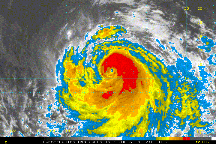
No doubt in my mind that this is a major hurricane now:
1 likes
RIP Kobe Bryant
Re: EPAC: FABIO - Hurricane
Eye is warming. I thought it was going for a 5.5 look but it may end up more like a 6.0.

0 likes
-
hurricanes1234
- Category 5

- Posts: 2903
- Joined: Sat Jul 28, 2012 6:19 pm
- Location: Trinidad and Tobago
Re: EPAC: FABIO - Hurricane
IMO it's possible that this could narrowly miss major hurricane status like its 2012 version, provided the improvement trend that began earlier today doesn't sustain itself.
1 likes
PLEASE NOTE: With the exception of information from weather agencies that I may copy and paste here, my posts will NEVER be official, since I am NOT a meteorologist. They are solely my amateur opinion, and may or may not be accurate. Therefore, please DO NOT use them as official details, particularly when making important decisions. Thank you.
-
cycloneye

- Admin

- Posts: 139049
- Age: 67
- Joined: Thu Oct 10, 2002 10:54 am
- Location: San Juan, Puerto Rico
Re: EPAC: FABIO - Hurricane
It has peaked.
04/0000 UTC 16.2N 117.3W T4.5/5.0 FABIO
3 likes
Visit the Caribbean-Central America Weather Thread where you can find at first post web cams,radars
and observations from Caribbean basin members Click Here
and observations from Caribbean basin members Click Here
-
mrbagyo

- Category 5
- Posts: 3614
- Age: 31
- Joined: Thu Apr 12, 2012 9:18 am
- Location: 14.13N 120.98E
- Contact:
Re: EPAC: FABIO - Hurricane
It appears Fabio hit the break pedal.
Looks like it ingested considerable amount of dry air.
Looks like it ingested considerable amount of dry air.
1 likes
The posts in this forum are NOT official forecast and should not be used as such. They are just the opinion of the poster and may or may not be backed by sound meteorological data. They are NOT endorsed by any professional institution or storm2k.org. For official information, please refer to RSMC, NHC and NWS products.
-
hurricanes1234
- Category 5
- Posts: 2903
- Joined: Sat Jul 28, 2012 6:19 pm
- Location: Trinidad and Tobago
Re: EPAC: FABIO - Hurricane
mrbagyo wrote:It appears Fabio hit the break pedal.
Looks like it ingested considerable amount of dry air.
Agreed. I mean, not as though it ever hit the gas pedal in the first place.
All the persistent, aggressive RI forecasts and projections from many models instead amounted to a hurricane struggling to sort out its structure and repeatedly ingesting dry air. Its time over favourable SSTs will likely be up very soon, if not already, so I'd join you guys as well in guessing that it has indeed peaked.
1 likes
PLEASE NOTE: With the exception of information from weather agencies that I may copy and paste here, my posts will NEVER be official, since I am NOT a meteorologist. They are solely my amateur opinion, and may or may not be accurate. Therefore, please DO NOT use them as official details, particularly when making important decisions. Thank you.
-
cycloneye
- Admin
- Posts: 139049
- Age: 67
- Joined: Thu Oct 10, 2002 10:54 am
- Location: San Juan, Puerto Rico
Re: EPAC: FABIO - Hurricane
Stays at 95 kts.
EP, 07, 2018070400, , BEST, 0, 162N, 1173W, 95, 964, H
0 likes
Visit the Caribbean-Central America Weather Thread where you can find at first post web cams,radars
and observations from Caribbean basin members Click Here
and observations from Caribbean basin members Click Here
-
Kingarabian
- S2K Supporter
- Posts: 15434
- Joined: Sat Aug 08, 2009 3:06 am
- Location: Honolulu, Hawaii
-
CyclonicFury

- Category 5
- Posts: 1973
- Age: 25
- Joined: Sun Jul 02, 2017 12:32 pm
- Location: NC
- Contact:
Re: EPAC: FABIO - Hurricane
Don't think Fabio will be able to reach major hurricane strength now. It's very close to crossing the 26C isotherm. Wouldn't rule out a post-season upgrade though, because of the very high ADT T-numbers earlier today.
2 likes
NCSU B.S. in Meteorology Class of 2021. Tropical weather blogger at http://www.cyclonicfury.com. My forecasts and thoughts are NOT official, for official forecasts please consult the National Hurricane Center.
-
Kingarabian
- S2K Supporter
- Posts: 15434
- Joined: Sat Aug 08, 2009 3:06 am
- Location: Honolulu, Hawaii
Re: EPAC: FABIO - Hurricane
It was at least a minimal Major hurricane 2-3 hours ago. Think we see it upgraded in the off season.
1 likes
RIP Kobe Bryant
-
cycloneye
- Admin
- Posts: 139049
- Age: 67
- Joined: Thu Oct 10, 2002 10:54 am
- Location: San Juan, Puerto Rico
Re: EPAC: FABIO - Hurricane
Kingarabian wrote:It was at least a minimal Major hurricane 2-3 hours ago. Think we see it upgraded in the off season.
Agreed.They will revisit Fabio after season is over.
1 likes
Visit the Caribbean-Central America Weather Thread where you can find at first post web cams,radars
and observations from Caribbean basin members Click Here
and observations from Caribbean basin members Click Here
-
NotSparta

- Professional-Met

- Posts: 1646
- Age: 22
- Joined: Fri Aug 18, 2017 8:24 am
- Location: Naples, FL
- Contact:
Re: EPAC: FABIO - Hurricane
Kingarabian wrote:It was at least a minimal Major hurricane 2-3 hours ago. Think we see it upgraded in the off season.
Agree. Another case of peaking between advisories so that the NHC can't report the true peak
2 likes
This post was probably an opinion of mine, and in no way is official. Please refer to http://www.hurricanes.gov for official tropical analysis and advisories.
My website, with lots of tropical wx graphics, including satellite and recon: http://cyclonicwx.com
My website, with lots of tropical wx graphics, including satellite and recon: http://cyclonicwx.com
-
cycloneye
- Admin
- Posts: 139049
- Age: 67
- Joined: Thu Oct 10, 2002 10:54 am
- Location: San Juan, Puerto Rico
Re: EPAC: FABIO - Hurricane
Hurricane Fabio Discussion Number 14
NWS National Hurricane Center Miami FL EP072018
800 PM PDT Tue Jul 03 2018
The intensification trend of Fabio appears to have ended. Several
hours ago, satellite images showed a ring of cold cloud tops
surrounding a distinct eye. However, more recent data indicate that
the structure of Fabio has deteriorated with a pronounced dry slot
evident on the east side of the circulation. Blending the latest
intensity estimates from TAFB, SAB, and CIMSS at the University of
Wisconsin support holding the initial wind speed at 95 kt, but this
could be a little generous.
Fabio is currently over marginally warm 27 degree C waters, but it
is headed for much cooler waters during the next several days. These
unfavorable oceanic conditions combined with a more stable airmass
and an increase in southwesterly shear should cause steady weakening
through the forecast period. Fabio is forecast to weaken below
hurricane strength in 36 to 48 hours, and it is predicted to become
a remnant low by 96 hours. The intensity models are in fair
agreement, and the NHC forecast lies between the HCCA and ICON
consensus aids.
The hurricane continues to move west-northwestward at 13 kt. There
is no change to the track forecast reasoning. Fabio is expected to
continue west-northwestward to northwestward at about the same
forward speed during the next few days while it moves on the
southwestern periphery of a mid-level ridge. By the end of the
forecast period, when Fabio is a weak and shallow system, the
cyclone is predicted to slow down as it becomes more influenced by
the low-level flow. The track models remain in good agreement, and
the NHC forecast lies near the middle of the guidance envelope.
FORECAST POSITIONS AND MAX WINDS
INIT 04/0300Z 16.5N 117.9W 95 KT 110 MPH
12H 04/1200Z 17.4N 119.7W 90 KT 105 MPH
24H 05/0000Z 18.9N 122.2W 80 KT 90 MPH
36H 05/1200Z 20.4N 124.7W 65 KT 75 MPH
48H 06/0000Z 22.0N 127.0W 50 KT 60 MPH
72H 07/0000Z 24.8N 131.1W 40 KT 45 MPH
96H 08/0000Z 26.7N 135.0W 30 KT 35 MPH...POST-TROP/REMNT LOW
120H 09/0000Z 28.1N 138.0W 25 KT 30 MPH...POST-TROP/REMNT LOW
$$
Forecaster Cangialosi
0 likes
Visit the Caribbean-Central America Weather Thread where you can find at first post web cams,radars
and observations from Caribbean basin members Click Here
and observations from Caribbean basin members Click Here
-
Yellow Evan

- Professional-Met
- Posts: 15951
- Age: 25
- Joined: Fri Jul 15, 2011 12:48 pm
- Location: Henderson, Nevada/Honolulu, HI
- Contact:
Re: EPAC: FABIO - Hurricane
CyclonicFury wrote:Don't think Fabio will be able to reach major hurricane strength now. It's very close to crossing the 26C isotherm. Wouldn't rule out a post-season upgrade though, because of the very high ADT T-numbers earlier today.
SAB and TAFB never got over 5.0 though.
0 likes
-
cycloneye
- Admin
- Posts: 139049
- Age: 67
- Joined: Thu Oct 10, 2002 10:54 am
- Location: San Juan, Puerto Rico
Re: EPAC: FABIO - Hurricane
Hurricane Fabio Discussion Number 15
NWS National Hurricane Center Miami FL EP072018
200 AM PDT Wed Jul 04 2018
The eye continues to be distinct, but the convective tops are
warming and the area coverage is shrinking. An average of the TAFB
and SAB Dvorak T-numbers supports an initial intensity of 90 kt.
Fabio's core is still moving over 26 or 27 degree C waters, but the
northern circulation is already encountering much cooler waters. On
this basis, NHC forecast weakening, and Fabio is anticipated to be a
remnant low in 3 days when its core moves over 20 degree C waters.
There has been no change in track, and Fabio continues to move
west-northwestward at 13 kt. The hurricane is expected to remain
steered by flow around the southwestern periphery of a persistent
mid-level ridge. By the end of the forecast period, when Fabio is
anticipated to be a weak and shallow system, the cyclone is
predicted to slow down as it becomes more influenced by the
low-level flow. The NHC forecast continue to be near the middle of
the guidance envelope and very close to the HFIP Corrected Consensus
HCCA.
FORECAST POSITIONS AND MAX WINDS
INIT 04/0900Z 17.0N 119.3W 90 KT 105 MPH
12H 04/1800Z 18.0N 121.2W 85 KT 100 MPH
24H 05/0600Z 19.5N 123.7W 75 KT 85 MPH
36H 05/1800Z 21.0N 126.0W 55 KT 65 MPH
48H 06/0600Z 22.5N 128.2W 45 KT 50 MPH
72H 07/0600Z 25.0N 132.3W 30 KT 35 MPH...POST-TROP/REMNT LOW
96H 08/0600Z 27.0N 136.0W 25 KT 30 MPH...POST-TROP/REMNT LOW
120H 09/0600Z 29.0N 138.5W 25 KT 30 MPH...POST-TROP/REMNT LOW
$$
Forecaster Avila
0 likes
Visit the Caribbean-Central America Weather Thread where you can find at first post web cams,radars
and observations from Caribbean basin members Click Here
and observations from Caribbean basin members Click Here

Re: EPAC: FABIO - Hurricane
Starting to come apart with the conditions going downhill. His eye never really became a great feature so I'm on the fence about getting a major upgrade. Regardless though, didn't live up to the high expectations but was yet another hurricane to add to the early EPAC season. 7 units so far about and will tack on another few.
1 likes
The above post and any post by Ntxw is NOT an official forecast and should not be used as such. It is just the opinion of the poster and may or may not be backed by sound meteorological data. It is NOT endorsed by any professional institution including Storm2k. For official information, please refer to NWS products.
Help support Storm2K!

-
cycloneye
- Admin
- Posts: 139049
- Age: 67
- Joined: Thu Oct 10, 2002 10:54 am
- Location: San Juan, Puerto Rico
Re: EPAC: FABIO - Hurricane
Hurricane Fabio Discussion Number 16
NWS National Hurricane Center Miami FL EP072018
800 AM PDT Wed Jul 04 2018
Fabio's eye has shrunk and become somewhat distorted while still
being surrounded by very cold cloud tops. Mainly because of the
degradation of the eye, Dvorak estimates have decreased slightly,
and the initial intensity is set at 85 kt based on a blend of the
numbers from TAFB, SAB, and the UW-CIMSS ADT. The northwest half
of Fabio's large circulation is now over sub-26C waters, and colder
waters and a stable environment will likely induce a fast weakening
rate over the next two days. Fabio is forecast to weaken to a
tropical storm in about 24 hours and then degenerate into a remnant
low by day 3. The updated NHC intensity forecast closely follows
the HCCA and Florida State Superensemble (FSSE) guidance, and it is
a little lower than the previous forecast during the first 48 hours.
The initial motion is west-northwestward, or 290/13 kt. Fabio will
be reaching the southwestern periphery of a subtropical ridge soon,
allowing the cyclone to turn slightly northwestward through 48
hours. Once it becomes a remnant low, Fabio should then turn back
toward the west-northwest and slow down within the lower-level
trade wind flow. There is still not much spread in the track
guidance, and much like the intensity forecast, the official track
forecast is closest to the HCCA and FSSE guidance.
FORECAST POSITIONS AND MAX WINDS
INIT 04/1500Z 17.2N 120.5W 85 KT 100 MPH
12H 05/0000Z 18.2N 122.3W 75 KT 85 MPH
24H 05/1200Z 19.6N 124.7W 60 KT 70 MPH
36H 06/0000Z 21.0N 127.0W 45 KT 50 MPH
48H 06/1200Z 22.5N 129.2W 35 KT 40 MPH
72H 07/1200Z 24.7N 133.7W 30 KT 35 MPH...POST-TROP/REMNT LOW
96H 08/1200Z 26.5N 137.0W 25 KT 30 MPH...POST-TROP/REMNT LOW
120H 09/1200Z 28.0N 139.5W 20 KT 25 MPH...POST-TROP/REMNT LOW
$$
Forecaster Berg
1 likes
Visit the Caribbean-Central America Weather Thread where you can find at first post web cams,radars
and observations from Caribbean basin members Click Here
and observations from Caribbean basin members Click Here
-
cycloneye
- Admin
- Posts: 139049
- Age: 67
- Joined: Thu Oct 10, 2002 10:54 am
- Location: San Juan, Puerto Rico
Re: EPAC: FABIO - Hurricane
Hurricane Fabio Discussion Number 17
NWS National Hurricane Center Miami FL EP072018
200 PM PDT Wed Jul 04 2018
The convective structure of Fabio has continued to degrade since
this morning. A pair of SSMIS passes around 1500 UTC showed that
deep convection was mostly limited to the eastern half of the
hurricane, and the eye has since filled in on IR imagery. The
initial intensity has been lowered to 80 kt based on a blend of
data-T and CI numbers from SAB and TAFB and the latest UW-CIMSS ADT
CI number. The hurricane will be moving over progressively cooler
SSTs and through a stable environment for the next several days,
resulting in steady to rapid weakening. Little change has been made
to the NHC intensity forecast, which still closely follows the
intensity consensus and shows Fabio becoming a remnant low within 72
h.
Likewise, no significant changes have been made to the official
track forecast. The hurricane is still moving west-northwestward,
or 295/13 kt. As long as Fabio remains a tropical cyclone, it
should continue on a similar heading and speed as it moves along the
southwestern periphery of a mid-level ridge to the northeast. Once
the cyclone becomes a remnant low, Fabio will likely slow down as it
becomes steered primarily by the low-level trade wind flow,
eventually causing it to begin a turn toward the west. The
dynamical track guidance remains in very good agreement on the track
of Fabio, and the NHC forecast is very close to TVCN and HCCA.
FORECAST POSITIONS AND MAX WINDS
INIT 04/2100Z 17.9N 121.6W 80 KT 90 MPH
12H 05/0600Z 18.9N 123.3W 70 KT 80 MPH
24H 05/1800Z 20.3N 125.7W 50 KT 60 MPH
36H 06/0600Z 21.6N 128.0W 40 KT 45 MPH
48H 06/1800Z 22.9N 130.2W 35 KT 40 MPH
72H 07/1800Z 25.0N 134.5W 30 KT 35 MPH...POST-TROP/REMNT LOW
96H 08/1800Z 26.5N 137.5W 25 KT 30 MPH...POST-TROP/REMNT LOW
120H 09/1800Z 27.5N 140.0W 20 KT 25 MPH...POST-TROP/REMNT LOW
$$
Forecaster Zelinsky
0 likes
Visit the Caribbean-Central America Weather Thread where you can find at first post web cams,radars
and observations from Caribbean basin members Click Here
and observations from Caribbean basin members Click Here
-
cycloneye
- Admin
- Posts: 139049
- Age: 67
- Joined: Thu Oct 10, 2002 10:54 am
- Location: San Juan, Puerto Rico
Re: EPAC: FABIO - Hurricane
Hurricane Fabio Discussion Number 18
NWS National Hurricane Center Miami FL EP072018
800 PM PDT Wed Jul 04 2018
Cloud tops continue to warm near the center of Fabio, and recent
microwave satellite data indicate that the inner core has collapsed
with an eye no longer evident. As a result of the convective
erosion, Dvorak satellite classifications have decreased and only
supported about 75 kt at 0000 UTC. Since that time, there has been
further degradation of the convective cloud pattern, so the initial
intensity has been set a little lower at 70 kt.
The initial motion estimate is west-northwestward or 295/12 kt. The
NHC model guidance remains in good agreement on Fabio maintaining a
west-northwestward to northwestward motion around the southwestern
periphery of a stagnant, deep-layer subtropical ridge throughout
the forecast period. The new NHC forecast is just a little south of
the previous advisory track, and lies close a blend of the HCCA and
FSSE models.
Fabio is already currently located over 24 deg C sea-surface
temperatures with colder waters ahead of the cyclone. By 48 h, the
SSTs will be near 19 deg C. As a result, rapid weakening is expected
throughout the forecast period, with Fabio becoming a tropical storm
on Thursday and degenerating into a remnant low on Friday. Although
remnant low status is shown at 120 h, it is quite possible that
dissipation could occur before then due to the cyclone having been
located over 20 deg C or less SSTs for more than 48 hours. The new
intensity forecast follows the weakening trend of the previous
advisory, and is similar to an average of the more aggressive
weakening trends of the HCCA and FSSE consensus models, which show
dissipation at or shortly after 96 h.
FORECAST POSITIONS AND MAX WINDS
INIT 05/0300Z 18.4N 122.7W 70 KT 80 MPH
12H 05/1200Z 19.4N 124.4W 60 KT 70 MPH
24H 06/0000Z 20.8N 126.9W 45 KT 50 MPH
36H 06/1200Z 22.1N 129.1W 35 KT 40 MPH...POST-TROPICAL
48H 07/0000Z 23.2N 131.2W 30 KT 35 MPH...POST-TROP/REMNT LOW
72H 08/0000Z 24.9N 135.4W 25 KT 30 MPH...POST-TROP/REMNT LOW
96H 09/0000Z 26.2N 138.4W 20 KT 25 MPH...POST-TROP/REMNT LOW
120H 10/0000Z 27.1N 141.2W 15 KT 15 MPH...POST-TROP/REMNT LOW
$$
Forecaster Stewart
1 likes
Visit the Caribbean-Central America Weather Thread where you can find at first post web cams,radars
and observations from Caribbean basin members Click Here
and observations from Caribbean basin members Click Here
-
NotSparta
- Professional-Met
- Posts: 1646
- Age: 22
- Joined: Fri Aug 18, 2017 8:24 am
- Location: Naples, FL
- Contact:
Re: EPAC: FABIO - Hurricane
Really fading now.

0 likes
This post was probably an opinion of mine, and in no way is official. Please refer to http://www.hurricanes.gov for official tropical analysis and advisories.
My website, with lots of tropical wx graphics, including satellite and recon: http://cyclonicwx.com
My website, with lots of tropical wx graphics, including satellite and recon: http://cyclonicwx.com
Who is online
Users browsing this forum: No registered users and 47 guests