ATL: BERYL - Post-Tropical
Moderator: S2k Moderators
-
Kingarabian

- S2K Supporter

- Posts: 15439
- Joined: Sat Aug 08, 2009 3:06 am
- Location: Honolulu, Hawaii
-
NotSparta

- Professional-Met

- Posts: 1649
- Age: 22
- Joined: Fri Aug 18, 2017 8:24 am
- Location: Naples, FL
- Contact:
Re: ATL: INVEST 95L - Models
Kingarabian wrote:Not sure how it's intensifying the system as RH decreases
I'm guessing since it's already satisfactory, but it is still too strong as CyclonicFury said
0 likes
This post was probably an opinion of mine, and in no way is official. Please refer to http://www.hurricanes.gov for official tropical analysis and advisories.
My website, with lots of tropical wx graphics, including satellite and recon: http://cyclonicwx.com
My website, with lots of tropical wx graphics, including satellite and recon: http://cyclonicwx.com
-
Yellow Evan

- Professional-Met
- Posts: 15954
- Age: 25
- Joined: Fri Jul 15, 2011 12:48 pm
- Location: Henderson, Nevada/Honolulu, HI
- Contact:
Re: ATL: INVEST 95L - Models
CyclonicFury wrote:NotSparta wrote:cycloneye wrote:Code: Select all
                    * ATLANTIC     2018 SHIPS INTENSITY FORECAST     *
                    * IR SAT DATA AVAILABLE,       OHC AVAILABLE     *
                    *  INVEST      AL952018  07/04/18  00 UTC        *

TIME (HR)          0     6    12    18    24    36    48    60    72    84    96   108   120
V (KT) NO LAND    25    29    33    37    42    52    59    68    73    76    75    74    72
V (KT) LAND       25    29    33    37    42    52    59    68    73    76    75    74    72
V (KT) LGEM       25    28    30    34    37    44    51    58    66    71    69    64    59
Storm Type      TROP  TROP  TROP  TROP  TROP  TROP  TROP  TROP  TROP  TROP  TROP  TROP  TROP

~snip~
Seems that SHIPS intensity is too high with invests?
I think that is because SHIPS assumes a tropical cyclone already exists. SHIPS intensity guidance is very poor for invests.
In this part of the world it tends to discount the affects, despite decent RH values, dry air would have on a developing system.
1 likes
Re: ATL: INVEST 95L - Discussion
this thing is so far south that conditions are actually quite favorable
5 likes
-
cycloneye

- Admin

- Posts: 139145
- Age: 67
- Joined: Thu Oct 10, 2002 10:54 am
- Location: San Juan, Puerto Rico
Re: ATL: INVEST 95L - Discussion
Looking great.

1 likes
Visit the Caribbean-Central America Weather Thread where you can find at first post web cams,radars
and observations from Caribbean basin members Click Here
and observations from Caribbean basin members Click Here
-
brohavwx
- Tropical Depression

- Posts: 74
- Age: 62
- Joined: Thu Jun 21, 2018 7:16 pm
- Location: Barbados
- Contact:
Re: ATL: INVEST 95L - Models
Yellow Evan wrote:CyclonicFury wrote:NotSparta wrote:
In this part of the world it tends to discount the affects, despite decent RH values, dry air would have on a developing system.
I have found over the years that most of the models have some difficulty with systems developing south of 10N in the mid-to-east Tropical Atlantic and at this time of year. My feeling is that they don't send many Recon flights east and south of Barbados' (where I am at) latitude unless its later in the season and even then only when they are on our doorstep.
So any collected data from flight level and dropsondes is very limited to only about no further east of 50W and south of 15N, so much of the model data is extrapolated as they have big gaps in between for actual data during Cyclone Genesis in the deep Tropics. Granted with GOES-16 up there now and more ABI Bands they can plug some more data extracted from its imagery into the numerical models.
I am new here on this forum but just my humble opinion from monitoring things from out here on Barbados all my life (56 years) and been getting my own GOES imagery since 1990/91.
I am a GOES-16 HRIT user now, started with old GOES WEFAX a couple decades back - been communicating with the NOAA/NESDIS guys for years and have my/our own Facebook group called Barbados Weather Watchers (Reloaded) - BWWR - for the last few years and running my own weather related web page since 2000.
We've decided not to bring this up on BWWR as yet as it is early and we don't want to get the folks in Barbados too worked up just yet - but we do face the front line when things start rolling across the Tropical Atlantic and the deeper south the more potent it is for us. Still looks impressive on GOES-16 satellite at this time and has for the last few hours ... time will tell I guess.
Last edited by brohavwx on Tue Jul 03, 2018 11:18 pm, edited 1 time in total.
5 likes
-
cycloneye
- Admin
- Posts: 139145
- Age: 67
- Joined: Thu Oct 10, 2002 10:54 am
- Location: San Juan, Puerto Rico
Re: ATL: INVEST 95L - Models
00z GFS has once again a Tropical Storm.

1 likes
Visit the Caribbean-Central America Weather Thread where you can find at first post web cams,radars
and observations from Caribbean basin members Click Here
and observations from Caribbean basin members Click Here
-
NotSparta
- Professional-Met
- Posts: 1649
- Age: 22
- Joined: Fri Aug 18, 2017 8:24 am
- Location: Naples, FL
- Contact:
Re: ATL: INVEST 95L - Models
0z GFS slightly weaker than 18z.
0 likes
This post was probably an opinion of mine, and in no way is official. Please refer to http://www.hurricanes.gov for official tropical analysis and advisories.
My website, with lots of tropical wx graphics, including satellite and recon: http://cyclonicwx.com
My website, with lots of tropical wx graphics, including satellite and recon: http://cyclonicwx.com
-
brohavwx
- Tropical Depression
- Posts: 74
- Age: 62
- Joined: Thu Jun 21, 2018 7:16 pm
- Location: Barbados
- Contact:
Re: ATL: INVEST 95L - Models
We'll have to see how the 500 mb steering currents are in the next few days ... if the mid-level ridging to the north strengthens it will keep further south and of course we need to keep an eye on the wind shear. I've always been a GFS fan and I think it works better in the deep south than the EMCWF (Euro). CMC can be a bit sporadic and intense.
1 likes


-
brohavwx
- Tropical Depression
- Posts: 74
- Age: 62
- Joined: Thu Jun 21, 2018 7:16 pm
- Location: Barbados
- Contact:
Re: ATL: INVEST 95L - Models
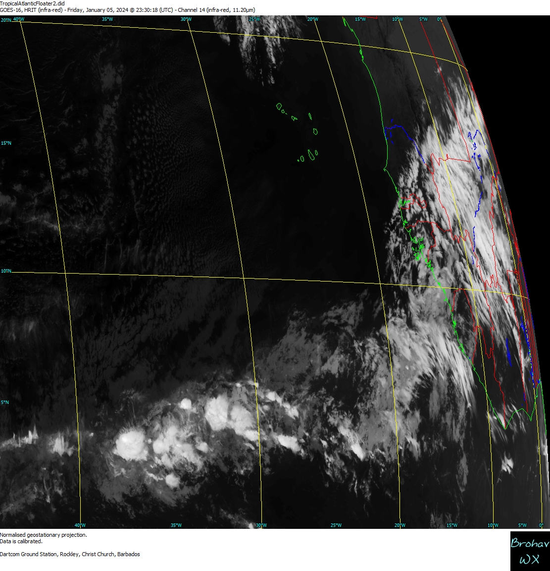
Consolidation of heavier convection - though small in area - and definite rotation can be seen especially in the last few loops ... Saharan dust is evident to its north.

1 likes
-
floridasun78
- Category 5

- Posts: 3755
- Joined: Sun May 17, 2009 10:16 pm
- Location: miami fl
Re: ATL: INVEST 95L - Discussion
i remember we seen ts in that area late july but not early july if not mistaking
0 likes
-
brohavwx
- Tropical Depression
- Posts: 74
- Age: 62
- Joined: Thu Jun 21, 2018 7:16 pm
- Location: Barbados
- Contact:
Re: ATL: INVEST 95L - Models
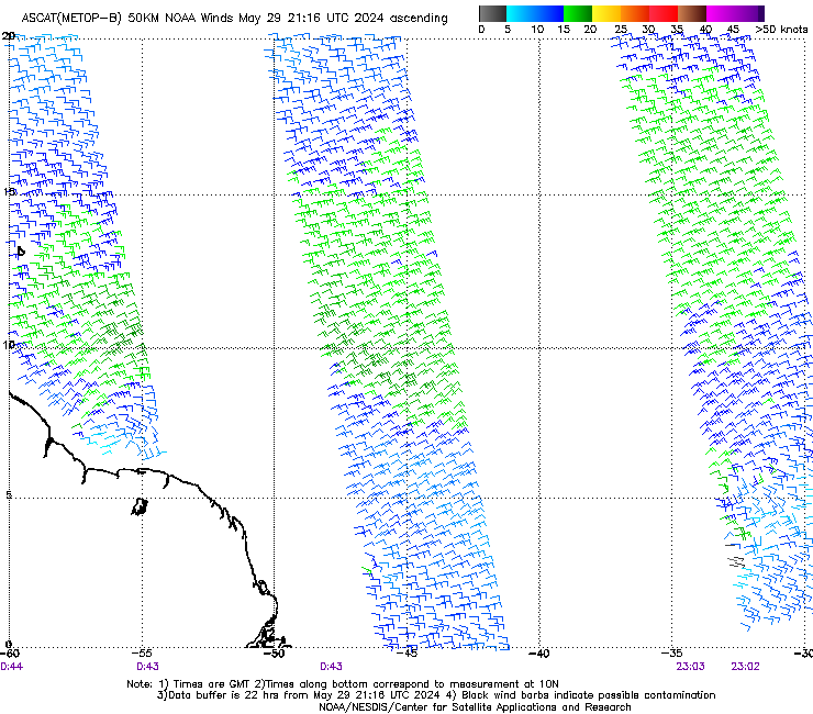
Latest ASCAT-MetopB pass at around 23:00 UTC (or 7:00 pm local time) shows something starting to happen at the surface between 30-35W just south of 10N ...
0 likes
Re: ATL: INVEST 95L - Discussion
floridasun78 wrote:i remember we seen ts in that area late july but not early july if not mistaking
Yeah, florida, late July is more conducive. However, surprisingly there have been 4 in late June-early July TSs that formed near there or east of there since 1851. One of these was hurricane Bertha, which formed near 10N, 35W on 7/5 in 1996. Of course, 1996 wasn't an oncoming El Nino like 2018 appears to be.
There have been 8 that formed west of 50W to the Lesser Antilles July 1-10.
Last edited by LarryWx on Wed Jul 04, 2018 7:18 am, edited 1 time in total.
0 likes
Personal Forecast Disclaimer:
The posts in this forum are NOT official forecasts and should not be used as such. They are just the opinion of the poster and may or may not be backed by sound meteorological data. They are NOT endorsed by any professional institution or storm2k.org. For official information, please refer to the NHC and NWS products.
The posts in this forum are NOT official forecasts and should not be used as such. They are just the opinion of the poster and may or may not be backed by sound meteorological data. They are NOT endorsed by any professional institution or storm2k.org. For official information, please refer to the NHC and NWS products.
-
NotSparta
- Professional-Met
- Posts: 1649
- Age: 22
- Joined: Fri Aug 18, 2017 8:24 am
- Location: Naples, FL
- Contact:
Re: ATL: INVEST 95L - Models
brohavwx wrote:Latest ASCAT-MetopB pass at around 23:00 UTC (or 7:00 pm local time) shows something starting to happen at the surface between 30-35W just south of 10N ...
[img]https://manati.star.nesdis.noaa.gov/ascat_images/cur_50km_METB/zooms/WMBas26.png[img]
The thread to post this is here http://www.storm2k.org/phpbb2/viewtopic.php?f=59&t=119666
this thread is for model runs, just pointing you in the right direction
0 likes
This post was probably an opinion of mine, and in no way is official. Please refer to http://www.hurricanes.gov for official tropical analysis and advisories.
My website, with lots of tropical wx graphics, including satellite and recon: http://cyclonicwx.com
My website, with lots of tropical wx graphics, including satellite and recon: http://cyclonicwx.com
-
NotSparta
- Professional-Met
- Posts: 1649
- Age: 22
- Joined: Fri Aug 18, 2017 8:24 am
- Location: Naples, FL
- Contact:
Re: ATL: INVEST 95L - Discussion
A concentrated area of showers and thunderstorms associated with
tropical wave and a small area of low pressure is located several
hundred miles southwest of the Cabo Verde Islands. Although
satellite images show some signs of organization, the disturbance
is moving west-northwestward toward an area unfavorable for tropical
cyclone formation.
* Formation chance through 48 hours...low...20 percent.
* Formation chance through 5 days...low...20 percent.
0 likes
This post was probably an opinion of mine, and in no way is official. Please refer to http://www.hurricanes.gov for official tropical analysis and advisories.
My website, with lots of tropical wx graphics, including satellite and recon: http://cyclonicwx.com
My website, with lots of tropical wx graphics, including satellite and recon: http://cyclonicwx.com
-
HurricaneRyan
- Category 2

- Posts: 712
- Age: 30
- Joined: Sun Dec 05, 2010 3:05 pm
-
cycloneye
- Admin
- Posts: 139145
- Age: 67
- Joined: Thu Oct 10, 2002 10:54 am
- Location: San Juan, Puerto Rico
Re: ATL: INVEST 95L - Discussion
Is moving westnorthwest and that will be it's demise as it moves torwards the dry air (SAL) and detachs from ITCZ.

0 likes
Visit the Caribbean-Central America Weather Thread where you can find at first post web cams,radars
and observations from Caribbean basin members Click Here
and observations from Caribbean basin members Click Here
-
Gustywind

- Category 5
- Posts: 12334
- Joined: Mon Sep 03, 2007 7:29 am
- Location: Baie-Mahault, GUADELOUPE
Re: ATL: INVEST 95L - Discussion
000
AXNT20 KNHC 040510
TWDAT
Tropical Weather Discussion
NWS National Hurricane Center Miami FL
110 AM EDT Wed Jul 4 2018
...TROPICAL WAVES...
A vigorous tropical wave is producing a concentrated area of
showers and thunderstorms several hundred miles southwest of the
Cabo Verde Islands. As of 0000 UTC, this tropical wave is
relocated farther E, and now extends from 16N31W to 04N32W. A 1010
mb low pressure has developed along the wave's axis near 09N32W.
Although satellite images show some signs of organization, the
disturbance is moving west-northwestward toward an area unfavorable
for tropical cyclone formation. Currently, the Tropical Weather
Outlook gives this system a low change of development through 48
hours.
0 likes

Re: ATL: INVEST 95L - Discussion
I have been seeing some very heavy MCS activity in West Africa over the last couple weeks.
Couple of them even strengthened over water.
SAL still pretty high though.
Couple of them even strengthened over water.
SAL still pretty high though.
0 likes
Who is online
Users browsing this forum: No registered users and 37 guests