WPAC: HECTOR - Post-Tropical

Moderator: S2k Moderators

Message
Author
User avatar
Cunxi Huang
Category 1
Category 1
Posts: 323
Age: 25
Joined: Thu Sep 26, 2013 12:17 pm
Location: San Luis Obispo, CA

Re: CPAC: HECTOR - Hurricane

#861 Postby Cunxi Huang » Fri Aug 10, 2018 3:27 pm

Image

WMG.
5 likes   
2006 SuTY SAOMAI | 2009 TY LINFA | 2010 TY FANAPI | 2010 SuTY MEGI | 2016 SuTY MERANTI | 2019 SuTY LEKIMA
DO NOT use my posts for life and death decisions. For official information, please refer to products from your RSMC and national weather agency.

User avatar
1900hurricane
Category 5
Category 5
Posts: 6044
Age: 32
Joined: Fri Feb 06, 2015 12:04 pm
Location: Houston, TX
Contact:

Re: CPAC: HECTOR - Hurricane

#862 Postby 1900hurricane » Fri Aug 10, 2018 4:22 pm

Still hanging out around that 6.0 DT, even with the eye warming to warm medium grey due to the CDO warming, although it isn't far off from 6.5.
1 likes   
Contract Meteorologist. TAMU & MSST. Fiercely authentic, one of a kind. We are all given free will, so choose a life meant to be lived. We are the Masters of our own Stories.
Opinions expressed are mine alone.

Follow me on Twitter at @1900hurricane : Read blogs at https://1900hurricane.wordpress.com/

Sciencerocks
Category 5
Category 5
Posts: 7282
Age: 38
Joined: Thu Jul 06, 2017 1:51 am

Re: CPAC: HECTOR - Hurricane

#863 Postby Sciencerocks » Fri Aug 10, 2018 5:27 pm

I think for a brief time earlier in its life near the time of the first recon that it was probably a cat5. IMO
7 likes   

User avatar
xtyphooncyclonex
Category 5
Category 5
Posts: 3688
Age: 22
Joined: Sat Dec 08, 2012 9:07 am
Location: Cebu City
Contact:

Re: CPAC: HECTOR - Hurricane

#864 Postby xtyphooncyclonex » Fri Aug 10, 2018 8:07 pm

Impressive. Hector has now accrued 41.8 units of ACE as of 10/2100Z, and has been a major hurricane of 7 days and counting.

http://tropical.atmos.colostate.edu/Rea ... astpacific
0 likes   
REMINDER: My opinions that I, or any other NON Pro-Met in this forum, are unofficial. Please do not take my opinions as an official forecast and warning. I am NOT a meteorologist. Following my forecasts blindly may lead to false alarm, danger and risk if official forecasts from agencies are ignored.

Sciencerocks
Category 5
Category 5
Posts: 7282
Age: 38
Joined: Thu Jul 06, 2017 1:51 am

Re: CPAC: HECTOR - Hurricane

#865 Postby Sciencerocks » Sat Aug 11, 2018 1:16 am

Philip Klotzbach
‏Verified account @philklotzbach
3h3 hours ago

#Hector has now been a major #hurricane for 7.25 consecutive days - the most consecutive days as a major hurricane for any storm in the Northeast Pacific (to 180°) on record. Old record was Norbert (1984) at 7 consecutive days as a major hurricane.
0 likes   

Sciencerocks
Category 5
Category 5
Posts: 7282
Age: 38
Joined: Thu Jul 06, 2017 1:51 am

Re: CPAC: HECTOR - Hurricane

#866 Postby Sciencerocks » Sat Aug 11, 2018 1:27 am

Image
1 likes   

Ntxw
Storm2k Moderator
Storm2k Moderator
Posts: 21495
Joined: Wed Oct 21, 2009 6:34 pm
Location: DFW, Texas

Re: CPAC: HECTOR - Hurricane

#867 Postby Ntxw » Sat Aug 11, 2018 12:26 pm

Hector has definitely hit a wall of shear and it shows

Image
2 likes   
The above post and any post by Ntxw is NOT an official forecast and should not be used as such. It is just the opinion of the poster and may or may not be backed by sound meteorological data. It is NOT endorsed by any professional institution including Storm2k. For official information, please refer to NWS products.

  Help support Storm2K!
Help Support Storm2K

User avatar
Cunxi Huang
Category 1
Category 1
Posts: 323
Age: 25
Joined: Thu Sep 26, 2013 12:17 pm
Location: San Luis Obispo, CA

Re: CPAC: HECTOR - Hurricane

#868 Postby Cunxi Huang » Sat Aug 11, 2018 2:10 pm

Image

:eek: :eek: :eek:
0 likes   
2006 SuTY SAOMAI | 2009 TY LINFA | 2010 TY FANAPI | 2010 SuTY MEGI | 2016 SuTY MERANTI | 2019 SuTY LEKIMA
DO NOT use my posts for life and death decisions. For official information, please refer to products from your RSMC and national weather agency.

Twisted-core
Category 1
Category 1
Posts: 252
Joined: Fri May 11, 2018 9:20 pm

Re: CPAC: HECTOR - Hurricane

#869 Postby Twisted-core » Sat Aug 11, 2018 4:52 pm

1 likes   

User avatar
1900hurricane
Category 5
Category 5
Posts: 6044
Age: 32
Joined: Fri Feb 06, 2015 12:04 pm
Location: Houston, TX
Contact:

Re: CPAC: HECTOR - Hurricane

#870 Postby 1900hurricane » Sat Aug 11, 2018 9:02 pm

Really starting to take a beating now.

Image
4 likes   
Contract Meteorologist. TAMU & MSST. Fiercely authentic, one of a kind. We are all given free will, so choose a life meant to be lived. We are the Masters of our own Stories.
Opinions expressed are mine alone.

Follow me on Twitter at @1900hurricane : Read blogs at https://1900hurricane.wordpress.com/

Twisted-core
Category 1
Category 1
Posts: 252
Joined: Fri May 11, 2018 9:20 pm

Re: CPAC: HECTOR - Hurricane

#871 Postby Twisted-core » Sat Aug 11, 2018 9:32 pm

1 likes   

User avatar
storm_in_a_teacup
Category 1
Category 1
Posts: 348
Joined: Wed Aug 16, 2017 5:01 pm
Location: Huntsville, Alabama
Contact:

Re: CPAC: HECTOR - Hurricane

#872 Postby storm_in_a_teacup » Sat Aug 11, 2018 11:52 pm

2 likes   
I know I can't straddle the atmosphere...just a tiny storm in your teacup, girl.

User avatar
Cyclenall
Category 5
Category 5
Posts: 6627
Joined: Thu Jun 08, 2006 10:01 pm
Location: Ontario, Canada

Re: CPAC: HECTOR - Hurricane

#873 Postby Cyclenall » Sun Aug 12, 2018 1:53 am

storm_in_a_teacup wrote:That last image looks really brutal. :cry:

Its getting even worse in the last 4 frames. I'm impressed its getting sheared apart that quick; the windshear must be over 50 knots. Is Hector even going to make it to the Wpac at all? The Euro was correct once again in freefall weakening and the vector. Hector is not the promised hurricane - a sustainable low-rider where art thou?

Ntxw wrote:Hector has definitely hit a wall of shear and it shows

*image*

Perfect example why you need a hurricane moving due westwards at 10N or lower to be truly legend. As soon as the Euro showed the TRASH outcome 5-6 days ago that was the beginning of the end. For heaven's sakes Hector, you didn't lose some latitude and now look at the results! :oops: The great Hawaiian Shear Belt is real.
5 likes   

User avatar
storm_in_a_teacup
Category 1
Category 1
Posts: 348
Joined: Wed Aug 16, 2017 5:01 pm
Location: Huntsville, Alabama
Contact:

Re: CPAC: HECTOR - Hurricane

#874 Postby storm_in_a_teacup » Sun Aug 12, 2018 3:03 am

Cyclenall wrote:
storm_in_a_teacup wrote:That last image looks really brutal. :cry:

Its getting even worse in the last 4 frames. I'm impressed its getting sheared apart that quick; the windshear must be over 50 knots. Is Hector even going to make it to the Wpac at all? The Euro was correct once again in freefall weakening and the vector. Hector is not the promised hurricane - a sustainable low-rider where art thou?

Ntxw wrote:Hector has definitely hit a wall of shear and it shows

*image*

Perfect example why you need a hurricane moving due westwards at 10N or lower to be truly legend. As soon as the Euro showed the TRASH outcome 5-6 days ago that was the beginning of the end. For heaven's sakes Hector, you didn't lose some latitude and now look at the results! :oops: The great Hawaiian Shear Belt is real.


The Hawaiian Shear Belt is a thing? What causes it?
0 likes   
I know I can't straddle the atmosphere...just a tiny storm in your teacup, girl.

Twisted-core
Category 1
Category 1
Posts: 252
Joined: Fri May 11, 2018 9:20 pm

Re: CPAC: HECTOR - Hurricane

#875 Postby Twisted-core » Sun Aug 12, 2018 3:58 am

Mid-latitude westerlies.
0 likes   

User avatar
wxman57
Moderator-Pro Met
Moderator-Pro Met
Posts: 22480
Age: 66
Joined: Sat Jun 21, 2003 8:06 pm
Location: Houston, TX (southwest)

Re: CPAC: HECTOR - Hurricane

#876 Postby wxman57 » Sun Aug 12, 2018 7:17 am

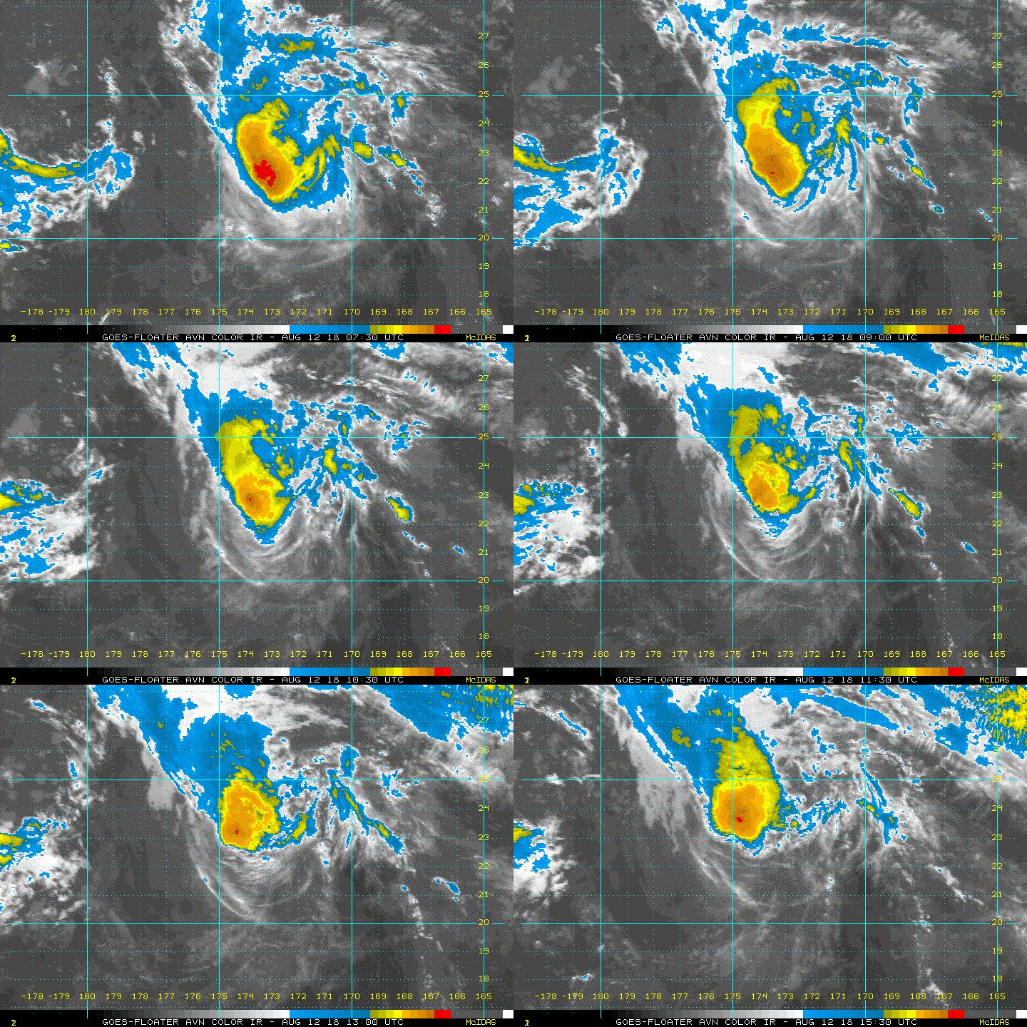
Hector appeared to lose its eye around 18Z yesterday. I don't know how the CPHC is still calling this a hurricane.
3 likes   

User avatar
euro6208
Category 5
Category 5
Posts: 18547
Joined: Mon Mar 08, 2004 7:50 pm
Location: Guam

Re: CPAC: HECTOR - Hurricane

#877 Postby euro6208 » Sun Aug 12, 2018 7:22 am

Nice to say that it might get upgraded postseason to a Cat 5 but no evidence. I say it fail. Besides the Hawaii threat and the expected crossover, it's nothing...
0 likes   
Remember, all of my post aren't official. For official warnings and discussions, Please refer to your local NWS products...

NWS for the Western Pacific

https://www.weather.gov/gum/

User avatar
Ptarmigan
Category 5
Category 5
Posts: 5272
Joined: Wed Aug 16, 2006 9:06 pm

Re: CPAC: HECTOR - Hurricane

#878 Postby Ptarmigan » Sun Aug 12, 2018 10:26 am

Hurricane Hector has the most consecutive days as a major hurricane in the Northeast Pacific.
https://en.wikipedia.org/wiki/Hurricane_Hector_(2018)
2 likes   

User avatar
mrbagyo
Category 5
Category 5
Posts: 3614
Age: 31
Joined: Thu Apr 12, 2012 9:18 am
Location: 14.13N 120.98E
Contact:

Re: CPAC: HECTOR - Hurricane

#879 Postby mrbagyo » Sun Aug 12, 2018 10:59 am

Image
Whut? It's still a cane???

10E HECTOR 180812 1200 22.4N 173.6W EPAC 75 984
2 likes   
The posts in this forum are NOT official forecast and should not be used as such. They are just the opinion of the poster and may or may not be backed by sound meteorological data. They are NOT endorsed by any professional institution or storm2k.org. For official information, please refer to RSMC, NHC and NWS products.

User avatar
cycloneye
Admin
Admin
Posts: 139029
Age: 67
Joined: Thu Oct 10, 2002 10:54 am
Location: San Juan, Puerto Rico

Re: CPAC: HECTOR - Hurricane

#880 Postby cycloneye » Sun Aug 12, 2018 11:11 am

Hurricane Hector Discussion Number 49
NWS Central Pacific Hurricane Center Honolulu HI EP102018
500 AM HST Sun Aug 12 2018

Hector continues to rapidly weaken this morning due to 20 to 30
knots of south-southwesterly shear over the system as analyzed by
the latest UW-CIMSS shear analysis. The low level circulation
center remains difficult to locate, but a couple overnight microwave
passes and an ASCAT pass were helpful in determining the center
location. The latest subjective Dvorak intensity estimates were 4.5
(77 knots) from PHFO, 4.0 (65 knots) from SAB, and 3.5 (55 knots)
from JTWC. Meanwhile, the Advanced Dvorak Technique from UW-CIMSS
was 4.4 (75 knots). The satellite presentation clearly shows that
weakening is ongoing, but given the persistent deep convection over
the low level circulation center and necessary spin down time needed
as these systems weaken, will only lower the initial intensity to 75
knots with this advisory which is on the higher side of the
intensity estimates. The initial motion is set at 305/14 knots.

The latest model guidance remains tightly clustered through 96
hours, with the spread in the track guidance increasing
considerably by 120 hours. Hector is expected to continue on a
northwest track today on the eastern periphery of an upper level low
to the west of the International Date Line. The system is expected
to make a turn to a more westerly direction tonight and continue on
this course through Wednesday as an upper level ridge builds north
of the system. A turn toward the northwest and eventually north is
then expected Wednesday night through Friday as Hector rounds the
southwest periphery of the upper level ridge. The new official
forecast track is very close to the consensus guidance as well as
the track from the previous advisory.

The intensity forecast calls for steady weakening of Hector over
the next 12 to 24 hours as the system will be in a hostile
environment under 15 to 30 knots of southwesterly shear. The shear
is forecast to decrease beyond 24 hours, but the system will likely
have weakened considerably by this time and will be moving over
marginal sea surface temperatures between 79 and 81 degrees
Fahrenheit. The intensity guidance is in fairly good agreement
through 36 hours, so confidence during this portion of the forecast
is fairly good. There is quite a bit of spread in the intensity
guidance beyond 36 hours however, with the HWRF and CTCI models
continuing to show Hector re-intensifying into a hurricane by 48
hours and holding at hurricane strength through 120 hours. This
seems really aggressive given the state the hurricane is in at the
moment and with the continued weakening forecast. As a result, the
official intensity forecast calls for steady weakening through
tonight, with Hector becoming a Tropical Storm later today or
tonight. Beyond 24 hours the forecast intensity has been held
steady, with weakening expected at the end of the forecast period as
Hector transitions over to an extratropical system.

Probabilities for tropical storm force winds reaching the
Northwestern Hawaiian Islands have decreased since the previous
advisory. If Hector continues to weaken as expected, and the
forecast track of a northwest to west-northwest motion holds true,
the Tropical Storm Watches currently in effect from Lisianski
Island to Pearl and Hermes Atoll, as well as for Midway and Kure
Atolls, may be cancelled later today.


FORECAST POSITIONS AND MAX WINDS

INIT 12/1500Z 22.8N 174.2W 75 KT 85 MPH
12H 13/0000Z 24.0N 176.2W 65 KT 75 MPH
24H 13/1200Z 25.3N 179.0W 55 KT 65 MPH
36H 14/0000Z 26.3N 178.0E 55 KT 65 MPH
48H 14/1200Z 27.2N 174.9E 55 KT 65 MPH
72H 15/1200Z 29.3N 168.4E 55 KT 65 MPH
96H 16/1200Z 32.1N 163.4E 55 KT 65 MPH
120H 17/1200Z 36.1N 161.3E 45 KT 50 MPH...POST-TROP/EXTRATROP

$$
Forecaster Jelsema
0 likes   
Visit the Caribbean-Central America Weather Thread where you can find at first post web cams,radars
and observations from Caribbean basin members Click Here


Return to “2018”

Who is online

Users browsing this forum: No registered users and 9 guests