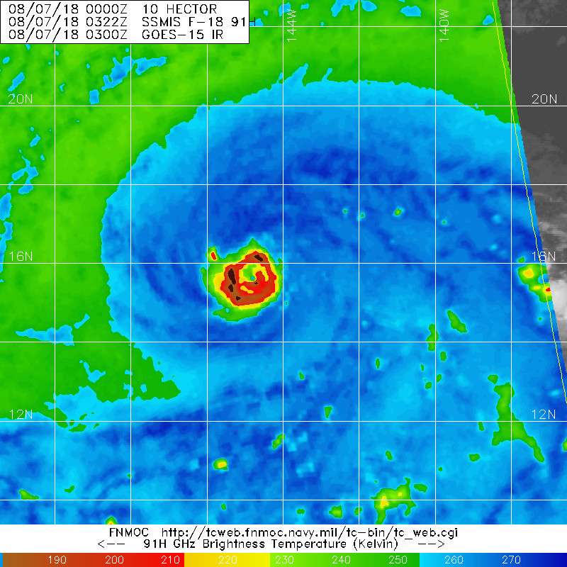
WPAC: HECTOR - Post-Tropical

Moderator: S2k Moderators

Message
Author
User avatar
Yellow Evan
Professional-Met
Professional-Met
Posts: 15951
Age: 25
Joined: Fri Jul 15, 2011 12:48 pm
Location: Henderson, Nevada/Honolulu, HI
Contact:

Re: CPAC: HECTOR - Hurricane

#721 Postby Yellow Evan » Mon Aug 06, 2018 10:51 pm

404UserNotFound wrote:Now imagine if Hector had crossed over from the Atlantic.

(...Is a crossover into the Indian Ocean too much to ask for?)


Highly likely it gets picked up by a trough before then.
0 likes   

User avatar
storm_in_a_teacup
Category 1
Category 1
Posts: 348
Joined: Wed Aug 16, 2017 5:01 pm
Location: Huntsville, Alabama
Contact:

Re: CPAC: HECTOR - Hurricane

#722 Postby storm_in_a_teacup » Mon Aug 06, 2018 10:53 pm

Dylan wrote:
NDG wrote:What is interesting is that Hector has been able to become such a strong Cat 4 hurricane tracking over SSTs only near 26.5-27C telling us that surface waters don't have to be that warm as long as there's perfect atmospheric conditions and the atmosphere is not too warm.


Yeah, but it’s not surprising at all that it’s gone annular, since the majority of hurricanes develop annular characteristics in strictly 25-28C waters. I don’t see any reason why Hector would see any significant fluctuations in intensity over the next several days.

I also suspect that models are underestimating the mid-level ridge to the north, since Hectors outflow will likely enhance it, similar to Irma last year. You can only write equations for so many things that a model can handle.


Okay something that has been bothering me about the whole “annular” thing:
People say annular hurricanes are more stable in marginal conditions than the average hurricane, but if they typically are found in the self-same marginal conditions, are they annular before entering those conditions, and they survive for longer because of that; or are the marginal conditions actually causing the annular state?

...also hi. It’s been a while.
Last edited by storm_in_a_teacup on Mon Aug 06, 2018 11:21 pm, edited 1 time in total.
2 likes   
I know I can't straddle the atmosphere...just a tiny storm in your teacup, girl.

User avatar
Cyclenall
Category 5
Category 5
Posts: 6627
Joined: Thu Jun 08, 2006 10:01 pm
Location: Ontario, Canada

Re: CPAC: HECTOR - Hurricane

#723 Postby Cyclenall » Mon Aug 06, 2018 11:21 pm

404UserNotFound wrote:Now imagine if Hector had crossed over from the Atlantic.

(...Is a crossover into the Indian Ocean too much to ask for?)

I was actually going to joke about the Indian Ocean thing. That would be the best case scenario for making the most out of this hurricane. Something I thought of years back was how rare it would be to have a tropical cyclone navigate across nearly the entire earth where there is ocean available, missing every trough and staying westwards at a very low latitude. Start off the west coast of Africa and then end up at the east coast of said continent. I think from a physics perspective its doable however assuming landmass was exactly the same it would occur once in our earth's entire existence. With our current geography, once in 4.5 billion years.

Eric Webb wrote:*Awesome Write-up Removed*

Here's the link to the study on Environmental Humidity and TC size from one of my professors at NCSU (Gary Lackmann)
https://journals.ametsoc.org/doi/abs/10.1175/2009MWR2679.1

I saved that paragraph about what's conducive to annular hurricanes, that was gold.
2 likes   

User avatar
Dylan
Professional-Met
Professional-Met
Posts: 337
Age: 29
Joined: Mon May 31, 2010 9:50 am
Location: New Orleans, LA

Re: CPAC: HECTOR - Hurricane

#724 Postby Dylan » Mon Aug 06, 2018 11:29 pm

storm_in_a_teacup wrote:
Dylan wrote:
NDG wrote:What is interesting is that Hector has been able to become such a strong Cat 4 hurricane tracking over SSTs only near 26.5-27C telling us that surface waters don't have to be that warm as long as there's perfect atmospheric conditions and the atmosphere is not too warm.


Yeah, but it’s not surprising at all that it’s gone annular, since the majority of hurricanes develop annular characteristics in strictly 25-28C waters. I don’t see any reason why Hector would see any significant fluctuations in intensity over the next several days.

I also suspect that models are underestimating the mid-level ridge to the north, since Hectors outflow will likely enhance it, similar to Irma last year. You can only write equations for so many things that a model can handle.


Okay something that has been bothering me about the whole “annular” thing:
People say annular hurricanes are more stable in marginal conditions than the average hurricane, but if they typically are found in the self-same marginal conditions, are they annular before entering those conditions, and the survive for longer because of that; or are the marginal conditions actually causing the annular state?

...also hi. It’s been a while


No they aren’t annular before they develop annular characteristics. That’s ridiculous. Hurricanes generally develop annular characteristics in a specific environment, which is SST’s between 25-28C, light easterly upper level winds, and an anomalously cold temperatures in the upper troposphere. Conditions have to be just right, and that’s why they’re extremely rare.

My assumption is that the hurricane gains the annular structure as an adjustment to most efficiently operate its latent heat engine in that specific environment.
1 likes   
Georges('98), Allison('01), Isidore('02), Lili('02), Frances('04) Ivan('04), Cindy('05), Katrina('05), Rita('05), Gustav('08), Isaac('12), Matthew('16), Harvey('17), Irma('17), Nate ('17), Ida ('21).

Chris90
Category 2
Category 2
Posts: 637
Age: 34
Joined: Thu Jun 01, 2017 9:36 pm

Re: CPAC: HECTOR - Hurricane

#725 Postby Chris90 » Mon Aug 06, 2018 11:41 pm

Kingarabian wrote:Look like a possible EWRC starting.


Based off microwave images from the past several hours, it seems like Hector may possibly be pulling off one of those "eyewall melds" that Irma was famous for last year. I remember she pulled off one of those eyewall melding situations close to her peak right before Barbuda landfall, and she was also displaying some annular characteristics with some really great symmetry.

Maybe the more symmetric the CDO of a hurricane is, the more efficient it is at pulling off an EWRC?
4 likes   
Solar Aquarian
Lunar Cancerian
:uarrow: Sagittarian

User avatar
Yellow Evan
Professional-Met
Professional-Met
Posts: 15951
Age: 25
Joined: Fri Jul 15, 2011 12:48 pm
Location: Henderson, Nevada/Honolulu, HI
Contact:

Re: CPAC: HECTOR - Hurricane

#726 Postby Yellow Evan » Tue Aug 07, 2018 1:16 am

000
WTPA31 PHFO 070548
TCPCP1

BULLETIN
Hurricane Hector Intermediate Advisory Number 27A
NWS Central Pacific Hurricane Center Honolulu HI EP102018
800 PM HST Mon Aug 06 2018

...STRONG CATEGORY FOUR HURRICANE HECTOR CONTINUES TO MOVE
WESTWARD ACROSS THE CENTRAL PACIFIC...


SUMMARY OF 800 PM HST...0600 UTC...INFORMATION
----------------------------------------------
LOCATION...15.8N 145.6W
ABOUT 680 MI...1095 KM ESE OF HILO HAWAII
ABOUT 895 MI...1440 KM ESE OF HONOLULU HAWAII
MAXIMUM SUSTAINED WINDS...155 MPH...250 KM/H
PRESENT MOVEMENT...WNW OR 285 DEGREES AT 16 MPH...26 KM/H
MINIMUM CENTRAL PRESSURE...936 MB...27.64 INCHES


WATCHES AND WARNINGS
--------------------
CHANGES WITH THIS ADVISORY:

None.

SUMMARY OF WATCHES AND WARNINGS IN EFFECT:

A Tropical Storm Watch is in effect for...
* Hawaii County

A Tropical Storm Watch means that tropical storm conditions are
possible within the watch area within 48 hours.

Interests elsewhere in the Hawaiian Islands should monitor the
progress of Hector.

For storm information specific to your area, please monitor
products issued by the National Weather Service office in
Honolulu Hawaii.


DISCUSSION AND OUTLOOK
----------------------
At 800 PM HST (0600 UTC), the center of Hurricane Hector was located
near latitude 15.8 North, longitude 145.6 West. Hector is moving
toward the west-northwest near 16 mph (26 km/h). This motion is
expected to continue tonight, followed by a turn toward the west on
Tuesday and Wednesday. On the forecast track, Hector is expected to
pass roughly 150 miles south of the Big Island of Hawaii on
Wednesday.

Maximum sustained winds are near 155 mph (250 km/h) with higher
gusts. Hector is a category 4 hurricane on the Saffir-Simpson
Hurricane Wind Scale. Some weakening is forecast during the next 48
hours, though Hector is expected to remain a major hurricane.

Hurricane-force winds extend outward up to 35 miles (55 km) from
the center and tropical-storm-force winds extend outward up to 105
miles (165 km).

The estimated minimum central pressure is 936 mb (27.64 inches).


HAZARDS AFFECTING LAND
----------------------
SURF: Swells generated by Hector are expected to reach southeast
and east facing shores of the Big Island and eastern Maui during
the next day, likely becoming large by late Tuesday and Wednesday.

WIND: Tropical storm force winds are possible across Hawaii
County late Tuesday night or Wednesday.


NEXT ADVISORY
-------------
Next complete advisory at 1100 PM HST.

$$
Forecaster Jelsema
0 likes   

User avatar
Yellow Evan
Professional-Met
Professional-Met
Posts: 15951
Age: 25
Joined: Fri Jul 15, 2011 12:48 pm
Location: Henderson, Nevada/Honolulu, HI
Contact:

Re: EPAC: HECTOR - Recon

#727 Postby Yellow Evan » Tue Aug 07, 2018 1:23 am

We're having problems again....

140
URPN15 KNHC 070616
AF309 0410E HECTOR HDOB 20 20180807
052800 1751N 14820W 4099 07433 0423 -133 -443 078034 034 /// /// 03
052830 1751N 14818W 4099 07433 0423 -132 -442 079034 034 /// /// 03
052900 1750N 14816W 4099 07432 0422 -131 -441 079034 034 /// /// 03
052930 1749N 14813W 4099 07432 0422 -132 -443 080034 034 /// /// 03
053000 1748N 14811W 4099 07430 0422 -130 -445 080033 034 /// /// 03
053030 1747N 14809W 4098 07433 0421 -130 -447 079033 033 /// /// 03
053100 1746N 14807W 4098 07433 0422 -130 -450 079033 034 /// /// 03
053130 1745N 14805W 4099 07430 0421 -130 -452 079034 034 /// /// 03
053200 1744N 14802W 4099 07432 0421 -128 -454 079034 034 /// /// 03
053230 1744N 14800W 4099 07429 0420 -130 -454 079035 035 /// /// 03
053300 1743N 14758W 4099 07429 0419 -130 -454 078035 035 /// /// 03
053330 1742N 14756W 4099 07429 0419 -128 -454 079036 038 /// /// 03
053400 1741N 14754W 4098 07430 0418 -130 -454 079037 038 /// /// 03
053430 1740N 14752W 4098 07428 0417 -135 -451 076038 038 /// /// 03
053500 1739N 14749W 4099 07426 0417 -135 -449 074039 039 /// /// 03
053530 1738N 14747W 4099 07426 0415 -138 -445 075043 045 /// /// 03
053600 1737N 14745W 4098 07426 0414 -140 -436 075045 045 /// /// 03
053630 1737N 14743W 4098 07426 0413 -140 -428 073044 045 /// /// 03
053700 1736N 14741W 4099 07421 0412 -140 -424 072044 045 /// /// 03
053730 1735N 14739W 4098 07422 0411 -140 -423 071045 045 /// /// 03
$$
2 likes   

User avatar
NotSparta
Professional-Met
Professional-Met
Posts: 1645
Age: 22
Joined: Fri Aug 18, 2017 8:24 am
Location: Naples, FL
Contact:

Re: CPAC: HECTOR - Hurricane

#728 Postby NotSparta » Tue Aug 07, 2018 1:23 am

Recon is headed in, seem to be some communication problems though
0 likes   
This post was probably an opinion of mine, and in no way is official. Please refer to http://www.hurricanes.gov for official tropical analysis and advisories.

My website, with lots of tropical wx graphics, including satellite and recon: http://cyclonicwx.com

User avatar
Yellow Evan
Professional-Met
Professional-Met
Posts: 15951
Age: 25
Joined: Fri Jul 15, 2011 12:48 pm
Location: Henderson, Nevada/Honolulu, HI
Contact:

Re: EPAC: HECTOR - Recon

#729 Postby Yellow Evan » Tue Aug 07, 2018 1:39 am

061800 1603N 14545W 6969 03067 9961 +093 +019 068089 090 059 006 00
061830 1602N 14544W 6971 03054 9954 +090 +033 068092 094 066 006 00
061900 1601N 14543W 6969 03046 9943 +089 +034 069097 098 066 006 00
061930 1600N 14543W 6971 03032 9921 +096 +029 067100 101 068 008 00
062000 1559N 14542W 6967 03025 9908 +093 +049 068096 103 074 024 00
062030 1558N 14541W 6987 02986 9896 +089 +066 073088 088 079 009 00
062100 1557N 14540W 6967 02998 9858 +110 +054 074091 092 085 002 00
062130 1556N 14539W 6969 02978 9824 +122 +045 075097 100 087 000 03
062200 1554N 14539W 6970 02955 9800 +121 +040 076104 107 /// /// 03
062230 1553N 14538W 6955 02931 9755 +125 +023 078115 116 092 000 03
062300 1551N 14538W 6977 02863 9708 +123 +045 073115 116 099 000 03
062330 1549N 14538W 6967 02814 9624 +141 +059 073117 119 104 000 03
062400 1548N 14538W 6978 02736 9547 +154 +063 069107 116 /// /// 03
062430 1546N 14537W 6975 02695 9509 +136 +076 068081 100 096 001 03
062500 1544N 14537W 6969 02665 9475 +128 +084 068058 070 072 001 00
062530 1543N 14536W 6977 02626 9429 +148 +066 073042 052 050 001 00
062600 1541N 14535W 6970 02616 9399 +160 +058 074018 033 033 003 03
062630 1540N 14535W 6983 02599 9420 +137 +078 228004 008 026 001 00
062700 1538N 14535W 6987 02609 9437 +136 +078 282028 041 039 003 00
062730 1536N 14536W 6974 02668 9493 +124 +080 278059 066 050 003 03
0 likes   

User avatar
Yellow Evan
Professional-Met
Professional-Met
Posts: 15951
Age: 25
Joined: Fri Jul 15, 2011 12:48 pm
Location: Henderson, Nevada/Honolulu, HI
Contact:

Re: EPAC: HECTOR - Recon

#730 Postby Yellow Evan » Tue Aug 07, 2018 2:07 am

004
URPN15 KNHC 070658
AF309 0410E HECTOR HDOB 28 20180807
064800 1446N 14443W 6970 03158 0065 +092 +044 207030 032 025 000 00
064830 1445N 14442W 6969 03162 0066 +095 +038 209028 029 025 000 00
064900 1444N 14441W 6970 03162 0070 +094 +009 207026 027 024 000 00
064930 1443N 14439W 6973 03161 0072 +094 +010 200027 027 023 000 00
065000 1441N 14438W 6967 03167 0064 +100 -001 199028 028 022 000 00
065030 1440N 14437W 6968 03165 0068 +098 +005 204030 030 024 001 00
065100 1439N 14435W 6970 03164 0073 +093 +014 209028 030 024 001 00
065130 1438N 14434W 6970 03168 0077 +092 +022 209024 027 024 001 00
065200 1437N 14433W 6970 03170 0078 +094 +018 207023 024 022 001 00
065230 1436N 14431W 6970 03169 0076 +095 +003 204023 023 020 001 00
065300 1435N 14430W 6970 03172 0076 +097 -007 203023 023 019 000 00
065330 1433N 14429W 6970 03164 0069 +099 -007 204023 023 018 000 00
065400 1432N 14428W 6971 03163 0067 +100 -007 203021 022 017 000 00
065430 1431N 14426W 6969 03170 0070 +100 -010 203021 021 019 000 00
065500 1430N 14425W 6973 03163 0066 +100 -010 202020 021 020 000 00
065530 1429N 14424W 6969 03169 0073 +100 -010 204021 021 019 000 00
065600 1428N 14422W 6971 03173 0076 +100 -004 205020 020 019 000 00
065630 1426N 14421W 6969 03175 0076 +100 +002 204020 021 019 000 00
065700 1426N 14421W 6969 03175 0073 +100 +000 203020 021 018 000 00
065730 1424N 14418W 6970 03172 0075 +099 +000 200020 021 017 000 00
$$
0 likes   

User avatar
mrbagyo
Category 5
Category 5
Posts: 3614
Age: 31
Joined: Thu Apr 12, 2012 9:18 am
Location: 14.13N 120.98E
Contact:

Re: CPAC: HECTOR - Hurricane

#731 Postby mrbagyo » Tue Aug 07, 2018 2:44 am

Yeah, this appears to be a melding type ERC


Image
Southern sector have already merged
1 likes   
The posts in this forum are NOT official forecast and should not be used as such. They are just the opinion of the poster and may or may not be backed by sound meteorological data. They are NOT endorsed by any professional institution or storm2k.org. For official information, please refer to RSMC, NHC and NWS products.

User avatar
Kingarabian
S2K Supporter
S2K Supporter
Posts: 15433
Joined: Sat Aug 08, 2009 3:06 am
Location: Honolulu, Hawaii

Re: CPAC: HECTOR - Hurricane

#732 Postby Kingarabian » Tue Aug 07, 2018 2:48 am

mrbagyo wrote:Yeah, this appears to be a melding type ERC


[img]https://imageshack.com/a/img924/6484/iX9OUf.jpg[img]
Southern sector have already merged


What's astounding is that the eye remains in tact and very warm. Usually the eye would be cooling and filling in. Very odd.
0 likes   
RIP Kobe Bryant

User avatar
Kingarabian
S2K Supporter
S2K Supporter
Posts: 15433
Joined: Sat Aug 08, 2009 3:06 am
Location: Honolulu, Hawaii

Re: EPAC: HECTOR - Recon

#733 Postby Kingarabian » Tue Aug 07, 2018 2:53 am

Data transmission continues to be corrupted:

Image
0 likes   
RIP Kobe Bryant

User avatar
Cyclenall
Category 5
Category 5
Posts: 6627
Joined: Thu Jun 08, 2006 10:01 pm
Location: Ontario, Canada

Re: CPAC: HECTOR - Hurricane

#734 Postby Cyclenall » Tue Aug 07, 2018 2:54 am

Yesterday (and now into this morning) was a bad day in the tropics from a scientific curiosity perspective. Don't get me wrong, I had fun following some of the zany nonsense the Pacific had to offer. Also read some brilliant content/perspective from here. Recon didn't last long or capture precious data at a critical time for Hector, John turned into mush and appears as if he got flung down a mine shaft at 20z, Ileana is pretty much a rainband of John, some of the model guidance is showing an abysmal long range for Hector that should kill any interest that is present with the 135 knot beast, Hector in recent hours gaining too much latitude, and more.

The latest Euro isn't as bad as the 12z run for Hector but I still don't like it too much. The high really needs to build in there and Hector needs to take a dip sw when near the dateline. I don't think I need to mention the recon problems, now that really burns!
1 likes   

User avatar
Kingarabian
S2K Supporter
S2K Supporter
Posts: 15433
Joined: Sat Aug 08, 2009 3:06 am
Location: Honolulu, Hawaii

Re: CPAC: HECTOR - Hurricane

#735 Postby Kingarabian » Tue Aug 07, 2018 2:58 am

Cyclenall wrote:Yesterday (and now into this morning) was a bad day in the tropics from a scientific curiosity perspective. Don't get me wrong, I had fun following some of the zany nonsense the Pacific had to offer. Also read some brilliant content/perspective from here. Recon didn't last long or capture precious data at a critical time for Hector, John turned into mush and appears as if he got flung down a mine shaft at 20z, Ileana is pretty much a rainband of John, some of the model guidance is showing an abysmal long range for Hector that should kill any interest that is present with the 135 knot beast, Hector in recent hours gaining too much latitude, and more.

The latest Euro isn't as bad as the 12z run for Hector but I still don't like it too much. The high really needs to build in there and Hector needs to take a dip sw when near the dateline. I don't think I need to mention the recon problems, now that really burns!


Hate to say it, but if Hector's current EWRC wraps in too much dry air, it'll likely drop down to Cat.3. If that's the case then recon robbed us of a category 5 classification. But their safety first of course.
1 likes   
RIP Kobe Bryant

User avatar
Ubuntwo
Category 5
Category 5
Posts: 1089
Age: 30
Joined: Thu Oct 05, 2017 10:41 pm

Re: CPAC: HECTOR - Hurricane

#736 Postby Ubuntwo » Tue Aug 07, 2018 3:00 am

Kingarabian wrote:
mrbagyo wrote:Yeah, this appears to be a melding type ERC


[img]https://imageshack.com/a/img924/6484/iX9OUf.jpg[img]
Southern sector have already merged


What's astounding is that the eye remains in tact and very warm. Usually the eye would be cooling and filling in. Very odd.


Reminiscent of Irma's ERCs where intensity remained constant throughout.
1 likes   
Kendall -> SLO -> PBC

Memorable Storms: Katrina (for its Florida landfall...) Wilma Matthew Irma

User avatar
xtyphooncyclonex
Category 5
Category 5
Posts: 3688
Age: 22
Joined: Sat Dec 08, 2012 9:07 am
Location: Cebu City
Contact:

Re: CPAC: HECTOR - Hurricane

#737 Postby xtyphooncyclonex » Tue Aug 07, 2018 3:04 am

Cyclenall wrote:Yesterday (and now into this morning) was a bad day in the tropics from a scientific curiosity perspective. Don't get me wrong, I had fun following some of the zany nonsense the Pacific had to offer. Also read some brilliant content/perspective from here. Recon didn't last long or capture precious data at a critical time for Hector, John turned into mush and appears as if he got flung down a mine shaft at 20z, Ileana is pretty much a rainband of John, some of the model guidance is showing an abysmal long range for Hector that should kill any interest that is present with the 135 knot beast, Hector in recent hours gaining too much latitude, and more.

The latest Euro isn't as bad as the 12z run for Hector but I still don't like it too much. The high really needs to build in there and Hector needs to take a dip sw when near the dateline. I don't think I need to mention the recon problems, now that really burns!

Hector is actually following the forecasts, and remains to be stronger than expected.
2 likes   
REMINDER: My opinions that I, or any other NON Pro-Met in this forum, are unofficial. Please do not take my opinions as an official forecast and warning. I am NOT a meteorologist. Following my forecasts blindly may lead to false alarm, danger and risk if official forecasts from agencies are ignored.

User avatar
Kingarabian
S2K Supporter
S2K Supporter
Posts: 15433
Joined: Sat Aug 08, 2009 3:06 am
Location: Honolulu, Hawaii

Re: CPAC: HECTOR - Hurricane

#738 Postby Kingarabian » Tue Aug 07, 2018 3:52 am

Looks like it's beginning to intensify again based on the latest Dvorak frames:

Image

Recon info is still spotty, but last pass looked like its down to 125kts-130kts and 945mb.
0 likes   
RIP Kobe Bryant

User avatar
Kingarabian
S2K Supporter
S2K Supporter
Posts: 15433
Joined: Sat Aug 08, 2009 3:06 am
Location: Honolulu, Hawaii

Re: EPAC: HECTOR - Recon

#739 Postby Kingarabian » Tue Aug 07, 2018 4:00 am

No recon info since HDOB 34:

966
URPN15 KNHC 070801
AF309 0410E HECTOR HDOB 34 20180807
074800 1640N 14501W 6966 03180 0078 +100 +014 120046 046 025 001 00
074830 1639N 14502W 6966 03179 0074 +102 +011 118046 047 026 000 00
074900 1638N 14503W 6967 03175 0073 +102 +013 118048 048 026 000 00
074930 1637N 14505W 6965 03178 0070 +103 +008 118047 049 027 001 00
075000 1635N 14506W 6970 03171 0072 +100 +011 116050 051 029 000 00
075030 1634N 14507W 6965 03177 0071 +101 +014 112050 051 026 000 00
075100 1632N 14509W 6969 03172 0073 +099 +012 114050 050 026 001 00
075130 1631N 14510W 6967 03172 0074 +095 +012 114049 049 027 000 00
075200 1630N 14512W 6969 03169 0078 +091 +019 116052 052 028 000 00
075230 1628N 14513W 6967 03168 0077 +091 +022 114051 052 028 000 00
075300 1627N 14514W 6971 03162 0076 +090 +029 117051 051 030 000 00
075330 1626N 14516W 6966 03167 0075 +090 +021 119050 051 032 000 00
075400 1624N 14517W 6967 03165 0069 +091 +019 120050 051 031 000 00
075430 1623N 14519W 6969 03160 0071 +090 +025 122052 052 033 000 00
075500 1622N 14520W 6968 03158 0069 +087 +045 126054 054 033 001 00
075530 1621N 14521W 6965 03160 0069 +084 +053 128054 055 036 001 00
075600 1619N 14523W 6971 03150 0061 +090 +046 131056 057 036 002 00
075630 1618N 14524W 6967 03152 0056 +091 +029 131058 059 037 001 00
075700 1617N 14525W 6969 03149 0050 +095 +025 129060 061 041 002 00
075730 1616N 14526W 6965 03151 0043 +099 +025 126061 061 041 001 00
$$
;
0 likes   
RIP Kobe Bryant

Eric Webb
Tropical Storm
Tropical Storm
Posts: 154
Joined: Fri Mar 13, 2015 10:42 pm
Contact:

Re: CPAC: HECTOR - Hurricane

#740 Postby Eric Webb » Tue Aug 07, 2018 7:12 am

Kingarabian wrote:
mrbagyo wrote:Yeah, this appears to be a melding type ERC


[img]https://imageshack.com/a/img924/6484/iX9OUf.jpg[img]
Southern sector have already merged


What's astounding is that the eye remains in tact and very warm. Usually the eye would be cooling and filling in. Very odd.


That’s actually what’s happening now, you may have spoke too soon, ERCs take several hours at the very least, occasionally an entire day may be needed to suffice.
0 likes   


Return to “2018”

Who is online

Users browsing this forum: No registered users and 81 guests