
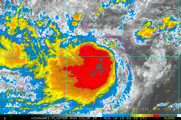
TXPQ22 KNES 150953
TCSWNP
A. 20W (BEBINCA)
B. 15/0830Z
C. 21.1N
D. 111.4E
E. THREE/HIMAWARI-8
F. T3.0/3.5/W0.5/06HRS
G. IR/EIR/VIS
H. REMARKS...THIS INTENSITY ESTIMATE WAS DERIVED USING 4 KM IR DATA. WELL
DEFINED CDO MEASURING 1.25 DEG RESULTS IN A DT OF 3.0. MET IS 3.5 AND
PT IS 3.0. FT IS BASED ON DT.
I. ADDL POSITIONS
NIL
...RAMIREZ
WPAC: BEBINCA - Post-Tropical
Moderator: S2k Moderators
Re: WPAC: BEBINCA - Tropical Storm
0 likes
Remember, all of my post aren't official. For official warnings and discussions, Please refer to your local NWS products...
NWS for the Western Pacific
https://www.weather.gov/gum/
NWS for the Western Pacific
https://www.weather.gov/gum/
Re: WPAC: BEBINCA - Tropical Storm

0 likes
Remember, all of my post aren't official. For official warnings and discussions, Please refer to your local NWS products...
NWS for the Western Pacific
https://www.weather.gov/gum/
NWS for the Western Pacific
https://www.weather.gov/gum/
-
mrbagyo

- Category 5

- Posts: 3614
- Age: 31
- Joined: Thu Apr 12, 2012 9:18 am
- Location: 14.13N 120.98E
- Contact:
Re: WPAC: BEBINCA - Tropical Storm

JTWC @ 35 knots
JMA @ 40 knots
0 likes
The posts in this forum are NOT official forecast and should not be used as such. They are just the opinion of the poster and may or may not be backed by sound meteorological data. They are NOT endorsed by any professional institution or storm2k.org. For official information, please refer to RSMC, NHC and NWS products.
Re: WPAC: BEBINCA - Tropical Storm
Clearly stronger than what the agencies think.
0 likes
Remember, all of my post aren't official. For official warnings and discussions, Please refer to your local NWS products...
NWS for the Western Pacific
https://www.weather.gov/gum/
NWS for the Western Pacific
https://www.weather.gov/gum/
-
mrbagyo
- Category 5
- Posts: 3614
- Age: 31
- Joined: Thu Apr 12, 2012 9:18 am
- Location: 14.13N 120.98E
- Contact:
Re: WPAC: BEBINCA - Tropical Storm
All members are above 40 knots
CURRENT ESTIMATE
Date (mmddhhmm): 08151834
SATCON: MSLP = 986 hPa MSW = 49 knots
SATCON Member Consensus: 48.0 knots
Pressure -> Wind Using SATCON MSLP: 51 knots
Distance to Outer Closed Isobar Used is 210 nm
Eye Size Correction Used is 0 knots Source: NA
Member Estimates
ADT: 991 hPa 43 knots Scene: CDO Date: AUG152050
CIMSS AMSU: 984 hPa 49 knots Bias Corr: 0 (MW) Date: 08150853
ATMS: 980.1 hPa 53.2 knots Date: 08151834
SSMIS: 980.1 hPa 53.2 knots Date: 08151834
CIRA ATMS: hPa knots Date:
0 likes
The posts in this forum are NOT official forecast and should not be used as such. They are just the opinion of the poster and may or may not be backed by sound meteorological data. They are NOT endorsed by any professional institution or storm2k.org. For official information, please refer to RSMC, NHC and NWS products.
-
mrbagyo
- Category 5
- Posts: 3614
- Age: 31
- Joined: Thu Apr 12, 2012 9:18 am
- Location: 14.13N 120.98E
- Contact:
Re: WPAC: BEBINCA - Tropical Storm
They finally upped the intensity
20W BEBINCA 180816 0000 20.1N 108.5E WPAC 50 988
20W BEBINCA 180816 0000 20.1N 108.5E WPAC 50 988
0 likes
The posts in this forum are NOT official forecast and should not be used as such. They are just the opinion of the poster and may or may not be backed by sound meteorological data. They are NOT endorsed by any professional institution or storm2k.org. For official information, please refer to RSMC, NHC and NWS products.
Re: WPAC: BEBINCA - Tropical Storm

Rapidly developing.
WDPN33 PGTW 152100
MSGID/GENADMIN/JOINT TYPHOON WRNCEN PEARL HARBOR HI//
SUBJ/PROGNOSTIC REASONING FOR TROPICAL STORM 20W (BEBINCA) WARNING
NR 15//
RMKS/
1. FOR METEOROLOGISTS.
2. 6 HOUR SUMMARY AND ANALYSIS.
TROPICAL STORM (TS) 20W (BEBINCA), LOCATED APPROXIMATELY 156 NM
EAST-SOUTHEAST OF HANOI, VIETNAM, HAS TRACKED WEST-SOUTHWESTWARD AT
13 KNOTS OVER THE PAST SIX HOURS. ANIMATED MULTI-SPECTRAL IMAGERY
DEPICTS A COMPACT SYSTEM WHICH IS UNDERGOING A PERIOD OF RAPID
INTENSIFICATION. THE LLLC IS OBSCURED BY A CENTRAL DENSE OVERCAST
HOWEVER, A 160041Z GPM 37 GHZ MICROWAVE IMAGE DEPICTED A CLEAR
MICROWAVE EYE FEATURE, WITH DEEP CONVECTION MOSTLY CONFINED TO THE
WEST AND SOUTHWESTERN QUADRANTS. THE INITIAL POSITION IS PLACED WITH
HIGH CONFIDENCE BASED ON THE MICROWAVE DATA AND SURFACE OBSERVATIONS
FROM THE REGION. THE INITIAL INTENSITY OF 50 KNOTS IS BASED ON A
SUBJECTIVE DVORAK INTENSITY ESTIMATE OF T3.0 (45 KNOTS) FROM PGTW, A
T3.0 AUTOMATED INTENSITY ESTIMATE AND A SATCON ESTIMATE OF 49 KNOTS.
A THREE-HOURLY SYNOPTIC OBSERVATION FROM BACH LONG VI, VIETNAM, AT
THAT TIME APPROXIMATELY 50 NM AHEAD OF THE LLCC, REPORTED 37 KNOTS
AND A PRESSURE OF 995 MB, CONFIRMING THE OVERALL PLACEMENT AND
INTENSITY ASSESSMENTS. ENVIRONMENTAL ANALYSIS INDICATES THAT THE
OVERALL ENVIRONMENT HAS REMAINED STAGNANT SINCE THE PREVIOUS
FORECAST, WITH MODERATE (20-25 KNOTS) VWS, STRONG WESTWARD DIVERGENT
OUTFLOW AND VERY WARM SSTS (31 DEG C). TS 20W CONTINUES TO TRACK
WEST-SOUTHWESTWARD UNDER THE INFLUENCE OF A DEEP STR LOCATED OVER
CENTRAL CHINA.
3. FORECAST REASONING.
A. THERE IS NO CHANGE TO THE FORECAST PHILOSOPHY FROM THE PREVIOUS
PROGNOSTIC REASONING MESSAGE, OTHER THAN TO INCREASE THE INTENSITY
PRIOR TO LANDFALL.
B. TS 20W IS FORECAST TO CONTINUE TO TRACK WEST-SOUTHWESTWARD
THROUGH TAU 12, UNDER THE INFLUENCE OF THE STRONG STR ANCHORED OVER
CENTRAL CHINA, BEFORE TURNING MORE WESTWARD AND MAKING LANDFALL IN
NORTHERN VIETNAM JUST BEFORE TAU 24. TS 20W HAS UNDERGONE A PERIOD
OF RAPID INTENSIFICATION IN THE GULF OF TONKIN AND IS FORECAST TO
CONTINUE TO INTENSIFY SLIGHTLY OVER THE NEXT 24 HOURS PRIOR TO
LANDFALL. PEAK INTENSITY OF 60 KNOTS IS EXPECTED JUST PRIOR TO
LANDFALL, AS THE SYSTEM TRACKS WESTWARD UNDER FAVORABLE
ENVIRONMENTAL CONDITIONS. AFTER MAKING LANDFALL, TS 20W WILL TRACK
INTO NORTHERN LAOS BY TAU 48, WHILE RAPIDLY DISSIPATING DUE TO
INTERACTION WITH THE MOUNTAINOUS TERRAIN. NUMERICAL MODEL GUIDANCE
IS IN MUCH BETTER AGREEMENT THAN THE PREVIOUS FORECAST, WITH ALL
MODELS EXCEPT HWRF IN AGREEMENT ON THE OVERALL TRACK SCENARIO. HWRF
CONTINUES TO TRACK THE SYSTEM DUE SOUTH, LOOP BACK TO THE WEST AND
THEN NORTH BACK OVER THE LEIZHOU PENINSULA. THIS SCENARIO IS HIGHLY
UNLIKELY BASED ON THE OVERALL SYNOPTIC PATTERN, AND IS THEREFORE
DISCOUNTED. WITH THE INCREASED AGREEMENT IN THE MODELS, THERE IS
HIGH CONFIDENCE IN THE JTWC FORECAST TRACK.//
NNNN
0 likes
Remember, all of my post aren't official. For official warnings and discussions, Please refer to your local NWS products...
NWS for the Western Pacific
https://www.weather.gov/gum/
NWS for the Western Pacific
https://www.weather.gov/gum/
Re: WPAC: BEBINCA - Tropical Storm
TXPQ22 KNES 160342
TCSWNP
A. 20W (BEBINCA)
B. 16/0230Z
C. 20.1N
D. 108.4E
E. THREE/HIMAWARI-8
F. T4.0/4.0/D0.5/24HRS
G. IR/EIR/VIS
H. REMARKS...THIS INTENSITY ESTIMATE WAS DERIVED USING 4 KM IR DATA. EYE
FEATURE CAN BE SEEN IN BOTH THE 2354Z SSMIS AND 0041Z GMI PASSES. DT OF
3.5 IS BASED ON 1.5 WD CDO. MET AND PT ARE 4.0. FT IS BASED ON MET.
I. ADDL POSITIONS
NIL
...RAMIREZ
0 likes
Remember, all of my post aren't official. For official warnings and discussions, Please refer to your local NWS products...
NWS for the Western Pacific
https://www.weather.gov/gum/
NWS for the Western Pacific
https://www.weather.gov/gum/
Re: WPAC: BEBINCA - Tropical Storm
TPPN12 PGTW 160340
A. TROPICAL STORM 20W (BEBINCA)
B. 16/0300Z
C. 20.09N
D. 108.22E
E. FIVE/HMWRI8
F. T3.5/3.5/D1.0/24HRS STT: D0.5/03HRS
G. IR/EIR/VIS/MSI
H. REMARKS: 44A/PBO LARGE CDO/ANMTN. 120NM CDO PLUS 0.5 BF
YIELDS DT OF 3.5. MET/PT AGREE. DBO DT.
I. ADDITIONAL POSITIONS:
15/2254Z 20.32N 108.73E WIND
15/2354Z 20.12N 108.45E SSMS
16/0041Z 20.08N 108.52E GPMI
ZOUFALY
0 likes
Remember, all of my post aren't official. For official warnings and discussions, Please refer to your local NWS products...
NWS for the Western Pacific
https://www.weather.gov/gum/
NWS for the Western Pacific
https://www.weather.gov/gum/
Re: WPAC: BEBINCA - Tropical Storm
Any radars from the area?
0 likes
Remember, all of my post aren't official. For official warnings and discussions, Please refer to your local NWS products...
NWS for the Western Pacific
https://www.weather.gov/gum/
NWS for the Western Pacific
https://www.weather.gov/gum/
-
mrbagyo
- Category 5
- Posts: 3614
- Age: 31
- Joined: Thu Apr 12, 2012 9:18 am
- Location: 14.13N 120.98E
- Contact:
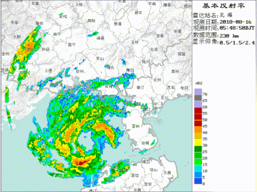
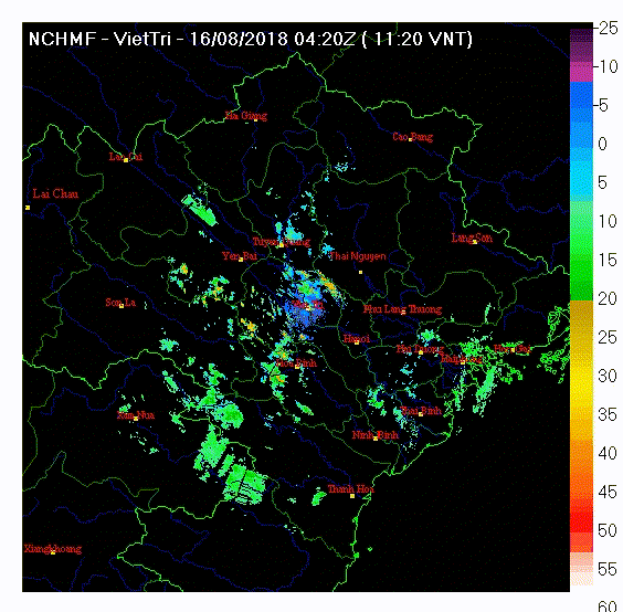
Re: WPAC: BEBINCA - Tropical Storm
euro6208 wrote:Any radars from the area?
Vietnam has - however its radar webpage is just pain in the ass to access (Hit or Miss).
VietTri Radar
Last edited by mrbagyo on Fri Aug 17, 2018 12:00 am, edited 1 time in total.
0 likes
The posts in this forum are NOT official forecast and should not be used as such. They are just the opinion of the poster and may or may not be backed by sound meteorological data. They are NOT endorsed by any professional institution or storm2k.org. For official information, please refer to RSMC, NHC and NWS products.
-
mrbagyo
- Category 5
- Posts: 3614
- Age: 31
- Joined: Thu Apr 12, 2012 9:18 am
- Location: 14.13N 120.98E
- Contact:
Re: WPAC: BEBINCA - Tropical Storm
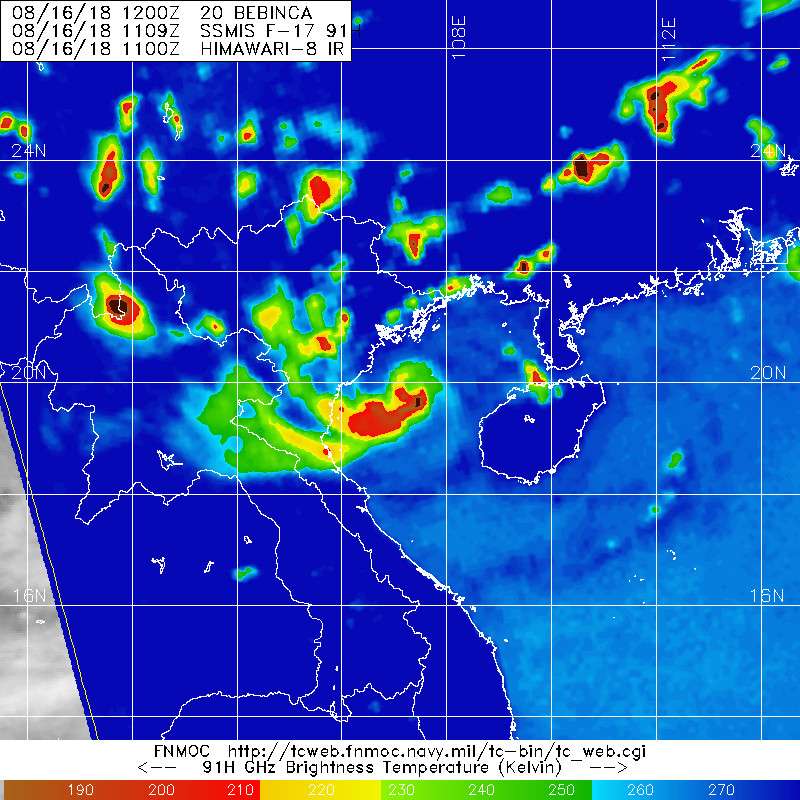
Bebinca is set to become a typhoon before landfall.
Hint of an eye is now starting to appear in visible imagery.
Hint of an eye is now starting to appear in visible imagery.
0 likes
The posts in this forum are NOT official forecast and should not be used as such. They are just the opinion of the poster and may or may not be backed by sound meteorological data. They are NOT endorsed by any professional institution or storm2k.org. For official information, please refer to RSMC, NHC and NWS products.
-
mrbagyo
- Category 5
- Posts: 3614
- Age: 31
- Joined: Thu Apr 12, 2012 9:18 am
- Location: 14.13N 120.98E
- Contact:
Re: WPAC: BEBINCA - Tropical Storm
55 knots
20W BEBINCA 180816 0600 20.1N 107.6E WPAC 55 982
20W BEBINCA 180816 0600 20.1N 107.6E WPAC 55 982
0 likes
The posts in this forum are NOT official forecast and should not be used as such. They are just the opinion of the poster and may or may not be backed by sound meteorological data. They are NOT endorsed by any professional institution or storm2k.org. For official information, please refer to RSMC, NHC and NWS products.
-
mrbagyo
- Category 5
- Posts: 3614
- Age: 31
- Joined: Thu Apr 12, 2012 9:18 am
- Location: 14.13N 120.98E
- Contact:
Re: WPAC: BEBINCA - Tropical Storm

0 likes
The posts in this forum are NOT official forecast and should not be used as such. They are just the opinion of the poster and may or may not be backed by sound meteorological data. They are NOT endorsed by any professional institution or storm2k.org. For official information, please refer to RSMC, NHC and NWS products.
Re: WPAC: BEBINCA - Tropical Storm

WDPN33 PGTW 160900
MSGID/GENADMIN/JOINT TYPHOON WRNCEN PEARL HARBOR HI//
SUBJ/PROGNOSTIC REASONING FOR TROPICAL STORM 20W (BEBINCA) WARNING
NR 16//
RMKS/
1. FOR METEOROLOGISTS.
2. 6 HOUR SUMMARY AND ANALYSIS.
TROPICAL STORM (TS) 20W (BEBINCA), LOCATED APPROXIMATELY 110 NM
EAST-SOUTHEAST OF HANOI, VIETNAM, HAS TRACKED WESTWARD AT 10 KNOTS
OVER THE PAST SIX HOURS. ANIMATED MULTISPECTRAL SATELLITE IMAGERY
DEPICTS A RAPIDLY-CONSOLIDATING, COMPACT SYSTEM WITH TIGHTLY-CURVED
BANDING WRAPPING INTO A DEFINED CENTER. A 160223Z MHS 89GHZ IMAGE
SHOWS TIGHTLY-CURVED BANDING OVER THE SOUTHERN SEMICIRCLE WITH A
WELL-DEFINED LOW-LEVEL CIRCULATION CENTER. CONSEQUENTLY, THERE IS
GOOD CONFIDENCE IN THE INITIAL POSITION. TS 20W APPEARS TO HAVE
TRACKED DIRECTLY OVER BACH LONG VI (48839), WHICH REPORTED SURFACE
WINDS AT 16/03Z OF 340/47 KNOTS AND SLP 990.6MB (16/06Z OBSERVATIONS
WERE NOT AVAILABLE). THE INITIAL INTENSITY IS ASSESSED AT 55 KNOTS
BASED ON THE BACH LONG VI SURFACE OBSERVATION PLUS DVORAK INTENSITY
ESTIMATES RANGING FROM T3.5 (55 KNOTS) TO T4.0 (65 KNOTS). UPPER-
LEVEL ANALYSIS REVEALS A MARGINALLY-FAVORABLE ENVIRONMENT WITH
MODERATE TO STRONG VERTICAL WIND SHEAR OFFSET BY STRONG DIFFLUENCE.
TS 20W IS TRACKING WESTWARD ALONG THE SOUTHERN PERIPHERY OF THE LOW-
TO MID-LEVEL SUBTROPICAL RIDGE (STR) POSITIONED TO THE NORTH.
3. FORECAST REASONING.
A. THERE IS NO CHANGE TO THE FORECAST PHILOSOPHY FROM THE PREVIOUS
PROGNOSTIC REASONING MESSAGE.
B. TS 20W WILL CONTINUE TRACKING WESTWARD THROUGH THE FORECAST
PERIOD AND IS EXPECTED TO MAKE LANDFALL NEAR TAU 12. SLIGHT
INTENSIFICATION IS EXPECTED WITH A PEAK OF 60 KNOTS JUST PRIOR TO
LANDFALL. AFTER TAU 12, THE SYSTEM WILL TRACK INLAND AND WEAKEN
RAPIDLY AS IT INTERACTS WITH THE MOUNTAINOUS REGION OF VIETNAM AND
LAOS. TS 20W WILL DISSIPATE BY TAU 36. NUMERICAL GUIDANCE REMAINS IN
GOOD AGREEMENT, THEREFORE, THERE IS HIGH CONFIDENCE IN THE JTWC
FORECAST TRACK.//
NNNN
0 likes
Remember, all of my post aren't official. For official warnings and discussions, Please refer to your local NWS products...
NWS for the Western Pacific
https://www.weather.gov/gum/
NWS for the Western Pacific
https://www.weather.gov/gum/
Re: WPAC: BEBINCA - Tropical Storm
Another underestimated storm...
CIMSS TROPICAL CYCLONE INTENSITY CONSENSUS FOR BEBINCA (20W) 2018
CURRENT ESTIMATE
Date (mmddhhmm): 08160635
SATCON: MSLP = 977 hPa MSW = 64 knots
SATCON Member Consensus: 62.0 knots
Pressure -> Wind Using SATCON MSLP: 70 knots
Distance to Outer Closed Isobar Used is 195 nm
Eye Size Correction Used is 4.1 knots Source: MW
Member Estimates
ADT: 973 hPa 67 knots Scene: CDO Date: AUG160840
CIMSS AMSU: 969 hPa 64 knots Bias Corr: 0 (MW) Date: 08152126
ATMS: 978.4 hPa 54.2 knots Date: 08160635
SSMIS: 978.4 hPa 54.2 knots Date: 08160635
CIRA ATMS: hPa knots Date:
0 likes
Remember, all of my post aren't official. For official warnings and discussions, Please refer to your local NWS products...
NWS for the Western Pacific
https://www.weather.gov/gum/
NWS for the Western Pacific
https://www.weather.gov/gum/
Re: WPAC: BEBINCA - Tropical Storm

Should be at least 65 knots...
0 likes
Remember, all of my post aren't official. For official warnings and discussions, Please refer to your local NWS products...
NWS for the Western Pacific
https://www.weather.gov/gum/
NWS for the Western Pacific
https://www.weather.gov/gum/
-
mrbagyo
- Category 5
- Posts: 3614
- Age: 31
- Joined: Thu Apr 12, 2012 9:18 am
- Location: 14.13N 120.98E
- Contact:
Re: WPAC: BEBINCA - Tropical Storm
0 likes
The posts in this forum are NOT official forecast and should not be used as such. They are just the opinion of the poster and may or may not be backed by sound meteorological data. They are NOT endorsed by any professional institution or storm2k.org. For official information, please refer to RSMC, NHC and NWS products.
-
mrbagyo
- Category 5
- Posts: 3614
- Age: 31
- Joined: Thu Apr 12, 2012 9:18 am
- Location: 14.13N 120.98E
- Contact:
Re: WPAC: BEBINCA - Tropical Storm
SATCON number continues to rise
CURRENT ESTIMATE
Date (mmddhhmm): 08161120
SATCON: MSLP = 966 hPa MSW = 73 knots
SATCON Member Consensus: 73.0 knots
Pressure -> Wind Using SATCON MSLP: 73 knots
Distance to Outer Closed Isobar Used is 195 nm
Eye Size Correction Used is 0 knots Source: NA
Member Estimates
ADT: 970 hPa 72 knots Scene: CDO Date: AUG161240
CIMSS AMSU: 957 hPa 78 knots Bias Corr: 0 (MW) Date: 08161120
ATMS: 957.4 hPa 86.4 knots Date: 08160635
SSMIS: 957.4 hPa 86.4 knots Date: 08160635
CIRA ATMS: hPa knots Date
60 knots
20W BEBINCA 180816 1200 20.0N 107.3E WPAC 60 978
0 likes
The posts in this forum are NOT official forecast and should not be used as such. They are just the opinion of the poster and may or may not be backed by sound meteorological data. They are NOT endorsed by any professional institution or storm2k.org. For official information, please refer to RSMC, NHC and NWS products.
Who is online
Users browsing this forum: No registered users and 20 guests