WPAC: JEBI - Post-Tropical
Moderator: S2k Moderators
-
NotoSans
- Category 5

- Posts: 1366
- Age: 24
- Joined: Sun Sep 27, 2015 1:15 am
- Location: Hong Kong
- Contact:
Re: WPAC: JEBI - Typhoon
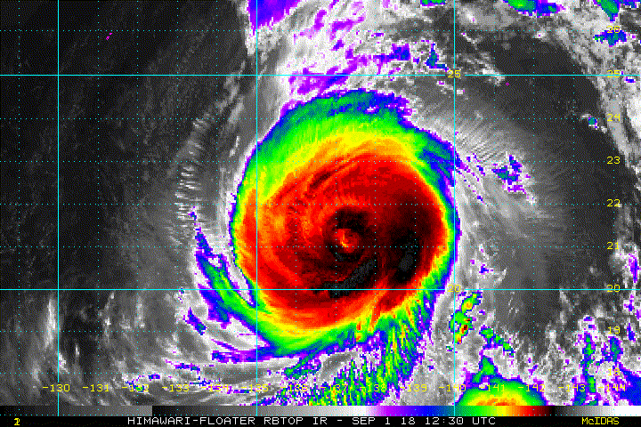
Kinda surprised to see the agencies maintaining such high intensity. Probably down to a low-end category 4 now as JEBI struggles with ERC.
0 likes
Personal Forecast Disclaimer:
The posts in this forum are NOT official forecast and should not be used as such. They are just the opinion of the poster and may or may not be backed by sound meteorological data. They are NOT endorsed by any professional institution or storm2k.org. For official information, please refer to RSMC and NWS products.
The posts in this forum are NOT official forecast and should not be used as such. They are just the opinion of the poster and may or may not be backed by sound meteorological data. They are NOT endorsed by any professional institution or storm2k.org. For official information, please refer to RSMC and NWS products.

Re: WPAC: JEBI - Typhoon

Looks like the last bits of the inner eye wall are eroding.
0 likes
Very useful information on the Dvorak Technique --
https://severe.worldweather.wmo.int/TCF ... kBeven.pdf
https://severe.worldweather.wmo.int/TCF ... kBeven.pdf
-
mrbagyo

- Category 5
- Posts: 3614
- Age: 31
- Joined: Thu Apr 12, 2012 9:18 am
- Location: 14.13N 120.98E
- Contact:
Re: WPAC: JEBI - Typhoon
I think we're about to see something spectacular again in the several hours.
It's pretty close to HWRF
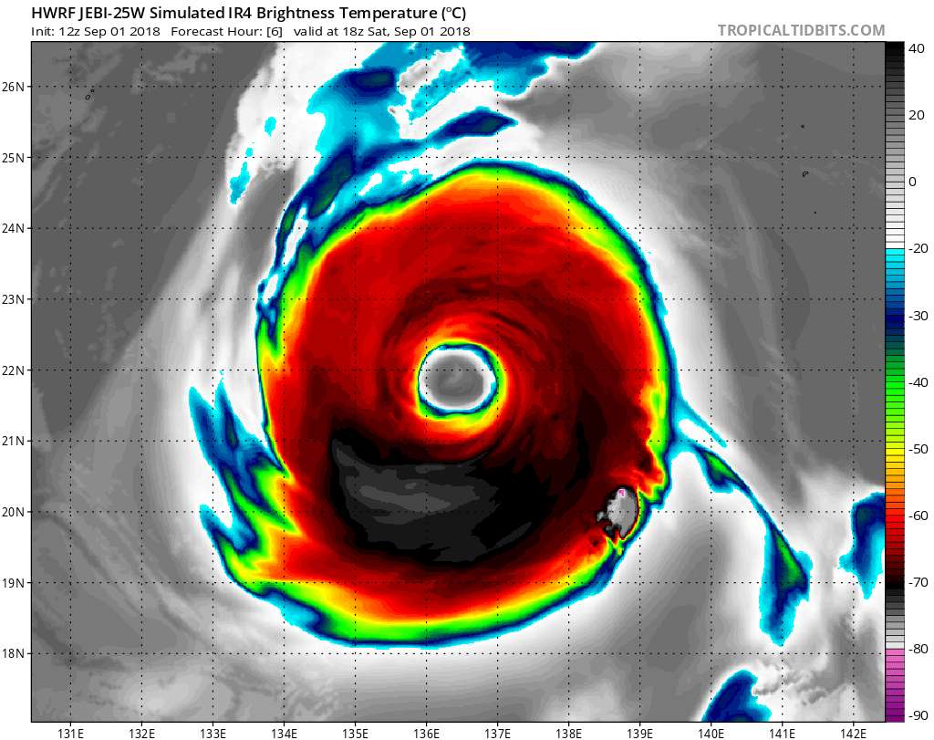
It's pretty close to HWRF
3 likes
The posts in this forum are NOT official forecast and should not be used as such. They are just the opinion of the poster and may or may not be backed by sound meteorological data. They are NOT endorsed by any professional institution or storm2k.org. For official information, please refer to RSMC, NHC and NWS products.
-
ScottNAtlanta

- Category 5
- Posts: 1998
- Joined: Sat May 25, 2013 3:11 pm
- Location: Atlanta, GA
Re: WPAC: JEBI - Typhoon
0 likes
The posts in this forum are NOT official forecast and should not be used as such. They are just the opinion of the poster and may or may not be backed by sound meteorological data. They are NOT endorsed by any professional institution or storm2k.org. For official information, please refer to the NHC and NWS products.
Re: WPAC: JEBI - Typhoon
0 likes
Very useful information on the Dvorak Technique --
https://severe.worldweather.wmo.int/TCF ... kBeven.pdf
https://severe.worldweather.wmo.int/TCF ... kBeven.pdf
Re: WPAC: JEBI - Typhoon
Highteeld wrote:

Huge eye coming soon.
0 likes
Very useful information on the Dvorak Technique --
https://severe.worldweather.wmo.int/TCF ... kBeven.pdf
https://severe.worldweather.wmo.int/TCF ... kBeven.pdf

Re: WPAC: JEBI - Typhoon

WDPN31 PGTW 012100
MSGID/GENADMIN/JOINT TYPHOON WRNCEN PEARL HARBOR HI//
SUBJ/PROGNOSTIC REASONING FOR SUPER TYPHOON 25W (JEBI) WARNING NR
23//
RMKS/
1. FOR METEOROLOGISTS.
2. 6 HOUR SUMMARY AND ANALYSIS.
SUPER TYPHOON (STY) 25W (JEBI), LOCATED APPROXIMATELY 558 NM
EAST-SOUTHEAST OF KADENA AB, OKINAWA, JAPAN, HAS TRACKED
NORTHWESTWARD AT 11 KNOTS OVER THE PAST SIX HOURS. ANIMATED EIR
SATELLITE IMAGERY SHOWS THE SYSTEM CONTINUED TO WEAKEN AS INDICATED
BY WARMING CENTRAL CONVECTION THAT INVARIABLY OBSCURED AN OTHERWISE
WELL-DEFINED EYE. THE INITIAL POSITION IS PLACED WITH HIGH
CONFIDENCE
BASED ON THE EYE FEATURE IN THE EIR LOOP THAT WAS SPOT-ON WITH A
WELL-DEFINED LLC IN THE 011751Z GPM MICROWAVE PASS. THE INITIAL
INTENSITY OF 130 KNOTS IS BASED ON CONGRUENT DVORAK CURRENT INTENSITY
ESTIMATES OF T6.5/127KTS FROM PGTW AND RJTD. STY 25W IS STILL
TRACKING ALONG AN AREA WITH LOW (5-15 KNOT) VWS, GOOD POLEWARD
OUTFLOW, AND WARM (29-30 C) SSTS. HOWEVER, A TUTT TO THE WEST IS
CAUSING SUBSIDENCE AND STIFLED OUTFLOW ALONG THE WESTERN FLANK.
ADDITIONALLY, COLD DRY AIR ENTRAINMENT FROM THE NORTHWEST IS
EVIDENT ON THE EIR LOOP. THE CYCLONE IS TRACKING ALONG THE
SOUTHWESTERN PERIPHERY OF A DEEP-LAYERED STR TO THE NORTH.
3. FORECAST REASONING.
A. THERE IS NO CHANGE TO THE FORECAST PHILOSOPHY FROM THE
PREVIOUS WARNING.
B. STY 25W WILL TURN MORE POLEWARD TOWARD A BREAK IN THE STR. BY
TAU 36, IT WILL CREST THE RIDGE AXIS AND BEFORE TAU 60, THE SYSTEM
WILL MAKE LANDFALL OVER SOUTHERN HONSHU JUST SOUTH OF KYOTO.
AFTERWARD, THE SYSTEM WILL TRACK ACROSS THE JAPANESE ALPS THEN
ACCELERATE NORTH-NORTHEASTWARD IN THE SEA OF JAPAN (SOJ). DIMINISHING
OUTFLOW INDUCED BY THE TUTT CELL AND THE DRY AIR ENTRAINMENT WILL
PROMOTE THE GRADUAL WEAKENING TREND UP TO TAU 48. AFTERWARD, THE
ADDITION OF LAND INTERACTION AND THE COOLER SSTS IN THE SOJ WILL
ERODE THE SYSTEM MORE RAPIDLY AND BY TAU 72, 25W WILL BE REDUCED TO
60 KNOTS AS IT PASSES JUST TO THE WEST OF MISAWA. CONCURRENTLY AT TAU
72, THE SYSTEM WILL BEGIN ETT.
C. AFTER TAU 72, STY JEBI WILL CONTINUE TO ACCELERATE NORTH-
NORTHEASTWARD AND BY TAU 96, WILL BE OVER EASTERN RUSSIA NEAR
SAKHALIN ISLAND AS IT COMPLETES ETT AND BECOME A NEAR GALE-FORCE
COLD-CORE LOW WITH AN EXPANSIVE WIND FIELD. NUMERICAL MODEL GUIDANCE
IS IN TIGHT AGREEMENT UP TO TAU 48, LENDING HIGH CONFIDENCE IN THE
NEAR- TO MID-TERM PORTION OF THE TRACK FORECAST. AFTERWARD, MODEL
FORECASTS SPREAD OUT SIGNIFICANTLY; THIS, PLUS LAND INTERACTION AND
THE VARIANCE IN TRACK SPEEDS, LEND LOW CONFIDENCE IN THE EXTENDED
PORTION OF THE JTWC FORECAST TRACK THAT IS LAID CLOSE TO CONSENSUS.//
NNNN
0 likes
Remember, all of my post aren't official. For official warnings and discussions, Please refer to your local NWS products...
NWS for the Western Pacific
https://www.weather.gov/gum/
NWS for the Western Pacific
https://www.weather.gov/gum/

Re: WPAC: JEBI - Typhoon
I have to say I'm surprised it pulled that ERC off. Jebi is going to look incredible when the eye clears.
1 likes
Re: WPAC: JEBI - Typhoon
aperson wrote:
I have to say I'm surprised it pulled that ERC off. Jebi is going to look incredible when the eye clears.

4 likes
Very useful information on the Dvorak Technique --
https://severe.worldweather.wmo.int/TCF ... kBeven.pdf
https://severe.worldweather.wmo.int/TCF ... kBeven.pdf
-
1900hurricane

- Category 5
- Posts: 6044
- Age: 32
- Joined: Fri Feb 06, 2015 12:04 pm
- Location: Houston, TX
- Contact:
Re: WPAC: JEBI - Typhoon
Latest visible imagery:

0 likes
Contract Meteorologist. TAMU & MSST. Fiercely authentic, one of a kind. We are all given free will, so choose a life meant to be lived. We are the Masters of our own Stories.
Opinions expressed are mine alone.
Follow me on Twitter at @1900hurricane : Read blogs at https://1900hurricane.wordpress.com/
Opinions expressed are mine alone.
Follow me on Twitter at @1900hurricane : Read blogs at https://1900hurricane.wordpress.com/
-
mrbagyo
- Category 5
- Posts: 3614
- Age: 31
- Joined: Thu Apr 12, 2012 9:18 am
- Location: 14.13N 120.98E
- Contact:
Re: WPAC: JEBI - Typhoon

0 likes
The posts in this forum are NOT official forecast and should not be used as such. They are just the opinion of the poster and may or may not be backed by sound meteorological data. They are NOT endorsed by any professional institution or storm2k.org. For official information, please refer to RSMC, NHC and NWS products.
-
xtyphooncyclonex

- Category 5
- Posts: 3688
- Age: 22
- Joined: Sat Dec 08, 2012 9:07 am
- Location: Cebu City
- Contact:
Re: WPAC: JEBI - Typhoon
Down to 115, could go up later today as the eye clears
25W JEBI 180902 0000 22.7N 135.8E WPAC 115 937
25W JEBI 180902 0000 22.7N 135.8E WPAC 115 937
1 likes
REMINDER: My opinions that I, or any other NON Pro-Met in this forum, are unofficial. Please do not take my opinions as an official forecast and warning. I am NOT a meteorologist. Following my forecasts blindly may lead to false alarm, danger and risk if official forecasts from agencies are ignored.
Re: WPAC: JEBI - Typhoon
UW - CIMSS
ADVANCED DVORAK TECHNIQUE
ADT-Version 9.0
Tropical Cyclone Intensity Algorithm
----- Current Analysis -----
Date : 02 SEP 2018 Time : 001000 UTC
Lat : 22:52:12 N Lon : 135:46:12 E
CI# /Pressure/ Vmax
5.6 / 949.5mb/104.6kt
Final T# Adj T# Raw T#
5.6 5.9 5.9
Estimated radius of max. wind based on IR : 9 km
Center Temp : -6.5C Cloud Region Temp : -69.3C
Scene Type : EYE
Subtropical Adjustment : OFF
Extratropical Adjustment : OFF
Positioning Method : ARCHER POSITIONING
Ocean Basin : WEST PACIFIC
Dvorak CI > MSLP Conversion Used : CKZ Method
Tno/CI Rules : Constraint Limits : NO LIMIT
Weakening Flag : OFF
Rapid Dissipation Flag : OFF
C/K/Z MSLP Estimate Inputs :
- Average 34 knot radii : 130nmi
- Environmental MSLP : 1007mb
Satellite Name : HIM-8
Satellite Viewing Angle : 27.3 degrees
****************************************************
0 likes
Remember, all of my post aren't official. For official warnings and discussions, Please refer to your local NWS products...
NWS for the Western Pacific
https://www.weather.gov/gum/
NWS for the Western Pacific
https://www.weather.gov/gum/
-
mrbagyo
- Category 5
- Posts: 3614
- Age: 31
- Joined: Thu Apr 12, 2012 9:18 am
- Location: 14.13N 120.98E
- Contact:
Re: WPAC: JEBI - Typhoon
TY 1821 (Jebi)
Issued at 00:40 UTC, 2 September 2018
<Analysis at 00 UTC, 2 September>
Scale -
Intensity Very strong
Center position N22°30' (22.5°)
E135°50' (135.8°)
Direction and speed of movement NW 20 km/h (10 kt)
Central pressure 935 hPa
Maximum wind speed near center 50 m/s (95 kt)
Maximum wind gust speed 70 m/s (135 kt)
≥ 50 kt wind area ALL 130 km (70 NM)
≥ 30 kt wind area NE 330 km (180 NM)
SW 280 km (150 NM)
0 likes
The posts in this forum are NOT official forecast and should not be used as such. They are just the opinion of the poster and may or may not be backed by sound meteorological data. They are NOT endorsed by any professional institution or storm2k.org. For official information, please refer to RSMC, NHC and NWS products.
-
doomhaMwx

- Category 5
- Posts: 2398
- Age: 25
- Joined: Tue Apr 18, 2017 4:01 am
- Location: Baguio/Benguet, Philippines
- Contact:
-
xtyphooncyclonex
- Category 5
- Posts: 3688
- Age: 22
- Joined: Sat Dec 08, 2012 9:07 am
- Location: Cebu City
- Contact:
Re: WPAC: JEBI - Typhoon
Annular?

0 likes
REMINDER: My opinions that I, or any other NON Pro-Met in this forum, are unofficial. Please do not take my opinions as an official forecast and warning. I am NOT a meteorologist. Following my forecasts blindly may lead to false alarm, danger and risk if official forecasts from agencies are ignored.
Re: WPAC: JEBI - Typhoon
WDPN31 PGTW 020300
MSGID/GENADMIN/JOINT TYPHOON WRNCEN PEARL HARBOR HI//
SUBJ/PROGNOSTIC REASONING FOR TYPHOON 25W (JEBI) WARNING NR 24//
RMKS/
1. FOR METEOROLOGISTS.
2. 6 HOUR SUMMARY AND ANALYSIS.
TYPHOON 25W (JEBI), LOCATED APPROXIMATELY 492 NM EAST-SOUTHEAST
OF KADENA AB, OKINAWA, JAPAN, HAS TRACKED NORTHWESTWARD AT 12 KNOTS
OVER THE PAST SIX HOURS. ANIMATED MSI SHOWS THE SYSTEM CONTINUED TO
DETERIORATE AS INDICATED BY WARMING CENTRAL CONVECTION THAT HAS
INVARIABLY OBSCURED A VERY LARGE, RAGGED, BUT WELL-DEFINED EYE. THE
INITIAL POSITION IS PLACED WITH HIGH CONFIDENCE BASED ON THE EYE
FEATURE IN THE MSI LOOP THAT LINED UP WELL WITH A CLOSED LLC IN THE
012148Z 37 GHZ SSMIS MICROWAVE PASS. THE INITIAL INTENSITY OF 115
KNOTS IS BASED ON CONGRUENT DVORAK CURRENT INTENSITY ESTIMATES OF
T6.0/115KTS FROM PGTW AND RJTD AND REFLECTS THE WEAKENED STATE OF THE
SYSTEM. TY 25W IS STILL TRACKING ALONG AN AREA WITH LOW (5-15 KNOT)
VWS, GOOD POLEWARD OUTFLOW, AND WARM (29-30 C) SSTS. HOWEVER, A TUTT
TO THE WEST IS CAUSING SUBSIDENCE AND STIFLING OUTFLOW ALONG THE
WESTERN FLANK. ADDITIONALLY, COLD DRY AIR ENTRAINMENT FROM THE
NORTHWEST IS EVIDENT ON THE EIR LOOP. THE CYCLONE IS TRACKING ALONG
THE SOUTHWESTERN PERIPHERY OF AN EXTENSION OF THE DEEP-LAYERED STR TO
THE NORTH.
3. FORECAST REASONING.
A. THERE IS NO CHANGE TO THE FORECAST PHILOSOPHY FROM THE PREVIOUS
WARNING.
B. TY JEBI WILL TURN MORE POLEWARD TOWARD A BREAK IN THE STR. BY
TAU 36, IT WILL CREST THE RIDGE AXIS AND BEFORE TAU 54, THE SYSTEM
WILL MAKE LANDFALL OVER SOUTHERN HONSHU JUST SOUTH OF KYOTO.
AFTERWARD, THE SYSTEM WILL TRACK ACROSS THE JAPANESE ALPS THEN
ACCELERATE NORTH-NORTHEASTWARD IN THE SEA OF JAPAN (SOJ). DIMINISHING
OUTFLOW INDUCED BY THE TUTT CELL AND THE DRY AIR ENTRAINMENT WILL
PROMOTE THE GRADUAL WEAKENING TREND UP TO TAU 48. AFTERWARD, THE
ADDITION OF LAND INTERACTION AND THE COOLER SSTS IN THE SOJ WILL
ERODE THE SYSTEM MORE RAPIDLY. CONCURRENTLY BY TAU 48, THE SYSTEM
WILL BEGIN ETT AND BY TAU 72, WILL BECOME A STRONG STORM-FORCE
COLD-CORE LOW WITH AN EXPANSIVE WIND FIELD. NUMERICAL MODEL GUIDANCE
IS IN TIGHT AGREEMENT UP TO TAU 36, LENDING HIGH CONFIDENCE IN THE
NEAR-TERM PORTION OF THE TRACK FORECAST. AFTERWARD, MODEL FORECASTS
SPREAD OUT SIGNIFICANTLY; THIS, PLUS LAND INTERACTION AND THE
VARIANCE IN TRACK SPEEDS, LEND LOW CONFIDENCE IN THE EXTENDED PORTION
OF THE JTWC FORECAST TRACK THAT IS LAID CLOSE TO CONSENSUS.//
NNNN
0 likes
Remember, all of my post aren't official. For official warnings and discussions, Please refer to your local NWS products...
NWS for the Western Pacific
https://www.weather.gov/gum/
NWS for the Western Pacific
https://www.weather.gov/gum/
-
mrbagyo
- Category 5
- Posts: 3614
- Age: 31
- Joined: Thu Apr 12, 2012 9:18 am
- Location: 14.13N 120.98E
- Contact:
Re: WPAC: JEBI - Typhoon
Cat 3
25W JEBI 180902 0600 23.7N 135.0E WPAC 110 943
25W JEBI 180902 0600 23.7N 135.0E WPAC 110 943
0 likes
The posts in this forum are NOT official forecast and should not be used as such. They are just the opinion of the poster and may or may not be backed by sound meteorological data. They are NOT endorsed by any professional institution or storm2k.org. For official information, please refer to RSMC, NHC and NWS products.
-
mrbagyo
- Category 5
- Posts: 3614
- Age: 31
- Joined: Thu Apr 12, 2012 9:18 am
- Location: 14.13N 120.98E
- Contact:
Re: WPAC: JEBI - Typhoon
25W JEBI 180902 1800 25.5N 133.8E WPAC 105 944
TY 1821 (Jebi)
Issued at 21:45 UTC, 2 September 2018
<Analysis at 21 UTC, 2 September>
Scale -
Intensity Very strong
Center position N25°55' (25.9°)
E133°35' (133.6°)
Direction and speed of movement NNW 20 km/h (11 kt)
Central pressure 935 hPa
Maximum wind speed near center 50 m/s (95 kt)
Maximum wind gust speed 70 m/s (135 kt)
≥ 50 kt wind area E 170 km (90 NM)
W 130 km (70 NM)
≥ 30 kt wind area ALL 440 km (240 NM)
0 likes
The posts in this forum are NOT official forecast and should not be used as such. They are just the opinion of the poster and may or may not be backed by sound meteorological data. They are NOT endorsed by any professional institution or storm2k.org. For official information, please refer to RSMC, NHC and NWS products.
-
1900hurricane
- Category 5
- Posts: 6044
- Age: 32
- Joined: Fri Feb 06, 2015 12:04 pm
- Location: Houston, TX
- Contact:
Re: WPAC: JEBI - Typhoon
Jebi is now being affected by mid latitude conditions, and it's beginning to show. Upper level westerlies are beginning to run into the western side of the system, bringing with it some shear and subsidence.

*Edit for poor grammar.
*Edit for poor grammar.
Last edited by 1900hurricane on Tue Sep 18, 2018 8:44 am, edited 1 time in total.
0 likes
Contract Meteorologist. TAMU & MSST. Fiercely authentic, one of a kind. We are all given free will, so choose a life meant to be lived. We are the Masters of our own Stories.
Opinions expressed are mine alone.
Follow me on Twitter at @1900hurricane : Read blogs at https://1900hurricane.wordpress.com/
Opinions expressed are mine alone.
Follow me on Twitter at @1900hurricane : Read blogs at https://1900hurricane.wordpress.com/
Who is online
Users browsing this forum: No registered users and 88 guests