Tropical Storm Miriam Discussion Number 8
NWS National Hurricane Center Miami FL EP152018
800 PM PDT Mon Aug 27 2018
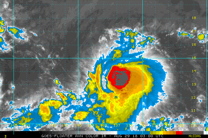
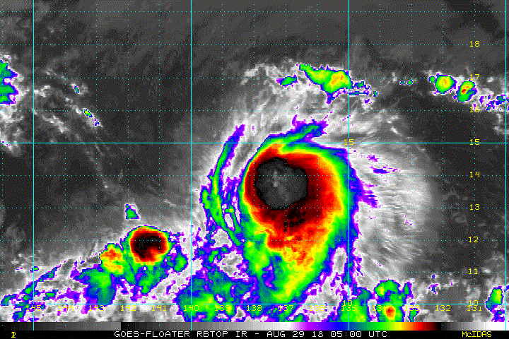
Miriam hasn't changed much over the past several hours. Last-light
visible imagery and a couple of microwave overpasses around 0000 UTC
show that the tropical storm remains lightly sheared from the
northwest. Although outflow from the deepest inner-core convection
seems to have become better established, cloud tops from outer bands
to the north and east are still moving toward the center of the
cyclone, indicating there is still shear below the outflow layer.
The initial intensity has been held at 55 kt, in agreement with
nearly all of the objective and subjective satellite estimates.
Miriam continues to move westward, and the forward speed is now 10
kt. The guidance remains in very good agreement on the track of
Miriam for the next 36 hours, with only slight speed differences
between the various models. Beyond that time, the tropical storm
should begin to turn north-northwestward toward a break in the
subtropical ridge created by a mid- to upper-level trough over the
central Pacific. The model spread increases drastically at this
point, with the ECMWF showing a quicker turn and a faster
north-northwestward motion than the GFS, with most of the other
guidance in between. For now, the NHC forecast has not been
significantly changed, and remains near the corrected consensus,
HCCA.
The moderate shear currently affecting Miriam is forecast by the
global models to continue for the next 24 h or so, preventing the
cyclone from strengthening significantly. Between 24 and 72 h, this
shear is forecast to decrease, allowing the cyclone to strengthen at
a quicker rate. By the end of the forecast period, Miriam should
quickly weaken as it encounters higher shear and cooler SSTs. The
HWRF is a notable outlier, showing much faster intensification, but
it is possible this model is not properly representing the shear
currently affecting Miriam. That said, if the shear decreases
sooner than expected, it is possible that Miriam could intensify
much faster than currently anticipated. The new NHC intensity
forecast is close to the intensity consensus, and shows a slightly
slower initial intensification rate for Miriam, and a faster decay
by day 5, than the previous advisory.
FORECAST POSITIONS AND MAX WINDS
INIT 28/0300Z 14.0N 132.5W 55 KT 65 MPH
12H 28/1200Z 14.0N 134.1W 60 KT 70 MPH
24H 29/0000Z 14.0N 136.2W 65 KT 75 MPH
36H 29/1200Z 14.2N 138.1W 75 KT 85 MPH
48H 30/0000Z 15.0N 139.5W 85 KT 100 MPH
72H 31/0000Z 17.5N 141.1W 85 KT 100 MPH
96H 01/0000Z 21.5N 142.0W 65 KT 75 MPH
120H 02/0000Z 26.0N 144.0W 40 KT 45 MPH
$$
Forecaster Zelinsky
NWS National Hurricane Center Miami FL EP152018
800 PM PDT Mon Aug 27 2018
Miriam hasn't changed much over the past several hours. Last-light
visible imagery and a couple of microwave overpasses around 0000 UTC
show that the tropical storm remains lightly sheared from the
northwest. Although outflow from the deepest inner-core convection
seems to have become better established, cloud tops from outer bands
to the north and east are still moving toward the center of the
cyclone, indicating there is still shear below the outflow layer.
The initial intensity has been held at 55 kt, in agreement with
nearly all of the objective and subjective satellite estimates.
Miriam continues to move westward, and the forward speed is now 10
kt. The guidance remains in very good agreement on the track of
Miriam for the next 36 hours, with only slight speed differences
between the various models. Beyond that time, the tropical storm
should begin to turn north-northwestward toward a break in the
subtropical ridge created by a mid- to upper-level trough over the
central Pacific. The model spread increases drastically at this
point, with the ECMWF showing a quicker turn and a faster
north-northwestward motion than the GFS, with most of the other
guidance in between. For now, the NHC forecast has not been
significantly changed, and remains near the corrected consensus,
HCCA.
The moderate shear currently affecting Miriam is forecast by the
global models to continue for the next 24 h or so, preventing the
cyclone from strengthening significantly. Between 24 and 72 h, this
shear is forecast to decrease, allowing the cyclone to strengthen at
a quicker rate. By the end of the forecast period, Miriam should
quickly weaken as it encounters higher shear and cooler SSTs. The
HWRF is a notable outlier, showing much faster intensification, but
it is possible this model is not properly representing the shear
currently affecting Miriam. That said, if the shear decreases
sooner than expected, it is possible that Miriam could intensify
much faster than currently anticipated. The new NHC intensity
forecast is close to the intensity consensus, and shows a slightly
slower initial intensification rate for Miriam, and a faster decay
by day 5, than the previous advisory.
FORECAST POSITIONS AND MAX WINDS
INIT 28/0300Z 14.0N 132.5W 55 KT 65 MPH
12H 28/1200Z 14.0N 134.1W 60 KT 70 MPH
24H 29/0000Z 14.0N 136.2W 65 KT 75 MPH
36H 29/1200Z 14.2N 138.1W 75 KT 85 MPH
48H 30/0000Z 15.0N 139.5W 85 KT 100 MPH
72H 31/0000Z 17.5N 141.1W 85 KT 100 MPH
96H 01/0000Z 21.5N 142.0W 65 KT 75 MPH
120H 02/0000Z 26.0N 144.0W 40 KT 45 MPH
$$
Forecaster Zelinsky