CPAC: NORMAN - Post-Tropical
Moderator: S2k Moderators
-
bob rulz
- Category 5

- Posts: 1667
- Age: 34
- Joined: Sat Jan 28, 2006 7:30 pm
- Location: Salt Lake City, Utah
Re: CPAC: NORMAN - Hurricane
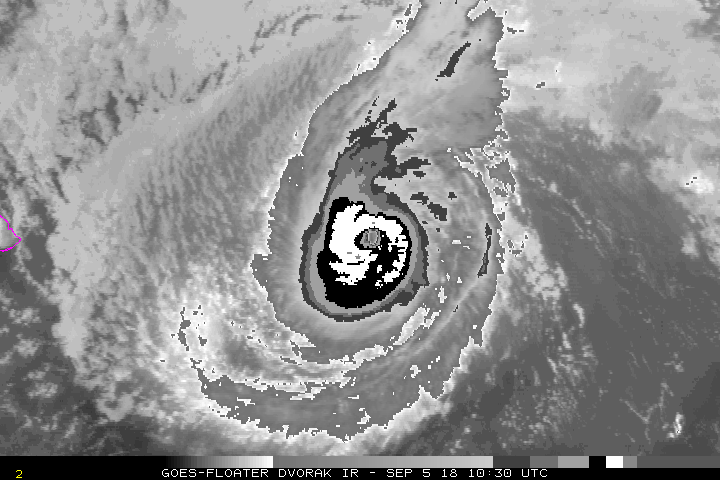
Very conservative intensity estimate based on Dvorak and satellite appearance.
2 likes
-
xtyphooncyclonex

- Category 5
- Posts: 3688
- Age: 22
- Joined: Sat Dec 08, 2012 9:07 am
- Location: Cebu City
- Contact:
Re: CPAC: NORMAN - Hurricane
This is not a category 1. This is a major hurricane. And it's moving south of west, which I did not expect.

5 likes
REMINDER: My opinions that I, or any other NON Pro-Met in this forum, are unofficial. Please do not take my opinions as an official forecast and warning. I am NOT a meteorologist. Following my forecasts blindly may lead to false alarm, danger and risk if official forecasts from agencies are ignored.
-
SconnieCane
- Category 4

- Posts: 913
- Joined: Thu Aug 02, 2018 5:29 pm
- Location: Madison, WI
Re: CPAC: NORMAN - Hurricane
EPAC just continues to overachieve even while the Atlantic also heats up. Meanwhile in the WPAC, Japan just got an unusually damaging blow from TY Jebi. Must be September! 
3 likes
-
Yellow Evan

- Professional-Met

- Posts: 15951
- Age: 25
- Joined: Fri Jul 15, 2011 12:48 pm
- Location: Henderson, Nevada/Honolulu, HI
- Contact:
-
Yellow Evan
- Professional-Met
- Posts: 15951
- Age: 25
- Joined: Fri Jul 15, 2011 12:48 pm
- Location: Henderson, Nevada/Honolulu, HI
- Contact:
Re: CPAC: NORMAN - Hurricane
* EAST PACIFIC 2018 SHIPS INTENSITY FORECAST *
* IR SAT DATA AVAILABLE, OHC AVAILABLE *
* NORMAN EP162018 09/05/18 12 UTC *
TIME (HR) 0 6 12 18 24 36 48 60 72 84 96 108 120
V (KT) NO LAND 100 105 105 101 95 80 65 52 40 36 25 17 DIS
V (KT) LAND 100 105 105 101 95 80 65 52 40 36 25 17 DIS
V (KT) LGEM 100 106 105 101 95 82 69 56 43 35 28 23 19
Storm Type TROP TROP TROP TROP TROP TROP TROP TROP TROP TROP TROP TROP TROP
SHEAR (KT) 14 13 11 16 24 25 39 41 52 49 53 55 42
SHEAR ADJ (KT) 0 2 2 8 5 9 2 7 0 3 1 -4 0
SHEAR DIR 282 274 256 231 232 218 227 223 230 231 244 258 278
SST (C) 26.9 26.8 26.7 26.7 26.7 26.6 26.2 25.9 25.9 25.9 25.7 25.4 25.2
POT. INT. (KT) 132 131 130 130 130 128 125 122 121 121 118 115 114
200 MB T (C) -51.9 -52.1 -52.1 -52.2 -52.4 -52.2 -52.3 -52.3 -52.8 -53.2 -53.2 -53.5 -54.0
200 MB VXT (C) 0.6 0.5 0.5 0.6 0.9 0.8 0.8 0.4 0.1 0.1 0.4 0.0 0.1
TH_E DEV (C) 7 7 7 7 7 7 6 6 6 6 6 6 6
700-500 MB RH 43 44 43 45 45 43 43 40 38 35 34 31 32
MODEL VTX (KT) 21 21 20 21 21 20 19 17 15 16 12 12 9
850 MB ENV VOR 61 56 52 58 47 38 30 -2 -15 -21 -28 -49 -72
200 MB DIV 2 16 18 4 4 42 16 22 0 15 -9 -22 -26
700-850 TADV 0 2 3 1 4 15 13 19 14 8 10 9 8
LAND (KM) 796 707 619 556 498 456 471 505 568 648 723 797 870
LAT (DEG N) 19.5 19.7 19.9 20.3 20.7 21.7 23.0 24.4 25.7 26.8 27.8 28.8 29.8
LONG(DEG W) 147.2 148.0 148.9 149.5 150.2 151.1 152.0 153.0 154.1 154.9 155.5 156.2 157.2
STM SPEED (KT) 9 8 8 7 7 7 8 8 7 6 6 6 7
HEAT CONTENT 10 8 9 6 5 7 2 0 0 0 0 0 0
FORECAST TRACK FROM OFCI INITIAL HEADING/SPEED (DEG/KT):265/ 10 CX,CY: -9/ 0
T-12 MAX WIND: 70 PRESSURE OF STEERING LEVEL (MB): 677 (MEAN=584)
GOES IR BRIGHTNESS TEMP. STD DEV. 50-200 KM RAD: 8.6 (MEAN=14.5)
% GOES IR PIXELS WITH T < -20 C 50-200 KM RAD: 86.0 (MEAN=65.0)
PRELIM RI PROB (DV .GE. 55 KT IN 48 HR): 0.0
INDIVIDUAL CONTRIBUTIONS TO INTENSITY CHANGE
6 12 18 24 36 48 60 72 84 96 108 120
----------------------------------------------------------
SAMPLE MEAN CHANGE 0. 0. 1. 1. 1. 1. 1. 0. -1. -1. -2. -3.
SST POTENTIAL -1. -2. -3. -5. -10. -16. -23. -30. -35. -39. -41. -42.
VERTICAL SHEAR MAG -2. -3. -5. -8. -13. -19. -22. -26. -29. -34. -40. -47.
VERTICAL SHEAR ADJ 0. 0. 0. 0. -1. -1. 0. 0. 1. 1. 1. 1.
VERTICAL SHEAR DIR 0. 0. -1. -1. -1. 0. 1. 2. 4. 5. 7. 8.
PERSISTENCE 8. 11. 12. 10. 7. 4. 1. -2. -3. -4. -6. -7.
200/250 MB TEMP. 0. 0. 0. 0. 1. 2. 4. 6. 8. 8. 8. 6.
THETA_E EXCESS 0. 0. 0. 1. 1. 1. 1. 1. 1. 0. 0. 0.
700-500 MB RH 0. 0. -1. -1. -2. -3. -4. -5. -5. -5. -6. -7.
MODEL VTX TENDENCY 0. 0. 0. 0. -1. -2. -5. -9. -8. -14. -13. -17.
850 MB ENV VORTICITY 0. 0. 0. 0. 0. 0. 0. 0. 0. 1. 1. 2.
200 MB DIVERGENCE 0. 0. -1. -1. -1. -1. -1. -2. -2. -3. -3. -4.
850-700 T ADVEC 0. 0. 0. 0. 0. 0. 1. 2. 2. 3. 4. 5.
ZONAL STORM MOTION 0. 0. 0. 1. 1. 1. 1. 1. 1. 0. 0. 0.
STEERING LEVEL PRES 0. 0. 0. 1. 1. 1. 1. 1. 2. 2. 2. 2.
DAYS FROM CLIM. PEAK 0. 0. 0. 0. 0. 0. 1. 1. 2. 2. 2. 2.
GOES PREDICTORS 0. 0. 0. 0. 0. 1. 1. 1. 0. 1. 1. 1.
OCEAN HEAT CONTENT 0. 0. 0. 0. 0. 0. -1. 0. 0. 0. 0. 0.
RI POTENTIAL 0. 0. -1. -1. -2. -3. -3. -2. 0. 1. 2. 3.
----------------------------------------------------------
TOTAL CHANGE 5. 5. 1. -5. -20. -35. -48. -60. -64. -75. -83. -96.
CURRENT MAX WIND (KT): 100. LAT, LON: 19.5 147.2
** 2018 E. Pacific RI INDEX EP162018 NORMAN 09/05/18 12 UTC **
(SHIPS-RII PREDICTOR TABLE for 30 KT OR MORE MAXIMUM WIND INCREASE IN NEXT 24-h)
Predictor Value RI Predictor Range Scaled Value(0-1) % Contribution
POT = MPI-VMAX (KT) : 30.5 40.5 to 149.3 0.00 0.0
12 HR PERSISTENCE (KT) : 30.0 -22.0 to 44.0 0.79 999.0
850-200 MB SHEAR (KT) : 15.5 19.6 to 1.4 0.23 999.0
HEAT CONTENT (KJ/CM2) : 7.6 1.8 to 106.7 0.06 999.0
D200 (10**7s-1) : 8.8 -33.0 to 156.2 0.22 999.0
STD DEV OF IR BR TEMP : 8.6 37.8 to 2.1 0.82 999.0
MAXIMUM WIND (KT) : 100.0 22.5 to 132.0 0.43 999.0
BL DRY-AIR FLUX (W/M2) : 840.8 721.6 to -82.5 0.00 0.0
%area of TPW <45 mm upshear : 17.3 62.3 to 0.0 0.72 999.0
2nd PC OF IR BR TEMP : 0.1 2.2 to -1.9 0.51 999.0
SHIPS Prob RI for 20kt/ 12hr RI threshold= 21% is 3.4 times climatological mean ( 6.1%)
SHIPS Prob RI for 25kt/ 24hr RI threshold= 0% is 0.0 times climatological mean (12.5%)
SHIPS Prob RI for 30kt/ 24hr RI threshold= 0% is 0.0 times climatological mean ( 8.4%)
SHIPS Prob RI for 35kt/ 24hr RI threshold= 0% is 0.0 times climatological mean ( 6.0%)
SHIPS Prob RI for 40kt/ 24hr RI threshold= 0% is 0.0 times climatological mean ( 4.0%)
SHIPS Prob RI for 45kt/ 36hr RI threshold= 0% is 0.0 times climatological mean ( 6.5%)
SHIPS Prob RI for 55kt/ 48hr RI threshold= 0% is 0.0 times climatological mean ( 5.9%)
SHIPS Prob RI for 65kt/ 72hr RI threshold= 0% is 0.0 times climatological mean ( 4.8%)
Matrix of RI probabilities
------------------------------------------------------------------------------
RI (kt / h) | 20/12 | 25/24 | 30/24 | 35/24 | 40/24 | 45/36 | 55/48 |65/72
------------------------------------------------------------------------------
SHIPS-RII: 21.0% 0.0% 0.0% 0.0% 0.0% 0.0% 0.0% 0.0%
Logistic: 4.5% 0.6% 0.8% 0.6% 0.3% 0.3% 0.2% 0.0%
Bayesian: 0.1% 0.0% 0.0% 0.0% 0.0% 0.0% 0.0% 0.0%
Consensus: 8.5% 0.2% 0.3% 0.2% 0.1% 0.1% 0.1% 0.0%
DTOPS: 5.0% 1.0% 1.0% 0.0% 0.0% 0.0% 0.0% 0.0%
## ANNULAR HURRICANE INDEX (AHI) EP162018 NORMAN 09/05/18 12 UTC ##
## STORM NOT ANNULAR, SCREENING STEP FAILED, NPASS=6 NFAIL=1 ##
## AHI= 0 (AHI OF 100 IS BEST FIT TO ANN. STRUC., 1 IS MARGINAL, 0 IS NOT ANNULAR) ##
CONTRIBUTIONS TO ANNULAR INDEX
0 likes


Re: CPAC: NORMAN - Hurricane
Norman's rejuvination today likely will get him over 30 units of ACE. Also notice how close he is to Hawaii. Forecast though will be a miss.
2 likes
The above post and any post by Ntxw is NOT an official forecast and should not be used as such. It is just the opinion of the poster and may or may not be backed by sound meteorological data. It is NOT endorsed by any professional institution including Storm2k. For official information, please refer to NWS products.
Help support Storm2K!

Re: CPAC: NORMAN - Hurricane
Norman is quite resilient. Just about joined the 30 ACE unit club and might go for another 5-7 units.

5 likes
The above post and any post by Ntxw is NOT an official forecast and should not be used as such. It is just the opinion of the poster and may or may not be backed by sound meteorological data. It is NOT endorsed by any professional institution including Storm2k. For official information, please refer to NWS products.
Help support Storm2K!
Help support Storm2K!
-
xtyphooncyclonex
- Category 5
- Posts: 3688
- Age: 22
- Joined: Sat Dec 08, 2012 9:07 am
- Location: Cebu City
- Contact:
Re: CPAC: NORMAN - Hurricane
Five days ago
120H 06/0000Z 21.2N 146.3W 65 KT 75 MPH
Now, it's way further southwest and stronger than forecast...
16E NORMAN 180906 0000 19.8N 148.8W EPAC 105 960
120H 06/0000Z 21.2N 146.3W 65 KT 75 MPH
Now, it's way further southwest and stronger than forecast...
16E NORMAN 180906 0000 19.8N 148.8W EPAC 105 960
4 likes
REMINDER: My opinions that I, or any other NON Pro-Met in this forum, are unofficial. Please do not take my opinions as an official forecast and warning. I am NOT a meteorologist. Following my forecasts blindly may lead to false alarm, danger and risk if official forecasts from agencies are ignored.
-
1900hurricane

- Category 5
- Posts: 6044
- Age: 32
- Joined: Fri Feb 06, 2015 12:04 pm
- Location: Houston, TX
- Contact:
Re: CPAC: NORMAN - Hurricane
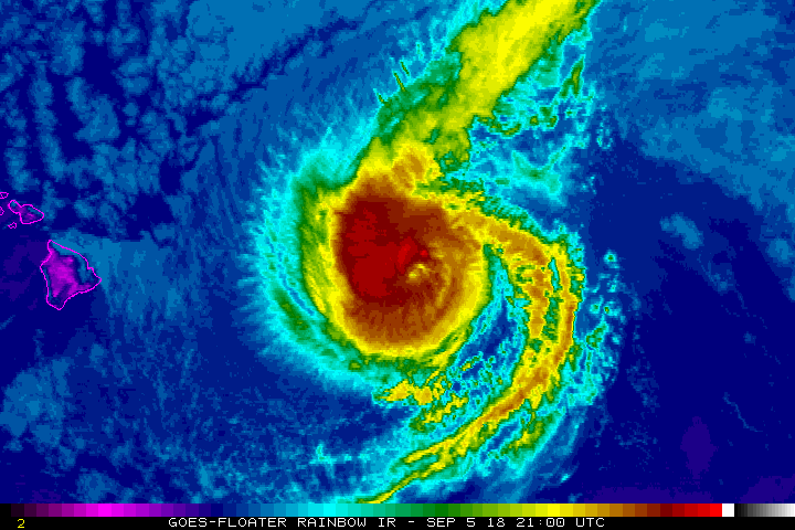
I haven't really gotten a chance to look at Norman today, so I was a little surprised to see the Island of Hawaii in the floater frame.
3 likes
Contract Meteorologist. TAMU & MSST. Fiercely authentic, one of a kind. We are all given free will, so choose a life meant to be lived. We are the Masters of our own Stories.
Opinions expressed are mine alone.
Follow me on Twitter at @1900hurricane : Read blogs at https://1900hurricane.wordpress.com/
Opinions expressed are mine alone.
Follow me on Twitter at @1900hurricane : Read blogs at https://1900hurricane.wordpress.com/
Re: CPAC: NORMAN - Hurricane
1900hurricane wrote:I haven't really gotten a chance to look at Norman today, so I was a little surprised to see the Island of Hawaii in the floater frame.
He is quite close but will miss to the north
2 likes
The above post and any post by Ntxw is NOT an official forecast and should not be used as such. It is just the opinion of the poster and may or may not be backed by sound meteorological data. It is NOT endorsed by any professional institution including Storm2k. For official information, please refer to NWS products.
Help support Storm2K!
Help support Storm2K!
-
cycloneye

- Admin

- Posts: 139019
- Age: 67
- Joined: Thu Oct 10, 2002 10:54 am
- Location: San Juan, Puerto Rico
Re: CPAC: NORMAN - Hurricane
Hurricane Norman Discussion Number 37
NWS Central Pacific Hurricane Center Honolulu HI EP162018
1100 PM HST Wed Sep 05 2018
Cold convective cloud tops persist within the inner core of Norman,
but the eye has started to become cloud-filled as the system begins
to feel the effects of increasing wind shear. Subjective Dvorak
current intensity estimates ranged from 5.0/90 kt at SAB to 5.5/102
kt out of HFO and JTWC, while CIMSS ADT came in with a higher
estimate of 107 kt. Given the steady state nature of the satellite
presentation through most of today, the intensity will be held at
105 kt for this advisory.
The long-awaited turn toward the northwest is underway, with the
initial motion set at west-northwest (295 degrees) at 7 kt. Norman
will gradually turn toward the northwest on Thursday as the
hurricane heads toward a weakness in the deep ridge centered far to
the northeast. The northwestward motion will persist through the
weekend as Norman interacts with a mid- to upper-level trough
sitting to the northwest. The track forecast is essentially an
update of the prior advisory through 48 hours and was nudged
slightly west of the prior advisory afterward. The track forecast
is nearest to TVCE, FSSE, and HCCA and is down the middle of the
guidance envelope, which is tightly clustered through 48 hours then
spreads considerably thereafter. None of the reliable guidance
suggests direct impacts from Norman on the main Hawaiian Islands.
However, as the tropical cyclone will be in our general vicinity for
the next couple of days, people should continue to monitor the
progress of this system.
Although Norman has been maintaining intensity, weakening will
commence shortly. As Norman approaches a weakness in the deep ridge,
it is encountering increasing southwesterly vertical wind shear that
is being produced by the mid- to upper-level trough parked to the
northwest. This wind shear will steadily increase through Saturday
and remain in place through the next five days. In addition, SSTs
will begin to cool late Thursday. The combined effect will be
steady weakening, which will likely render Norman a post-tropical
remnant low on late Sunday or Monday. The rate of weakening has been
accelerated slightly compared to the prior advisory, but the
intensity forecast remains on the higher side of a tightly clustered
guidance envelope of both the dynamical and statistical models.
FORECAST POSITIONS AND MAX WINDS
INIT 06/0900Z 20.3N 149.8W 105 KT 120 MPH
12H 06/1800Z 20.9N 150.8W 95 KT 110 MPH
24H 07/0600Z 21.9N 151.8W 85 KT 100 MPH
36H 07/1800Z 22.9N 152.9W 70 KT 80 MPH
48H 08/0600Z 24.0N 154.1W 55 KT 65 MPH
72H 09/0600Z 26.2N 156.6W 35 KT 40 MPH
96H 10/0600Z 28.0N 158.4W 30 KT 35 MPH...POST-TROP/REMNT LOW
120H 11/0600Z 30.0N 161.0W 25 KT 30 MPH...POST-TROP/REMNT LOW
$$
Forecaster Wroe
0 likes
Visit the Caribbean-Central America Weather Thread where you can find at first post web cams,radars
and observations from Caribbean basin members Click Here
and observations from Caribbean basin members Click Here
-
cycloneye
- Admin
- Posts: 139019
- Age: 67
- Joined: Thu Oct 10, 2002 10:54 am
- Location: San Juan, Puerto Rico
Re: CPAC: NORMAN - Hurricane
Hurricane Norman Discussion Number 38
NWS Central Pacific Hurricane Center Honolulu HI EP162018
500 AM HST Thu Sep 06 2018
Increasing southwesterly vertical wind shear of around 25 kt has
begun to take its toll Norman. Although deep convection remains
vigorous in the inner core, the eye is no longer apparent on
infrared imagery. Subjective Dvorak current intensity estimates came
in at 5.0/90 kt from all fix agencies. CIMSS ADT continues to
suggest a stronger system at 105 kt, and given the resilience of the
convection near the center, the initial intensity will be
conservatively dropped to 100 kt.
The initial motion is set at west-northwest (300 degrees) at 7 kt.
Norman will gradually turn toward the northwest today as the
hurricane heads into a weakness in the deep ridge centered far to
the northeast. The northwestward motion will persist through the
weekend as Norman interacts with a mid- to upper-level trough
sitting to the northwest. The track forecast was changed little from
the prior advisory through 72 hours and was shifted slightly to the
right the prior advisory thereafter. The track forecast is nearest
to TVCE and HCCA and is down the middle of a guidance envelope that
has a significant increase in spread with time. Although the GFS and
ECMWF are slightly left of the official track, none of the reliable
guidance would lead to a direct impact from Norman on the main
Hawaiian Islands. However, as the tropical cyclone will remain in
our general vicinity for the next couple of days, people should
continue to monitor the progress of this system.
Weakening will continue. As Norman enters a weakness in the deep
ridge, it is encountering increasing southwesterly vertical wind
shear that is being produced by the mid- to upper-level trough
parked to the northwest. This wind shear will steadily increase
through Saturday and remain in place through at least Sunday. In
addition, SSTs will begin to cool later today. The combined effect
will be steady weakening, which will likely render Norman a
post-tropical remnant low on late Sunday or Monday. The intensity
forecast is essentially an update of the prior advisory and runs
down the middle of a fairly tightly clustered guidance envelope near
ICON through the next 72 hours. Guidance spread increases at 96
hours, and with vertical wind shear expected to remain high, the
forecast favors SHIPS, which continues to weaken Norman.
FORECAST POSITIONS AND MAX WINDS
INIT 06/1500Z 20.7N 150.5W 100 KT 115 MPH
12H 07/0000Z 21.4N 151.3W 90 KT 105 MPH
24H 07/1200Z 22.4N 152.4W 75 KT 85 MPH
36H 08/0000Z 23.5N 153.5W 60 KT 70 MPH
48H 08/1200Z 24.6N 154.8W 45 KT 50 MPH
72H 09/1200Z 26.7N 156.8W 30 KT 35 MPH
96H 10/1200Z 28.7N 158.2W 25 KT 30 MPH...POST-TROP/REMNT LOW
120H 11/1200Z 30.9N 160.9W 25 KT 30 MPH...POST-TROP/REMNT LOW
$$
Forecaster Wroe
0 likes
Visit the Caribbean-Central America Weather Thread where you can find at first post web cams,radars
and observations from Caribbean basin members Click Here
and observations from Caribbean basin members Click Here
-
Mauistorms
- Tropical Low

- Posts: 49
- Joined: Thu Aug 16, 2018 6:13 pm
Re: CPAC: NORMAN - Hurricane
Big black clouds over Eastern Maui this morning... should we expect some thunderstorms from Norman or is this just regular trade showers.
0 likes
-
cycloneye
- Admin
- Posts: 139019
- Age: 67
- Joined: Thu Oct 10, 2002 10:54 am
- Location: San Juan, Puerto Rico
Re: CPAC: NORMAN - Tropical Storm
Tropical Storm Norman Discussion Number 45
NWS Central Pacific Hurricane Center Honolulu HI EP162018
1100 PM HST Fri Sep 07 2018
The exposed low-level circulation center (LLCC) of Norman remains
clearly evident in infrared and fog product satellite imagery this
evening, with diminishing deep convection confined only to the
northeast quadrant in a strongly sheared pattern. The subjective
Dvorak current intensity estimate came in at 3.5/55 kt from PHFO,
while JTWC estimated 3.0 or 45-50 kt using the subtropical method.
Objective intensity estimates are lower, with CIMSS SATCON showing
44 kt, and CIMSS ADT 2.8/41 kt. Recent satellite images since the
06Z synoptic time also show the remaining deep convection becoming
increasingly separated from the LLCC. Out of respect for the
stronger winds found around midday today by the 53rd Weather
Reconnaissance Squadron aircraft penetration as well as the 2001Z
ASCAT pass, will lower the initial intensity for this advisory only
slightly to 55 kt.
The initial motion estimate for this advisory is 335/8 kt. Norman
continues to move to the north-northwest between a deep-layer ridge
centered to the east, and a longwave trough to the northwest. The
latest track guidance has shifted a bit more to the right, in better
agreement with the motion of Norman during the past 18 hours or so,
and shows the cyclone continuing on a north-northwest to northward
course during the next 2 to 3 days. The new track forecast lies
close to the consensus HCCA and TVCE objective aids, and was shifted
only slightly to the right from the previous forecast.
The CIMSS vertical wind shear estimate for this advisory is 230/56
kt, and is supported by recent GOES satellite-derived upper-level
wind retrievals. Very strong wind shear of 45-55 kt will persist
over Norman for the next 36 hours, with some decrease possible
thereafter. However, the system is forecast to be moving over cool
SSTs below 25C by that time. The combined effects of the shear and
increasingly cool water should cause Norman to steadily weaken
to a remnant low by 72 hours, then dissipate by day 5. It is worth
noting that the GFS and ECMWF models maintain Norman as a stronger
system, possibly transitioning toward extratropical after 72 hours,
while the hurricane dynamical and statistical models show more rapid
weakening. The official intensity forecast compromises between these
extremes, and delays dissipation as compared to the statistical
guidance, but does not keep Norman as strong as the GFS/EC and does
not show extratropical transition. If the recent loss of deep
convection near the LLCC persists, Norman could become post-tropical
considerable sooner than indicated in this forecast.
FORECAST POSITIONS AND MAX WINDS
INIT 08/0900Z 25.6N 153.6W 55 KT 65 MPH
12H 08/1800Z 26.8N 154.0W 50 KT 60 MPH
24H 09/0600Z 28.6N 154.3W 45 KT 50 MPH
36H 09/1800Z 30.3N 154.3W 40 KT 45 MPH
48H 10/0600Z 32.3N 154.0W 35 KT 40 MPH
72H 11/0600Z 34.5N 154.5W 30 KT 35 MPH...POST-TROP/REMNT LOW
96H 12/0600Z 35.5N 156.0W 25 KT 30 MPH...POST-TROP/REMNT LOW
120H 13/0600Z...DISSIPATED
$$
Forecaster Jacobson
0 likes
Visit the Caribbean-Central America Weather Thread where you can find at first post web cams,radars
and observations from Caribbean basin members Click Here
and observations from Caribbean basin members Click Here
-
galaxy401

- Category 5
- Posts: 2298
- Age: 28
- Joined: Sat Aug 25, 2012 9:04 pm
- Location: Casa Grande, Arizona
Re: CPAC: NORMAN - Tropical Storm
Not like anyone really cares at this point but Norman is RIP.
BULLETIN
Tropical Storm Norman Advisory Number 47
NWS Central Pacific Hurricane Center Honolulu HI EP162018
1100 AM HST Sat Sep 08 2018
...NORMAN QUICKLY BECOMING POST-TROPICAL...
...THIS IS THE LAST ADVISORY...
Tropical Storm Norman Advisory Number 47
NWS Central Pacific Hurricane Center Honolulu HI EP162018
1100 AM HST Sat Sep 08 2018
...NORMAN QUICKLY BECOMING POST-TROPICAL...
...THIS IS THE LAST ADVISORY...
0 likes
Got my eyes on moving right into Hurricane Alley: Florida.
-
HurricaneRyan
- Category 2

- Posts: 712
- Age: 30
- Joined: Sun Dec 05, 2010 3:05 pm
Re: CPAC: NORMAN - Tropical Storm
Norman got overshadowed by Olivia and the Atlantic trio in the last few days. Bye Norman!
0 likes
Kay '22 Hilary '23
Who is online
Users browsing this forum: No registered users and 14 guests