
ATL: FLORENCE - Post-Tropical - Discussion
Moderator: S2k Moderators
-
cycloneye

- Admin

- Posts: 139009
- Age: 67
- Joined: Thu Oct 10, 2002 10:54 am
- Location: San Juan, Puerto Rico
Re: ATL: SIX - Potential Tropical Cyclone - Discussion
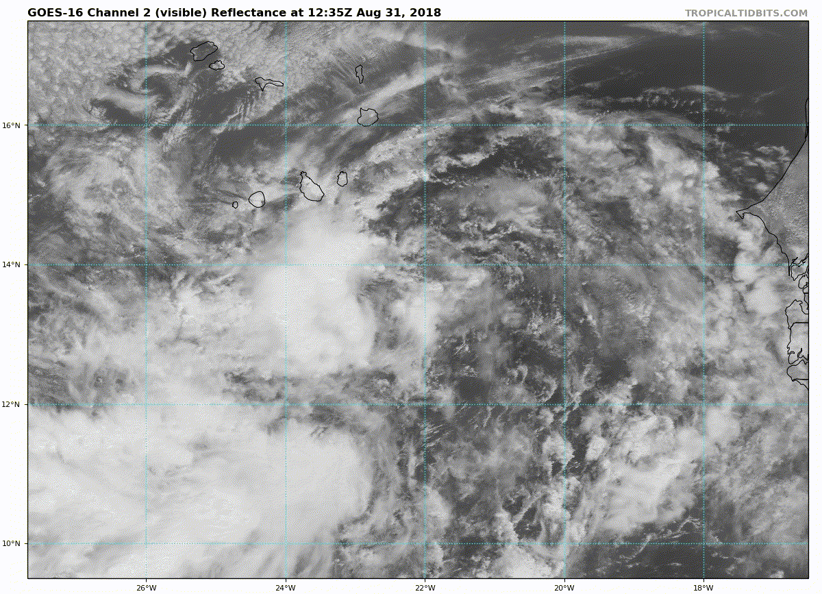
Convection is increasing but still the low pressure is exposed to the east.
1 likes
Visit the Caribbean-Central America Weather Thread where you can find at first post web cams,radars
and observations from Caribbean basin members Click Here
and observations from Caribbean basin members Click Here

Re: ATL: SIX - Potential Tropical Cyclone - Discussion
The southwest continues to blossom but minimal convection elsewhere. The center of circulation (such as it is) has almost no convection. Will be interesting to see readings from the Cape Verde islands - maybe they'll see something our satellites do not.
1 likes
Eyes: Emily '86, Dean '89, Felix '95, Gert '99, Fabian '03, Humberto '19, Paulette '20
-
cycloneye
- Admin
- Posts: 139009
- Age: 67
- Joined: Thu Oct 10, 2002 10:54 am
- Location: San Juan, Puerto Rico
Re: ATL: SIX - Potential Tropical Cyclone - Discussion
Potential Tropical Cyclone Six Discussion Number 5
NWS National Hurricane Center Miami FL AL062018
1100 AM AST Fri Aug 31 2018
The circulation is better defined this morning, but the associated
convection is rather weak. In fact, Dvorak numbers have not
changed overall, and do not support classifying the system as a
tropical cyclone yet. It seems like both NHC and the global models
predicted the development of a cyclone too soon. Nevertheless, the
environmental conditions are favorable for both genesis and
strengthening, and a tropical depression or a storm is expected to
form later today or Saturday. The shear does not appear to be a
problem at this time, but the cyclone should be moving over marginal
SSTs, limiting the amount of intensification. The HWRF model
changed its tune to a more reasonable one, and it now shows more
modest strengthening. The NHC forecast is similar to the previous
one, and continues to be very close to the intensity consensus.
The disturbance is moving toward the west-northwest or 285 degrees
at about 11 kt. The subtropical high should continue to steer the
system toward the west-northwest with some increase in forward
speed for the next 2 to 3 days. After that time, a weakness in the
ridge will induce a more northwestward track over the open Atlantic
Ocean. This is supported by the track guidance which continues to
be in very good agreement for the next 3 days. Thereafter, the
guidance envelope widens and becomes bounded by the westernmost
ECMWF and the easternmost GFS models decreasing the confidence
in the track forecast.
FORECAST POSITIONS AND MAX WINDS
INIT 31/1500Z 13.7N 22.7W 30 KT 35 MPH...POTENTIAL TROP CYCLONE
12H 01/0000Z 14.1N 24.5W 35 KT 40 MPH...TROPICAL STORM
24H 01/1200Z 14.8N 27.0W 40 KT 45 MPH
36H 02/0000Z 15.5N 29.5W 45 KT 50 MPH
48H 02/1200Z 16.2N 32.1W 50 KT 60 MPH
72H 03/1200Z 17.5N 37.5W 55 KT 65 MPH
96H 04/1200Z 19.5N 42.0W 60 KT 70 MPH
120H 05/1200Z 22.0N 45.5W 65 KT 75 MPH
$$
Forecaster Avila
0 likes
Visit the Caribbean-Central America Weather Thread where you can find at first post web cams,radars
and observations from Caribbean basin members Click Here
and observations from Caribbean basin members Click Here
-
cycloneye
- Admin
- Posts: 139009
- Age: 67
- Joined: Thu Oct 10, 2002 10:54 am
- Location: San Juan, Puerto Rico
Re: ATL: SIX - Potential Tropical Cyclone - Discussion
The truth from Avila.
It seems like both NHC and the global models
predicted the development of a cyclone too soon.
predicted the development of a cyclone too soon.
6 likes
Visit the Caribbean-Central America Weather Thread where you can find at first post web cams,radars
and observations from Caribbean basin members Click Here
and observations from Caribbean basin members Click Here
Re: ATL: SIX - Potential Tropical Cyclone - Discussion
a weakness in the ridge will induce a more northwestward track over the open Atlantic Ocean. This is supported by the track guidance which continues to
be in very good agreement for the next 3 days. Thereafter, the guidance envelope widens and becomes bounded by the westernmost ECMWF and the easternmost GFS models decreasing the confidence in the track forecast..
Avila
be in very good agreement for the next 3 days. Thereafter, the guidance envelope widens and becomes bounded by the westernmost ECMWF and the easternmost GFS models decreasing the confidence in the track forecast..
Avila
The consensus is eroding, particularly as a weaker system will be picked up less quickly and less firmly by this expected trough. Bermuda, pay attention.
0 likes
Eyes: Emily '86, Dean '89, Felix '95, Gert '99, Fabian '03, Humberto '19, Paulette '20
-
AutoPenalti
- Category 5

- Posts: 3949
- Age: 27
- Joined: Mon Aug 17, 2015 4:16 pm
- Location: Ft. Lauderdale, Florida
Re: ATL: SIX - Potential Tropical Cyclone - Discussion
plasticup wrote:a weakness in the ridge will induce a more northwestward track over the open Atlantic Ocean. This is supported by the track guidance which continues to
be in very good agreement for the next 3 days. Thereafter, the guidance envelope widens and becomes bounded by the westernmost ECMWF and the easternmost GFS models decreasing the confidence in the track forecast..
Avila
The consensus is eroding, particularly as a weaker system will be picked up less quickly and less firmly by this expected trough. Bermuda, pay attention.
More and more I’m starting to think twice about whether or not this is going to intensify enough that it will feel the weakness.
0 likes
The posts in this forum are NOT official forecasts and should not be used as such. They are just the opinion of the poster and may or may not be backed by sound meteorological data. They are NOT endorsed by any professional institution or STORM2K. For official information, please refer to products from the NHC and NWS.
Model Runs Cheat Sheet:
GFS (5:30 AM/PM, 11:30 AM/PM)
HWRF, GFDL, UKMET, NAVGEM (6:30-8:00 AM/PM, 12:30-2:00 AM/PM)
ECMWF (1:45 AM/PM)
TCVN is a weighted averaged
Re: ATL: SIX - Potential Tropical Cyclone - Discussion
Latest IR images show the convention continuing and the circulation moving under it. Much better than this morning. Roughly back to where we were yesterday.
0 likes
Eyes: Emily '86, Dean '89, Felix '95, Gert '99, Fabian '03, Humberto '19, Paulette '20
-
tolakram
- Admin
- Posts: 19165
- Age: 60
- Joined: Sun Aug 27, 2006 8:23 pm
- Location: Florence, KY (name is Mark)
Re: ATL: SIX - Potential Tropical Cyclone - Discussion
0 likes
M a r k
- - - - -
Join us in chat: Storm2K Chatroom Invite. Android and IOS apps also available.
The posts in this forum are NOT official forecasts and should not be used as such. Posts are NOT endorsed by any professional institution or STORM2K.org. For official information and forecasts, please refer to NHC and NWS products.
-
wxman57

- Moderator-Pro Met

- Posts: 22480
- Age: 66
- Joined: Sat Jun 21, 2003 8:06 pm
- Location: Houston, TX (southwest)
Re: ATL: SIX - Potential Tropical Cyclone - Discussion
Doesn't look very impressive this morning. I don't see it becoming a TS until it's well past the Cape Verde Islands. May not become a hurricane for 6-7 days. Interesting that the overnight GFS had it still as a strong hurricane 16 days from now, blocked and heading toward Newfoundland or Nova Scotia. We may be dealing with "Florence" for 2-3 weeks.
4 likes
-
Shell Mound
- Category 5
- Posts: 2434
- Age: 31
- Joined: Thu Sep 07, 2017 3:39 pm
- Location: St. Petersburg, FL → Scandinavia
Re: ATL: SIX - Potential Tropical Cyclone - Discussion
https://twitter.com/webberweather/status/1035483767069204480
https://twitter.com/RaleighWx/status/1035486226688733189
https://twitter.com/webberweather/status/1035486746308423680
https://twitter.com/webberweather/status/1035521202301874187
https://twitter.com/AndyHazelton/status/1035488482687430657
https://twitter.com/hurricanetrack/status/1035499683911794689
Note that a non-negligible number of EPS ensemble members (westernmost of three clusters) even suggest a long-range Southeast (Carolinas) threat.
0 likes
CVW / MiamiensisWx / Shell Mound
The posts in this forum are NOT official forecasts and should not be used as such. They are just the opinion of the poster and may or may not be backed by sound meteorological data. They are NOT endorsed by any professional institution or STORM2K. For official information, please refer to products from the NHC and NWS.
-
Kazmit

- Category 5
- Posts: 1915
- Age: 21
- Joined: Mon Jul 25, 2016 8:49 am
- Location: Williamsburg VA for college, Bermuda otherwise
Re: ATL: SIX - Potential Tropical Cyclone - Discussion
I don't think it will really take off much until it reaches the warm ssts in the subtropics next week. Until then, I think it'll stay relatively weak, which could help it get more west than expected.
0 likes
Igor 2010, Sandy 2012, Fay 2014, Gonzalo 2014, Joaquin 2015, Nicole 2016, Humberto 2019
I am only a tropical weather enthusiast. My predictions are not official and may or may not be backed by sound meteorological data. For official information, please refer to the NHC and NWS products.
I am only a tropical weather enthusiast. My predictions are not official and may or may not be backed by sound meteorological data. For official information, please refer to the NHC and NWS products.
-
storminabox
- Category 1

- Posts: 260
- Joined: Sun Jul 09, 2017 10:50 pm
Re: ATL: SIX - Potential Tropical Cyclone - Discussion
wxman57 wrote:Doesn't look very impressive this morning. I don't see it becoming a TS until it's well past the Cape Verde Islands. May not become a hurricane for 6-7 days. Interesting that the overnight GFS had it still as a strong hurricane 16 days from now, blocked and heading toward Newfoundland or Nova Scotia. We may be dealing with "Florence" for 2-3 weeks.
Once it gets going it will be a big ACE maker for sure.
1 likes

Re: ATL: SIX - Potential Tropical Cyclone - Discussion
At 1700 UTC the center is near 13.2N, -24.5W and there was enough convection blossoming again that the models will probably initialize well. Its kind of dry out there (notice the cloud pattern to the NW) and the last system was poofed by shear. I think it would be good news if it stalled and kept the weakness open east of Bermuda, but first it has to survive the dry environment.
0 likes
-
cycloneye
- Admin
- Posts: 139009
- Age: 67
- Joined: Thu Oct 10, 2002 10:54 am
- Location: San Juan, Puerto Rico
ATL: FLORENCE - Tropical Storm - Discussion
BULLETIN
Potential Tropical Cyclone Six Intermediate Advisory Number 5A
NWS National Hurricane Center Miami FL AL062018
200 PM AST Fri Aug 31 2018
...RAINBANDS AND GUSTY WINDS APPROACHING THE SOUTHERN CABO VERDE
ISLANDS...
SUMMARY OF 200 PM AST...1800 UTC...INFORMATION
----------------------------------------------
LOCATION...13.8N 23.3W
ABOUT 100 MI...165 KM SE OF THE SOUTHERNMOST CABO VERDE ISLANDS
MAXIMUM SUSTAINED WINDS...35 MPH...55 KM/H
PRESENT MOVEMENT...WNW OR 285 DEGREES AT 13 MPH...20 KM/H
MINIMUM CENTRAL PRESSURE...1006 MB...29.71 INCHES
0 likes
Visit the Caribbean-Central America Weather Thread where you can find at first post web cams,radars
and observations from Caribbean basin members Click Here
and observations from Caribbean basin members Click Here
-
NotSparta

- Professional-Met

- Posts: 1645
- Age: 22
- Joined: Fri Aug 18, 2017 8:24 am
- Location: Naples, FL
- Contact:
Re: ATL: SIX - Tropical Depression - Discussion
Now is a TD
AL, 06, 2018083118, , BEST, 0, 138N, 240W, 30, 1004, TD
3 likes
This post was probably an opinion of mine, and in no way is official. Please refer to http://www.hurricanes.gov for official tropical analysis and advisories.
My website, with lots of tropical wx graphics, including satellite and recon: http://cyclonicwx.com
My website, with lots of tropical wx graphics, including satellite and recon: http://cyclonicwx.com
Re: ATL: SIX - Tropical Depression - Discussion
NotSparta wrote:Now is a TDAL, 06, 2018083118, , BEST, 0, 138N, 240W, 30, 1004, TD
Convection on the IR from the low level center is being lightly sheared SSW.
1 likes
-
NotSparta
- Professional-Met
- Posts: 1645
- Age: 22
- Joined: Fri Aug 18, 2017 8:24 am
- Location: Naples, FL
- Contact:
Re: ATL: SIX - Tropical Depression - Discussion
Nimbus wrote:NotSparta wrote:Now is a TDAL, 06, 2018083118, , BEST, 0, 138N, 240W, 30, 1004, TD
Convection on the IR from the low level center is being lightly sheared SSW.
Yeah, wind from the AEJ/TEJ is causing some easterly shear right now. As it moves west, this shear gets lower
0 likes
This post was probably an opinion of mine, and in no way is official. Please refer to http://www.hurricanes.gov for official tropical analysis and advisories.
My website, with lots of tropical wx graphics, including satellite and recon: http://cyclonicwx.com
My website, with lots of tropical wx graphics, including satellite and recon: http://cyclonicwx.com

-
cycloneye
- Admin
- Posts: 139009
- Age: 67
- Joined: Thu Oct 10, 2002 10:54 am
- Location: San Juan, Puerto Rico
Re: ATL: SIX - Tropical Depression - Discussion
Tropical Depression Six Discussion Number 6
NWS National Hurricane Center Miami FL AL062018
500 PM AST Fri Aug 31 2018
High resolution satellite images reveal that the disturbance has
developed a well-defined circulation with a cyclonically curved
convective band near the center, and plenty of showers in the
southern semicircle. The surface pressure in the Cabo Verde Island
of Santiago dropped to 1005 mb at 1800 UTC as the cyclone passed to
its south. In addition, Dvorak numbers are gradually increasing, and
now support classifying the system as a tropical depression.
The depression is becoming better organized, and it will most likely
reach tropical storm status in the next several hours. The
environmental conditions are favorable for some strengthening during
the next 2 to 3 days while the shear is low. Later in the forecast
period, the shear is expected to increase, and the SSTs will become
marginal halting the strengthing process. The models, primarily the
HWRF, are a little less aggressive with the intensity, so the NHC
forecast is adjusted slightly downward.
Now that the center has formed, we have a better estimate of the
initial motion, which is toward the west or 270 degrees at 13 kt.
The depression is gradually becoming steered by the flow around the
subtropical ridge, and consequently it has increased its forward
speed. This prevailing flow pattern should keep the cyclone on a
general west to west-northwest track for the next 2 to 3 days. After
that time, a weakness in the ridge will induce a more northwestward
to north-northwestward track over the open Atlantic Ocean. The
track guidance is very consistent with this solution mainly for the
next 3 days. Thereafter, the confidence in the track forecast
decreases as the guidance envelope widens and becomes bounded by the
westernmost ECMWF and the easternmost HWFI. The NHC forecast
continues to be in the middle of the envelope and is very close
to the corrected consensus HCCA, which has had great skill so far
this year.
FORECAST POSITIONS AND MAX WINDS
INIT 31/2100Z 13.8N 24.7W 30 KT 35 MPH
12H 01/0600Z 14.3N 26.7W 35 KT 40 MPH
24H 01/1800Z 14.9N 29.2W 40 KT 45 MPH
36H 02/0600Z 15.8N 31.8W 45 KT 50 MPH
48H 02/1800Z 16.5N 34.5W 50 KT 60 MPH
72H 03/1800Z 18.0N 39.5W 55 KT 65 MPH
96H 04/1800Z 20.0N 44.0W 60 KT 70 MPH
120H 05/1800Z 23.0N 48.0W 55 KT 65 MPH
$$
Forecaster Avila

0 likes
Visit the Caribbean-Central America Weather Thread where you can find at first post web cams,radars
and observations from Caribbean basin members Click Here
and observations from Caribbean basin members Click Here
Who is online
Users browsing this forum: No registered users and 15 guests