ATL: ISAAC - Models

Moderator: S2k Moderators

Message
Author
User avatar
gatorcane
S2K Supporter
S2K Supporter
Posts: 23499
Age: 46
Joined: Sun Mar 13, 2005 3:54 pm
Location: Boca Raton, FL

Re: ATL: INVEST 92L - Models

#61 Postby gatorcane » Wed Sep 05, 2018 11:55 am

Kazmit wrote:It's finally recurving now, but could be a Bermuda threat.


It is recurving at 300+ hours, where model accuracy is not good.
1 likes   

User avatar
chris_fit
Category 5
Category 5
Posts: 3078
Joined: Wed Sep 10, 2003 11:58 pm
Location: Tampa Bay Area, FL
Contact:

Re: ATL: INVEST 92L - Models

#62 Postby chris_fit » Wed Sep 05, 2018 12:10 pm

gatorcane wrote:
Kazmit wrote:It's finally recurving now, but could be a Bermuda threat.


It is recurving at 300+ hours, where model accuracy is not good.


This. I believe many models showed Irma recurving way before FL this far out
0 likes   

User avatar
cycloneye
Admin
Admin
Posts: 139049
Age: 67
Joined: Thu Oct 10, 2002 10:54 am
Location: San Juan, Puerto Rico

Re: ATL: INVEST 92L - Models

#63 Postby cycloneye » Wed Sep 05, 2018 1:37 pm

12z Euro goes west with a Hurricane.Let's see how the run ends.

Image
1 likes   
Visit the Caribbean-Central America Weather Thread where you can find at first post web cams,radars
and observations from Caribbean basin members Click Here

User avatar
SoupBone
Category 5
Category 5
Posts: 3073
Joined: Tue Sep 20, 2005 5:24 pm

Re: ATL: INVEST 92L - Models

#64 Postby SoupBone » Wed Sep 05, 2018 1:50 pm

At 216, it hits the brakes and heads north. :lol:
0 likes   
Personal Forecast Disclaimer:
The posts in this forum are NOT official forecast and should not be used as such. They are just the opinion of the poster and may or may not be backed by sound meteorological data. They are NOT endorsed by any professional institution or storm2k.org. For official information, please refer to the NHC and NWS products.

User avatar
AubreyStorm
Category 1
Category 1
Posts: 322
Age: 43
Joined: Fri Jun 16, 2017 6:21 pm
Location: Texas, USA

Re: ATL: INVEST 92L - Models

#65 Postby AubreyStorm » Wed Sep 05, 2018 1:52 pm

Up

Image
1 likes   
The posts are NOT an official forecast. Please REFER to the NHC and NWS for official forecasts and products.

jlauderdal
S2K Supporter
S2K Supporter
Posts: 6771
Joined: Wed May 19, 2004 5:46 am
Location: NE Fort Lauderdale
Contact:

Re: ATL: INVEST 92L - Models

#66 Postby jlauderdal » Wed Sep 05, 2018 1:53 pm

SoupBone wrote:At 216, it hits the brakes and heads north. :lol:
the florence effect in action
0 likes   

supercane4867
Category 5
Category 5
Posts: 4966
Joined: Wed Nov 14, 2012 10:43 am

Re: ATL: INVEST 92L - Models

#67 Postby supercane4867 » Wed Sep 05, 2018 1:53 pm

12 EC has a low cutting off to its north and pulling it OTS. Still way too soon to determine if it's a random feature or not.
0 likes   

User avatar
cycloneye
Admin
Admin
Posts: 139049
Age: 67
Joined: Thu Oct 10, 2002 10:54 am
Location: San Juan, Puerto Rico

Re: ATL: INVEST 92L - Models

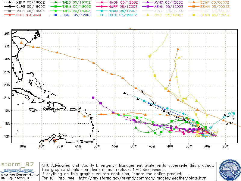
#68 Postby cycloneye » Wed Sep 05, 2018 1:58 pm

SHIP is bullish.

* ATLANTIC 2018 SHIPS INTENSITY FORECAST *
* IR SAT DATA AVAILABLE, OHC AVAILABLE *
* INVEST AL922018 09/05/18 18 UTC *

TIME (HR) 0 6 12 18 24 36 48 60 72 84 96 108 120
V (KT) NO LAND 25 27 28 30 32 37 45 53 60 65 70 76 84
V (KT) LAND 25 27 28 30 32 37 45 53 60 65 70 76 84
V (KT) LGEM 25 25 26 26 27 30 35 42 48 51 52 56 64
Storm Type TROP TROP TROP TROP TROP TROP TROP TROP TROP TROP TROP TROP TROP

SHEAR (KT) 18 16 15 11 11 7 6 10 12 11 6 5 15
SHEAR ADJ (KT) 3 2 3 3 0 0 -1 -2 -4 -1 5 4 4
SHEAR DIR 84 84 75 74 65 91 168 214 240 273 314 25 44
SST (C) 28.4 28.2 28.0 27.8 27.5 27.2 26.9 26.7 26.5 26.6 26.8 27.3 27.8
POT. INT. (KT) 142 139 136 133 129 125 121 120 118 120 122 128 133
ADJ. POT. INT. 139 134 130 126 121 117 112 111 111 114 116 123 127
200 MB T (C) -53.3 -53.6 -53.8 -53.7 -53.5 -53.9 -53.6 -54.1 -53.6 -54.0 -53.7 -53.9 -53.5
200 MB VXT (C) 0.0 -0.1 0.0 0.0 0.0 0.0 0.0 0.0 0.0 0.0 0.0 0.1 0.1
TH_E DEV (C) 6 6 5 5 5 5 5 4 5 6 7 7 8
700-500 MB RH 70 67 66 65 66 67 64 65 60 55 51 52 54
MODEL VTX (KT) 13 13 12 11 11 11 12 14 16 16 17 17 19
850 MB ENV VOR 132 123 111 105 101 95 106 113 109 101 105 104 105
200 MB DIV 23 19 16 11 19 27 33 62 60 51 28 46 45
700-850 TADV 0 0 1 1 0 0 -1 0 0 0 1 -1 -4
LAND (KM) 1181 1244 1297 1342 1390 1504 1632 1751 1934 2028 1803 1579 1392
LAT (DEG N) 12.2 12.6 13.1 13.6 14.1 14.7 15.4 15.9 16.3 16.2 15.5 14.2 13.0
LONG(DEG W) 28.1 28.8 29.4 29.9 30.4 31.5 32.7 33.8 35.5 37.4 39.6 41.2 42.4
STM SPEED (KT) 9 8 7 7 7 6 6 7 9 11 10 10 7
HEAT CONTENT 8 11 12 11 9 3 0 0 0 0 8 6 8

FORECAST TRACK FROM TABM INITIAL HEADING/SPEED (DEG/KT):295/ 10 CX,CY: -8/ 4
T-12 MAX WIND: 25 PRESSURE OF STEERING LEVEL (MB): 519 (MEAN=619)
GOES IR BRIGHTNESS TEMP. STD DEV. 50-200 KM RAD: 17.0 (MEAN=14.5)
% GOES IR PIXELS WITH T < -20 C 50-200 KM RAD: 70.0 (MEAN=65.0)
PRELIM RI PROB (DV .GE. 55 KT IN 48 HR): 0.6

INDIVIDUAL CONTRIBUTIONS TO INTENSITY CHANGE
6 12 18 24 36 48 60 72 84 96 108 120
----------------------------------------------------------
SAMPLE MEAN CHANGE 1. 2. 3. 4. 6. 8. 9. 10. 11. 12. 12. 13.
SST POTENTIAL 0. 0. 0. 1. 3. 8. 13. 17. 21. 24. 26. 29.
VERTICAL SHEAR MAG 1. 1. 2. 3. 5. 6. 7. 7. 6. 7. 8. 7.
VERTICAL SHEAR ADJ 0. 0. 0. -1. 0. 0. 1. 2. 2. 1. 1. 0.
VERTICAL SHEAR DIR 0. 1. 2. 2. 4. 5. 5. 3. 2. 2. 3. 4.
PERSISTENCE 0. -1. -1. -1. 0. 0. 0. 0. 0. 0. 0. 0.
200/250 MB TEMP. 0. -1. -1. -1. -1. -1. 0. 0. 0. 0. 0. 1.
THETA_E EXCESS 0. 0. -1. -1. -1. -2. -2. -2. -2. -2. -1. -1.
700-500 MB RH 0. 0. -1. -1. -1. -2. -3. -4. -4. -4. -3. -3.
MODEL VTX TENDENCY 0. -1. -1. -2. -3. -3. -1. 0. 0. 0. 0. 1.
850 MB ENV VORTICITY 0. 1. 1. 1. 2. 3. 4. 4. 5. 6. 7. 7.
200 MB DIVERGENCE 0. 0. 0. 0. -1. -1. 0. 0. 0. 0. 0. 0.
850-700 T ADVEC 0. 0. 0. 0. 0. 0. 0. 0. 0. 0. 0. 0.
ZONAL STORM MOTION 0. 0. 0. 0. 0. 0. 0. 0. 0. 1. 1. 1.
STEERING LEVEL PRES 0. 0. 0. 0. 1. 1. 0. 1. 1. 1. 1. 1.
DAYS FROM CLIM. PEAK 0. 0. 0. 0. 0. 0. 0. 0. -1. -1. -1. -1.
GOES PREDICTORS 0. 1. 1. 1. 1. 0. 0. -1. -1. -2. -2. -2.
OCEAN HEAT CONTENT 0. 0. 0. 0. 0. 0. 0. 0. 0. 0. 0. 0.
RI POTENTIAL 0. 0. 0. -1. -2. -2. -2. -2. -1. -1. 0. 0.
----------------------------------------------------------
TOTAL CHANGE 2. 3. 5. 7. 12. 20. 28. 35. 40. 45. 51. 59.

CURRENT MAX WIND (KT): 25. LAT, LON: 12.2 28.1

** 2018 ATLANTIC RI INDEX AL922018 INVEST 09/05/18 18 UTC **
(SHIPS-RII PREDICTOR TABLE for 30 KT OR MORE MAXIMUM WIND INCREASE IN NEXT 24-h)

Predictor Value RI Predictor Range Scaled Value(0-1) % Contribution
12 HR PERSISTENCE (KT) : 0.0 -49.5 to 38.5 0.56 4.8
850-200 MB SHEAR (KT) : 14.1 30.1 to 2.3 0.58 2.2
HEAT CONTENT (KJ/CM2) : 10.2 0.0 to 157.3 0.06 0.3
STD DEV OF IR BR TEMP : 17.0 36.6 to 2.8 0.58 1.9
2nd PC OF IR BR TEMP : -0.9 2.9 to -2.9 0.66 2.1
MAXIMUM WIND (KT) : 25.0 22.5 to 132.0 0.07 0.1
BL DRY-AIR FLUX (W/M2) : 103.8 893.2 to -67.1 0.82 1.9
POT = MPI-VMAX (KT) : 105.1 28.4 to 141.4 0.68 0.4
D200 (10**7s-1) : 17.6 -29.7 to 185.9 0.22 0.1
%area of TPW <45 mm upshear : 0.0 100.0 to 0.0 1.00 0.2

SHIPS Prob RI for 20kt/ 12hr RI threshold= 5% is 1.0 times climatological mean ( 5.0%)
SHIPS Prob RI for 25kt/ 24hr RI threshold= 17% is 1.6 times climatological mean (10.9%)
SHIPS Prob RI for 30kt/ 24hr RI threshold= 14% is 2.1 times climatological mean ( 6.7%)
SHIPS Prob RI for 35kt/ 24hr RI threshold= 9% is 2.4 times climatological mean ( 3.8%)
SHIPS Prob RI for 40kt/ 24hr RI threshold= 0% is 0.0 times climatological mean ( 2.4%)
SHIPS Prob RI for 45kt/ 36hr RI threshold= 0% is 0.0 times climatological mean ( 4.5%)
SHIPS Prob RI for 55kt/ 48hr RI threshold= 10% is 2.2 times climatological mean ( 4.6%)
SHIPS Prob RI for 65kt/ 72hr RI threshold= 0% is 0.0 times climatological mean ( 5.4%)

Matrix of RI probabilities
------------------------------------------------------------------------------
RI (kt / h) | 20/12 | 25/24 | 30/24 | 35/24 | 40/24 | 45/36 | 55/48 |65/72
------------------------------------------------------------------------------
SHIPS-RII: 4.8% 17.1% 13.9% 9.0% 0.0% 0.0% 10.3% 0.0%
Logistic: 3.5% 13.9% 6.6% 3.0% 2.8% 11.5% 16.3% 13.1%
Bayesian: 0.4% 6.7% 1.0% 0.0% 0.0% 0.6% 0.9% 3.5%
Consensus: 2.9% 12.6% 7.2% 4.0% 0.9% 4.0% 9.2% 5.5%
DTOPS: 0.0% 0.0% 0.0% 0.0% 0.0% 0.0% 0.0% 0.0%

** PROBLTY OF AT LEAST 1 SCNDRY EYEWL FORMTN EVENT AL922018 INVEST 09/05/2018 18 UTC **
TIME(HR) 0-12 12-24(0-24) 24-36(0-36) 36-48(0-48)
CLIMO(%) 0 0( 0) 0( 0) 0( 0) <-- PROB BASED ON INTENSITY ONLY
PROB(%) 0 0( 0) 0( 0) 0( 0) <-- FULL MODEL PROB (RAN NORMALLY)

** DSHIPS INTENSITY FORECAST ADJUSTED RELATIVE TO ONSET OF ERC WEAKENING PHASE **
TIME (HR) 0 6 12 18 24 36 48 60 72 84 96 108 120
>24HR AGO (DSHIPS) 25 27 28 30 32 37 45 53 60 65 70 76 84
18HR AGO 25 24 25 27 29 34 42 50 57 62 67 73 81
12HR AGO 25 22 21 23 25 30 38 46 53 58 63 69 77
6HR AGO 25 19 16 15 17 22 30 38 45 50 55 61 69
NOW CURRENT INTENSITY < 83 KT
IN 6HR INTENSITY IN 6HR < 83 KT
IN 12HR INTENSITY IN 12HR < 83 KT
1 likes   
Visit the Caribbean-Central America Weather Thread where you can find at first post web cams,radars
and observations from Caribbean basin members Click Here

User avatar
SoupBone
Category 5
Category 5
Posts: 3073
Joined: Tue Sep 20, 2005 5:24 pm

Re: ATL: INVEST 92L - Models

#69 Postby SoupBone » Wed Sep 05, 2018 2:24 pm

Image
0 likes   
Personal Forecast Disclaimer:
The posts in this forum are NOT official forecast and should not be used as such. They are just the opinion of the poster and may or may not be backed by sound meteorological data. They are NOT endorsed by any professional institution or storm2k.org. For official information, please refer to the NHC and NWS products.

User avatar
cycloneye
Admin
Admin
Posts: 139049
Age: 67
Joined: Thu Oct 10, 2002 10:54 am
Location: San Juan, Puerto Rico

Re: ATL: INVEST 92L - Models

#70 Postby cycloneye » Wed Sep 05, 2018 2:49 pm

Anyone has the 12z ensembles from GFS,UKMET and ECMWF for 92L?
0 likes   
Visit the Caribbean-Central America Weather Thread where you can find at first post web cams,radars
and observations from Caribbean basin members Click Here

JPmia
S2K Supporter
S2K Supporter
Posts: 1070
Joined: Thu Jun 03, 2004 11:01 pm
Location: Fort Lauderdale, FL

Re: ATL: INVEST 92L - Models

#71 Postby JPmia » Wed Sep 05, 2018 3:14 pm

cycloneye wrote:Anyone has the 12z ensembles from GFS,UKMET and ECMWF for 92L?


https://ruc.noaa.gov/hfip/tceps/tceps.php?model=ukmo
2 likes   

User avatar
cycloneye
Admin
Admin
Posts: 139049
Age: 67
Joined: Thu Oct 10, 2002 10:54 am
Location: San Juan, Puerto Rico

Re: ATL: INVEST 92L - Models

#72 Postby cycloneye » Wed Sep 05, 2018 3:20 pm

JPmia wrote:
cycloneye wrote:Anyone has the 12z ensembles from GFS,UKMET and ECMWF for 92L?


https://ruc.noaa.gov/hfip/tceps/tceps.php?model=ukmo


Thanks for the link.
1 likes   
Visit the Caribbean-Central America Weather Thread where you can find at first post web cams,radars
and observations from Caribbean basin members Click Here

WeatherEmperor
S2K Supporter
S2K Supporter
Posts: 4806
Age: 40
Joined: Thu Sep 04, 2003 2:54 pm
Location: South Florida

Re: ATL: INVEST 92L - Models

#73 Postby WeatherEmperor » Wed Sep 05, 2018 5:46 pm

Ouch! Lets hope this does not happen

Image


Sent from my iPhone using Tapatalk
0 likes   

User avatar
toad strangler
S2K Supporter
S2K Supporter
Posts: 4162
Joined: Sun Jul 28, 2013 3:09 pm
Location: Earth
Contact:

Re: ATL: INVEST 92L - Models

#74 Postby toad strangler » Wed Sep 05, 2018 6:27 pm

92L sneaks into very interesting position around the area of Puerto Rico. Then things get wonky with Florence sucking up everything in the basin with her as she exits the NE. Not so sure about all that.
1 likes   

User avatar
SFLcane
S2K Supporter
S2K Supporter
Posts: 9606
Age: 46
Joined: Sat Jun 05, 2010 1:44 pm
Location: Lake Worth Florida

Re: ATL: INVEST 92L - Models

#75 Postby SFLcane » Wed Sep 05, 2018 8:55 pm

toad strangler wrote:92L sneaks into very interesting position around the area of Puerto Rico. Then things get wonky with Florence sucking up everything in the basin with her as she exits the NE. Not so sure about all that.


I agree toad Iam not buying 92L being yanked NE on a dime. Lots of time to watch
3 likes   

User avatar
abajan
S2K Supporter
S2K Supporter
Posts: 4175
Joined: Sun Sep 07, 2003 5:10 am
Location: Barbados

Re: ATL: INVEST 92L - Models

#76 Postby abajan » Wed Sep 05, 2018 11:23 pm

Initially, it looked like the 00z GFS was going to be less ominous than the 18z, and that 92L would miss the islands, but I'm not so sure now. We'll see shortly.
0 likes   

User avatar
SoupBone
Category 5
Category 5
Posts: 3073
Joined: Tue Sep 20, 2005 5:24 pm

Re: ATL: INVEST 92L - Models

#77 Postby SoupBone » Wed Sep 05, 2018 11:27 pm

abajan wrote:Initially, it looked like the 00z GFS was going to be less ominous than the 18z, and that 92L would miss the islands, but I'm not so sure now. We'll see shortly.


At 174 it scrapes the Virgin Islands with 1007 pressure.
Last edited by SoupBone on Wed Sep 05, 2018 11:30 pm, edited 2 times in total.
1 likes   
Personal Forecast Disclaimer:
The posts in this forum are NOT official forecast and should not be used as such. They are just the opinion of the poster and may or may not be backed by sound meteorological data. They are NOT endorsed by any professional institution or storm2k.org. For official information, please refer to the NHC and NWS products.

User avatar
abajan
S2K Supporter
S2K Supporter
Posts: 4175
Joined: Sun Sep 07, 2003 5:10 am
Location: Barbados

Re: ATL: INVEST 92L - Models

#78 Postby abajan » Wed Sep 05, 2018 11:28 pm

Just a tad north of the last run, I think.
0 likes   

User avatar
SoupBone
Category 5
Category 5
Posts: 3073
Joined: Tue Sep 20, 2005 5:24 pm

Re: ATL: INVEST 92L - Models

#79 Postby SoupBone » Wed Sep 05, 2018 11:30 pm

abajan wrote:Just a tad north of the last run, I think.


I finally see why it misses Florence's weakness. For about 30 hours (between hour 42-72), the GFS has it meandering around before moving west. Strange. Stranger even, the wave right behind it finds a way to gain latitude.
0 likes   
Personal Forecast Disclaimer:
The posts in this forum are NOT official forecast and should not be used as such. They are just the opinion of the poster and may or may not be backed by sound meteorological data. They are NOT endorsed by any professional institution or storm2k.org. For official information, please refer to the NHC and NWS products.

User avatar
SoupBone
Category 5
Category 5
Posts: 3073
Joined: Tue Sep 20, 2005 5:24 pm

Re: ATL: INVEST 92L - Models

#80 Postby SoupBone » Thu Sep 06, 2018 12:07 am

Looking at it in motion, I think that's 92L that then regenerates and heads toward Florida.


Image
0 likes   
Personal Forecast Disclaimer:
The posts in this forum are NOT official forecast and should not be used as such. They are just the opinion of the poster and may or may not be backed by sound meteorological data. They are NOT endorsed by any professional institution or storm2k.org. For official information, please refer to the NHC and NWS products.


Return to “2018”

Who is online

Users browsing this forum: No registered users and 39 guests