https://twitter.com/AndyHazelton/status/1043531629866684416
ATL: KIRK - Models
Moderator: S2k Moderators
-
toad strangler

- S2K Supporter

- Posts: 4162
- Joined: Sun Jul 28, 2013 3:09 pm
- Location: Earth
- Contact:
Re: ATL: KIRK - Models
0 likes

Re: ATL: KIRK - Models
Looks like an El Niño pattern in the Carribean. No way this survives that kind of shear.

0 likes
The following post is NOT an official forecast and should not be used as such. It is just the opinion of the poster and may or may not be backed by sound meteorological data. It is NOT endorsed by any professional institution including storm2k.org For Official Information please refer to the NHC and NWS products.
-
toad strangler
- S2K Supporter
- Posts: 4162
- Joined: Sun Jul 28, 2013 3:09 pm
- Location: Earth
- Contact:
Re: ATL: KIRK - Models
blp wrote:Looks like an El Niño pattern in the Carribean. No way this survives that kind of shear.
https://image.ibb.co/k0YoCU/gfs_shear_watl_25.png
That's a guillotine if it verifies. But thats the general consensus ATM along with SAL from the N. Not a good combination to say the least.
1 likes
-
Aric Dunn
- Category 5

- Posts: 21228
- Age: 41
- Joined: Sun Sep 19, 2004 9:58 pm
- Location: Ready for the Chase.
- Contact:
Re: ATL: KIRK - Models
interesting to note. both the HWRF and HMON show a series of large out flow boundaries starting in 24hrs from now. Likely a large amount of dry air entrainment. But as we have seen many times that does not always mean weaker.
0 likes
Note: If I make a post that is brief. Please refer back to previous posts for the analysis or reasoning. I do not re-write/qoute what my initial post said each time.
If there is nothing before... then just ask
Space & Atmospheric Physicist, Embry-Riddle Aeronautical University,
I believe the sky is falling...
If there is nothing before... then just ask
Space & Atmospheric Physicist, Embry-Riddle Aeronautical University,
I believe the sky is falling...
-
toad strangler
- S2K Supporter
- Posts: 4162
- Joined: Sun Jul 28, 2013 3:09 pm
- Location: Earth
- Contact:

-
Hurricaneman

- Category 5
- Posts: 7280
- Age: 43
- Joined: Tue Aug 31, 2004 3:24 pm
- Location: central florida
Re: ATL: KIRK - Models
toad strangler wrote:12z Euro .... Kirk Out
http://i218.photobucket.com/albums/cc107/softparade1313/ecmwf_uv850_vort_atl_8.png
At the 10 day though I can’t tell if it regenerates in the western Caribbean or if that’s a new system
0 likes

Re: ATL: KIRK - Models
It looks like the Euro takes whatever is left of Kirk in the Bahamas at 240 hours as a shredded up tropical wave.
0 likes
-
Aric Dunn
- Category 5
- Posts: 21228
- Age: 41
- Joined: Sun Sep 19, 2004 9:58 pm
- Location: Ready for the Chase.
- Contact:
Re: ATL: KIRK - Models
Interestingly the LGEM and SHips which the NHC weighted heavily during florence take this to a hurricane. GFS is the outlier ( again lol )

0 likes
Note: If I make a post that is brief. Please refer back to previous posts for the analysis or reasoning. I do not re-write/qoute what my initial post said each time.
If there is nothing before... then just ask
Space & Atmospheric Physicist, Embry-Riddle Aeronautical University,
I believe the sky is falling...
If there is nothing before... then just ask
Space & Atmospheric Physicist, Embry-Riddle Aeronautical University,
I believe the sky is falling...
-
AutoPenalti
- Category 5
- Posts: 3949
- Age: 27
- Joined: Mon Aug 17, 2015 4:16 pm
- Location: Ft. Lauderdale, Florida
Re: ATL: KIRK - Models
I know shear forecasts are hard to predict 3-4 days out but Kirk is going to have a hell of a journey...

1 likes
The posts in this forum are NOT official forecasts and should not be used as such. They are just the opinion of the poster and may or may not be backed by sound meteorological data. They are NOT endorsed by any professional institution or STORM2K. For official information, please refer to products from the NHC and NWS.
Model Runs Cheat Sheet:
GFS (5:30 AM/PM, 11:30 AM/PM)
HWRF, GFDL, UKMET, NAVGEM (6:30-8:00 AM/PM, 12:30-2:00 AM/PM)
ECMWF (1:45 AM/PM)
TCVN is a weighted averaged

Re: ATL: KIRK - Models
blp wrote:Looks like an El Niño pattern in the Carribean. No way this survives that kind of shear.
https://image.ibb.co/k0YoCU/gfs_shear_watl_25.png
Does "look" like a El Nino pattern of shear in the Caribbean but looking a bit further west and north, doesn't our present pattern appear more driven by a meridianal flow then the largely zonal (or split jet zonal) flow more common in an El Nino year? Only asking because within a well entrenched El Nino pattern, what you see is what you get for the most part. On the other hand, I would tend to look at present 200 mb - 500 mb wind shear as less a precursor of the future and more a reflection of present conditions and the strong mid to upper high over Texas. Furthermore, if one looks at the GFS 240 hr. Wind Shear Anomalies, it's plainly obvious that a significant drop off in shear occurs around 60W. With time, this area expands and moves west into the Central and Western Caribbean; Very possibly as a result of a significant anticyclone that could well be associated with a fairly well defined tropical system. I believe that greater research could be done toward better understanding those circumstances where some hurricanes themselves have as great (or even greater) influence on those dynamic conditions currently in place (but that discussion could be left for another newly created thread).

1 likes
Personal Forecast Disclaimer:
The posts in this forum are NOT official forecast and should not be used as such. They are just the opinion of the poster and may or may not be backed by sound meteorological data. They are NOT endorsed by any professional institution or storm2k.org. For official information, please refer to the NHC and NWS products.
The posts in this forum are NOT official forecast and should not be used as such. They are just the opinion of the poster and may or may not be backed by sound meteorological data. They are NOT endorsed by any professional institution or storm2k.org. For official information, please refer to the NHC and NWS products.

-
Aric Dunn
- Category 5
- Posts: 21228
- Age: 41
- Joined: Sun Sep 19, 2004 9:58 pm
- Location: Ready for the Chase.
- Contact:
Re: ATL: KIRK - Models
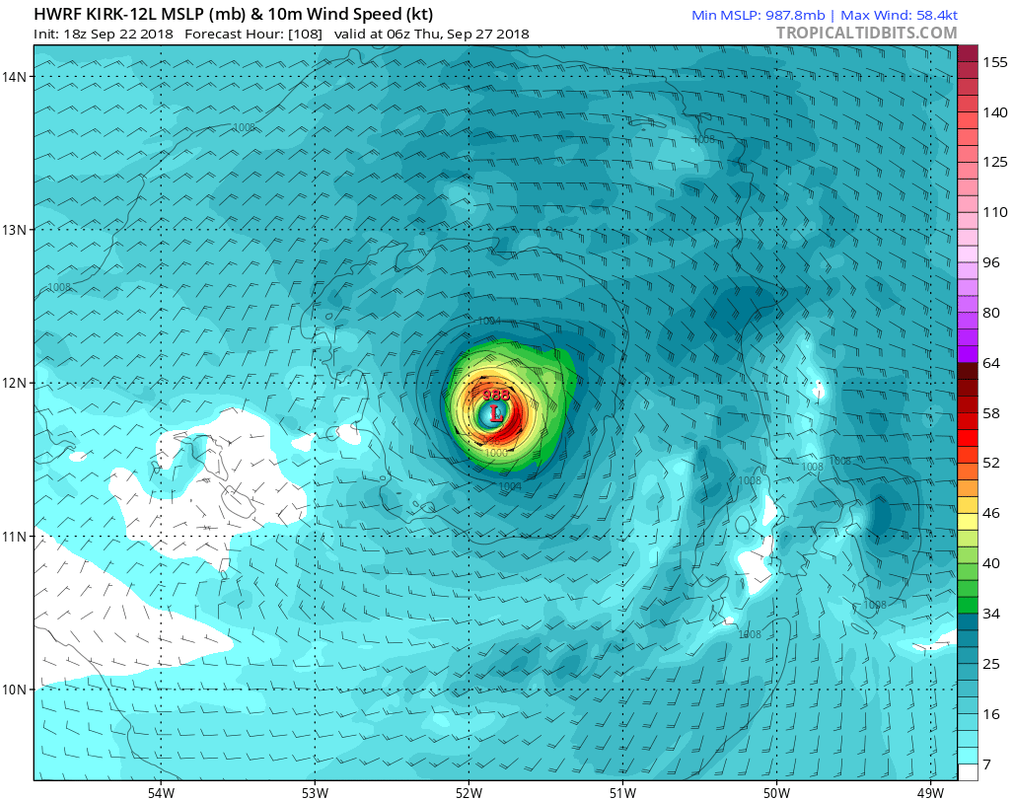
HWRF has a hurricane at 114 hrs

0 likes
Note: If I make a post that is brief. Please refer back to previous posts for the analysis or reasoning. I do not re-write/qoute what my initial post said each time.
If there is nothing before... then just ask
Space & Atmospheric Physicist, Embry-Riddle Aeronautical University,
I believe the sky is falling...
If there is nothing before... then just ask
Space & Atmospheric Physicist, Embry-Riddle Aeronautical University,
I believe the sky is falling...
Re: ATL: KIRK - Models
Aric Dunn wrote:HWRF has a hurricane at 114 hrs
https://www.tropicaltidbits.com/analysis/models/hwrf/2018092218/hwrf_mslp_wind_12L_39.png
Aric and gator,
I’m not saying Kirk couldn’t become a H E of the Lesser Antilles, but doesn’t the HWRF have an overstrengthening bias?
1 likes
Personal Forecast Disclaimer:
The posts in this forum are NOT official forecasts and should not be used as such. They are just the opinion of the poster and may or may not be backed by sound meteorological data. They are NOT endorsed by any professional institution or storm2k.org. For official information, please refer to the NHC and NWS products.
The posts in this forum are NOT official forecasts and should not be used as such. They are just the opinion of the poster and may or may not be backed by sound meteorological data. They are NOT endorsed by any professional institution or storm2k.org. For official information, please refer to the NHC and NWS products.
-
Hurricaneman
- Category 5
- Posts: 7280
- Age: 43
- Joined: Tue Aug 31, 2004 3:24 pm
- Location: central florida
Re: ATL: KIRK - Models
Aric Dunn wrote:HWRF has a hurricane at 114 hrs
https://www.tropicaltidbits.com/analysis/models/hwrf/2018092218/hwrf_mslp_wind_12L_39.png
And after that weakens Kirk substantially
0 likes
-
SEASON_CANCELED

- Category 3

- Posts: 887
- Joined: Mon Jul 06, 2009 5:17 am
- Location: 8 Bit Charlie Sheen
Re: ATL: KIRK - Models
Always thought hwrf was an intensity model
0 likes
i am a big stupid ugly moron with an ugly face and a big butt and my butt stinks and i like to kiss my own butt
Re: ATL: KIRK - Models
The 0Z Sun GEFS is far more active with Kirk in the SW Atlantic with both stronger members as well as a good bit larger number of relatively strong members going W of 60W than was any prior GEFS run fwiw. Whereas prior runs had at most very few sub 1003 mb members among the 21, this run has about half that get near or lower than 990 mb (potential H strength). About half the members recurve E of 60W but about half of the ones that don’t get recurve then subsequently get caught underneath a big NE US surface high and get close to or hit the SE US in early Oct including 2 Hs and a weaker member either hitting or getting close to FL. One goes into the GOM as a H.
1 likes
Personal Forecast Disclaimer:
The posts in this forum are NOT official forecasts and should not be used as such. They are just the opinion of the poster and may or may not be backed by sound meteorological data. They are NOT endorsed by any professional institution or storm2k.org. For official information, please refer to the NHC and NWS products.
The posts in this forum are NOT official forecasts and should not be used as such. They are just the opinion of the poster and may or may not be backed by sound meteorological data. They are NOT endorsed by any professional institution or storm2k.org. For official information, please refer to the NHC and NWS products.
-
Emmett_Brown

- Category 5
- Posts: 1343
- Joined: Wed Aug 24, 2005 9:10 pm
- Location: Sarasota FL
Re: ATL: KIRK - Models
Conditions for Kirk are marginal at best in the near term... however, there is a subtle trend on the GFS Op run to strengthen him. For example, on the 12Z GFS, Kirk has a 998 mb pressure by 30 hours. The previous run he was 1002 mb for the same point in time. Kirk still dissipates on the 12Z in the E Caribbean, however. But, the trend is interesting.
0 likes
Re: ATL: KIRK - Models
Unlike the 0Z GEFS, the 12Z GEFS is very quiet.
OTOH, the 12Z Euro is stronger and several hundred miles NE of its 0Z Euro location in the N Caribbean despite shear still being strong nearby. I think it is because it came into the Caribbean stronger.
OTOH, the 12Z Euro is stronger and several hundred miles NE of its 0Z Euro location in the N Caribbean despite shear still being strong nearby. I think it is because it came into the Caribbean stronger.
0 likes
Personal Forecast Disclaimer:
The posts in this forum are NOT official forecasts and should not be used as such. They are just the opinion of the poster and may or may not be backed by sound meteorological data. They are NOT endorsed by any professional institution or storm2k.org. For official information, please refer to the NHC and NWS products.
The posts in this forum are NOT official forecasts and should not be used as such. They are just the opinion of the poster and may or may not be backed by sound meteorological data. They are NOT endorsed by any professional institution or storm2k.org. For official information, please refer to the NHC and NWS products.
-
Hurricaneman
- Category 5
- Posts: 7280
- Age: 43
- Joined: Tue Aug 31, 2004 3:24 pm
- Location: central florida
Re: ATL: KIRK - Models
The 12zEuro shows what seems to be Kirk in the Western Caribbean at the end of its run, could the GOM have to watch Kirk beyond day 10
0 likes

Re: ATL: KIRK - Models
12Z Euro takes a stronger system into the Windward Islands than the 00Z.
0 likes
Who is online
Users browsing this forum: No registered users and 61 guests