EPAC: ROSA - Post-Tropical

Moderator: S2k Moderators

Message
Author
CaliforniaResident
Tropical Storm
Tropical Storm
Posts: 212
Joined: Fri Feb 21, 2014 1:47 pm

Re: EPAC: ROSA - Hurricane

#81 Postby CaliforniaResident » Thu Sep 27, 2018 9:17 pm

CrazyC83 wrote:If this were to threaten the California coast as a TC, I am sure they would do 6-hourly Recon missions.


We literally haven't had rainfall accumulation since early May, so bring it on!
1 likes   

User avatar
EquusStorm
Category 5
Category 5
Posts: 1649
Age: 33
Joined: Thu Nov 07, 2013 1:04 pm
Location: Jasper, AL
Contact:

Re: EPAC: ROSA - Hurricane

#82 Postby EquusStorm » Thu Sep 27, 2018 10:14 pm

125kt at 11pm advisory, forecast peak 130kt. Can certainly believe it. Ties 2015 for the most category fours in a single season according to NHC.

CI# sitting at 6.7, 132kt; definitely has a window for category five. Cloud tops haven't cooled if any much the last several frames but the CDO is much more symmetrical and the eye is nearly perfect now.
Last edited by EquusStorm on Thu Sep 27, 2018 10:17 pm, edited 1 time in total.
3 likes   
Colors of lost purpose on the canvas of irrelevance

Not a meteorologist, in fact more of an idiot than anything. You should probably check with the NHC or a local NWS office for official information.

User avatar
cycloneye
Admin
Admin
Posts: 139010
Age: 67
Joined: Thu Oct 10, 2002 10:54 am
Location: San Juan, Puerto Rico

Re: EPAC: ROSA - Hurricane

#83 Postby cycloneye » Thu Sep 27, 2018 10:14 pm

Hurricane Rosa Discussion Number 12
NWS National Hurricane Center Miami FL EP202018
800 PM PDT Thu Sep 27 2018

Rosa has continued to rapidly intensify during the past several
hours, with a distinct and warm eye noted on satellite images along
with deep eyewall convection. A blend of the latest Dvorak
estimates gives an initial wind speed estimate of 125 kt, making
Rosa the seventh category 4 hurricane of the very busy 2018 eastern
Pacific hurricane season. It is worth noting that this value ties
2015 for the highest observed seasonal total in the basin during
the satellite era.

The hurricane still has a chance to intensify further given that it
is still over warm waters within light shear. By the weekend,
however, Rosa will encounter more marginal SSTs, and the shear
will likely increase. These conditions should cause a significant
weakening of the hurricane by early next week, and for Rosa to fall
back to a tropical storm by Tuesday. The intensity forecast isn't
particularly confident at long range because of the possibility of a
trough interaction somewhat offsetting the effects of cool eastern
Pacific waters and dry stable air. So far the guidance is fairly
consistent, and the forecast continues to show steady weakening as
Rosa approaches Baja California.

Rosa continues moving at 265 deg, now at 8 kt. A mid-level ridge
over the southwestern United States is forecast to weaken and move
eastward over the next couple of days as a mean mid-tropospheric
trough forms near the west coast of the US. This synoptic pattern
should cause the tropical cyclone to gradually turn northward over
that time, and eventually move to the northeast due to Rosa getting
caught up into southwestern flow ahead of the trough. While there
are still some notable speed differences in the model guidance, the
overall trend is for a faster solution, which is consistent with a
more vertically deep system feeling the stronger mid-level flow.
The model consensus continues the faster trend, and the new
forecast follows suit.


FORECAST POSITIONS AND MAX WINDS

INIT 28/0300Z 16.9N 116.7W 125 KT 145 MPH
12H 28/1200Z 17.1N 117.7W 130 KT 150 MPH
24H 29/0000Z 17.8N 118.4W 125 KT 145 MPH
36H 29/1200Z 19.0N 118.8W 115 KT 130 MPH
48H 30/0000Z 20.9N 118.8W 100 KT 115 MPH
72H 01/0000Z 25.0N 118.0W 75 KT 85 MPH
96H 02/0000Z 29.0N 115.5W 45 KT 50 MPH
120H 03/0000Z 36.0N 110.5W 25 KT 30 MPH...POST-TROP/INLAND

$$
Forecaster Blake
0 likes   
Visit the Caribbean-Central America Weather Thread where you can find at first post web cams,radars
and observations from Caribbean basin members Click Here

CrazyC83
Professional-Met
Professional-Met
Posts: 33393
Joined: Tue Mar 07, 2006 11:57 pm
Location: Deep South, for the first time!

Re: EPAC: ROSA - Hurricane

#84 Postby CrazyC83 » Thu Sep 27, 2018 10:34 pm

EquusStorm wrote:125kt at 11pm advisory, forecast peak 130kt. Can certainly believe it. Ties 2015 for the most category fours in a single season according to NHC.

CI# sitting at 6.7, 132kt; definitely has a window for category five. Cloud tops haven't cooled if any much the last several frames but the CDO is much more symmetrical and the eye is nearly perfect now.


Based on the improvement since the advisory, I'd go with 135 kt right now personally.
4 likes   

Ntxw
Storm2k Moderator
Storm2k Moderator
Posts: 21492
Joined: Wed Oct 21, 2009 6:34 pm
Location: DFW, Texas

Re: EPAC: ROSA - Hurricane

#85 Postby Ntxw » Thu Sep 27, 2018 10:38 pm

130-135kt is definitely justifiable. Her presentation is fantastic with beautiful eye.

Image
4 likes   
The above post and any post by Ntxw is NOT an official forecast and should not be used as such. It is just the opinion of the poster and may or may not be backed by sound meteorological data. It is NOT endorsed by any professional institution including Storm2k. For official information, please refer to NWS products.

  Help support Storm2K!
Help Support Storm2K

User avatar
EquusStorm
Category 5
Category 5
Posts: 1649
Age: 33
Joined: Thu Nov 07, 2013 1:04 pm
Location: Jasper, AL
Contact:

Re: EPAC: ROSA - Hurricane

#86 Postby EquusStorm » Thu Sep 27, 2018 10:43 pm

130-135kt certainly seems reasonable right now, it certainly has that appearance. I expect the NHC to be conservative usually, but if it keeps getting even better organized and cloud tops cool just a bit more, 130-135+ is pretty unavoidable by next advisory
0 likes   
Colors of lost purpose on the canvas of irrelevance

Not a meteorologist, in fact more of an idiot than anything. You should probably check with the NHC or a local NWS office for official information.

supercane4867
Category 5
Category 5
Posts: 4966
Joined: Wed Nov 14, 2012 10:43 am

Re: EPAC: ROSA - Hurricane

#87 Postby supercane4867 » Thu Sep 27, 2018 10:55 pm

It seems increasingly likely that Rosa could be a high impact event for Arizona. Nearly all models keeps it at mid-TS strength while crossing US-Mexico boarder.
0 likes   

User avatar
Kingarabian
S2K Supporter
S2K Supporter
Posts: 15432
Joined: Sat Aug 08, 2009 3:06 am
Location: Honolulu, Hawaii

Re: EPAC: ROSA - Hurricane

#88 Postby Kingarabian » Fri Sep 28, 2018 1:39 am

Image
5 likes   
RIP Kobe Bryant

HurricaneRyan
Category 2
Category 2
Posts: 712
Age: 30
Joined: Sun Dec 05, 2010 3:05 pm

Re: EPAC: ROSA - Hurricane

#89 Postby HurricaneRyan » Fri Sep 28, 2018 2:53 am

One of the most impressive storms of the season
1 likes   
Kay '22 Hilary '23

User avatar
cycloneye
Admin
Admin
Posts: 139010
Age: 67
Joined: Thu Oct 10, 2002 10:54 am
Location: San Juan, Puerto Rico

Re: EPAC: ROSA - Hurricane

#90 Postby cycloneye » Fri Sep 28, 2018 4:42 am

Hurricane Rosa Discussion Number 13
NWS National Hurricane Center Miami FL EP202018
200 AM PDT Fri Sep 28 2018

Although enhanced BD-curve infrared imagery shows that Rosa's 20 n
mi wide eye has continued to warm (+16C) this morning, the southwest
quadrant of the eyewall appears to have weakened, or collapsed, and
the inner ring cloud tops have warmed considerably. This change in
the cloud pattern maybe the early stage of an eyewall replacement
cycle (ERC). It's certainly worth noting, however, that the
satellite presentation about 3 hours ago indicated that Rosa may
have reached a peak intensity of 130-135 kt which was also
indicated in the ADT adjusted raw T-numbers. For this advisory,
the initial intensity is set at 125 kt and is based on a compromise
of the subjective and objective satellite intensity estimates.

Rosa has a small window of opportunity to complete its ERC and
restrengthen before it encounters decreasing oceanic temperatures,
and increasing southwesterly shear. These inhibiting factors, along
with Rosa moving into a more stable air mass, should cause a
downward intensity trend by early next week, and for the cyclone to
weaken to a tropical storm by Tuesday, and a tropical depression as
it quickly moves northeastward over the southwestern U.S. The
intensity forecast is similar to my predecessor's and is close to
the IVCN consensus through 48 hours, then quite similar to the
NOAA-HCCA intensity model beyond that forecast period.

The initial motion is estimated to be westward, or 270/6 kt. A
mid-level ridge over the southwestern United States is forecast to
weaken over the next couple of days in response to an approaching
mid-level shortwave trough from the northwest. This growing
weakness in the ridge should influence Rosa to gradually turn
northward through mid-period, and afterward, turn northeastward
within the strong mid- to upper tropospheric southwesterly flow
produced by the aforementioned trough. The NHC track forecast was
adjusted ever so slightly to the left of the previous one to light
more closely to the TVCN and HCCA multi-model guidance.

FORECAST POSITIONS AND MAX WINDS

INIT 28/0900Z 16.9N 117.3W 125 KT 145 MPH
12H 28/1800Z 17.4N 117.9W 130 KT 150 MPH
24H 29/0600Z 18.4N 118.4W 120 KT 140 MPH
36H 29/1800Z 20.1N 118.8W 100 KT 115 MPH
48H 30/0600Z 22.0N 118.8W 85 KT 100 MPH
72H 01/0600Z 25.9N 117.6W 65 KT 75 MPH
96H 02/0600Z 30.6N 115.0W 40 KT 45 MPH...INLAND
120H 03/0600Z 38.2N 109.4W 25 KT 30 MPH...POST-TROP/INLAND

$$
Forecaster Roberts
0 likes   
Visit the Caribbean-Central America Weather Thread where you can find at first post web cams,radars
and observations from Caribbean basin members Click Here

SootyTern
S2K Supporter
S2K Supporter
Posts: 310
Age: 55
Joined: Sun Sep 05, 2004 5:09 pm
Location: NYC (formerly Homestead, FL)

Re: EPAC: ROSA - Hurricane

#91 Postby SootyTern » Fri Sep 28, 2018 7:08 am

HurricaneRyan wrote:One of the most impressive storms of the season


that whole basin has been full of beautiful storms not hurting anyone all season
2 likes   
Disclaimer:
The posts in this forum are NOT official forecasts and should not be used as such. For official information, please refer to the NHC and NWS products.

Gulf Coast: Opal '95 Georges '98 / So Fla: Katrina '05 Wilma '05 Irma '17

User avatar
cycloneye
Admin
Admin
Posts: 139010
Age: 67
Joined: Thu Oct 10, 2002 10:54 am
Location: San Juan, Puerto Rico

Re: EPAC: ROSA - Hurricane

#92 Postby cycloneye » Fri Sep 28, 2018 9:52 am

Hurricane Rosa Discussion Number 14
NWS National Hurricane Center Miami FL EP202018
800 AM PDT Fri Sep 28 2018

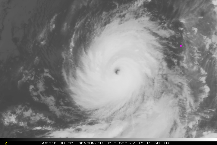
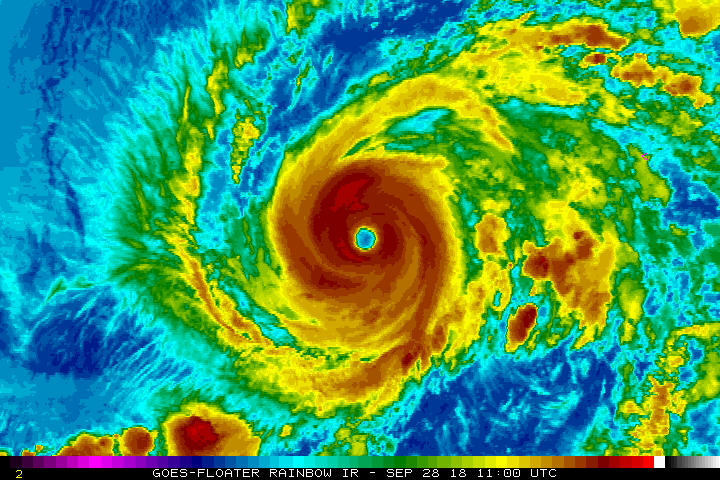
Cloud tops surrounding the distinct eye of Rosa have warmed
considerably over the past few hours. A recent SSMI overpass
showed a distinct double eyewall structure, and this is likely the
reason for the degradation of Rosa's appearance. Dvorak intensity
estimates from TAFB and SAB have decreased as a result, and the
initial intensity has been therefore decreased to 120 kt. Given
the continued warming of cloud tops since 1200 UTC, it is possible
that Rosa has weakened a little more than this.

Since an eyewall replacement cycle is ongoing, Rosa is no longer
expected to intensify. In the short term, some additional
weakening is likely, typical of major hurricanes undergoing eyewall
replacements. If this process completes within the next 24 hours,
there will be some opportunity for the hurricane to re-intensify
while the shear is low and the hurricane remains over warm SSTs.
However, steady weakening is anticipated beginning Saturday night
since the cyclone is forecast to cross over much cooler SSTs. By 96
h, a weaker Rosa will likely approach the northern west coast of
the Baja California peninsula and the resulting interaction with
land will likely cause the cyclone to dissipate. It is worth
noting that a farther northwest track would likely result in Rosa
weakening faster than currently indicated, while a farther
southwest track could allow Rosa to maintain a slightly stronger
circulation as it crosses the northern Gulf of California.

Rosa has begun its long-anticipated turn toward the northwest, and
the initial motion estimate is 315/6 kt. The track models remain
in good agreement that Rosa will gradually turn toward the north,
and then north-northeast over the next few days ahead of an
approaching mid- to upper-level trough to the northwest. No
significant changes were made to the official track forecast, but
it has been adjusted slightly to the left (or northwest) at most
times, in line with the latest consensus guidance.

Even though the NHC forecast calls for the surface circulation of
Rosa to dissipate after making landfall along the northern Baja
California coast, its associated moisture is expected to spread
northeastward through parts of the southwest United States. For
more information about potential rainfall in that area, please see
products from the Weather Prediction Center and your local NWS
forecast office.

FORECAST POSITIONS AND MAX WINDS

INIT 28/1500Z 17.2N 117.5W 120 KT 140 MPH
12H 29/0000Z 17.8N 118.1W 110 KT 125 MPH
24H 29/1200Z 19.2N 118.6W 105 KT 120 MPH
36H 30/0000Z 21.0N 118.9W 95 KT 110 MPH
48H 30/1200Z 23.0N 118.8W 80 KT 90 MPH
72H 01/1200Z 26.7N 117.4W 55 KT 65 MPH
96H 02/1200Z 31.6N 115.0W 35 KT 40 MPH...INLAND
120H 03/1200Z...DISSIPATED

$$
Forecaster Zelinsky
0 likes   
Visit the Caribbean-Central America Weather Thread where you can find at first post web cams,radars
and observations from Caribbean basin members Click Here

User avatar
NDG
S2K Supporter
S2K Supporter
Posts: 14933
Joined: Sun Jul 09, 2006 10:14 pm
Location: Orlando, FL

Re: EPAC: ROSA - Hurricane

#93 Postby NDG » Fri Sep 28, 2018 12:19 pm

What in the world just happened to Rosa? It most have sucked in some of that surface stable marine layer just to its NW.

Edit: I just read the NHC's discussion above, they think is an EWR but I've never seen one that the toll of a hurricane this bad.

Image
0 likes   

User avatar
EquusStorm
Category 5
Category 5
Posts: 1649
Age: 33
Joined: Thu Nov 07, 2013 1:04 pm
Location: Jasper, AL
Contact:

Re: EPAC: ROSA - Hurricane

#94 Postby EquusStorm » Fri Sep 28, 2018 12:30 pm

Definitely a major/classic ERC going on too but yeah, it's taking a far bigger hit than one would expect. Am kind of doubting it gets much of a second peak if it's already being affected by negative conditions, would have to recover really quickly.
4 likes   
Colors of lost purpose on the canvas of irrelevance

Not a meteorologist, in fact more of an idiot than anything. You should probably check with the NHC or a local NWS office for official information.

User avatar
1900hurricane
Category 5
Category 5
Posts: 6044
Age: 32
Joined: Fri Feb 06, 2015 12:04 pm
Location: Houston, TX
Contact:

Re: EPAC: ROSA - Hurricane

#95 Postby 1900hurricane » Fri Sep 28, 2018 12:36 pm

There’s a good chance upwelling is playing a part too.
2 likes   
Contract Meteorologist. TAMU & MSST. Fiercely authentic, one of a kind. We are all given free will, so choose a life meant to be lived. We are the Masters of our own Stories.
Opinions expressed are mine alone.

Follow me on Twitter at @1900hurricane : Read blogs at https://1900hurricane.wordpress.com/

User avatar
EquusStorm
Category 5
Category 5
Posts: 1649
Age: 33
Joined: Thu Nov 07, 2013 1:04 pm
Location: Jasper, AL
Contact:

Re: EPAC: ROSA - Hurricane

#96 Postby EquusStorm » Fri Sep 28, 2018 12:54 pm

Yeah she's really not moving very quickly at all. Can only assume the warm water depth here isn't all that great.
1 likes   
Colors of lost purpose on the canvas of irrelevance

Not a meteorologist, in fact more of an idiot than anything. You should probably check with the NHC or a local NWS office for official information.

User avatar
Yellow Evan
Professional-Met
Professional-Met
Posts: 15951
Age: 25
Joined: Fri Jul 15, 2011 12:48 pm
Location: Henderson, Nevada/Honolulu, HI
Contact:

Re: EPAC: ROSA - Hurricane

#97 Postby Yellow Evan » Fri Sep 28, 2018 1:32 pm

Models shifting back west. 12z GFS/ECMWF both have a landfall south of the US at day 4. This will probably be gone within 24 hours prior to making landfall.
0 likes   

User avatar
NDG
S2K Supporter
S2K Supporter
Posts: 14933
Joined: Sun Jul 09, 2006 10:14 pm
Location: Orlando, FL

Re: EPAC: ROSA - Hurricane

#98 Postby NDG » Fri Sep 28, 2018 1:49 pm

EquusStorm wrote:Yeah she's really not moving very quickly at all. Can only assume the warm water depth here isn't all that great.


That makes sense, the depth of the warm waters are not that great where it is now so I am sure some cold upwelling is occurring while it sits near the same area.

Image
1 likes   

supercane4867
Category 5
Category 5
Posts: 4966
Joined: Wed Nov 14, 2012 10:43 am

Re: EPAC: ROSA - Hurricane

#99 Postby supercane4867 » Fri Sep 28, 2018 2:05 pm

EWRC is near completion. Here comes the large eye contest between Rosa and Trami

Image

Image
0 likes   

Ntxw
Storm2k Moderator
Storm2k Moderator
Posts: 21492
Joined: Wed Oct 21, 2009 6:34 pm
Location: DFW, Texas

Re: EPAC: ROSA - Hurricane

#100 Postby Ntxw » Fri Sep 28, 2018 2:06 pm

Yeah upwelling, ERC, dry air all of such likely had some effect today. She peaked yesterday afternoon.

Image
1 likes   
The above post and any post by Ntxw is NOT an official forecast and should not be used as such. It is just the opinion of the poster and may or may not be backed by sound meteorological data. It is NOT endorsed by any professional institution including Storm2k. For official information, please refer to NWS products.


  Help support Storm2K!

Help Support Storm2K


Return to “2018”

Who is online

Users browsing this forum: No registered users and 23 guests