EPAC: BARBARA - Remnants

Moderator: S2k Moderators

Message
Author
User avatar
Kingarabian
S2K Supporter
S2K Supporter
Posts: 15434
Joined: Sat Aug 08, 2009 3:06 am
Location: Honolulu, Hawaii

Re: EPAC: BARBARA - Tropical Storm

#101 Postby Kingarabian » Sun Jun 30, 2019 2:48 pm

Yellow Evan wrote:The day 9 to 10 weakening is due to moving over a 10k volcano in all likelihood.

I expect shear to be a problem in general though.

Yeah. High resolution Euro shows a 976mb landfall with nearly 70kt winds making landfall between Hilo and Puna at hour 228. Between hours 228-234, it gets torn apart by one of the volcanoes.
1 likes   
RIP Kobe Bryant

User avatar
NotSparta
Professional-Met
Professional-Met
Posts: 1647
Age: 22
Joined: Fri Aug 18, 2017 8:24 am
Location: Naples, FL
Contact:

Re: EPAC: BARBARA - Tropical Storm

#102 Postby NotSparta » Sun Jun 30, 2019 3:03 pm

1900hurricane wrote:
NotSparta wrote:Barbara's convection is a bit south displaced, as you can see generally where the LLC lies, north of the center of the convective blob.

https://i.imgur.com/FfXJGRd.gif

That's pretty normal for a monsoon trough system early in its life, even in a low shear environment. As it detaches, some of the best low level convergence still remains on the south side of the system with the monsoon trough. It happens quite a bit in the Western Pacific too.


Interesting, good to know
0 likes   
This post was probably an opinion of mine, and in no way is official. Please refer to http://www.hurricanes.gov for official tropical analysis and advisories.

My website, with lots of tropical wx graphics, including satellite and recon: http://cyclonicwx.com

User avatar
cycloneye
Admin
Admin
Posts: 139059
Age: 67
Joined: Thu Oct 10, 2002 10:54 am
Location: San Juan, Puerto Rico

Re: EPAC: BARBARA - Tropical Storm

#103 Postby cycloneye » Sun Jun 30, 2019 3:36 pm

Up to 95 kts the peak but they have this sentence:

The various rapid intensification indices
suggest a 40-50 percent chance of rapid intensification from 12-72
h, and if this occurs Barbara could become a major hurricane.


BULLETIN
Tropical Storm Barbara Advisory Number 2
NWS National Hurricane Center Miami FL EP022019
300 PM MDT Sun Jun 30 2019

...BARBARA MOVING WESTWARD AND STRENGTHENING...


SUMMARY OF 300 PM MDT...2100 UTC...INFORMATION
----------------------------------------------
LOCATION...10.9N 112.2W
ABOUT 840 MI...1355 KM S OF THE SOUTHERN TIP OF BAJA CALIFORNIA
MAXIMUM SUSTAINED WINDS...45 MPH...75 KM/H
PRESENT MOVEMENT...W OR 280 DEGREES AT 18 MPH...30 KM/H
MINIMUM CENTRAL PRESSURE...1003 MB...29.62 INCHES


Tropical Storm Barbara Discussion Number 2
NWS National Hurricane Center Miami FL EP022019
300 PM MDT Sun Jun 30 2019

The cloud pattern of Barbara is slowly becoming better organized,
with a curved convective band now forming in the southeastern
semicircle. A recent ASCAT overpass indicates that maximum
sustained winds have increased to near 40 kt, and that a large area
of tropical-storm force winds now wraps more than halfway around the
center. However, the wind data also show a significant trough
extending southwestward from the center into the Intertropical
Convergence Zone.

The initial motion is now 280/16. A mid-level ridge to the north of
the cyclone should steer it westward to west-northwestward for the
next 48 h or so with a gradual decrease in forward speed. After
that, a weakness in the ridge should allow a west- northwesterly
motion for the rest of the forecast period. The track guidance
remains fairly tightly clustered between the HWRF on the north side
of the envelope and the ECMWF on the south side. The new forecast,
which is similar to the previous forecast, lies near both the center
of the guidance envelope and the various consensus models.

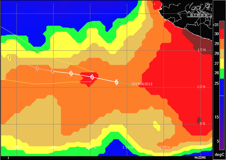
Some northwesterly vertical wind shear continues to affect Barbara,
and this should persist for another 12 h or so. After that, the
cyclone should be in an environment of light shear and over warm sea
surface temperatures through 72 h. The intensity forecast thus
calls for slow development through 12 h and a faster rate of
development thereafter. The various rapid intensification indices
suggest a 40-50 percent chance of rapid intensification from 12-72
h, and if this occurs Barbara could become a major hurricane. Beyond
72 h, the forecast track takes the center over decreasing water
temperatures and into renewed shear, which should cause some
weakening. How much weakening, though, is going to be tied to how
far over the colder water the cyclone moves, with a more northerly
track resulting in a weaker storm then currently forecast.

FORECAST POSITIONS AND MAX WINDS

INIT 30/2100Z 10.9N 112.2W 40 KT 45 MPH
12H 01/0600Z 11.4N 114.7W 45 KT 50 MPH
24H 01/1800Z 11.9N 117.6W 55 KT 65 MPH
36H 02/0600Z 12.2N 120.1W 65 KT 75 MPH
48H 02/1800Z 12.6N 122.2W 75 KT 85 MPH
72H 03/1800Z 14.0N 126.0W 95 KT 110 MPH
96H 04/1800Z 15.5N 129.0W 90 KT 105 MPH
120H 05/1800Z 16.5N 133.0W 80 KT 90 MPH

$$
Forecaster Beven

NNNN
4 likes   
Visit the Caribbean-Central America Weather Thread where you can find at first post web cams,radars
and observations from Caribbean basin members Click Here

User avatar
Kingarabian
S2K Supporter
S2K Supporter
Posts: 15434
Joined: Sat Aug 08, 2009 3:06 am
Location: Honolulu, Hawaii

Re: EPAC: BARBARA - Tropical Storm

#104 Postby Kingarabian » Sun Jun 30, 2019 4:24 pm

UW - CIMSS
ADVANCED DVORAK TECHNIQUE
ADT-Version 9.0
Tropical Cyclone Intensity Algorithm

----- Current Analysis -----
Date : 30 JUN 2019 Time : 205034 UTC
Lat : 10:53:24 N Lon : 112:09:24 W


CI# /Pressure/ Vmax
3.0 /1000.1mb/ 45.0kt


Final T# Adj T# Raw T#
3.0 3.3 3.7
0 likes   
RIP Kobe Bryant

User avatar
Dylan
Professional-Met
Professional-Met
Posts: 337
Age: 29
Joined: Mon May 31, 2010 9:50 am
Location: New Orleans, LA

Re: EPAC: BARBARA - Tropical Storm

#105 Postby Dylan » Sun Jun 30, 2019 5:37 pm

3 likes   
Georges('98), Allison('01), Isidore('02), Lili('02), Frances('04) Ivan('04), Cindy('05), Katrina('05), Rita('05), Gustav('08), Isaac('12), Matthew('16), Harvey('17), Irma('17), Nate ('17), Ida ('21).

User avatar
Kingarabian
S2K Supporter
S2K Supporter
Posts: 15434
Joined: Sat Aug 08, 2009 3:06 am
Location: Honolulu, Hawaii

Re: EPAC: BARBARA - Tropical Storm

#106 Postby Kingarabian » Sun Jun 30, 2019 5:39 pm

3 likes   
RIP Kobe Bryant

User avatar
cycloneye
Admin
Admin
Posts: 139059
Age: 67
Joined: Thu Oct 10, 2002 10:54 am
Location: San Juan, Puerto Rico

Re: EPAC: BARBARA - Tropical Storm

#107 Postby cycloneye » Sun Jun 30, 2019 6:25 pm

Kingarabian,prepare for a great discussion and possible changes on the peak intensity in the next advisory from Stacey.
3 likes   
Visit the Caribbean-Central America Weather Thread where you can find at first post web cams,radars
and observations from Caribbean basin members Click Here

User avatar
Kingarabian
S2K Supporter
S2K Supporter
Posts: 15434
Joined: Sat Aug 08, 2009 3:06 am
Location: Honolulu, Hawaii

Re: EPAC: BARBARA - Tropical Storm

#108 Postby Kingarabian » Sun Jun 30, 2019 6:29 pm

cycloneye wrote:Kingarabian,prepare for a great discussion and possible changes on the peak intensity in the next advisory from Stacey.

Yeah I hope he has the shift because I'm interested in reading what they think will happen. 18z GFS continues to show a considerable difference in the steering pattern compared to the Euro.
Image


Meanwhile Barbara continues to ramp up:
Image

I wonder if explosive RI is in the cards. It's giving me some 2015 Jimena vibes.
4 likes   
RIP Kobe Bryant

Ntxw
Storm2k Moderator
Storm2k Moderator
Posts: 21500
Joined: Wed Oct 21, 2009 6:34 pm
Location: DFW, Texas

Re: EPAC: BARBARA - Tropical Storm

#109 Postby Ntxw » Sun Jun 30, 2019 6:35 pm

I'm definitely getting Jimena 15 vibes too. Thinking 130kts might not be unreasonable for peak now. We'll some spectacular satellite images soon. Plenty of warm water ahead.

UW - CIMSS
ADVANCED DVORAK TECHNIQUE
ADT-Version 9.0
Tropical Cyclone Intensity Algorithm

----- Current Analysis -----
Date : 30 JUN 2019 Time : 225033 UTC
Lat : 11:00:48 N Lon : 112:42:38 W


CI# /Pressure/ Vmax
3.3 / 996.3mb/ 51.0kt


Final T# Adj T# Raw T#
3.3 3.3 3.8

Center Temp : -72.8C Cloud Region Temp : -69.6C

Scene Type : UNIFORM CDO CLOUD REGION


Image
2 likes   
The above post and any post by Ntxw is NOT an official forecast and should not be used as such. It is just the opinion of the poster and may or may not be backed by sound meteorological data. It is NOT endorsed by any professional institution including Storm2k. For official information, please refer to NWS products.

  Help support Storm2K!
Help Support Storm2K

User avatar
cycloneye
Admin
Admin
Posts: 139059
Age: 67
Joined: Thu Oct 10, 2002 10:54 am
Location: San Juan, Puerto Rico

Re: EPAC: BARBARA - Tropical Storm

#110 Postby cycloneye » Sun Jun 30, 2019 7:02 pm

Kingarabian wrote:
cycloneye wrote:Kingarabian,prepare for a great discussion and possible changes on the peak intensity in the next advisory from Stacey.

Yeah I hope he has the shift because I'm interested in reading what they think will happen. 18z GFS continues to show a considerable difference in the steering pattern compared to the Euro.
]https://i.imgur.com/M77mEhZ.gif


Meanwhile Barbara continues to ramp up:
https://i.imgur.com/2GlqGZT.gif

I wonder if explosive RI is in the cards. It's giving me some 2015 Jimena vibes.


It will be him as he made the TWO.Agree on the vibes on Jimena.
1 likes   
Visit the Caribbean-Central America Weather Thread where you can find at first post web cams,radars
and observations from Caribbean basin members Click Here

User avatar
Kingarabian
S2K Supporter
S2K Supporter
Posts: 15434
Joined: Sat Aug 08, 2009 3:06 am
Location: Honolulu, Hawaii

Re: EPAC: BARBARA - Tropical Storm

#111 Postby Kingarabian » Sun Jun 30, 2019 7:12 pm

This SSMIS F16 pass appears to show that Barbara has developed a core. It would be a big step in starting the RI process:
Image
3 likes   
RIP Kobe Bryant

User avatar
cycloneye
Admin
Admin
Posts: 139059
Age: 67
Joined: Thu Oct 10, 2002 10:54 am
Location: San Juan, Puerto Rico

Re: EPAC: BARBARA - Tropical Storm

#112 Postby cycloneye » Sun Jun 30, 2019 7:29 pm

SAB up to 3.0

TXPZ21 KNES 010021
TCSENP

A. 02E (BARBARA)

B. 01/0000Z

C. 10.8N

D. 112.6W

E. THREE/GOES-W

F. T3.0/3.0/D1.5/24HRS

G. IR/EIR/VIS

H. REMARKS...6/10 BANDING RESULTS IN A DT OF 3.0. MET IS 2.5 AND PT IS
3.0. FT IS BASED ON DT.

I. ADDL POSITIONS

NIL


1 likes   
Visit the Caribbean-Central America Weather Thread where you can find at first post web cams,radars
and observations from Caribbean basin members Click Here

Ntxw
Storm2k Moderator
Storm2k Moderator
Posts: 21500
Joined: Wed Oct 21, 2009 6:34 pm
Location: DFW, Texas

Re: EPAC: BARBARA - Tropical Storm

#113 Postby Ntxw » Sun Jun 30, 2019 7:39 pm

That tail.

Image
2 likes   
The above post and any post by Ntxw is NOT an official forecast and should not be used as such. It is just the opinion of the poster and may or may not be backed by sound meteorological data. It is NOT endorsed by any professional institution including Storm2k. For official information, please refer to NWS products.


  Help support Storm2K!

Help Support Storm2K


User avatar
Yellow Evan
Professional-Met
Professional-Met
Posts: 15951
Age: 25
Joined: Fri Jul 15, 2011 12:48 pm
Location: Henderson, Nevada/Honolulu, HI
Contact:

Re: EPAC: BARBARA - Tropical Storm

#114 Postby Yellow Evan » Sun Jun 30, 2019 7:51 pm

This seems promising but I’m unsure if this will get as strong as Jimena did in 2015. This needs a strong inner core that will avoid dry air problems. Also unsure on when exactly this will get blasted apart by the inevitable increase in SW shear but this has potential to be our first long tracker of the year.
1 likes   

User avatar
Kingarabian
S2K Supporter
S2K Supporter
Posts: 15434
Joined: Sat Aug 08, 2009 3:06 am
Location: Honolulu, Hawaii

Re: EPAC: BARBARA - Tropical Storm

#115 Postby Kingarabian » Sun Jun 30, 2019 7:54 pm

Ntxw wrote:That tail.

[url]https://images2.imgbox.com/76/b7/l8pUBVi5_o.gif[/ul]

Ominous...
1 likes   
RIP Kobe Bryant

Chris90
Category 2
Category 2
Posts: 637
Age: 34
Joined: Thu Jun 01, 2017 9:36 pm

Re: EPAC: BARBARA - Tropical Storm

#116 Postby Chris90 » Sun Jun 30, 2019 7:58 pm

Kingarabian wrote:This SSMIS F16 pass appears to show that Barbara has developed a core. It would be a big step in starting the RI process


There's some great banding going on, especially in the southern portions of her circulation, but I think we're still a little ways away from her being ready for RI. Satellite appearance is improving faster than her microwave presentation in my opinion. I still don't see a cyan ring on 37ghz, and the mid levels need work as well. I think there's still some core building to be done, especially in the northern parts of the circulation. When that's done, I think it'll be all systems go for the pressure to drop and winds to spike up.
I think we're still 12-24 hours away from the start of a true RI cycle though.
1 likes   
Solar Aquarian
Lunar Cancerian
:uarrow: Sagittarian

User avatar
TheStormExpert
Category 5
Category 5
Posts: 8487
Age: 30
Joined: Wed Feb 16, 2011 5:38 pm
Location: Palm Beach Gardens, FL

Re: EPAC: BARBARA - Tropical Storm

#117 Postby TheStormExpert » Sun Jun 30, 2019 7:59 pm

And just like that the Eastern Pacific has turned on! :blowup:
1 likes   
The following post is NOT an official forecast and should not be used as such. It is just the opinion of the poster and may or may not be backed by sound meteorological data. It is NOT endorsed by storm2k.org.

plasticup
S2K Supporter
S2K Supporter
Posts: 1295
Joined: Thu Aug 05, 2010 5:49 pm
Location: Bermuda

Re: EPAC: BARBARA - Tropical Storm

#118 Postby plasticup » Sun Jun 30, 2019 8:03 pm


She's a beaut, alright.
0 likes   
Eyes: Emily '86, Dean '89, Felix '95, Gert '99, Fabian '03, Humberto '19, Paulette '20

User avatar
cycloneye
Admin
Admin
Posts: 139059
Age: 67
Joined: Thu Oct 10, 2002 10:54 am
Location: San Juan, Puerto Rico

Re: EPAC: BARBARA - Tropical Storm

#119 Postby cycloneye » Sun Jun 30, 2019 8:04 pm

00z Best Track up to 45 kts.

Location: 10.9°N 113.2°W
Maximum Winds: 45 kt Gusts: N/A
Minimum Central Pressure: 1000 mb
Environmental Pressure: 1008 mb
Radius of Circulation: 150 NM
Radius of Maximum Wind: 30 NM
0 likes   
Visit the Caribbean-Central America Weather Thread where you can find at first post web cams,radars
and observations from Caribbean basin members Click Here

User avatar
Yellow Evan
Professional-Met
Professional-Met
Posts: 15951
Age: 25
Joined: Fri Jul 15, 2011 12:48 pm
Location: Henderson, Nevada/Honolulu, HI
Contact:

Re: EPAC: BARBARA - Tropical Storm

#120 Postby Yellow Evan » Sun Jun 30, 2019 8:09 pm

EP, 02, 2019070100, , BEST, 0, 109N, 1133W, 45, 1000, TS, 34, NEQ, 70, 80, 80, 60, 1008, 150, 30, 0, 0, E, 0, , 0, 0, BARBARA, M, 0, , 0, 0, 0, 0, genesis-num, 008,
0 likes   


Return to “2019”

Who is online

Users browsing this forum: No registered users and 89 guests