ATL: ERIN - Tropical Depression - Discussion

Moderator: S2k Moderators

Message
Author
User avatar
Hurricaneman
Category 5
Category 5
Posts: 7282
Age: 43
Joined: Tue Aug 31, 2004 3:24 pm
Location: central florida

Re: ATL: INVEST 98L - Discussion

#321 Postby Hurricaneman » Sun Aug 25, 2019 10:54 pm

cycloneye wrote:I have not being paying attention to this invest with Dorian as my big interest so my question is I see no activity for many hours in this thread. What happened?

Dorian
1 likes   

Sciencerocks
Category 5
Category 5
Posts: 7286
Age: 38
Joined: Thu Jul 06, 2017 1:51 am

Re: ATL: INVEST 98L - Discussion

#322 Postby Sciencerocks » Mon Aug 26, 2019 2:42 am

Tropical Weather Outlook
NWS National Hurricane Center Miami FL
200 AM EDT Mon Aug 26 2019

For the North Atlantic...Caribbean Sea and the Gulf of Mexico:

The National Hurricane Center is issuing advisories on Tropical
Storm Dorian, located several hundred miles east-southeast of
the Lesser Antilles.

An elongated area of low pressure centered about 280 miles
south-southeast of Cape Hatteras, North Carolina has become a
little better organized this morning
. Environmental conditions
appear conducive for gradual development, and a tropical or
subtropical cyclone is likely to form today or Tuesday while the
system moves slowly northeastward well offshore of the southeastern
United States. Interests along the coasts of South and North
Carolina should continue to monitor the progress of this system. An
Air Force Reserve Hurricane Hunter aircraft is scheduled to
investigate the system later today, if necessary.
* Formation chance through 48 hours...high...80 percent.
* Formation chance through 5 days...high...80 percent.

$$
Forecaster Roberts
1 likes   

User avatar
Kingarabian
S2K Supporter
S2K Supporter
Posts: 15435
Joined: Sat Aug 08, 2009 3:06 am
Location: Honolulu, Hawaii

Re: ATL: INVEST 98L - Discussion

#323 Postby Kingarabian » Mon Aug 26, 2019 4:06 am

cycloneye wrote:I have not being paying attention to this invest with Dorian as my big interest so my question is I see no activity for many hours in this thread. What happened?

Models barely develop it now.
1 likes   
RIP Kobe Bryant

User avatar
Kazmit
Category 5
Category 5
Posts: 1915
Age: 21
Joined: Mon Jul 25, 2016 8:49 am
Location: Williamsburg VA for college, Bermuda otherwise

Re: ATL: INVEST 98L - Discussion

#324 Postby Kazmit » Mon Aug 26, 2019 7:38 am

Why are the chances still 80% on this?
0 likes   
Igor 2010, Sandy 2012, Fay 2014, Gonzalo 2014, Joaquin 2015, Nicole 2016, Humberto 2019

I am only a tropical weather enthusiast. My predictions are not official and may or may not be backed by sound meteorological data. For official information, please refer to the NHC and NWS products.

User avatar
TheAustinMan
Category 4
Category 4
Posts: 997
Age: 24
Joined: Mon Jul 08, 2013 4:26 pm
Location: United States
Contact:

Re: ATL: INVEST 98L - Discussion

#325 Postby TheAustinMan » Mon Aug 26, 2019 7:43 am

Kazmit wrote:Why are the chances still 80% on this?


It's been a bit lumbering with its organization, but generally enjoys some model support for organization throughout today and tomorrow. It'll probably look much better when it separates from the front tomorrow. Part of those chances are based on a possibility of subtropical cyclone development, which can spawn quite the ugly duckling as we've often seen historically.
1 likes   
ImageImageImage
Treat my opinions with a grain of salt. For official information see your local weather service.

User avatar
HurricaneEnzo
Category 2
Category 2
Posts: 723
Joined: Wed Mar 14, 2018 12:18 pm
Location: Newport, NC (Hurricane Alley)

Re: ATL: INVEST 98L - Discussion

#326 Postby HurricaneEnzo » Mon Aug 26, 2019 11:07 am

Kazmit wrote:Why are the chances still 80% on this?


They are probably more focused on Dorian at the moment. Still a chance to develop but probably not 80%
0 likes   
Bertha 96' - Fran 96' - Bonnie 98' - Dennis 99' - Floyd 99' - Isabel 03' - Alex 04' - Ophelia 05' - Irene 11' - Arthur 14' - Matthew 16' - Florence 18' - Dorian 19' - Isaias 20' (countless other tropical storms and Hurricane swipes)

I am not a Professional Met just an enthusiast. Get your weather forecasts from the Pros!

User avatar
northjaxpro
S2K Supporter
S2K Supporter
Posts: 8900
Joined: Mon Sep 27, 2010 11:21 am
Location: Jacksonville, FL

Re: ATL: INVEST 98L - Discussion

#327 Postby northjaxpro » Mon Aug 26, 2019 11:24 am

98L or whatever becomes of this feature will still play a very key factor in the whole picture regarding Dorian.

The BIG question will be how much of a weakness it will leave in its wake once it develops and moves out.before ridgjng builds back across the SW North Atantic basin before the end of the week?

How much farther poleward Dorian will get before turning back w/ w/nw? Lots to watch!!
0 likes   
NEVER, EVER SAY NEVER in the tropics and weather in general, and most importantly, with life itself!!

________________________________________________________________________________________

Fay 2008 Beryl 2012 Debby 2012 Colin 2016 Hermine 2016 Julia 2016 Matthew 2016 Irma 2017 Dorian 2019

zhukm29
Tropical Storm
Tropical Storm
Posts: 219
Joined: Tue Aug 28, 2018 2:37 pm

Re: ATL: INVEST 98L - Discussion

#328 Postby zhukm29 » Mon Aug 26, 2019 11:29 am

Recent ASCAT pass:

Image
0 likes   

User avatar
northjaxpro
S2K Supporter
S2K Supporter
Posts: 8900
Joined: Mon Sep 27, 2010 11:21 am
Location: Jacksonville, FL

Re: ATL: INVEST 98L - Discussion

#329 Postby northjaxpro » Mon Aug 26, 2019 11:53 am

Looking at that ASCAT, We have a closed low level circulation. No doubt to me this is a TD. even likely Erin to be to the point.
1 likes   
NEVER, EVER SAY NEVER in the tropics and weather in general, and most importantly, with life itself!!

________________________________________________________________________________________

Fay 2008 Beryl 2012 Debby 2012 Colin 2016 Hermine 2016 Julia 2016 Matthew 2016 Irma 2017 Dorian 2019

User avatar
Hammy
Category 5
Category 5
Posts: 5594
Age: 40
Joined: Fri May 25, 2012 5:25 pm
Contact:

Re: ATL: INVEST 98L - Discussion

#330 Postby Hammy » Mon Aug 26, 2019 11:55 am

northjaxpro wrote:Looking at that ASCAT, We have a closed low level circulation. No doubt to me this is a TD. even likely Erin to be to the point.


Probably waiting to make sure convection persists.
1 likes   
The above post is not official and should not be used as such. It is the opinion of the poster and may or may not be backed by sound meteorological data. It is not endorsed by any professional institution or storm2k.org. For official information, please refer to the NHC and NWS products.

zhukm29
Tropical Storm
Tropical Storm
Posts: 219
Joined: Tue Aug 28, 2018 2:37 pm

Re: ATL: INVEST 98L - Discussion

#331 Postby zhukm29 » Mon Aug 26, 2019 12:37 pm

New ASCAT pass showing a closed low with 35kt winds. Erin may be classifiable now.

Image
2 likes   

User avatar
northjaxpro
S2K Supporter
S2K Supporter
Posts: 8900
Joined: Mon Sep 27, 2010 11:21 am
Location: Jacksonville, FL

Re: ATL: INVEST 98L - Discussion

#332 Postby northjaxpro » Mon Aug 26, 2019 12:39 pm

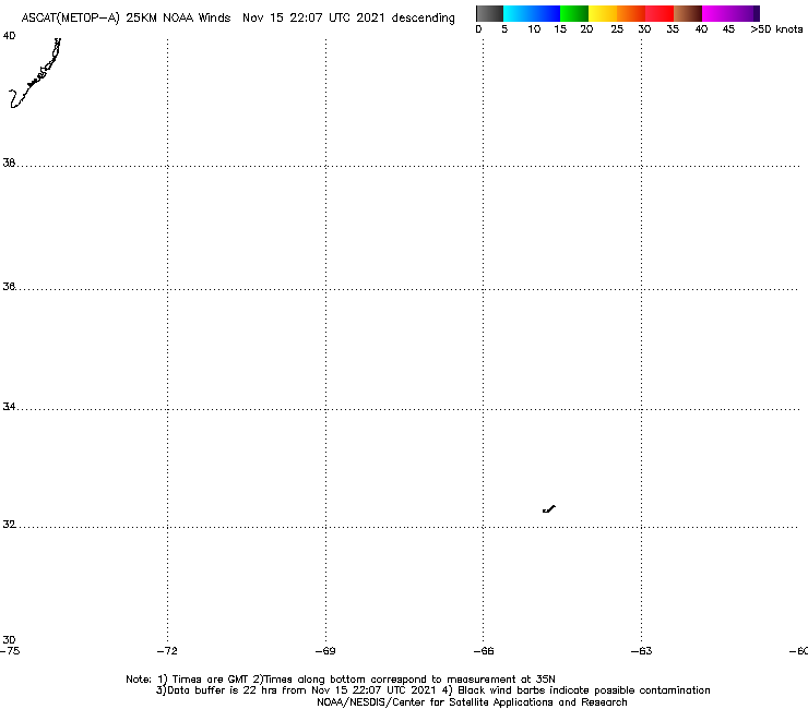
zhukm29 wrote:New ASCAT pass showing a closed low with 35kt winds. Erin may be classifiable now.

https://manati.star.nesdis.noaa.gov/ascat_images/cur_25km_META/zooms/WMBds86.png


I agree with this from my earlier post on the ASCAT pass on the previous page
0 likes   
NEVER, EVER SAY NEVER in the tropics and weather in general, and most importantly, with life itself!!

________________________________________________________________________________________

Fay 2008 Beryl 2012 Debby 2012 Colin 2016 Hermine 2016 Julia 2016 Matthew 2016 Irma 2017 Dorian 2019

zhukm29
Tropical Storm
Tropical Storm
Posts: 219
Joined: Tue Aug 28, 2018 2:37 pm

Re: ATL: INVEST 98L - Discussion

#333 Postby zhukm29 » Mon Aug 26, 2019 12:43 pm

I concur. 98L surely took its time to develop, but it has finally made it to the point of being named. Now it's just a waiting game to see whether the NHC pulls the trigger.
2 likes   

User avatar
DioBrando
Category 4
Category 4
Posts: 917
Age: 27
Joined: Sun Aug 12, 2018 12:45 pm

Re: ATL: INVEST 98L - Discussion

#334 Postby DioBrando » Mon Aug 26, 2019 1:03 pm

zhukm29 wrote:I concur. 98L surely took its time to develop, but it has finally made it to the point of being named. Now it's just a waiting game to see whether the NHC pulls the trigger.

Wait what it's confirmed to be Erin???
0 likes   
blonde stacey (xe/xem/xir)

User avatar
AnnularCane
S2K Supporter
S2K Supporter
Posts: 2635
Joined: Thu Jun 08, 2006 9:18 am
Location: Wytheville, VA

Re: ATL: INVEST 98L - Discussion

#335 Postby AnnularCane » Mon Aug 26, 2019 1:18 pm

DioBrando wrote:
zhukm29 wrote:I concur. 98L surely took its time to develop, but it has finally made it to the point of being named. Now it's just a waiting game to see whether the NHC pulls the trigger.

Wait what it's confirmed to be Erin???


Still 98L as of now.
1 likes   

zhukm29
Tropical Storm
Tropical Storm
Posts: 219
Joined: Tue Aug 28, 2018 2:37 pm

Re: ATL: INVEST 98L - Discussion

#336 Postby zhukm29 » Mon Aug 26, 2019 1:19 pm

It hasn't been named yet. Although it could be named since the ASCAT pass supports an upgrade, the NHC is likely waiting for convection to persist before giving 98L an official name. They did update the chances to 90/90 at 2 PM, so the upgrade is likely to come tonight or tomorrow in my opinion.
0 likes   

User avatar
DioBrando
Category 4
Category 4
Posts: 917
Age: 27
Joined: Sun Aug 12, 2018 12:45 pm

Re: ATL: INVEST 98L - Discussion

#337 Postby DioBrando » Mon Aug 26, 2019 1:37 pm

aight
0 likes   
blonde stacey (xe/xem/xir)

User avatar
Hurricaneman
Category 5
Category 5
Posts: 7282
Age: 43
Joined: Tue Aug 31, 2004 3:24 pm
Location: central florida

Re: ATL: INVEST 98L - Discussion

#338 Postby Hurricaneman » Mon Aug 26, 2019 2:00 pm

zhukm29 wrote:It hasn't been named yet. Although it could be named since the ASCAT pass supports an upgrade, the NHC is likely waiting for convection to persist before giving 98L an official name. They did update the chances to 90/90 at 2 PM, so the upgrade is likely to come tonight or tomorrow in my opinion.

Might become a mid grade tropical storm but this system may have bigger implications for Dorian as the stronger this gets the less greater Antilles impact from Dorian but Florida becomes a problem so this will probably be Erin but could have indirect effects on Florida due to leaving a temporary weakness for Dorian
1 likes   

OuterBanker
S2K Supporter
S2K Supporter
Posts: 1704
Joined: Wed Feb 26, 2003 10:53 am
Location: Nags Head, NC
Contact:

Re: ATL: INVEST 98L - Discussion

#339 Postby OuterBanker » Mon Aug 26, 2019 2:15 pm

Will 98l (soon to be Erin) influence Dorian's path.
Now back to 90%. What is odd is that it seems to have decoupled from the front. It looks stationary now and has a rather large well defined llc. If that is what the NHC is referring to I don't see how recon got the readings they did. It just looks like a naked swirl.
No landfall anywhere of course, but I wonder if it will pull Dorian more pole ward.
0 likes   

User avatar
northjaxpro
S2K Supporter
S2K Supporter
Posts: 8900
Joined: Mon Sep 27, 2010 11:21 am
Location: Jacksonville, FL

Re: ATL: INVEST 98L - Discussion

#340 Postby northjaxpro » Mon Aug 26, 2019 2:20 pm

OuterBanker wrote:Will 98l (soon to be Erin) influence Dorian's path.
Now back to 90%. What is odd is that it seems to have decoupled from the front. It looks stationary now and has a rather large well defined llc. If that is what the NHC is referring to I don't see how recon got the readings they did. It just looks like a naked swirl.
No landfall anywhere of course, but I wonder if it will pull Dorian more pole ward.


The weakness, which will be very briefly in place in soon to be Erin's wake, and would allow Dorian to move poleward enough to miss Hispaniola , but the ridge will build back in within the next 96 hours or so from now, and force Dorian to move west or west/northwest (depending on ridge orientation) toward Florida.

Ridge orientation will determine if it will be a greater threat to South Florida or Central Florida concerning potential direct landfall.
0 likes   
NEVER, EVER SAY NEVER in the tropics and weather in general, and most importantly, with life itself!!

________________________________________________________________________________________

Fay 2008 Beryl 2012 Debby 2012 Colin 2016 Hermine 2016 Julia 2016 Matthew 2016 Irma 2017 Dorian 2019


Return to “2019”

Who is online

Users browsing this forum: No registered users and 89 guests