https://twitter.com/Phinernie/status/1164912621327462400
ATL: DORIAN - Post-Tropical - Discussion
Moderator: S2k Moderators
-
alienstorm

- Category 1

- Posts: 496
- Joined: Tue Jul 31, 2007 1:29 pm
- Location: Miami Fla western suburb
Re: ATL: INVEST 99L - Discussion
1 likes
Personal Forecast Disclaimer:The posts in this forum are NOT official forecast and should not be used as such. They are just the opinion of the poster and may or may not be backed by sound meteorological data. They are NOT endorsed by any professional institution or storm2k.org. For official information, please refer to the NHC and NWS products.

Re: ATL: INVEST 99L - Discussion
This is definitely ramping up quickly. With that ASCAT pass, I wouldn't be surprised if gets classified sooner than expected. Dry air would mean less the faster this develops, and shear is low. This could even steal the name Dorian before 98L.
0 likes
-
Hypercane_Kyle

- Category 5

- Posts: 2900
- Joined: Sat Mar 07, 2015 7:58 pm
- Location: Cape Canaveral, FL
Re: ATL: INVEST 99L - Discussion
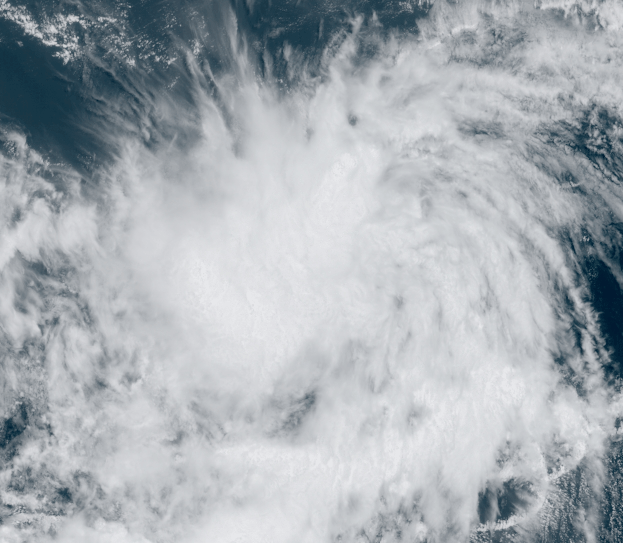
alienstorm wrote:https://twitter.com/Phinernie/status/1164912621327462400
Looks somewhat elongated to me and still embedded within the ITCZ.
0 likes
My posts are my own personal opinion, defer to the National Hurricane Center (NHC) and other NOAA products for decision making during hurricane season.
Re: ATL: INVEST 99L - Discussion
This one is rather unique in it being projected to move at no more than about 3 degrees west in longitude per day in its WNW averaged track. For the current position (central MDR) in late August, that is unusually slow. I’d say that an average late August to early Sep WNW TC track in that area is probably close to double that or about 5-6 degrees west per day while moving WNW. Look back at historical storm tracks to verify. I’d say that a slow WNW central MDR movement like this is closer to the average much later in the season, say, in early Oct. when things tend to slow down on average in that area. If I get time, I’ll look at old maps to see if I can find slower late August movers in this area and see what they ultimately did.
Any thoughts about this?
Any thoughts about this?
1 likes
Personal Forecast Disclaimer:
The posts in this forum are NOT official forecasts and should not be used as such. They are just the opinion of the poster and may or may not be backed by sound meteorological data. They are NOT endorsed by any professional institution or storm2k.org. For official information, please refer to the NHC and NWS products.
The posts in this forum are NOT official forecasts and should not be used as such. They are just the opinion of the poster and may or may not be backed by sound meteorological data. They are NOT endorsed by any professional institution or storm2k.org. For official information, please refer to the NHC and NWS products.
-
NotSparta

- Professional-Met

- Posts: 1652
- Age: 22
- Joined: Fri Aug 18, 2017 8:24 am
- Location: Naples, FL
- Contact:
Re: ATL: INVEST 99L - Discussion
It's a 99L, it won't form until September
4 likes
This post was probably an opinion of mine, and in no way is official. Please refer to http://www.hurricanes.gov for official tropical analysis and advisories.
My website, with lots of tropical wx graphics, including satellite and recon: http://cyclonicwx.com
My website, with lots of tropical wx graphics, including satellite and recon: http://cyclonicwx.com


Re: ATL: INVEST 99L - Discussion
LarryWx wrote:This one is rather unique in it being projected to move at no more than about 3 degrees west in longitude per day in its WNW averaged track. For the current position (central MDR) in late August, that is unusually slow. I’d say that an average late August to early Sep WNW TC track in that area is probably close to double that or about 5-6 degrees west per day while moving WNW. Look back at historical storm tracks to verify. I’d say that a slow WNW central MDR movement like this is closer to the average much later in the season, say, in early Oct. when things tend to slow down on average in that area. If I get time, I’ll look at old maps to see if I can find slower late August movers in this area and see what they ultimately did.
Any thoughts about this?
The Bermuda high is forecast to break down as a result of 98L / a passing trough in SE Canada as well as an ULL forming well to the north of 99L. The net steering flow remains weakly westward since no big trough is swinging down into the western Atlantic anytime soon. So I guess that would match up with later fall generally when you have disruption of the Bermuda / Azores High.
2 likes
-
TheStormExpert

- Category 5
- Posts: 8487
- Age: 30
- Joined: Wed Feb 16, 2011 5:38 pm
- Location: Palm Beach Gardens, FL
Re: ATL: INVEST 99L - Discussion
NotSparta wrote:
It's a 99L, it won't form until September
Wasn’t pre-Hermime (2016) the dreaded 99L that lasted forever?
7 likes
The following post is NOT an official forecast and should not be used as such. It is just the opinion of the poster and may or may not be backed by sound meteorological data. It is NOT endorsed by storm2k.org.
-
AnnularCane

- S2K Supporter

- Posts: 2637
- Joined: Thu Jun 08, 2006 9:18 am
- Location: Wytheville, VA

Re: ATL: INVEST 99L - Discussion
0 likes
Very useful information on the Dvorak Technique --
https://severe.worldweather.wmo.int/TCF ... kBeven.pdf
https://severe.worldweather.wmo.int/TCF ... kBeven.pdf
-
NotSparta
- Professional-Met
- Posts: 1652
- Age: 22
- Joined: Fri Aug 18, 2017 8:24 am
- Location: Naples, FL
- Contact:
Re: ATL: INVEST 99L - Discussion
TheStormExpert wrote:NotSparta wrote:
It's a 99L, it won't form until September
Wasn’t pre-Hermime (2016) the dreaded 99L that lasted forever?
Yes, then was Gert in 2017
0 likes
This post was probably an opinion of mine, and in no way is official. Please refer to http://www.hurricanes.gov for official tropical analysis and advisories.
My website, with lots of tropical wx graphics, including satellite and recon: http://cyclonicwx.com
My website, with lots of tropical wx graphics, including satellite and recon: http://cyclonicwx.com
-
PTrackerLA

- Category 5
- Posts: 5248
- Age: 40
- Joined: Thu Oct 10, 2002 8:40 pm
- Location: Lafayette, LA
Re: ATL: INVEST 99L - Discussion
Wow the satellite appearance of this one has caught me by surprise this morning. The basin is definitely coming alive before our eyes.
3 likes
-
dexterlabio
- Category 5
- Posts: 3407
- Joined: Sat Oct 24, 2009 11:50 pm
Re: ATL: INVEST 99L - Discussion
I feel a little iffy about this. At least it appears that this already got many people's attention.
0 likes
Personal Forecast Disclaimer:
The posts in this forum are NOT official forecast and should not be used as such. They are just the opinion of the poster and may or may not be backed by sound meteorological data. They are NOT endorsed by any professional institution or storm2k.org. For official information, please refer to the NHC and NWS products.
The posts in this forum are NOT official forecast and should not be used as such. They are just the opinion of the poster and may or may not be backed by sound meteorological data. They are NOT endorsed by any professional institution or storm2k.org. For official information, please refer to the NHC and NWS products.
-
northjaxpro

- S2K Supporter
- Posts: 8900
- Joined: Mon Sep 27, 2010 11:21 am
- Location: Jacksonville, FL
Re: ATL: INVEST 99L - Discussion
Based on the ASCAT, I am of the belief that this is already a closed Low Level Cyclone. This is a TD in my educated analysis now.
3 likes
NEVER, EVER SAY NEVER in the tropics and weather in general, and most importantly, with life itself!!
________________________________________________________________________________________
Fay 2008 Beryl 2012 Debby 2012 Colin 2016 Hermine 2016 Julia 2016 Matthew 2016 Irma 2017 Dorian 2019
________________________________________________________________________________________
Fay 2008 Beryl 2012 Debby 2012 Colin 2016 Hermine 2016 Julia 2016 Matthew 2016 Irma 2017 Dorian 2019

-
TheStormExpert
- Category 5
- Posts: 8487
- Age: 30
- Joined: Wed Feb 16, 2011 5:38 pm
- Location: Palm Beach Gardens, FL
Re: ATL: INVEST 99L - Discussion
This is very likely thanks to the kelvin wave that just passed the Atlantic, will likely struggle at some point in the future especially as it detaches from the ITCZ.
3 likes
The following post is NOT an official forecast and should not be used as such. It is just the opinion of the poster and may or may not be backed by sound meteorological data. It is NOT endorsed by storm2k.org.
-
Kazmit

- Category 5
- Posts: 1915
- Age: 21
- Joined: Mon Jul 25, 2016 8:49 am
- Location: Williamsburg VA for college, Bermuda otherwise
Re: ATL: INVEST 99L - Discussion
Who has a guess of which invest will become Dorian first?
2 likes
Igor 2010, Sandy 2012, Fay 2014, Gonzalo 2014, Joaquin 2015, Nicole 2016, Humberto 2019
I am only a tropical weather enthusiast. My predictions are not official and may or may not be backed by sound meteorological data. For official information, please refer to the NHC and NWS products.
I am only a tropical weather enthusiast. My predictions are not official and may or may not be backed by sound meteorological data. For official information, please refer to the NHC and NWS products.
Re: ATL: INVEST 99L - Discussion
Calendar + this disturbance + 98L likely = the end of season cancel season and the real meat and potatoes of whatever 2019 is going to throw at us. This one looks decent right now but I certainly wouldn't blame the NHC for being a bit reticent to pull the trigger owing to the location and sometimes transient nature of formative disturbances. Nevertheless...this is likely a go at some point and if it ends up near or north of the greater Antilles it will be in that subtropical hot zone many of us have been expecting to ultimately be productive this season. Things are getting a lot less boring..
4 likes
-
northjaxpro
- S2K Supporter
- Posts: 8900
- Joined: Mon Sep 27, 2010 11:21 am
- Location: Jacksonville, FL
Re: ATL: INVEST 99L - Discussion
Kazmit wrote:Who has a guess of which invest will become Dorian first?
This is actually going to be a close one to gauge. 99L imo is already a TD and is well on its to becoming a TS. May be one this weekend.
98L will probably become a TD in the next 24 hours.
This will be a close one. I will hedge a guess 99L will become Dorian quicker than 98L. Its more organized and developed than 98L as well currently. Make this a separate thread of its own.
5 likes
NEVER, EVER SAY NEVER in the tropics and weather in general, and most importantly, with life itself!!
________________________________________________________________________________________
Fay 2008 Beryl 2012 Debby 2012 Colin 2016 Hermine 2016 Julia 2016 Matthew 2016 Irma 2017 Dorian 2019
________________________________________________________________________________________
Fay 2008 Beryl 2012 Debby 2012 Colin 2016 Hermine 2016 Julia 2016 Matthew 2016 Irma 2017 Dorian 2019
-
tropicwatch

- Category 5
- Posts: 3205
- Age: 60
- Joined: Sat Jun 02, 2007 10:01 am
- Location: Panama City Florida
- Contact:
Re: ATL: INVEST 99L - Discussion
It is definitely getting that look.
6 likes
Tropicwatch
Agnes 72', Eloise 75, Elena 85', Kate 85', Charley 86', Florence 88', Beryl 94', Dean 95', Erin 95', Opal 95', Earl 98', Georges 98', Ivan 2004', Arlene 2005', Dennis 2005', Ida 2009' Debby 2012' Irma 2017' Michael 2018'
Agnes 72', Eloise 75, Elena 85', Kate 85', Charley 86', Florence 88', Beryl 94', Dean 95', Erin 95', Opal 95', Earl 98', Georges 98', Ivan 2004', Arlene 2005', Dennis 2005', Ida 2009' Debby 2012' Irma 2017' Michael 2018'
-
tarheelprogrammer

- S2K Supporter
- Posts: 1793
- Joined: Mon Mar 28, 2016 9:25 pm
- Location: Raleigh, NC area (Garner, NC)
Re: ATL: INVEST 99L - Discussion
It looks like it is already a TS to me.
2 likes
My posts are not official forecasts. They are just my opinion and may or may not be backed by sound meteorological data. They are NOT endorsed by any professional institution or storm2k.org. For official information, please refer to the NHC and NWS products.
Who is online
Users browsing this forum: No registered users and 55 guests