ATL: FERNAND - Remnants - Discussion
Moderator: S2k Moderators
-
lrak

- S2K Supporter

- Posts: 1770
- Age: 57
- Joined: Thu Jun 21, 2007 2:48 pm
- Location: Corpus Christi, TX
Re: ATL: INVEST 93L - Discussion
https://www.ndbc.noaa.gov/station_page.php?station=42055&uom=E&tz=EST nice pressure drop in the BOC!
0 likes
AKA karl
Also
Personal Forecast Disclaimer:
My posts on this forum are NOT official forecast and should not be used as such. My posts are my basic observations and are definitely not backed by any "well some" meteorological knowledge. For official information, please refer to the NHC and NWS products.
Also
Personal Forecast Disclaimer:
My posts on this forum are NOT official forecast and should not be used as such. My posts are my basic observations and are definitely not backed by any "well some" meteorological knowledge. For official information, please refer to the NHC and NWS products.
Re: ATL: INVEST 93L - Discussion
A near TC in the GOM in September and things are quiet in here.
But a SAL choked wave in July gets 100 pages. Gotta love S2K sometimes.
But a SAL choked wave in July gets 100 pages. Gotta love S2K sometimes.
22 likes
-
AnnularCane

- S2K Supporter
- Posts: 2634
- Joined: Thu Jun 08, 2006 9:18 am
- Location: Wytheville, VA
Re: ATL: INVEST 93L - Discussion
RL3AO wrote:A near TC in the GOM in September and things are quiet in here.
But a SAL choked wave in July gets 100 pages. Gotta love S2K sometimes.
We didn't have Dorian back then!
2 likes
-
lrak
- S2K Supporter
- Posts: 1770
- Age: 57
- Joined: Thu Jun 21, 2007 2:48 pm
- Location: Corpus Christi, TX
Re: ATL: INVEST 93L - Discussion
https://www.ndbc.noaa.gov/station_page.php?station=42002
42002 buoy
38 mph too much going on...I think a budget increase is due to NOAA. Looks like a TD by now?
42002 buoy
38 mph
too much going on...I think a budget increase is due to NOAA. Looks like a TD by now?
1 likes
AKA karl
Also
Personal Forecast Disclaimer:
My posts on this forum are NOT official forecast and should not be used as such. My posts are my basic observations and are definitely not backed by any "well some" meteorological knowledge. For official information, please refer to the NHC and NWS products.
Also
Personal Forecast Disclaimer:
My posts on this forum are NOT official forecast and should not be used as such. My posts are my basic observations and are definitely not backed by any "well some" meteorological knowledge. For official information, please refer to the NHC and NWS products.

Re: ATL: INVEST 93L - Discussion
I would go as far as a TS but obviously have to wait for the plane to get in there. Plenty of warm water in GOM to feed anything even something the size of D...IMO
0 likes
-
lrak
- S2K Supporter
- Posts: 1770
- Age: 57
- Joined: Thu Jun 21, 2007 2:48 pm
- Location: Corpus Christi, TX
Re: ATL: INVEST 93L - Discussion
ROCK wrote:I would go as far as a TS but obviously have to wait for the plane to get in there. Plenty of warm water in GOM to feed anything even something the size of D...IMO
The water vapor loop looks like Dorian is being pushed down and 93L is allowed to move a little more north than expected?
0 likes
AKA karl
Also
Personal Forecast Disclaimer:
My posts on this forum are NOT official forecast and should not be used as such. My posts are my basic observations and are definitely not backed by any "well some" meteorological knowledge. For official information, please refer to the NHC and NWS products.
Also
Personal Forecast Disclaimer:
My posts on this forum are NOT official forecast and should not be used as such. My posts are my basic observations and are definitely not backed by any "well some" meteorological knowledge. For official information, please refer to the NHC and NWS products.


Re: ATL: INVEST 93L - Discussion
lrak wrote:ROCK wrote:I would go as far as a TS but obviously have to wait for the plane to get in there. Plenty of warm water in GOM to feed anything even something the size of D...IMO
The water vapor loop looks like Dorian is being pushed down and 93L is allowed to move a little more north than expected?
Link to this view, please.
0 likes
-
lrak
- S2K Supporter
- Posts: 1770
- Age: 57
- Joined: Thu Jun 21, 2007 2:48 pm
- Location: Corpus Christi, TX
Re: ATL: INVEST 93L - Discussion
birdwomn wrote:lrak wrote:ROCK wrote:I would go as far as a TS but obviously have to wait for the plane to get in there. Plenty of warm water in GOM to feed anything even something the size of D...IMO
The water vapor loop looks like Dorian is being pushed down and 93L is allowed to move a little more north than expected?
Not sure of the NASA satellite loops https://weather.msfc.nasa.gov/GOES/ the color one is the one I always looks at....
1 likes
AKA karl
Also
Personal Forecast Disclaimer:
My posts on this forum are NOT official forecast and should not be used as such. My posts are my basic observations and are definitely not backed by any "well some" meteorological knowledge. For official information, please refer to the NHC and NWS products.
Also
Personal Forecast Disclaimer:
My posts on this forum are NOT official forecast and should not be used as such. My posts are my basic observations and are definitely not backed by any "well some" meteorological knowledge. For official information, please refer to the NHC and NWS products.
Re: ATL: INVEST 93L - Discussion
lrak wrote:ROCK wrote:I would go as far as a TS but obviously have to wait for the plane to get in there. Plenty of warm water in GOM to feed anything even something the size of D...IMO
The water vapor loop looks like Dorian is being pushed down and 93L is allowed to move a little more north than expected?
I haven’t done a deep dive into 93 yet but it wouldn’t surprise me. Most models think straight shot into MX thou. I need some recon data tomorrow please...
0 likes
-
lrak
- S2K Supporter
- Posts: 1770
- Age: 57
- Joined: Thu Jun 21, 2007 2:48 pm
- Location: Corpus Christi, TX
Re: ATL: INVEST 93L - Discussion
Bump...Dorian isn't going anywhere fast....need a little on this thread.
0 likes
AKA karl
Also
Personal Forecast Disclaimer:
My posts on this forum are NOT official forecast and should not be used as such. My posts are my basic observations and are definitely not backed by any "well some" meteorological knowledge. For official information, please refer to the NHC and NWS products.
Also
Personal Forecast Disclaimer:
My posts on this forum are NOT official forecast and should not be used as such. My posts are my basic observations and are definitely not backed by any "well some" meteorological knowledge. For official information, please refer to the NHC and NWS products.

-
lrak
- S2K Supporter
- Posts: 1770
- Age: 57
- Joined: Thu Jun 21, 2007 2:48 pm
- Location: Corpus Christi, TX
Re: ATL: INVEST 93L - Discussion
Bigwhitey wrote:Headed to Mexico for a taco
Nein!!!
https://www.youtube.com/watch?v=bjKzJIu56oU
At least watch a little 3 min of your time, love this place.
Hopefully the video will attract
visitors.
0 likes
AKA karl
Also
Personal Forecast Disclaimer:
My posts on this forum are NOT official forecast and should not be used as such. My posts are my basic observations and are definitely not backed by any "well some" meteorological knowledge. For official information, please refer to the NHC and NWS products.
Also
Personal Forecast Disclaimer:
My posts on this forum are NOT official forecast and should not be used as such. My posts are my basic observations and are definitely not backed by any "well some" meteorological knowledge. For official information, please refer to the NHC and NWS products.
-
wxman57

- Moderator-Pro Met

- Posts: 22480
- Age: 66
- Joined: Sat Jun 21, 2003 8:06 pm
- Location: Houston, TX (southwest)
Re: ATL: INVEST 93L - Discussion
I don't think there is a closed circulation. Thunderstorms produce 35-40+ kt winds out there quite often. I started advisories on it this afternoon. Will likely move inland north of Tampico within 72 hrs. Could become a weak TS. Possibly a little rain for south TX if you're lucky down there.
5 likes
-
CYCLONE MIKE
- Category 5

- Posts: 2183
- Joined: Tue Aug 31, 2004 6:04 pm
- Location: Gonzales, LA
Re: ATL: INVEST 93L - Discussion
RL3AO wrote:A near TC in the GOM in September and things are quiet in here.
But a SAL choked wave in July gets 100 pages. Gotta love S2K sometimes.
Because in this case it is so cut and dry on where it goes regardless of development or not. Though I am not one to post about a dry wave in July
0 likes


Re: ATL: INVEST 93L - Discussion
Agreed. Maybe the RGV gets some rain as well. We have like zero percent chance of rain for a week and mid and upper 90s. The CONUS ridge will keep this far south. Gonna be hot in the SE and Texas for a while*. But apparently this is likely to become a named storm. It’s only got a few days, but NHC has it at 60%/70%.
* so the heat and lack of rain will likely erase any of Barry’s or that last invest’s cooling in the N and NW Gulf. JMA model likes this burst and says we probably get another 2 or 3 named storms in the next week or so. Then we will have to see after that.
* so the heat and lack of rain will likely erase any of Barry’s or that last invest’s cooling in the N and NW Gulf. JMA model likes this burst and says we probably get another 2 or 3 named storms in the next week or so. Then we will have to see after that.
0 likes

Re: ATL: INVEST 93L - Discussion
Probably goes straight to TS if this continues.
Conditions at 42002 as of
(1:50 am CDT)
0650 GMT on 09/03/2019:
Unit of Measure: Time Zone:
Click on the graph icon in the table below to see a time series plot of the last five days of that observation.
5-day plot - Wind Direction Wind Direction (WDIR): E ( 100 deg true )
5-day plot - Wind Speed Wind Speed (WSPD): 27.2 kts
5-day plot - Wind Gust Wind Gust (GST): 36.9 kts
5-day plot - Wave Height Wave Height (WVHT): 7.2 ft
5-day plot - Dominant Wave Period Dominant Wave Period (DPD): 8 sec
5-day plot - Average Period Average Period (APD): 5.5 sec
5-day plot - Mean Wave Direction Mean Wave Direction (MWD): E ( 87 deg true )
5-day plot - Atmospheric Pressure Atmospheric Pressure (PRES): 29.82 in
5-day plot - Pressure Tendency Pressure Tendency (PTDY): -0.02 in ( Falling )
5-day plot - Air Temperature Air Temperature (ATMP): 78.6 °F
5-day plot - Water Temperature Water Temperature (WTMP): 86.2 °F
5-day plot - Wind Speed at 10 Meters Wind Speed at 10 meters (WSPD10M): 29.1 kts
5-day plot - Wind Speed at 10 Meters Wind Speed at 20 meters (WSPD20M): 31.1 kts
5-day plot - Wind Speed, Wind Gust and Atmospheric Pressure Combined plot of Wind Speed, Gust, and Air Pressure
0 likes
The following post is NOT an official forecast and should not be used as such. It is just the opinion of the poster and may or may not be backed by sound meteorological data. It is NOT endorsed by any professional institution including storm2k.org For Official Information please refer to the NHC and NWS products.
Re: ATL: INVEST 93L - Discussion
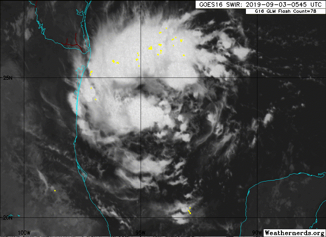
POTENTIAL TROPICAL CYCLONE SEVEN FORECAST/ADVISORY NUMBER 1
NWS NATIONAL HURRICANE CENTER MIAMI FL AL072019
0900 UTC TUE SEP 03 2019
CHANGES IN WATCHES AND WARNINGS WITH THIS ADVISORY...
THE GOVERNMENT OF MEXICO HAS ISSUED A TROPICAL STORM WARNING FROM
LA PESCA NORTHWARD TO BARRA EL MEZQUITAL.
SUMMARY OF WATCHES AND WARNINGS IN EFFECT...
A TROPICAL STORM WARNING IS IN EFFECT FOR...
* LA PESCA TO BARRA EL MEZQUITAL
A TROPICAL STORM WARNING MEANS THAT TROPICAL STORM CONDITIONS ARE
EXPECTED SOMEWHERE WITHIN THE WARNING AREA WITHIN 36 HOURS.
POTENTIAL TROP CYCLONE CENTER LOCATED NEAR 23.5N 94.3W AT 03/0900Z
POSITION ACCURATE WITHIN 30 NM
PRESENT MOVEMENT TOWARD THE WEST OR 260 DEGREES AT 6 KT
ESTIMATED MINIMUM CENTRAL PRESSURE 1006 MB
MAX SUSTAINED WINDS 30 KT WITH GUSTS TO 40 KT.
WINDS AND SEAS VARY GREATLY IN EACH QUADRANT. RADII IN NAUTICAL
MILES ARE THE LARGEST RADII EXPECTED ANYWHERE IN THAT QUADRANT.
REPEAT...CENTER LOCATED NEAR 23.5N 94.3W AT 03/0900Z
AT 03/0600Z CENTER WAS LOCATED NEAR 23.6N 94.0W
FORECAST VALID 03/1800Z 23.4N 95.2W
MAX WIND 30 KT...GUSTS 40 KT.
FORECAST VALID 04/0600Z 23.4N 96.3W
MAX WIND 35 KT...GUSTS 45 KT.
34 KT... 50NE 0SE 0SW 50NW.
FORECAST VALID 04/1800Z 23.7N 97.1W
MAX WIND 40 KT...GUSTS 50 KT.
34 KT... 60NE 40SE 0SW 60NW.
FORECAST VALID 05/0600Z 24.3N 98.2W...INLAND
MAX WIND 30 KT...GUSTS 40 KT.
FORECAST VALID 06/0600Z...DISSIPATED
REQUEST FOR 3 HOURLY SHIP REPORTS WITHIN 300 MILES OF 23.5N 94.3W
INTERMEDIATE PUBLIC ADVISORY...WTNT32 KNHC/MIATCPAT2...AT 03/1200Z
NEXT ADVISORY AT 03/1500Z
$$
FORECASTER STEWART
0 likes
-
Sciencerocks
- Category 5
- Posts: 7286
- Age: 38
- Joined: Thu Jul 06, 2017 1:51 am
-
South Texas Storms

- Professional-Met

- Posts: 4005
- Joined: Thu Jun 24, 2010 12:28 am
- Location: Houston, TX
Re: ATL: Seven - Potential Tropical Cyclone
This system is coming together nicely. Likely to become a TS before moving into northern Mexico Wednesday night. Hopefully some much needed rainfall can reach as far north as south central Texas.
6 likes
Who is online
Users browsing this forum: No registered users and 66 guests