ATL: KAREN - Remnants - Discussion

Moderator: S2k Moderators

Message
Author
User avatar
AnnularCane
S2K Supporter
S2K Supporter
Posts: 2634
Joined: Thu Jun 08, 2006 9:18 am
Location: Wytheville, VA

Re: ATL: KAREN - Tropical Storm - Discussion

#1001 Postby AnnularCane » Thu Sep 26, 2019 7:06 pm

gatorcane wrote:That spot in the middle of Karen is a bit weird. Looks like an eye is forming but we know that can’t be...right? :eek:


I doubt it, but if it is, I may have to retract my "kidding." :wink:
0 likes   

LarryWx
Category 5
Category 5
Posts: 5699
Joined: Sun Sep 07, 2003 2:04 pm
Location: GA

Re: ATL: KAREN - Tropical Storm - Discussion

#1002 Postby LarryWx » Thu Sep 26, 2019 7:08 pm

Aric Dunn wrote:


given the last recon fix the dvorak position and this.. along with the cloud motion.. it wont make it to 28n.. looks like it has already turned east.


I'm guessing that's because it is getting stronger and thus raising the mean steering layer, which is more ENE than the lower level's NE. I noticed the 18Z Euro's initialization is stronger and it has her moving a little further east initially vs the 12Z run. Even so, the 18Z run weakens her considerably as she comes back east.
Last edited by LarryWx on Thu Sep 26, 2019 7:11 pm, edited 1 time in total.
1 likes   
Personal Forecast Disclaimer:
The posts in this forum are NOT official forecasts and should not be used as such. They are just the opinion of the poster and may or may not be backed by sound meteorological data. They are NOT endorsed by any professional institution or storm2k.org. For official information, please refer to the NHC and NWS products.

Aric Dunn
Category 5
Category 5
Posts: 21228
Age: 41
Joined: Sun Sep 19, 2004 9:58 pm
Location: Ready for the Chase.
Contact:

Re: ATL: KAREN - Tropical Storm - Discussion

#1003 Postby Aric Dunn » Thu Sep 26, 2019 7:10 pm

LarryWx wrote:
Aric Dunn wrote:
LarryWx wrote:
This tells me that the center is likely pretty much on track.


given the last recon fix the dvorak position and this.. along with the cloud motion.. it wont make it to 28n.. looks like it has already turned east.


I'm guessing that's because it is getting stronger and thus raising the mean steering layer, which is more ENE than the lower level's NE. I noticed the 18Z Euro's initialization is stronger and it has her moving a little further east vs the 12Z run.


models all take to 28.5.. so we will just have to see how this plays out... very interesting stuff the last couple days :p
1 likes   
Note: If I make a post that is brief. Please refer back to previous posts for the analysis or reasoning. I do not re-write/qoute what my initial post said each time.
If there is nothing before... then just ask :)

Space & Atmospheric Physicist, Embry-Riddle Aeronautical University,
I believe the sky is falling...

User avatar
northjaxpro
S2K Supporter
S2K Supporter
Posts: 8900
Joined: Mon Sep 27, 2010 11:21 am
Location: Jacksonville, FL

Re: ATL: KAREN - Tropical Storm - Discussion

#1004 Postby northjaxpro » Thu Sep 26, 2019 7:14 pm

Ubuntwo wrote:
northjaxpro wrote:Apparently, that 998.9 mb pressure reading is correct. Karen is not weakening based on this fact alone. It is quite the contrary. Karen is once again dipping into her bag of tricks deceiving quite a number of folks. Lol..

I guess some will keep on writing her off, butvshe keeps saying No, not yet LOL...


fwiw, that isn’t a pressure reading. Instead it’s a satellite estimate based on presentation. A buoy recorded 1006mb as the storm passed 30 miles to the south. Based on the recon pressure gradient this comes out to around 1004mb which is far more reasonable.


I was thinking that this was a satellite interpretated reading when I was checking a while ago as buoy reports closest to the center I saw were 5mb higher with relation the center. So 1004 mb is the true pressure. A bit deceiving at first glance. Heck, Karen's whole make-up has been maddening deceiving to this juncture trying to forecast her that is for sure.

Larry, I am with you. Stay in the middle of the road with this one for now.
Last edited by northjaxpro on Thu Sep 26, 2019 7:16 pm, edited 3 times in total.
2 likes   
NEVER, EVER SAY NEVER in the tropics and weather in general, and most importantly, with life itself!!

________________________________________________________________________________________

Fay 2008 Beryl 2012 Debby 2012 Colin 2016 Hermine 2016 Julia 2016 Matthew 2016 Irma 2017 Dorian 2019

Tailspin

Re: ATL: KAREN - Tropical Storm - Discussion

#1005 Postby Tailspin » Thu Sep 26, 2019 7:14 pm

Image
0 likes   

Aric Dunn
Category 5
Category 5
Posts: 21228
Age: 41
Joined: Sun Sep 19, 2004 9:58 pm
Location: Ready for the Chase.
Contact:

Re: ATL: KAREN - Tropical Storm - Discussion

#1006 Postby Aric Dunn » Thu Sep 26, 2019 7:15 pm

well this is interesting...

is that what 50 to 60 kts ? lol of course some ambiguity with windsat. but even still likely 40kts plus

Image
1 likes   
Note: If I make a post that is brief. Please refer back to previous posts for the analysis or reasoning. I do not re-write/qoute what my initial post said each time.
If there is nothing before... then just ask :)

Space & Atmospheric Physicist, Embry-Riddle Aeronautical University,
I believe the sky is falling...

User avatar
GCANE
S2K Supporter
S2K Supporter
Posts: 10787
Joined: Mon Oct 22, 2007 8:03 am

Re: ATL: KAREN - Tropical Storm - Discussion

#1007 Postby GCANE » Thu Sep 26, 2019 7:21 pm

Solid anti-cyclone / outflow

Image

Image
2 likes   

Do_For_Love
Category 1
Category 1
Posts: 271
Age: 33
Joined: Sat May 09, 2015 7:47 am
Location: Delaware

Re: ATL: KAREN - Tropical Storm - Discussion

#1008 Postby Do_For_Love » Thu Sep 26, 2019 7:22 pm

gatorcane wrote:That spot in the middle of Karen is a bit weird. Looks like an eye is forming but we know that can’t be...right? :eek:


I could defintely be wrong, but it looks like on that Dvorak reading the center was east of the convection? And I think other posters had suggested that earlier, so if that's true, it shouldn't be, right? Definitely an odd "dimple" though. :?:
0 likes   
Irene '11, Sandy '12, Fay '20, Isaias '20, Ida '21

User avatar
northjaxpro
S2K Supporter
S2K Supporter
Posts: 8900
Joined: Mon Sep 27, 2010 11:21 am
Location: Jacksonville, FL

Re: ATL: KAREN - Tropical Storm - Discussion

#1009 Postby northjaxpro » Thu Sep 26, 2019 7:28 pm

Do_For_Love wrote:
gatorcane wrote:That spot in the middle of Karen is a bit weird. Looks like an eye is forming but we know that can’t be...right? :eek:


I could defintely be wrong, but it looks like on that Dvorak reading the center was east of the convection? And I think other posters had suggested that earlier, so if that's true, it shouldn't be, right? Definitely an odd "dimple" though. :?:

I know Karen has been the ultimate deceiver thus far, but she really would be pulling one over on us all big-time if that was an eye-like feature.currently :lol:
2 likes   
NEVER, EVER SAY NEVER in the tropics and weather in general, and most importantly, with life itself!!

________________________________________________________________________________________

Fay 2008 Beryl 2012 Debby 2012 Colin 2016 Hermine 2016 Julia 2016 Matthew 2016 Irma 2017 Dorian 2019

User avatar
gatorcane
S2K Supporter
S2K Supporter
Posts: 23499
Age: 46
Joined: Sun Mar 13, 2005 3:54 pm
Location: Boca Raton, FL

Re: ATL: KAREN - Tropical Storm - Discussion

#1010 Postby gatorcane » Thu Sep 26, 2019 7:37 pm

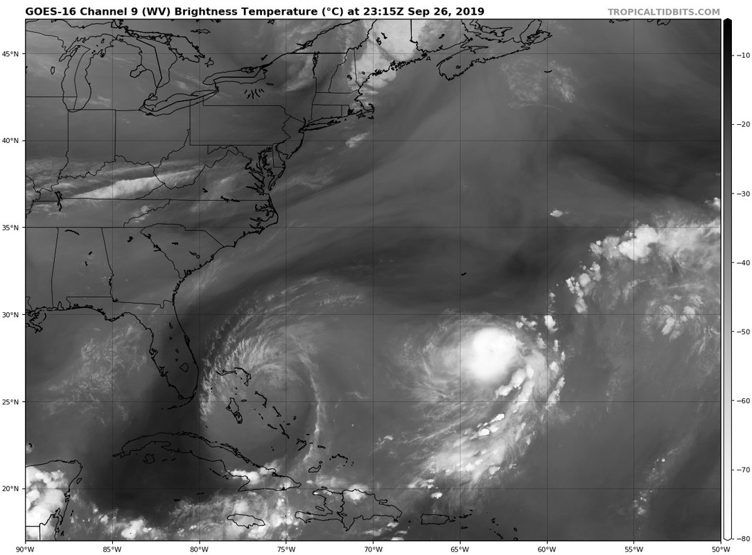
Seems the dry air left behind by Jerry is less than what I expected looking at the WV loop. Looks moist between Karen and the Bahamas:

Image
2 likes   

User avatar
GCANE
S2K Supporter
S2K Supporter
Posts: 10787
Joined: Mon Oct 22, 2007 8:03 am

Re: ATL: KAREN - Tropical Storm - Discussion

#1011 Postby GCANE » Thu Sep 26, 2019 7:45 pm

That IR hole is indicative of the development of a warm core.
And it is pretty much right on the CoC.
Red X marks the CoC.
Black dot to the NW is the Warm Core.


Image
0 likes   

User avatar
GCANE
S2K Supporter
S2K Supporter
Posts: 10787
Joined: Mon Oct 22, 2007 8:03 am

Re: ATL: KAREN - Tropical Storm - Discussion

#1012 Postby GCANE » Thu Sep 26, 2019 7:50 pm

Stacked now surface to 700mb.
Big improvement from this morning.

Image
3 likes   

User avatar
GCANE
S2K Supporter
S2K Supporter
Posts: 10787
Joined: Mon Oct 22, 2007 8:03 am

Re: ATL: KAREN - Tropical Storm - Discussion

#1013 Postby GCANE » Thu Sep 26, 2019 7:54 pm

Up to 40 knts on AMSU est,

Image
0 likes   

AutoPenalti
Category 5
Category 5
Posts: 3949
Age: 27
Joined: Mon Aug 17, 2015 4:16 pm
Location: Ft. Lauderdale, Florida

Re: ATL: KAREN - Tropical Storm - Discussion

#1014 Postby AutoPenalti » Thu Sep 26, 2019 8:54 pm

GCANE wrote:Stacked now surface to 700mb.
Big improvement from this morning.

https://i.imgur.com/uUHQiWg.gif

Still looks elongated.
0 likes   
The posts in this forum are NOT official forecasts and should not be used as such. They are just the opinion of the poster and may or may not be backed by sound meteorological data. They are NOT endorsed by any professional institution or STORM2K. For official information, please refer to products from the NHC and NWS.


Model Runs Cheat Sheet:
GFS (5:30 AM/PM, 11:30 AM/PM)
HWRF, GFDL, UKMET, NAVGEM (6:30-8:00 AM/PM, 12:30-2:00 AM/PM)
ECMWF (1:45 AM/PM)

TCVN
is a weighted averaged

floridasun78
Category 5
Category 5
Posts: 3755
Joined: Sun May 17, 2009 10:16 pm
Location: miami fl

Re: ATL: KAREN - Tropical Storm - Discussion

#1015 Postby floridasun78 » Thu Sep 26, 2019 9:25 pm

nhc dont see this any strong weaking from now on so dont see this getting any stronger going be td by sat
0 likes   

CaribJam
Tropical Depression
Tropical Depression
Posts: 74
Joined: Thu Aug 25, 2005 2:29 pm
Location: Jamaica

Re: ATL: KAREN - Tropical Storm - Discussion

#1016 Postby CaribJam » Thu Sep 26, 2019 9:27 pm

AutoPenalti wrote:
GCANE wrote:Stacked now surface to 700mb.
Big improvement from this morning.

https://i.imgur.com/uUHQiWg.gif

Still looks elongated.


Does anyone have any idea of how Karen should look before/while making the loop or what impact, if any, Lorenzo will have on her?
0 likes   

User avatar
HDGator
S2K Supporter
S2K Supporter
Posts: 233
Joined: Fri Sep 17, 2004 3:03 pm
Location: Lewisville, NC

Re: ATL: KAREN - Tropical Storm - Discussion

#1017 Postby HDGator » Thu Sep 26, 2019 9:43 pm

Karen should have died by now. Why didn't anyone tell her Bones was called out?
Why won't she dissipate like she should?
The models agree?
0 likes   
Personal Forecast Disclaimer:
The posts in this forum are NOT official forecast and should not be used as such. They are just the opinion of the poster and may or may not be backed by sound meteorological data. They are NOT endorsed by any professional institution or storm2k.org. For official information, please refer to the NHC and NWS products.

wx98
Category 5
Category 5
Posts: 1218
Joined: Sat Aug 25, 2018 9:24 pm

Re: ATL: KAREN - Tropical Storm - Discussion

#1018 Postby wx98 » Thu Sep 26, 2019 9:45 pm

The hurricane center isn’t optimistic...

...KAREN FORECAST TO DEGENERATE INTO A REMNANT LOW BY SATURDAY...
11:00 PM AST Thu Sep 26
Location: 27.8°N 62.1°W
Moving: NE at 8 mph
Min pressure: 1005 mb
Max sustained: 40 mph
0 likes   

User avatar
HDGator
S2K Supporter
S2K Supporter
Posts: 233
Joined: Fri Sep 17, 2004 3:03 pm
Location: Lewisville, NC

Re: ATL: KAREN - Tropical Storm - Discussion

#1019 Postby HDGator » Thu Sep 26, 2019 9:56 pm

wx98 wrote:The hurricane center isn’t optimistic...

...KAREN FORECAST TO DEGENERATE INTO A REMNANT LOW BY SATURDAY...
11:00 PM AST Thu Sep 26
Location: 27.8°N 62.1°W
Moving: NE at 8 mph
Min pressure: 1005 mb
Max sustained: 40 mph

Well, we have one day to see how this forecast works out.
I'm not doubting it; but Karen has appeared to exceed expectations.
We'll see what happens tomorrow.
0 likes   
Personal Forecast Disclaimer:
The posts in this forum are NOT official forecast and should not be used as such. They are just the opinion of the poster and may or may not be backed by sound meteorological data. They are NOT endorsed by any professional institution or storm2k.org. For official information, please refer to the NHC and NWS products.

User avatar
HDGator
S2K Supporter
S2K Supporter
Posts: 233
Joined: Fri Sep 17, 2004 3:03 pm
Location: Lewisville, NC

Re: ATL: KAREN - Tropical Storm - Discussion

#1020 Postby HDGator » Thu Sep 26, 2019 10:07 pm

wx98 wrote:The hurricane center isn’t optimistic...

...KAREN FORECAST TO DEGENERATE INTO A REMNANT LOW BY SATURDAY...
11:00 PM AST Thu Sep 26
Location: 27.8°N 62.1°W
Moving: NE at 8 mph
Min pressure: 1005 mb
Max sustained: 40 mph


Karen continues to strengthen on IR but we'll see where she goes from here...
https://rammb-slider.cira.colostate.edu/?sat=goes-16&z=4&im=12&ts=1&st=0&et=0&speed=130&motion=loop&map=1&lat=0&opacity%5B0%5D=1&hidden%5B0%5D=0&pause=0&slider=-1&hide_controls=0&mouse_draw=0&follow_feature=0&follow_hide=0&s=rammb-slider&sec=full_disk&p%5B0%5D=band_13&x=12818&y=5391
0 likes   
Personal Forecast Disclaimer:
The posts in this forum are NOT official forecast and should not be used as such. They are just the opinion of the poster and may or may not be backed by sound meteorological data. They are NOT endorsed by any professional institution or storm2k.org. For official information, please refer to the NHC and NWS products.


Return to “2019”

Who is online

Users browsing this forum: No registered users and 31 guests