BULLETIN
Tropical Storm Melissa Advisory Number 6
NWS National Hurricane Center Miami FL AL142019
500 PM AST Sat Oct 12 2019
...MELISSA MAKES A TRANSITION TO A TROPICAL STORM...
...SHOULD WEAKEN AS IT ACCELERATES AWAY FROM THE UNITED STATES
TONIGHT...
SUMMARY OF 500 PM AST...2100 UTC...INFORMATION
----------------------------------------------
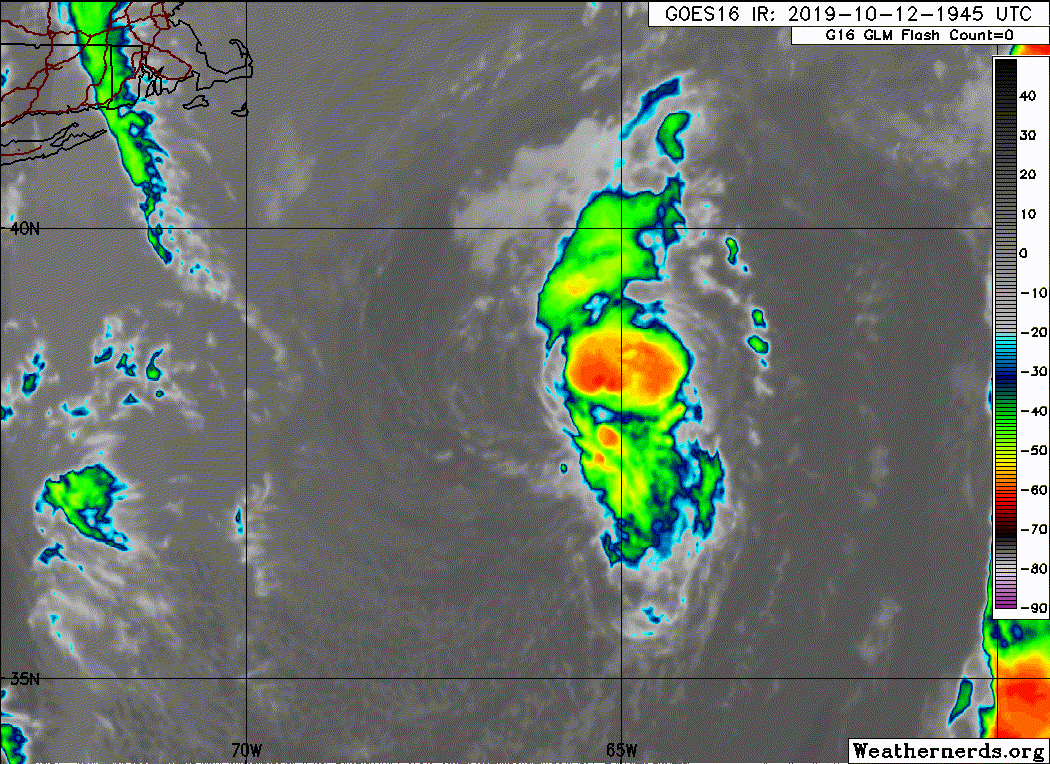
LOCATION...38.4N 65.6W
ABOUT 305 MI...490 KM SE OF NANTUCKET MASSACHUSETTS
MAXIMUM SUSTAINED WINDS...50 MPH...85 KM/H
PRESENT MOVEMENT...ENE OR 70 DEGREES AT 12 MPH...19 KM/H
MINIMUM CENTRAL PRESSURE...999 MB...29.50 INCHES
WATCHES AND WARNINGS
--------------------
There are no coastal tropical cyclone watches or warnings in effect.
For information on coastal flooding hazards, see products issued by
your local National Weather Service office at weather.gov.
DISCUSSION AND OUTLOOK
----------------------
At 500 PM AST (2100 UTC), the center of Tropical Storm Melissa was
located near latitude 38.4 North, longitude 65.6 West. Melissa is
moving toward the east-northeast at near 12 mph (19 km/h), and this
general motion is expected to continue with a gradual increase in
forward speed through Monday. On the forecast track, Melissa will
continue to move away from the U.S. Mid-Atlantic and New England
coasts.
Maximum sustained winds are near 50 mph (85 km/h) with higher gusts.
Gradual weakening is expected over the next day or so, and Melissa
is forecast to become a post-tropical remnant low by Sunday.
Tropical-storm-force winds extend outward up to 60 miles (95 km)
from the center.
The estimated minimum central pressure is 999 mb (29.50 inches).
HAZARDS AFFECTING LAND
----------------------
COASTAL FLOODING: Minor to moderate coastal flooding will occur
along some portions of the U.S. Mid-Atlantic and southeastern coast
through the rest of the weekend around times of high tide.
SURF: Swells generated by Melissa are affecting much of the U.S.
east coast, portions of the Bahamas, Bermuda, and Atlantic Canada.
These swells will result in life-threatening surf and rip current
conditions. Please consult products from your local weather office.
NEXT ADVISORY
-------------
Next complete advisory at 1100 PM AST.
$$
Forecaster Latto
Tropical Storm Melissa Discussion Number 6
NWS National Hurricane Center Miami FL AL142019
500 PM AST Sat Oct 12 2019
Convection has continued to persist near the center of Melissa
throughout the day, and only in the past few hours have the affects
of increasing westerly shear begun to erode the convection from the
western side of the cyclone. A pair of scatterometer passes late
this morning showed that the wind field associated with the storm
had contracted, with the strongest winds occurring within 50 n mi of
the center. They also revealed that the radius of maximum winds had
decreased to 20 n mi. Based on these data along with a tropical
structure apparent in satellite and microwave data, it is likely
that Melissa completed a transition to a tropical cyclone at some
point this morning. A recent Dvorak classification from TAFB, an
objective estimate from UW-CIMSS ADT, and an earlier scatterometer
pass all support an initial intensity of 45 kt for this advisory.
The westerly shear beginning to affect Melissa is expected to
gradually increase over the next few days. Through tonight, the
cyclone will move over waters of 23-24 C. In addition, the upper
trough over the storm that has aided in maintaining its convection
will weaken and lift northeast of the cyclone over the next day or
so. The combination of these factors should cause Melissa to weaken,
and the cyclone is forecast to become a post-tropical remnant low by
Sunday. The global model intensity forecasts appear to be
capturing the strongest winds in a frontal zone well-removed to the
northeast of Melissa and not directly associated with the cyclone
itself. Thus, the NHC forecast is very similar to the previous one,
and continues to be lower than the global model guidance.
Melissa is moving east-northeastward, or 070/10 kt. The increasing
westerly flow will cause the cyclone to gradually accelerate through
Monday. This motion will continue, with a slight turn to the east in
a few days, just before the cyclone is absorbed by a frontal zone.
The new NHC track forecast is close to the previous one and in the
middle of the various consensus aids.
Ongoing hazards from coastal flooding will continue to be covered by
non-tropical products from local National Weather Service forecast
offices.
Key Messages:
1. Although Melissa is forecast to weaken and move away from the
east coast, minor to moderate coastal flooding is still expected
along portions of the U.S. Mid-Atlantic and southeastern coasts
around times of high tide for the remainder of the weekend. For more
information, see products issued by local National Weather Service
forecast offices at weather.gov.
FORECAST POSITIONS AND MAX WINDS
INIT 12/2100Z 38.4N 65.6W 45 KT 50 MPH
12H 13/0600Z 39.0N 63.5W 35 KT 40 MPH
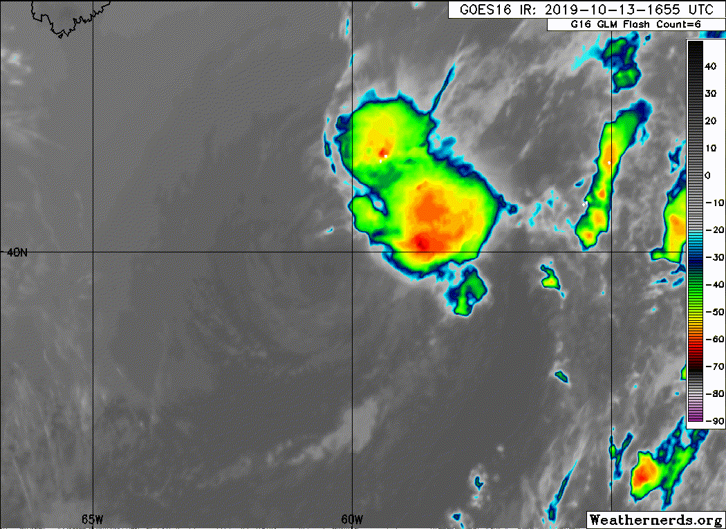
24H 13/1800Z 39.8N 60.0W 30 KT 35 MPH...POST-TROP/REMNT LOW
36H 14/0600Z 40.7N 55.9W 30 KT 35 MPH...POST-TROP/REMNT LOW
48H 14/1800Z 41.6N 51.6W 30 KT 35 MPH...POST-TROP/REMNT LOW
72H 15/1800Z 42.4N 39.9W 25 KT 30 MPH...POST-TROP/REMNT LOW
96H 16/1800Z...ABSORBED BY A FRONTAL ZONE
$$
Forecaster Latto
Tropical Storm Melissa Advisory Number 6
NWS National Hurricane Center Miami FL AL142019
500 PM AST Sat Oct 12 2019
...MELISSA MAKES A TRANSITION TO A TROPICAL STORM...
...SHOULD WEAKEN AS IT ACCELERATES AWAY FROM THE UNITED STATES
TONIGHT...
SUMMARY OF 500 PM AST...2100 UTC...INFORMATION
----------------------------------------------
LOCATION...38.4N 65.6W
ABOUT 305 MI...490 KM SE OF NANTUCKET MASSACHUSETTS
MAXIMUM SUSTAINED WINDS...50 MPH...85 KM/H
PRESENT MOVEMENT...ENE OR 70 DEGREES AT 12 MPH...19 KM/H
MINIMUM CENTRAL PRESSURE...999 MB...29.50 INCHES
WATCHES AND WARNINGS
--------------------
There are no coastal tropical cyclone watches or warnings in effect.
For information on coastal flooding hazards, see products issued by
your local National Weather Service office at weather.gov.
DISCUSSION AND OUTLOOK
----------------------
At 500 PM AST (2100 UTC), the center of Tropical Storm Melissa was
located near latitude 38.4 North, longitude 65.6 West. Melissa is
moving toward the east-northeast at near 12 mph (19 km/h), and this
general motion is expected to continue with a gradual increase in
forward speed through Monday. On the forecast track, Melissa will
continue to move away from the U.S. Mid-Atlantic and New England
coasts.
Maximum sustained winds are near 50 mph (85 km/h) with higher gusts.
Gradual weakening is expected over the next day or so, and Melissa
is forecast to become a post-tropical remnant low by Sunday.
Tropical-storm-force winds extend outward up to 60 miles (95 km)
from the center.
The estimated minimum central pressure is 999 mb (29.50 inches).
HAZARDS AFFECTING LAND
----------------------
COASTAL FLOODING: Minor to moderate coastal flooding will occur
along some portions of the U.S. Mid-Atlantic and southeastern coast
through the rest of the weekend around times of high tide.
SURF: Swells generated by Melissa are affecting much of the U.S.
east coast, portions of the Bahamas, Bermuda, and Atlantic Canada.
These swells will result in life-threatening surf and rip current
conditions. Please consult products from your local weather office.
NEXT ADVISORY
-------------
Next complete advisory at 1100 PM AST.
$$
Forecaster Latto
Tropical Storm Melissa Discussion Number 6
NWS National Hurricane Center Miami FL AL142019
500 PM AST Sat Oct 12 2019
Convection has continued to persist near the center of Melissa
throughout the day, and only in the past few hours have the affects
of increasing westerly shear begun to erode the convection from the
western side of the cyclone. A pair of scatterometer passes late
this morning showed that the wind field associated with the storm
had contracted, with the strongest winds occurring within 50 n mi of
the center. They also revealed that the radius of maximum winds had
decreased to 20 n mi. Based on these data along with a tropical
structure apparent in satellite and microwave data, it is likely
that Melissa completed a transition to a tropical cyclone at some
point this morning. A recent Dvorak classification from TAFB, an
objective estimate from UW-CIMSS ADT, and an earlier scatterometer
pass all support an initial intensity of 45 kt for this advisory.
The westerly shear beginning to affect Melissa is expected to
gradually increase over the next few days. Through tonight, the
cyclone will move over waters of 23-24 C. In addition, the upper
trough over the storm that has aided in maintaining its convection
will weaken and lift northeast of the cyclone over the next day or
so. The combination of these factors should cause Melissa to weaken,
and the cyclone is forecast to become a post-tropical remnant low by
Sunday. The global model intensity forecasts appear to be
capturing the strongest winds in a frontal zone well-removed to the
northeast of Melissa and not directly associated with the cyclone
itself. Thus, the NHC forecast is very similar to the previous one,
and continues to be lower than the global model guidance.
Melissa is moving east-northeastward, or 070/10 kt. The increasing
westerly flow will cause the cyclone to gradually accelerate through
Monday. This motion will continue, with a slight turn to the east in
a few days, just before the cyclone is absorbed by a frontal zone.
The new NHC track forecast is close to the previous one and in the
middle of the various consensus aids.
Ongoing hazards from coastal flooding will continue to be covered by
non-tropical products from local National Weather Service forecast
offices.
Key Messages:
1. Although Melissa is forecast to weaken and move away from the
east coast, minor to moderate coastal flooding is still expected
along portions of the U.S. Mid-Atlantic and southeastern coasts
around times of high tide for the remainder of the weekend. For more
information, see products issued by local National Weather Service
forecast offices at weather.gov.
FORECAST POSITIONS AND MAX WINDS
INIT 12/2100Z 38.4N 65.6W 45 KT 50 MPH
12H 13/0600Z 39.0N 63.5W 35 KT 40 MPH
24H 13/1800Z 39.8N 60.0W 30 KT 35 MPH...POST-TROP/REMNT LOW
36H 14/0600Z 40.7N 55.9W 30 KT 35 MPH...POST-TROP/REMNT LOW
48H 14/1800Z 41.6N 51.6W 30 KT 35 MPH...POST-TROP/REMNT LOW
72H 15/1800Z 42.4N 39.9W 25 KT 30 MPH...POST-TROP/REMNT LOW
96H 16/1800Z...ABSORBED BY A FRONTAL ZONE
$$
Forecaster Latto