ATL: FIFTEEN - Remnants - Discussion

Moderator: S2k Moderators

Message
Author
User avatar
Nancy Smar
Category 5
Category 5
Posts: 1081
Age: 23
Joined: Wed Aug 16, 2017 10:03 pm

ATL: FIFTEEN - Remnants - Discussion

#1 Postby Nancy Smar » Sun Oct 13, 2019 6:19 am

AL, 94, 2019101312, , BEST, 0, 119N, 156W, 20, 1008, LO,

Thread at Talkling Tropics forum that was the topic for this area.
http://www.storm2k.org/phpbb2/viewtopic.php?f=31&t=120655
1 likes   

User avatar
Abdullah
Category 1
Category 1
Posts: 285
Joined: Sat Sep 08, 2018 4:28 pm
Location: Miramar, FL

Re: ATL: INVEST 94L - Discussion

#2 Postby Abdullah » Sun Oct 13, 2019 6:36 am

When do we get a separate model thread? When it becomes a named storm? a depression?
1 likes   

User avatar
cycloneye
Admin
Admin
Posts: 139065
Age: 67
Joined: Thu Oct 10, 2002 10:54 am
Location: San Juan, Puerto Rico

Re: ATL: INVEST 94L - Discussion

#3 Postby cycloneye » Sun Oct 13, 2019 6:39 am

Abdullah wrote:When do we get a separate model thread? When it becomes a named storm? a depression?


Is now up.

viewtopic.php?f=59&t=120665&p=2787209#p2787209
1 likes   
Visit the Caribbean-Central America Weather Thread where you can find at first post web cams,radars
and observations from Caribbean basin members Click Here

User avatar
cycloneye
Admin
Admin
Posts: 139065
Age: 67
Joined: Thu Oct 10, 2002 10:54 am
Location: San Juan, Puerto Rico

Re: ATL: INVEST 94L - Discussion

#4 Postby cycloneye » Sun Oct 13, 2019 6:53 am

A tropical wave, accompanied by a broad area of low pressure, is
producing a concentrated area of showers and thunderstorms over
portions of western Africa. The wave is expected to move
west-northwestward over the next day or so and emerge off the
coast of Africa later this afternoon. Environmental conditions are
expected to be conducive for some additional development to occur
during the next few days while the system moves west-northwestward
to northwestward toward the Cabo Verde Islands on Tuesday and
Wednesday. Strong upper-level winds should prevent additional
development by midweek. Interests in and around the Cabo Verde
Islands should monitor the progress of this disturbance.
* Formation chance through 48 hours...low...30 percent.
* Formation chance through 5 days...medium...50 percent.
1 likes   
Visit the Caribbean-Central America Weather Thread where you can find at first post web cams,radars
and observations from Caribbean basin members Click Here

User avatar
cycloneye
Admin
Admin
Posts: 139065
Age: 67
Joined: Thu Oct 10, 2002 10:54 am
Location: San Juan, Puerto Rico

Re: ATL: INVEST 94L - Discussion

#5 Postby cycloneye » Sun Oct 13, 2019 8:05 am

Is a big blob.

Image
3 likes   
Visit the Caribbean-Central America Weather Thread where you can find at first post web cams,radars
and observations from Caribbean basin members Click Here

User avatar
cycloneye
Admin
Admin
Posts: 139065
Age: 67
Joined: Thu Oct 10, 2002 10:54 am
Location: San Juan, Puerto Rico

Re: ATL: INVEST 94L - Discussion

#6 Postby cycloneye » Sun Oct 13, 2019 1:02 pm

A vigorous tropical wave, accompanied by a well-defined low pressure
system, has emerged over the far eastern tropical Atlantic Ocean
just west of the coast of Guinea-Bissau. Showers and thunderstorms
are beginning to show signs of organization, and environmental
conditions are expected to be conducive for the development of a
tropical depression during the next few days while the disturbance
moves west-northwestward to northwestward over or just east of the
Cabo Verde Islands. Strong upper-level winds should prevent any
significant development by midweek. Interests in and around the
Cabo Verde Islands should monitor the progress of this system.
* Formation chance through 48 hours...medium...50 percent.
* Formation chance through 5 days...high...70 percent.
0 likes   
Visit the Caribbean-Central America Weather Thread where you can find at first post web cams,radars
and observations from Caribbean basin members Click Here

User avatar
1900hurricane
Category 5
Category 5
Posts: 6044
Age: 32
Joined: Fri Feb 06, 2015 12:04 pm
Location: Houston, TX
Contact:

Re: ATL: INVEST 94L - Discussion

#7 Postby 1900hurricane » Sun Oct 13, 2019 1:04 pm

ASCAT data indicates that it probably exited the coast just before 12Z.

Image

Image
1 likes   
Contract Meteorologist. TAMU & MSST. Fiercely authentic, one of a kind. We are all given free will, so choose a life meant to be lived. We are the Masters of our own Stories.
Opinions expressed are mine alone.

Follow me on Twitter at @1900hurricane : Read blogs at https://1900hurricane.wordpress.com/

User avatar
CyclonicFury
Category 5
Category 5
Posts: 1975
Age: 25
Joined: Sun Jul 02, 2017 12:32 pm
Location: NC
Contact:

Re: ATL: INVEST 94L - Discussion

#8 Postby CyclonicFury » Sun Oct 13, 2019 1:14 pm

Is it really mid-October? This is much more typical of early-mid September.
3 likes   
NCSU B.S. in Meteorology Class of 2021. Tropical weather blogger at http://www.cyclonicfury.com. My forecasts and thoughts are NOT official, for official forecasts please consult the National Hurricane Center.

CrazyC83
Professional-Met
Professional-Met
Posts: 33393
Joined: Tue Mar 07, 2006 11:57 pm
Location: Deep South, for the first time!

Re: ATL: INVEST 94L - Discussion

#9 Postby CrazyC83 » Sun Oct 13, 2019 2:58 pm

This would be the farthest east a storm had developed in the deep tropics in October? It's definitely not something you normally see in the late season. It looks to already be a TD looking at the satellite and wind data though?
0 likes   

User avatar
1900hurricane
Category 5
Category 5
Posts: 6044
Age: 32
Joined: Fri Feb 06, 2015 12:04 pm
Location: Houston, TX
Contact:

Re: ATL: INVEST 94L - Discussion

#10 Postby 1900hurricane » Sun Oct 13, 2019 6:39 pm

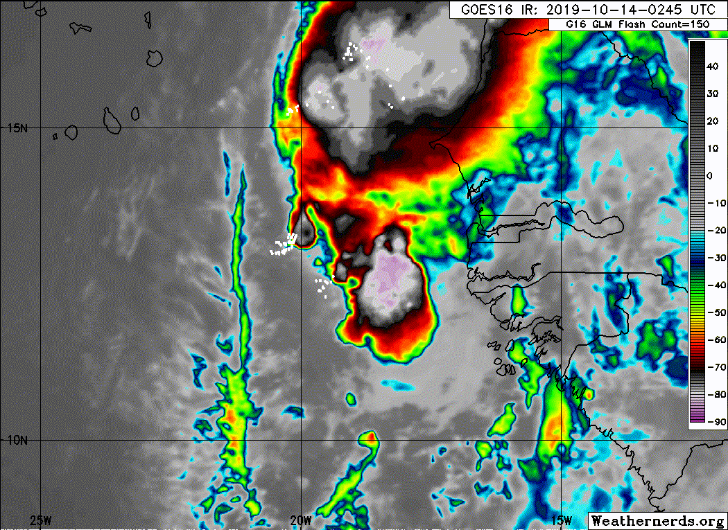
CrazyC83 wrote:This would be the farthest east a storm had developed in the deep tropics in October? It's definitely not something you normally see in the late season. It looks to already be a TD looking at the satellite and wind data though?

I ran a search and came up with only two other systems: Ginger '67 and 17L from 1972.

Image
0 likes   
Contract Meteorologist. TAMU & MSST. Fiercely authentic, one of a kind. We are all given free will, so choose a life meant to be lived. We are the Masters of our own Stories.
Opinions expressed are mine alone.

Follow me on Twitter at @1900hurricane : Read blogs at https://1900hurricane.wordpress.com/

User avatar
cycloneye
Admin
Admin
Posts: 139065
Age: 67
Joined: Thu Oct 10, 2002 10:54 am
Location: San Juan, Puerto Rico

Re: ATL: INVEST 94L - Discussion

#11 Postby cycloneye » Sun Oct 13, 2019 6:50 pm

A strong tropical wave, accompanied by a broad area of low pressure,
is located over the far eastern tropical Atlantic Ocean just west of
the west coast of Africa. Although showers and thunderstorms
associated with the system decreased somewhat earlier this evening,
satellite imagery indicates that they are beginning to increase once
again. Environmental conditions are expected to be conducive for
development, and a tropical depression is likely to form during the
next couple of days while the disturbance moves west-northwestward
to northwestward over or just east of the Cabo Verde Islands.
Strong upper-level winds should prevent any further development by
midweek. Regardless of development, this system is likely to bring
locally heavy rainfall and gusty winds to portions of the Cabo Verde
Islands on Monday and Tuesday. Interests in and around the Cabo
Verde Islands should monitor the progress of this system.
* Formation chance through 48 hours...medium...60 percent.
* Formation chance through 5 days...high...70 percent.
0 likes   
Visit the Caribbean-Central America Weather Thread where you can find at first post web cams,radars
and observations from Caribbean basin members Click Here

Sciencerocks
Category 5
Category 5
Posts: 7286
Age: 38
Joined: Thu Jul 06, 2017 1:51 am

Re: ATL: INVEST 94L - Discussion

#12 Postby Sciencerocks » Mon Oct 14, 2019 2:13 am

Image
0 likes   

Sciencerocks
Category 5
Category 5
Posts: 7286
Age: 38
Joined: Thu Jul 06, 2017 1:51 am

Re: ATL: INVEST 94L - Discussion

#13 Postby Sciencerocks » Mon Oct 14, 2019 2:14 am

Tropical Weather Outlook
NWS National Hurricane Center Miami FL
200 AM EDT Mon Oct 14 2019

For the North Atlantic...Caribbean Sea and the Gulf of Mexico:

The National Hurricane Center is issuing advisories on Tropical
Storm Melissa, located several hundred miles south of Newfoundland,
Canada.

A broad area of low pressure is located over the far eastern
tropical Atlantic Ocean just west of the west coast of Africa with
disorganized shower and thunderstorm activity. Environmental
conditions are expected to be conducive for development, and a
tropical depression is likely to form during the next day or so
while the disturbance moves west-northwestward to northwestward near
or northeast of the Cabo Verde Islands. Strong upper-level winds
should prevent any further development by midweek. This system is
forecast to bring locally heavy rainfall and gusty winds to portions
of the Cabo Verde Islands later today through Tuesday, and interests
there should monitor the progress of this system.
* Formation chance through 48 hours...high...70 percent.
* Formation chance through 5 days...high...70 percent.
0 likes   

Sciencerocks
Category 5
Category 5
Posts: 7286
Age: 38
Joined: Thu Jul 06, 2017 1:51 am

Re: ATL: INVEST 94L - Discussion

#14 Postby Sciencerocks » Mon Oct 14, 2019 6:01 am

Image
0 likes   

TallyTracker
Category 2
Category 2
Posts: 584
Joined: Thu Oct 11, 2018 2:46 pm

Re: ATL: INVEST 94L - Discussion

#15 Postby TallyTracker » Mon Oct 14, 2019 9:14 am

The structure of 94L looks good, but it’s gonna need more convective organization to be upgraded.
0 likes   
Fran '96, Georges '98, Gordon '00, Gabrielle '01, Charley '04, Frances '04, Jeanne '04, Barry '07, Fay '08, Debby '12, Matthew '16, Emily '17, Irma '17, Michael ‘18, Elsa ‘21, Fred ‘21, Mindy ‘21, Nicole ‘22, Idalia ‘23

User avatar
galaxy401
Category 5
Category 5
Posts: 2299
Age: 28
Joined: Sat Aug 25, 2012 9:04 pm
Location: Casa Grande, Arizona

Re: ATL: INVEST 94L - Discussion

#16 Postby galaxy401 » Mon Oct 14, 2019 1:08 pm

Almost a TD.

Tropical Weather Outlook
NWS National Hurricane Center Miami FL
200 PM EDT Mon Oct 14 2019

For the North Atlantic...Caribbean Sea and the Gulf of Mexico:

The National Hurricane Center has issued the last advisory on
Post-Tropical Cyclone Storm Melissa, located several hundred miles
south-southeast of Newfoundland, Canada.

A large low pressure system located over the far eastern tropical
Atlantic Ocean less than 300 miles southeast of the Cabo Verde
Islands is moving slowly west-northwestward to northwestward.
Satellite imagery and surface wind data indicate that low has become
better defined since yesterday, and shower and thunderstorm activity
is showing increasing signs of organization. If this recent
development trend continues, then a tropical depression or a
tropical storm storm is likely to form later tonight or early
Tuesday while the low moves generally northwestward toward the Cabo
Verde Islands. Strong upper-level winds should prevent any further
development by midweek. This system is forecast to bring locally
heavy rainfall and gusty winds to portions of the Cabo Verde Islands
tonight through Wednesday morning, and interests there should
monitor the progress of this system.
* Formation chance through 48 hours...high...90 percent.
* Formation chance through 5 days...high...90 percent.
0 likes   
Got my eyes on moving right into Hurricane Alley: Florida.

User avatar
CyclonicFury
Category 5
Category 5
Posts: 1975
Age: 25
Joined: Sun Jul 02, 2017 12:32 pm
Location: NC
Contact:

Re: ATL: INVEST 94L - Discussion

#17 Postby CyclonicFury » Mon Oct 14, 2019 1:38 pm

I'm surprised the eastern Cabo Verde Islands haven't issued tropical storm watches/warnings yet. This is an unprecedented event for those islands for this late in the season.
3 likes   
NCSU B.S. in Meteorology Class of 2021. Tropical weather blogger at http://www.cyclonicfury.com. My forecasts and thoughts are NOT official, for official forecasts please consult the National Hurricane Center.

User avatar
northjaxpro
S2K Supporter
S2K Supporter
Posts: 8900
Joined: Mon Sep 27, 2010 11:21 am
Location: Jacksonville, FL

Re: ATL: INVEST 94L - Discussion

#18 Postby northjaxpro » Mon Oct 14, 2019 1:41 pm

This will be Nestor before I go to bed later tonight literally, if it isn't already. I truly feel it is a TS now!

It is perplexing to phathom we are seeing this type of CV storm in mid-October. Just incredble we are seeing this. What a season 2019 has been uh?
0 likes   
NEVER, EVER SAY NEVER in the tropics and weather in general, and most importantly, with life itself!!

________________________________________________________________________________________

Fay 2008 Beryl 2012 Debby 2012 Colin 2016 Hermine 2016 Julia 2016 Matthew 2016 Irma 2017 Dorian 2019

Sciencerocks
Category 5
Category 5
Posts: 7286
Age: 38
Joined: Thu Jul 06, 2017 1:51 am

Re: ATL: INVEST 94L - Discussion

#19 Postby Sciencerocks » Mon Oct 14, 2019 2:08 pm

Image
3 likes   

MarioProtVI
Category 2
Category 2
Posts: 670
Age: 22
Joined: Sun Sep 29, 2019 7:33 pm
Location: New Jersey

Re: ATL: INVEST 94L - Discussion

#20 Postby MarioProtVI » Mon Oct 14, 2019 2:11 pm

AL, 15, 2019101418, , BEST, 0, 130N, 199W, 30, 1006, TD, 34, NEQ, 0, 0, 0, 0, 1011, 150, 50, 0, 0, L, 0, , 0, 0, FIFTEEN, D, 0, , 0, 0,

TD 15 is here.
3 likes   


Return to “2019”

Who is online

Users browsing this forum: No registered users and 74 guests