98E INVEST 191014 1200 14.0N 97.0W EPAC 15 NA
EPAC: SEVENTEEN-E - Remnants
Moderator: S2k Moderators
-
Nancy Smar

- Category 5

- Posts: 1081
- Age: 23
- Joined: Wed Aug 16, 2017 10:03 pm
-
Nancy Smar
- Category 5
- Posts: 1081
- Age: 23
- Joined: Wed Aug 16, 2017 10:03 pm
Re: EPAC: INVEST 98E
EP, 98, 2019101412, , BEST, 0, 109N, 883W, 25, 1008, DB, 34, NEQ, 0, 0, 0, 0, 1010, 300, 90, 0, 0, E, 0, , 0, 0, INVEST, S, 0, , 0, 0, 0, 0, genesis-num, 039, SPAWNINVEST, ep742019 to ep982019,
0 likes
-
cycloneye

- Admin

- Posts: 139051
- Age: 67
- Joined: Thu Oct 10, 2002 10:54 am
- Location: San Juan, Puerto Rico
Re: EPAC: INVEST 98E
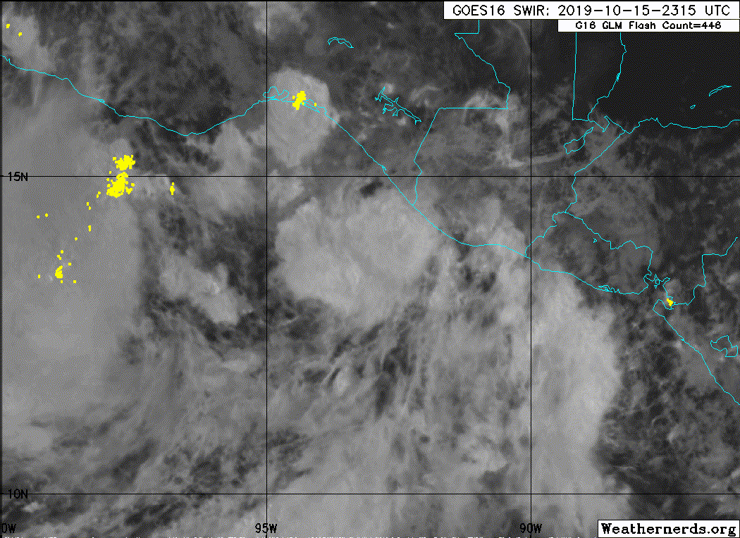
Showers and thunderstorms have become more concentrated during the
past several hours near an elongated area of low pressure located
about 100 miles south-southwest of the coast of Guatemala.
Environmental conditions are conducive for development of this
system, and a tropical depression or tropical storm is expected to
form tonight or on Wednesday while the system moves
west-northwestward at about 10 mph, toward the coast of southeastern
Mexico. Regardless of development, heavy rainfall currently
occurring across Costa Rica, Nicaragua, Honduras and El Salvador is
forecast to spread westward over Guatemala tonight, and across
southern Mexico on Wednesday. These rains could cause flooding and
mudslides, especially in mountainous areas. Interests in
southeastern Mexico should monitor the progress of this system.
* Formation chance through 48 hours...high...90 percent.
* Formation chance through 5 days...high...90 percent.
0 likes
Visit the Caribbean-Central America Weather Thread where you can find at first post web cams,radars
and observations from Caribbean basin members Click Here
and observations from Caribbean basin members Click Here
-
Nancy Smar
- Category 5
- Posts: 1081
- Age: 23
- Joined: Wed Aug 16, 2017 10:03 pm
-
Astromanía
- Category 2

- Posts: 737
- Age: 25
- Joined: Sat Aug 25, 2018 10:34 pm
- Location: Monterrey, N.L, México
Re: EPAC: INVEST 98E
The track of this future storm could be a disaster for those who lives in Chiapas, Oaxaca, Guerrero and Michoacan states on Mexico. This could be the deadliest storm this season on EPAC by far but I hope is not!
0 likes
-
Sciencerocks
- Category 5
- Posts: 7283
- Age: 38
- Joined: Thu Jul 06, 2017 1:51 am
-
cycloneye
- Admin
- Posts: 139051
- Age: 67
- Joined: Thu Oct 10, 2002 10:54 am
- Location: San Juan, Puerto Rico
Re: EPAC: INVEST 98E
BULLETIN
Potential Tropical Cyclone Seventeen-E Advisory Number 1
NWS National Hurricane Center Miami FL EP172019
1000 PM CDT Tue Oct 15 2019
...DISTURBANCE FORECAST TO BECOME A TROPICAL STORM ON WEDNESDAY...
...SYSTEM EXPECTED TO BRING HEAVY RAINFALL AND FLASH FLOODING TO
PORTIONS OF SOUTHEASTERN MEXICO...
SUMMARY OF 1000 PM CDT...0300 UTC...INFORMATION
-----------------------------------------------
LOCATION...13.7N 93.4W
ABOUT 210 MI...340 KM SE OF SALINA CRUZ MEXICO
MAXIMUM SUSTAINED WINDS...35 MPH...55 KM/H
PRESENT MOVEMENT...WNW OR 300 DEGREES AT 10 MPH...17 KM/H
MINIMUM CENTRAL PRESSURE...1005 MB...29.68 INCHES
WATCHES AND WARNINGS
--------------------
CHANGES WITH THIS ADVISORY:
The government of Mexico has issued a Tropical Storm Watch from
Barra de Tonala westward to Puerto Escondido.
SUMMARY OF WATCHES AND WARNINGS IN EFFECT:
A Tropical Storm Watch is in effect for...
* Barra de Tonala to Puerto Escondido
A Tropical Storm Watch means that tropical storm conditions are
possible within the watch area, in this case within the next 12
to 24 hours.
For storm information specific to your area, please monitor
products issued by your national meteorological service.
DISCUSSION AND OUTLOOK
----------------------
At 1000 PM CDT (0300 UTC), the disturbance was centered near
latitude 13.7 North, longitude 93.4 West. The system is moving
toward the west-northwest near 10 mph (17 km/h). A west-
northwestward to northwestward motion is expected over the next
day or so. On this track, the disturbance is expected to move
inland over southeastern Mexico on Wednesday within the watch area.
Maximum sustained winds are near 35 mph (55 km/h) with higher gusts.
Some strengthening is expected and the disturbance is forecast to
become a tropical storm later tonight or early Wednesday.
* Formation chance through 48 hours...high...90 percent
* Formation chance through 5 days...high...90 percent
The estimated minimum central pressure is 1005 mb (29.68 inches).
HAZARDS AFFECTING LAND
----------------------
RAINFALL: The disturbance is expected to produce total rainfall
accumulations of 6 to 12 inches with maximum totals of 20 inches
along the southwest coast of Mexico from Chiapas to Guerrero.
Rainfall totals of 3 to 5 inches are expected across El Salvador and
southern Guatemala. This rainfall could produce life-threatening
flash floods and mudslides.
WIND: Tropical storm conditions are possible within the watch area
on Wednesday.
NEXT ADVISORY
-------------
Next intermediate advisory at 100 AM CDT.
Next complete advisory at 400 AM CDT.
$$
Forecaster Brown
Potential Tropical Cyclone Seventeen-E Discussion Number 1
NWS National Hurricane Center Miami FL EP172019
1000 PM CDT Tue Oct 15 2019
Although deep convection associated with the area of low pressure
near the southeastern coast of Mexico has increased since this
afternoon, the overall organization of the system has not increased
enough for it to be considered a tropical cyclone. The system,
however, is predicted to become a tropical storm before it reaches
the southeastern coast of Mexico on Wednesday, and NHC has initiated
advisories on this system as a potential tropical cyclone. The
government of Mexico has elected to issued a tropical storm watch
for a portion of the coast of southeastern Mexico. The initial
intensity of the system is estimated to be 30 kt based on earlier
scatterometer data. The disturbance is located over very warm
waters and within an area of light to moderate northeasterly shear,
which should allow for some strengthening before the system moves
inland. The NHC intensity forecast calls for the disturbance to
become a tropical storm in 12 hours, and it is in good agreement
with the statistical guidance and the global models which show some
slight deepening. The system should quickly weaken and dissipate
over the mountainous terrain of southern Mexico after landfall.
The initial motion estimate is a somewhat uncertain 300/9 kt. A
mid-level ridge over the southeastern Gulf of Mexico is expected to
steer the disturbance west-northwestward during the next day or so,
and this motion should bring the center on the coast within 24
hours. The track guidance is in good agreement and the official
forecast is near the center of the guidance envelope.
The primary threat with this system will be heavy rainfall and the
potential for flash flooding and mudslides in southern Mexico during
the next day or two.
FORECAST POSITIONS AND MAX WINDS
INIT 16/0300Z 13.7N 93.4W 30 KT 35 MPH...POTENTIAL TROP CYCLONE
12H 16/1200Z 14.6N 94.8W 35 KT 40 MPH...TROPICAL STORM
24H 17/0000Z 16.2N 96.2W 35 KT 40 MPH...INLAND
36H 17/1200Z 17.6N 97.1W 25 KT 30 MPH...POST-TROP/REMNT LOW
48H 18/0000Z...DISSIPATED
$$
Forecaster Brown
0 likes
Visit the Caribbean-Central America Weather Thread where you can find at first post web cams,radars
and observations from Caribbean basin members Click Here
and observations from Caribbean basin members Click Here
-
Astromanía
- Category 2
- Posts: 737
- Age: 25
- Joined: Sat Aug 25, 2018 10:34 pm
- Location: Monterrey, N.L, México
Re: EPAC: SEVENTEEN-E - Potential Tropical Cyclone
Second potential tropical cyclone of the year on EPAC this is very unusually
0 likes
-
cycloneye
- Admin
- Posts: 139051
- Age: 67
- Joined: Thu Oct 10, 2002 10:54 am
- Location: San Juan, Puerto Rico
Re: EPAC: SEVENTEEN-E - Potential Tropical Cyclone
BULLETIN
Potential Tropical Cyclone Seventeen-E Advisory Number 3
NWS National Hurricane Center Miami FL EP172019
1000 AM CDT Wed Oct 16 2019
...CENTER OF THE DISTURBANCE MOVING INLAND OVER THE MEXICAN STATE
OF OAXACA...
...MORE RAIN TO COME FOR PORTIONS OF SOUTHEASTERN MEXICO...
SUMMARY OF 1000 AM CDT...1500 UTC...INFORMATION
-----------------------------------------------
LOCATION...16.2N 96.2W
ABOUT 65 MI...105 KM W OF SALINA CRUZ MEXICO
ABOUT 40 MI...65 KM NNE OF PUERTO ANGEL MEXICO
MAXIMUM SUSTAINED WINDS...35 MPH...55 KM/H
PRESENT MOVEMENT...NW OR 315 DEGREES AT 14 MPH...22 KM/H
MINIMUM CENTRAL PRESSURE...1005 MB...29.68 INCHES
WATCHES AND WARNINGS
--------------------
CHANGES WITH THIS ADVISORY:
None.
SUMMARY OF WATCHES AND WARNINGS IN EFFECT:
A Tropical Storm Watch is in effect for...
* Barra de Tonala to Puerto Escondido
A Tropical Storm Watch means that tropical storm conditions are
possible within the watch area, in this case within the next 12
hours.
For storm information specific to your area, please monitor
products issued by your national meteorological service.
DISCUSSION AND OUTLOOK
----------------------
At 1000 AM CDT (1500 UTC), the disturbance was centered near
latitude 16.2 North, longitude 96.2 West. The system is moving
toward the northwest near 14 mph (22 km/h), and this motion is
expected to continue through tonight. On this track, the
disturbance is expected to move farther inland over southeastern
Mexico during the next several hours.
Maximum sustained winds are near 35 mph (55 km/h) with higher
gusts. The disturbance has some chance of becoming a tropical storm
if the center can re-form along the coast later today.
* Formation chance through 48 hours...medium...60 percent
* Formation chance through 5 days...medium...60 percent
The estimated minimum central pressure is 1005 mb (29.68 inches).
HAZARDS AFFECTING LAND
----------------------
RAINFALL: The disturbance is expected to produce total rainfall
accumulations of 5 to 10 inches along the southwest coast of Mexico
from Chiapas to Jalisco, and 2 to 4 inches over southern Guatemala.
Isolated maximum amounts of 15 inches are possible in Mexico.
Rainfall in both Guatemala and Mexico could produce life-threatening
flash floods and mudslides.
WIND: Tropical storm conditions are possible within the watch area
today.
NEXT ADVISORY
-------------
Next intermediate advisory at 100 PM CDT.
Next complete advisory at 400 PM CDT.
$$
Forecaster Beven
Potential Tropical Cyclone Seventeen-E Discussion Number 3
NWS National Hurricane Center Miami FL EP172019
1000 AM CDT Wed Oct 16 2019
Satellite imagery this morning shows that the disturbance continues
to lack a well-defined center, and there is evidence of multiple
low-level cloud swirls near the mean center. One swirl came
onshore a few hours ago just southwest of Salina Cruz, Mexico,
accompanied by wind gusts to tropical-storm force. Another swirl is
currently near or just offshore of Puerto Angel close to a strong
cluster of convection. The mean position between these swirls used
in this advisory is inland over the Mexican state of Oaxaca. The
initial intensity remains 30 kt based partly on surface observations
and partly from continuity with the previous advisory.
The chances that the system will become a tropical cyclone are
diminishing. However, advisories will continue and the tropical
storm watch will remain in effect until it becomes clear that the
center will not try to re-form offshore. If this does not happen,
the disturbance should dissipate over the mountains of central
Mexico between 12-24 h.
The initial motion is a somewhat uncertain 315/12. A general
northwestward motion should continue until the system dissipates.
The primary threat from this disturbance remains heavy rainfall and
the potential for flash flooding and mudslides in southern Mexico
during the next day or two.
FORECAST POSITIONS AND MAX WINDS
INIT 16/1500Z 16.2N 96.2W 30 KT 35 MPH...POTENTIAL TROP CYCLONE
12H 17/0000Z 17.3N 97.6W 20 KT 25 MPH...INLAND
24H 17/1200Z...DISSIPATED
$$
Forecaster Beven
0 likes
Visit the Caribbean-Central America Weather Thread where you can find at first post web cams,radars
and observations from Caribbean basin members Click Here
and observations from Caribbean basin members Click Here
-
Astromanía
- Category 2
- Posts: 737
- Age: 25
- Joined: Sat Aug 25, 2018 10:34 pm
- Location: Monterrey, N.L, México
Re: EPAC: SEVENTEEN-E - Potential Tropical Cyclone
I don't know why shytems this time of the year are killing themselves going inland to quik, I know those recurves at this time but they are literally going in land or just off-shore
0 likes
-
cycloneye
- Admin
- Posts: 139051
- Age: 67
- Joined: Thu Oct 10, 2002 10:54 am
- Location: San Juan, Puerto Rico
Re: EPAC: SEVENTEEN-E - Potential Tropical Cyclone
BULLETIN
Potential Tropical Cyclone Seventeen-E Special Advisory Number 4
NWS National Hurricane Center Miami FL EP172019
100 PM CDT Wed Oct 16 2019
...DISTURBANCE NOW UNLIKELY TO BRING TROPICAL-STORM CONDITIONS TO
THE COAST OF MEXICO...
...RAINFALL THREAT CONTINUES FOR PORTIONS OF SOUTHEASTERN MEXICO...
SUMMARY OF 100 PM CDT...1800 UTC...INFORMATION
----------------------------------------------
LOCATION...16.6N 96.6W
ABOUT 95 MI...155 KM WNW OF SALINA CRUZ MEXICO
ABOUT 65 MI...100 KM N OF PUERTO ANGEL MEXICO
MAXIMUM SUSTAINED WINDS...30 MPH...45 KM/H
PRESENT MOVEMENT...NW OR 310 DEGREES AT 14 MPH...22 KM/H
MINIMUM CENTRAL PRESSURE...1007 MB...29.74 INCHES
WATCHES AND WARNINGS
--------------------
CHANGES WITH THIS ADVISORY:
The Government of Mexico has discontinued the Tropical Storm Watch
for the coast of southeastern Mexico.
SUMMARY OF WATCHES AND WARNINGS IN EFFECT:
There are no coastal watches of warnings in effect.
DISCUSSION AND OUTLOOK
----------------------
At 100 PM CDT (1800 UTC), the disturbance was centered near latitude
16.6 North, longitude 96.6 West. The system is moving toward the
northwest near 14 mph (22 km/h), and this motion is expected to
continue through tonight. On this track, the disturbance is
expected to move farther inland over southeastern Mexico during the
next several hours.
Maximum sustained winds are near 30 mph (45 km/h) with higher gusts.
While the chances that the disturbance will become a tropical
cyclone are decreasing, there is still a small chance that a
tropical depression could develop if the center can re-form along
the coast later today or tonight.
* Formation chance through 48 hours...low...20 percent
* Formation chance through 5 days...low...20 percent
The estimated minimum central pressure is 1007 mb (29.74 inches).
HAZARDS AFFECTING LAND
----------------------
RAINFALL: The disturbance is expected to produce total rainfall
accumulations of 5 to 10 inches along the southwest coast of Mexico
from Chiapas to Jalisco, and 2 to 4 inches over southern Guatemala.
Isolated maximum amounts of 15 inches are possible in Mexico.
Rainfall in both Guatemala and Mexico could produce life-threatening
flash floods and mudslides.
WIND: A few wind gusts to tropical-storm force may occur along
portions of the coast of southeastern Mexico today.
NEXT ADVISORY
-------------
This is the last public advisory issued by the National Hurricane
Center on this system. Please refer to forecasts and warnings from
the Meteorological Service of Mexico for more information on the
ongoing rainfall threat.
$$
Forecaster Beven
0 likes
Visit the Caribbean-Central America Weather Thread where you can find at first post web cams,radars
and observations from Caribbean basin members Click Here
and observations from Caribbean basin members Click Here
Who is online
Users browsing this forum: No registered users and 26 guests