ATL: IOTA - Models

Moderator: S2k Moderators

Message
Author
User avatar
SFLcane
S2K Supporter
S2K Supporter
Posts: 9618
Age: 46
Joined: Sat Jun 05, 2010 1:44 pm
Location: Lake Worth Florida

Re: ATL: INVEST 98L - Models

#121 Postby SFLcane » Thu Nov 12, 2020 1:48 pm

Image

Image
0 likes   

Loveweather12
Tropical Storm
Tropical Storm
Posts: 136
Joined: Thu Aug 20, 2020 2:37 pm

Re: ATL: INVEST 98L - Models

#122 Postby Loveweather12 » Thu Nov 12, 2020 1:53 pm


Starting to turn North it seems. Could just be my eyes though
0 likes   

User avatar
SouthFLTropics
Category 5
Category 5
Posts: 4156
Age: 48
Joined: Thu Aug 14, 2003 8:04 am
Location: Port St. Lucie, Florida

Re: ATL: INVEST 98L - Models

#123 Postby SouthFLTropics » Thu Nov 12, 2020 1:54 pm

Looks like the HWRF slows it to a crawl at 85 west. May get hung up and stuck there until the next trough comes into the picture.
0 likes   
Fourth Generation Floridian...With lots of storm knowledge passed down from my elders...

Personal Storm History: David 79, Andrew 92, Erin 95, Floyd 99, Irene 99, Frances 04, Jeanne 04, Wilma 05, Matthew 16, Irma 17

jlauderdal
S2K Supporter
S2K Supporter
Posts: 6777
Joined: Wed May 19, 2004 5:46 am
Location: NE Fort Lauderdale
Contact:

Re: ATL: INVEST 98L - Models

#124 Postby jlauderdal » Thu Nov 12, 2020 1:55 pm

SFLcane wrote:Well that’s interesting 12z HWRF is moving NW at the end of its run. :eek:

https://i.imgur.com/JJNyhqe.gif

its going to the pacific, its burying itself in CA :roll:

meanwhile, kappa arrives on the scene to the east

we have .7 in the bucket today and guess what, the street has standing water because even with as little as .7 the ground is saturated and no place to go
0 likes   

User avatar
Jr0d
S2K Supporter
S2K Supporter
Posts: 1176
Joined: Tue Aug 27, 2019 10:52 am
Location: Cayo Hueso

Re: ATL: INVEST 98L - Models

#125 Postby Jr0d » Thu Nov 12, 2020 2:03 pm

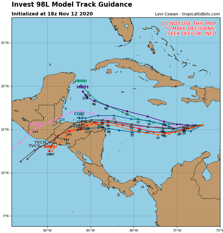
TheProfessor wrote:Very tricky forecast here in terms of track and it will be dependent multiple things. The first thing that will be important is the strength of the system. If the HMON and HWRF are right the system will feel more of the upper level flow. Unfortunately the forecast for the upper level flow itself is quite complicated. Teleconnections are showing the NAO begin to trend negative and the PNA to trend positives. This favors an east coast trough, especially the closer to winter we get. Here's where things get tricky, where that trough sets up will be critical in deciding where this storm goes, assuming we have a deep storm that is. If the GFS is right and the trough is further off the east coast, then the storm will be under the influences of the western ridge and a deeper storm will dive even farther southwestward. However, if the Canadian is right and the trough is closer to the east coast or even centered over it, then the storm will either be caught in no man's land or will be under the influence of the eastern ridge, which would put Cuba and Florida under threat. However, since the Canadian has a weak storm we don't get to see this played out on the 12z Run. I think the HWRF and HMON are showing something in the middle right now and it's likely that the CMC is as well in terms of the 500 pattern. One would expect the Euro to be even more west with this pattern as it likes to amplify troughs more than the CMC and way more than the GFS, which is know for being to progressive with these patterns.

That said, I do think this is a storm that Jamaica and the Yucatan really need to pay attention to as well as Belize, Honduras, and Nicaragua.


There maybe a chance, though slim right now, this could impact Cuba and Florida?

The past week or so including today it looked like this was CA bound with no chance of a trough pulling it north. With todays runs a little further north it might be something Florida will have to watch despite essentially no ensembles going that way, and only 1 or 2 taking it to the GoM.

Obviously Yucatan to Nicaragua are at high risk of a hurricane next week, with Jamaica possibly getting storm conditions this weekend, especially if it keeps trending north.
2 likes   

User avatar
aspen
Category 5
Category 5
Posts: 8058
Joined: Sat Oct 12, 2019 7:10 pm
Location: Connecticut, USA

Re: ATL: INVEST 98L - Models

#126 Postby aspen » Thu Nov 12, 2020 2:03 pm


A track like that with an Eta-like peak would lead to Iota easily generating at least 15-20 ACE.
0 likes   
Irene '11 Sandy '12 Hermine '16 5/15/2018 Derecho Fay '20 Isaias '20 Elsa '21 Henri '21 Ida '21

I am only a meteorology enthusiast who knows a decent amount about tropical cyclones. Look to the professional mets, the NHC, or your local weather office for the best information.

User avatar
stormchazer
Category 5
Category 5
Posts: 2458
Joined: Fri Aug 29, 2003 12:00 pm
Location: Lakeland, Florida
Contact:

Re: ATL: INVEST 98L - Models

#127 Postby stormchazer » Thu Nov 12, 2020 2:05 pm

jlauderdal wrote:
SFLcane wrote:Well that’s interesting 12z HWRF is moving NW at the end of its run. :eek:

https://i.imgur.com/JJNyhqe.gif

its going to the pacific, its burying itself in CA :roll:

meanwhile, kappa arrives on the scene to the east

we have .7 in the bucket today and guess what, the street has standing water because even with as little as .7 the ground is saturated and no place to go


Got 3” in last 24. If we have another threat I build an ark.
0 likes   
The posts or stuff said are NOT an official forecast and my opinion alone. Please look to the NHC and NWS for official forecasts and products.

Model Runs Cheat Sheet:
GFS (5:30 AM/PM, 11:30 AM/PM)
HWRF, GFDL, UKMET, NAVGEM (6:30-8:00 AM/PM, 12:30-2:00 AM/PM)
ECMWF (1:45 AM/PM)
TCVN is a weighted averaged

Opinions my own.

Astromanía
Category 2
Category 2
Posts: 738
Age: 25
Joined: Sat Aug 25, 2018 10:34 pm
Location: Monterrey, N.L, México

Re: ATL: INVEST 98L - Models

#128 Postby Astromanía » Thu Nov 12, 2020 2:20 pm

Another treat for yucatan :roll: I hate you 2020
2 likes   

User avatar
SFLcane
S2K Supporter
S2K Supporter
Posts: 9618
Age: 46
Joined: Sat Jun 05, 2010 1:44 pm
Location: Lake Worth Florida

Re: ATL: INVEST 98L - Models

#129 Postby SFLcane » Thu Nov 12, 2020 2:36 pm

Image
2 likes   

User avatar
FireRat
Category 5
Category 5
Posts: 1140
Age: 37
Joined: Sun Sep 26, 2010 11:38 pm
Location: North Carolina

Re: ATL: INVEST 98L - Models

#130 Postby FireRat » Thu Nov 12, 2020 2:42 pm

This developing storm really is giving me some serious vibes, wow! What a November that we are having folks, this is probably like 2005's July, a freak anomaly. Better believe this thing could do as the models show, and bomb out into a major hurricane. :eek:

The one after, possible Kappa, is also something quite interesting, if I'm not mistaken this would be the system some of the models were showing threatening Cuba and Florida around 11/25.
If 98L slows down in the NW Caribbean around 11/18, I can see this trying to pull an Eta into Late November also, man I hope people in Central America are preparing for the floods that may be about to come... and you guys in FL/ Cuba may not be done just yet. Can't believe my eyes, the 30th named storm in the Atlantic hurricane season is about to be born, this is a true taste of the WPAC here in this side of the world, complete with October and November monsters!
2 likes   
Georges '98, Irene '99, Frances '04, Jeanne '04, Katrina '05, Wilma '05, Gustav '08, Isaac '12, Matthew '16, Florence '18, Michael '18, Ian '22

supercane4867
Category 5
Category 5
Posts: 4966
Joined: Wed Nov 14, 2012 10:43 am

Re: ATL: INVEST 98L - Models

#131 Postby supercane4867 » Thu Nov 12, 2020 2:47 pm

12z euro is probably too south with center formation. In the case of a strong ridge I think a Belize landfall is more probable than northern Nicaragua.
2 likes   

xironman
S2K Supporter
S2K Supporter
Posts: 2159
Joined: Sun Jun 10, 2007 4:53 pm
Location: NoVA

Re: ATL: INVEST 98L - Models

#132 Postby xironman » Thu Nov 12, 2020 2:50 pm

That is really close to having a break in the ridge to allow a path north

Image
0 likes   

User avatar
chris_fit
Category 5
Category 5
Posts: 3078
Joined: Wed Sep 10, 2003 11:58 pm
Location: Tampa Bay Area, FL
Contact:

Re: ATL: INVEST 98L - Models

#133 Postby chris_fit » Thu Nov 12, 2020 2:59 pm

HMON/HWRF - What are you doing

Image
2 likes   

LarryWx
Category 5
Category 5
Posts: 5745
Joined: Sun Sep 07, 2003 2:04 pm
Location: GA

Re: ATL: INVEST 98L - Models

#134 Postby LarryWx » Thu Nov 12, 2020 3:07 pm

12Z EPS: a hair north of 0Z/6Z but similar to 18Z: keep in mind left bias of EPS mean

Image
Last edited by LarryWx on Thu Nov 12, 2020 3:11 pm, edited 1 time in total.
2 likes   
Personal Forecast Disclaimer:
The posts in this forum are NOT official forecasts and should not be used as such. They are just the opinion of the poster and may or may not be backed by sound meteorological data. They are NOT endorsed by any professional institution or storm2k.org. For official information, please refer to the NHC and NWS products.

User avatar
aspen
Category 5
Category 5
Posts: 8058
Joined: Sat Oct 12, 2019 7:10 pm
Location: Connecticut, USA

Re: ATL: INVEST 98L - Models

#135 Postby aspen » Thu Nov 12, 2020 3:07 pm

chris_fit wrote:HMON/HWRF - What are you doing

https://i.imgur.com/e1sFAq4.png

They’re being nice to Nicaragua and Honduras. While Iota would get stronger in that track, it would be a best-case scenario for many of the regions devastated by Eta.
2 likes   
Irene '11 Sandy '12 Hermine '16 5/15/2018 Derecho Fay '20 Isaias '20 Elsa '21 Henri '21 Ida '21

I am only a meteorology enthusiast who knows a decent amount about tropical cyclones. Look to the professional mets, the NHC, or your local weather office for the best information.

User avatar
Iceresistance
Category 5
Category 5
Posts: 8926
Age: 20
Joined: Sat Oct 10, 2020 9:45 am
Location: Tecumseh, OK/Norman, OK

Re: ATL: INVEST 98L - Models

#136 Postby Iceresistance » Thu Nov 12, 2020 3:14 pm

HWRF has this thing as a beast near Jamaica & heading towards the Gulf of Mexico (AGAIN!)

Image

Image
Image
Image
0 likes   
Bill 2015 & Beta 2020

Winter 2020-2021 :cold:

All observations are in Tecumseh, OK unless otherwise noted.

Winter posts are focused mainly for Oklahoma & Texas.

Take any of my forecasts with a grain of salt, refer to the NWS, SPC, and NHC for official information

Never say Never with weather! Because ANYTHING is possible!

User avatar
Iceresistance
Category 5
Category 5
Posts: 8926
Age: 20
Joined: Sat Oct 10, 2020 9:45 am
Location: Tecumseh, OK/Norman, OK

Re: ATL: INVEST 98L - Models

#137 Postby Iceresistance » Thu Nov 12, 2020 3:17 pm

GFS has this at 80 knots at landfall

Image

CMC has this as a depression

(Highest winds here)
Image
0 likes   
Bill 2015 & Beta 2020

Winter 2020-2021 :cold:

All observations are in Tecumseh, OK unless otherwise noted.

Winter posts are focused mainly for Oklahoma & Texas.

Take any of my forecasts with a grain of salt, refer to the NWS, SPC, and NHC for official information

Never say Never with weather! Because ANYTHING is possible!

User avatar
Iceresistance
Category 5
Category 5
Posts: 8926
Age: 20
Joined: Sat Oct 10, 2020 9:45 am
Location: Tecumseh, OK/Norman, OK

Re: ATL: INVEST 98L - Models

#138 Postby Iceresistance » Thu Nov 12, 2020 3:19 pm

HWRF-P

(Note another system near Puerto Rico)


Image
0 likes   
Bill 2015 & Beta 2020

Winter 2020-2021 :cold:

All observations are in Tecumseh, OK unless otherwise noted.

Winter posts are focused mainly for Oklahoma & Texas.

Take any of my forecasts with a grain of salt, refer to the NWS, SPC, and NHC for official information

Never say Never with weather! Because ANYTHING is possible!

User avatar
Iceresistance
Category 5
Category 5
Posts: 8926
Age: 20
Joined: Sat Oct 10, 2020 9:45 am
Location: Tecumseh, OK/Norman, OK

Re: ATL: INVEST 98L - Models

#139 Postby Iceresistance » Thu Nov 12, 2020 3:20 pm

chris_fit wrote:HMON/HWRF - What are you doing

https://i.imgur.com/e1sFAq4.png


Also note CLP5 doing the same thing, but farther north
0 likes   
Bill 2015 & Beta 2020

Winter 2020-2021 :cold:

All observations are in Tecumseh, OK unless otherwise noted.

Winter posts are focused mainly for Oklahoma & Texas.

Take any of my forecasts with a grain of salt, refer to the NWS, SPC, and NHC for official information

Never say Never with weather! Because ANYTHING is possible!

User avatar
Iceresistance
Category 5
Category 5
Posts: 8926
Age: 20
Joined: Sat Oct 10, 2020 9:45 am
Location: Tecumseh, OK/Norman, OK

Re: ATL: INVEST 98L - Models

#140 Postby Iceresistance » Thu Nov 12, 2020 3:21 pm

HMON is very aggressive :eek:

Image
0 likes   
Bill 2015 & Beta 2020

Winter 2020-2021 :cold:

All observations are in Tecumseh, OK unless otherwise noted.

Winter posts are focused mainly for Oklahoma & Texas.

Take any of my forecasts with a grain of salt, refer to the NWS, SPC, and NHC for official information

Never say Never with weather! Because ANYTHING is possible!


Return to “2020”

Who is online

Users browsing this forum: No registered users and 5 guests