
ATL: ZETA - Post-Tropical - Discussion
Moderator: S2k Moderators
-
northjaxpro

- S2K Supporter

- Posts: 8900
- Joined: Mon Sep 27, 2010 11:21 am
- Location: Jacksonville, FL
Re: ATL: INVEST 95L - Discussion
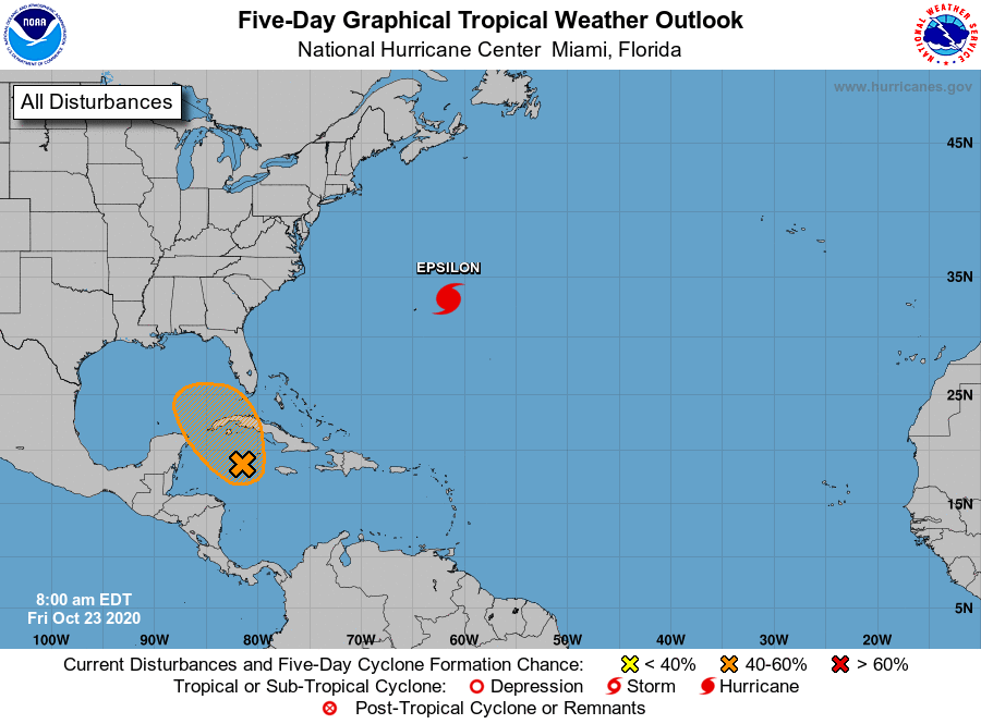
Hmm.. a very interesting 06Z run of the HMON. That run certainly is an interesting one for my neighbors down in South Florida. Just one run, but definitely one which warrants attention!
Last edited by northjaxpro on Fri Oct 23, 2020 7:25 am, edited 1 time in total.
2 likes
NEVER, EVER SAY NEVER in the tropics and weather in general, and most importantly, with life itself!!
________________________________________________________________________________________
Fay 2008 Beryl 2012 Debby 2012 Colin 2016 Hermine 2016 Julia 2016 Matthew 2016 Irma 2017 Dorian 2019
________________________________________________________________________________________
Fay 2008 Beryl 2012 Debby 2012 Colin 2016 Hermine 2016 Julia 2016 Matthew 2016 Irma 2017 Dorian 2019
-
Weatherboy1

- Category 5

- Posts: 1167
- Age: 48
- Joined: Mon Jul 05, 2004 1:50 pm
- Location: Jupiter, FL
Re: ATL: INVEST 95L - Discussion
Models may have been off-base on precise timing and/or pace of development. But clearly several runs had the general idea of something “popping” in this part of the Caribbean correct
3 likes
-
shiny-pebble
- Category 1

- Posts: 299
- Joined: Thu Jul 05, 2018 1:38 pm
Re: ATL: INVEST 95L - Discussion
I did not expect to wake up to this 
2 likes
Not an meteorologist! Just someone who is interested in weather. Please refer to the NHC and local weather officials to make decisions.
-Jack
-Jack

Re: ATL: INVEST 95L - Discussion
Good morning....... (grabbing coffee). "95L" Wait, what?????
9 likes
Personal Forecast Disclaimer:
The posts in this forum are NOT official forecast and should not be used as such. They are just the opinion of the poster and may or may not be backed by sound meteorological data. They are NOT endorsed by any professional institution or storm2k.org. For official information, please refer to the NHC and NWS products.
The posts in this forum are NOT official forecast and should not be used as such. They are just the opinion of the poster and may or may not be backed by sound meteorological data. They are NOT endorsed by any professional institution or storm2k.org. For official information, please refer to the NHC and NWS products.

Re: ATL: INVEST 95L - Discussion
northjaxpro wrote:Hmm.. a very interesting 06Z run of the HMON. That run certainly is an interesting one for my neighbors down in South Florida. Just one run, but definitely one which warrants attention!
Can you please post that run.
0 likes

Re: ATL: INVEST 95L - Discussion
boca wrote:northjaxpro wrote:Hmm.. a very interesting 06Z run of the HMON. That run certainly is an interesting one for my neighbors down in South Florida. Just one run, but definitely one which warrants attention!
Can you please post that run.
Boca its on the 95L models thread.
0 likes
-
northjaxpro
- S2K Supporter
- Posts: 8900
- Joined: Mon Sep 27, 2010 11:21 am
- Location: Jacksonville, FL
Re: ATL: INVEST 95L - Discussion
boca wrote:northjaxpro wrote:Hmm.. a very interesting 06Z run of the HMON. That run certainly is an interesting one for my neighbors down in South Florida. Just one run, but definitely one which warrants attention!
Can you please post that run.
It is already posted on the models thread Boca.
0 likes
NEVER, EVER SAY NEVER in the tropics and weather in general, and most importantly, with life itself!!
________________________________________________________________________________________
Fay 2008 Beryl 2012 Debby 2012 Colin 2016 Hermine 2016 Julia 2016 Matthew 2016 Irma 2017 Dorian 2019
________________________________________________________________________________________
Fay 2008 Beryl 2012 Debby 2012 Colin 2016 Hermine 2016 Julia 2016 Matthew 2016 Irma 2017 Dorian 2019

Re: ATL: INVEST 95L - Discussion
Salute!
Yeah, chaser, ditto from the PanHandle. Been hoping it would stay loose and head straight west, but.....
Looks like we may be saved by the front that is due in 2 or 3 days, but not looking so good for south FL.
Might be another Irene 99 or even Charley.
Gums sends...
Yeah, chaser, ditto from the PanHandle. Been hoping it would stay loose and head straight west, but.....
Looks like we may be saved by the front that is due in 2 or 3 days, but not looking so good for south FL.
Might be another Irene 99 or even Charley.
Gums sends...
1 likes
-
Emmett_Brown

- Category 5
- Posts: 1343
- Joined: Wed Aug 24, 2005 9:10 pm
- Location: Sarasota FL

Re: ATL: INVEST 95L - Discussion
Emmett_Brown wrote:Looks pretty healthy for a ghost
It is almost halloween after all.
2 likes


Re: ATL: INVEST 95L - Discussion
Looking at satellite, surface reports and radar from Cayman Islands I would the low pressure center is further south and east than its best track position at 8 AM.
Throw the 12z models out the window.
Throw the 12z models out the window.
0 likes
-
AutoPenalti
- Category 5
- Posts: 3950
- Age: 27
- Joined: Mon Aug 17, 2015 4:16 pm
- Location: Ft. Lauderdale, Florida
Re: ATL: INVEST 95L - Discussion
Epsilon was the wildcard with the models, once it weakened, all of the sudden this starts to develop, initially not having a trackable feature.
0 likes
The posts in this forum are NOT official forecasts and should not be used as such. They are just the opinion of the poster and may or may not be backed by sound meteorological data. They are NOT endorsed by any professional institution or STORM2K. For official information, please refer to products from the NHC and NWS.
Model Runs Cheat Sheet:
GFS (5:30 AM/PM, 11:30 AM/PM)
HWRF, GFDL, UKMET, NAVGEM (6:30-8:00 AM/PM, 12:30-2:00 AM/PM)
ECMWF (1:45 AM/PM)
TCVN is a weighted averaged

Re: ATL: INVEST 95L - Discussion
FINALLY, this is an Invest and we can put that 1,161 post thread out of its misery. Looking pretty good this morning.
5 likes
Irene '11 Sandy '12 Hermine '16 5/15/2018 Derecho Fay '20 Isaias '20 Elsa '21 Henri '21 Ida '21
I am only a meteorology enthusiast who knows a decent amount about tropical cyclones. Look to the professional mets, the NHC, or your local weather office for the best information.
I am only a meteorology enthusiast who knows a decent amount about tropical cyclones. Look to the professional mets, the NHC, or your local weather office for the best information.

Re: ATL: INVEST 95L - Discussion
jconsor wrote:https://twitter.com/yconsor/status/1319621396964790273
But it also started it further south. This is consistent with where the GFS thought the development would be at this time before it lost the development. Look at the trend for this verification time. Tropical Tidbits only goes back a week, so its possible that it was different before this though.
https://ibb.co/d4pnBNn
Last edited by tomatkins on Fri Oct 23, 2020 8:13 am, edited 2 times in total.
0 likes
-
TallyTracker
- Category 2

- Posts: 585
- Joined: Thu Oct 11, 2018 2:46 pm
Re: ATL: INVEST 95L - Discussion
Wow did not expect to see that coming toward me this morning!  Gotta love the way the tropics can throw you a curveball!
Gotta love the way the tropics can throw you a curveball!
0 likes
Fran '96, Georges '98, Gordon '00, Gabrielle '01, Charley '04, Frances '04, Jeanne '04, Barry '07, Fay '08, Debby '12, Matthew '16, Emily '17, Irma '17, Michael ‘18, Elsa ‘21, Fred ‘21, Mindy ‘21, Nicole ‘22, Idalia ‘23
Re: ATL: INVEST 95L - Discussion
95L has written the FL Panhandle all over it by mid to late next week. Ridge moving over FL early next week will protect S FL, at least from a direct impact. IMO.
0 likes
Who is online
Users browsing this forum: No registered users and 4 guests