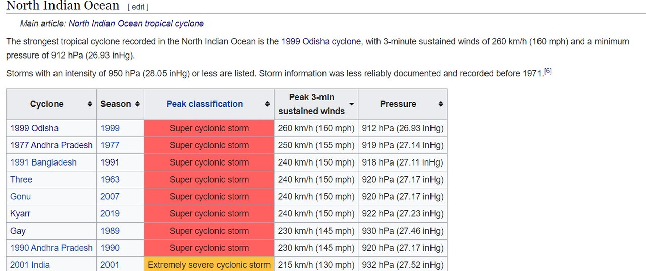
BoB: AMPHAN - Post-Tropical

Moderator: S2k Moderators

Message
Author
User avatar
aspen
Category 5
Category 5
Posts: 8057
Joined: Sat Oct 12, 2019 7:10 pm
Location: Connecticut, USA

Re: BoB: AMPHAN - Super Cyclonic Storm

#281 Postby aspen » Mon May 18, 2020 7:48 am

Nancy Smar wrote:
01B AMPHAN 200518 1200 14.0N 86.3E IO 145 901

Called it, but I’m genuinely surprised the JTWC actually went with that. They’ve been doing a great job with Amphan so far.
0 likes   
Irene '11 Sandy '12 Hermine '16 5/15/2018 Derecho Fay '20 Isaias '20 Elsa '21 Henri '21 Ida '21

I am only a meteorology enthusiast who knows a decent amount about tropical cyclones. Look to the professional mets, the NHC, or your local weather office for the best information.

User avatar
Hypercane_Kyle
Category 5
Category 5
Posts: 2899
Joined: Sat Mar 07, 2015 7:58 pm
Location: Cape Canaveral, FL

Re: BoB: AMPHAN - Super Cyclonic Storm

#282 Postby Hypercane_Kyle » Mon May 18, 2020 7:51 am

Amphan is now the strongest cyclone ever recorded in the Bay of Bengal, beating out the 1999 storm by a significant margin.
0 likes   
My posts are my own personal opinion, defer to the National Hurricane Center (NHC) and other NOAA products for decision making during hurricane season.

MarioProtVI
Category 2
Category 2
Posts: 670
Age: 22
Joined: Sun Sep 29, 2019 7:33 pm
Location: New Jersey

Re: BoB: AMPHAN - Super Cyclonic Storm

#283 Postby MarioProtVI » Mon May 18, 2020 7:57 am

Hypercane_Kyle wrote:Amphan is now the strongest cyclone ever recorded in the Bay of Bengal, beating out the 1999 storm by a significant margin.

Not yet, you’re going by the JTWC’s pressure (901), which even though I think is a reasonable guess, it is overridden by the IMD (the RSMC of this basin), who has it at 930 pending 12z update which will probably drop to ~920 or so.


This is really shaping up to be the worst storm to impact Bangladesh since then and could potentially kill thousands if preparations are not taken into action. We can only hope it somehow strikes a sparsely popular area that causes few fatalities.
3 likes   

User avatar
aspen
Category 5
Category 5
Posts: 8057
Joined: Sat Oct 12, 2019 7:10 pm
Location: Connecticut, USA

Re: BoB: AMPHAN - Super Cyclonic Storm

#284 Postby aspen » Mon May 18, 2020 8:04 am

Hypercane_Kyle wrote:Amphan is now the strongest cyclone ever recorded in the Bay of Bengal, beating out the 1999 storm by a significant margin.

I think I heard about a re-analysis of the Odisha cyclone suggesting it had winds of ~155 kt, so it might’ve been even stronger than Amphan is now.
0 likes   
Irene '11 Sandy '12 Hermine '16 5/15/2018 Derecho Fay '20 Isaias '20 Elsa '21 Henri '21 Ida '21

I am only a meteorology enthusiast who knows a decent amount about tropical cyclones. Look to the professional mets, the NHC, or your local weather office for the best information.

User avatar
mrbagyo
Category 5
Category 5
Posts: 3614
Age: 31
Joined: Thu Apr 12, 2012 9:18 am
Location: 14.13N 120.98E
Contact:

Re: BoB: AMPHAN - Super Cyclonic Storm

#285 Postby mrbagyo » Mon May 18, 2020 8:22 am

Image

Triple concentric eyewall?
This EWRC would further increase the radius of maximum wind.
2 likes   
The posts in this forum are NOT official forecast and should not be used as such. They are just the opinion of the poster and may or may not be backed by sound meteorological data. They are NOT endorsed by any professional institution or storm2k.org. For official information, please refer to RSMC, NHC and NWS products.

User avatar
aspen
Category 5
Category 5
Posts: 8057
Joined: Sat Oct 12, 2019 7:10 pm
Location: Connecticut, USA

Re: BoB: AMPHAN - Super Cyclonic Storm

#286 Postby aspen » Mon May 18, 2020 8:26 am

:uarrow: Perhaps the partial third eyewall will blend into the second. That’s what seems to be happening to me.
0 likes   
Irene '11 Sandy '12 Hermine '16 5/15/2018 Derecho Fay '20 Isaias '20 Elsa '21 Henri '21 Ida '21

I am only a meteorology enthusiast who knows a decent amount about tropical cyclones. Look to the professional mets, the NHC, or your local weather office for the best information.

User avatar
Crostorm
Category 5
Category 5
Posts: 2060
Age: 49
Joined: Mon Dec 25, 2006 3:51 pm
Location: Croatia-Europe
Contact:

Re: BoB: AMPHAN - Super Cyclonic Storm

#287 Postby Crostorm » Mon May 18, 2020 8:29 am

Image
0 likes   

al78
Professional-Met
Professional-Met
Posts: 249
Joined: Thu Nov 01, 2018 12:20 pm

Re: BoB: AMPHAN - Super Cyclonic Storm

#288 Postby al78 » Mon May 18, 2020 8:48 am

An eyewall replacement cycle can be a double edged sword. It lowers the peak wind, but can also increase the radius of damaging winds, which in itself increases the height of the storm surge. I recall this happened with Katrina in 2005, it weakened from cat 5 to cat 3 at landfall but the breadth of the storm grew considerably, and the peak storm surge was near 30 ft.

Does anyone know how effective the cyclone warning and evacuation systems are in the Ganges delta, and what tghe capacity of the shelters is compared to the number under threat?
2 likes   

User avatar
doomhaMwx
Category 5
Category 5
Posts: 2398
Age: 25
Joined: Tue Apr 18, 2017 4:01 am
Location: Baguio/Benguet, Philippines
Contact:

Re: BoB: AMPHAN - Super Cyclonic Storm

#289 Postby doomhaMwx » Mon May 18, 2020 8:57 am

VIS satellite shot at sunset
05-18-2020 11:45am UTC

Image
Image
4 likes   
Like my content? Consider giving a tip.

User avatar
Yellow Evan
Professional-Met
Professional-Met
Posts: 15951
Age: 25
Joined: Fri Jul 15, 2011 12:48 pm
Location: Henderson, Nevada/Honolulu, HI
Contact:

Re: BoB: AMPHAN - Super Cyclonic Storm

#290 Postby Yellow Evan » Mon May 18, 2020 9:16 am

2020MAY18 001500 5.5 950.8 102.0 5.5 5.7 6.8 1.7T/6hr OFF OFF OFF OFF -44.87 -85.71 EYE -99 IR -15.5 13.25 -86.44 ARCHER MSG1 53.4
2020MAY18 004500 5.5 950.8 102.0 5.5 5.8 6.8 1.7T/6hr OFF OFF OFF OFF -44.29 -85.22 EYE -99 IR 70.9 13.25 -86.42 ARCHER MSG1 53.3
2020MAY18 011500 5.7 942.3 107.2 5.7 6.1 6.9 1.7T/6hr OFF OFF OFF OFF -41.20 -85.18 EYE 7 IR 70.9 13.26 -86.41 ARCHER MSG1 53.3
2020MAY18 014500 5.7 942.3 107.2 5.7 6.2 6.9 1.7T/6hr OFF OFF OFF OFF -36.21 -84.72 EYE 9 IR 70.9 13.27 -86.38 ARCHER MSG1 53.3
2020MAY18 021500 5.9 937.7 112.4 5.9 6.4 6.9 1.7T/6hr OFF OFF OFF OFF -39.05 -84.34 EYE 8 IR 70.9 13.31 -86.40 ARCHER MSG1 53.3
2020MAY18 024500 6.1 933.1 117.4 6.1 6.6 6.9 1.7T/6hr OFF OFF OFF OFF -34.46 -84.31 EYE 9 IR 70.9 13.33 -86.35 ARCHER MSG1 53.3
2020MAY18 031500 6.2 930.9 119.8 6.2 6.4 6.7 2.7T/12hr OFF OFF OFF OFF -50.03 -83.96 EYE -99 IR 70.9 13.35 -86.40 ARCHER MSG1 53.4
2020MAY18 034500 6.2 930.9 119.8 6.2 6.4 6.7 2.7T/12hr OFF OFF OFF OFF -47.24 -83.92 EYE -99 IR 70.9 13.37 -86.38 ARCHER MSG1 53.3
2020MAY18 041500 6.3 928.6 122.2 6.3 6.5 6.6 2.7T/12hr OFF OFF OFF OFF -55.38 -83.61 EYE -99 IR 70.9 13.44 -86.40 ARCHER MSG1 53.4
2020MAY18 044500 6.4 926.3 124.6 6.4 6.5 6.6 2.7T/12hr OFF OFF OFF OFF -54.33 -83.34 EYE -99 IR 70.9 13.45 -86.38 ARCHER MSG1 53.4
2020MAY18 051500 6.4 926.3 124.6 6.4 6.6 6.6 NO LIMIT OFF OFF OFF OFF -51.65 -83.33 EYE -99 IR 70.9 13.50 -86.36 ARCHER MSG1 53.3
2020MAY18 054500 6.5 924.0 127.0 6.5 6.6 6.7 2.7T/12hr OFF OFF OFF OFF -46.04 -83.49 EYE -99 IR 70.9 13.52 -86.31 ARCHER MSG1 53.3
2020MAY18 061500 6.5 924.0 127.0 6.5 6.7 6.9 2.7T/12hr OFF OFF OFF OFF -36.46 -84.25 EYE -99 IR 70.9 13.48 -86.31 ARCHER MSG1 53.3
2020MAY18 064500 6.5 924.0 127.0 6.5 6.8 6.9 2.7T/12hr OFF OFF OFF OFF -35.96 -84.32 EYE 8 IR 71.3 13.58 -86.31 ARCHER MSG1 53.3
2020MAY18 071500 6.6 923.2 129.6 6.6 6.8 6.8 NO LIMIT OFF OFF OFF OFF -42.86 -84.13 EYE 7 IR 71.3 13.52 -86.35 ARCHER MSG1 53.3
2020MAY18 074500 6.7 920.6 132.2 6.7 6.9 6.9 NO LIMIT OFF OFF OFF OFF -38.00 -84.32 EYE 8 IR 71.3 13.66 -86.38 ARCHER MSG1 53.4
2020MAY18 081500 6.7 920.6 132.2 6.7 6.9 6.9 NO LIMIT OFF OFF OFF OFF -33.25 -84.36 EYE 9 IR 71.3 13.62 -86.35 ARCHER MSG1 53.4
2020MAY18 084500 6.8 918.1 134.8 6.8 6.9 7.0 3.2T/18hr OFF OFF OFF OFF -30.41 -84.58 EYE 9 IR 71.3 13.65 -86.39 ARCHER MSG1 53.4
2020MAY18 091500 6.8 918.0 134.8 6.8 6.7 6.7 NO LIMIT OFF OFF OFF OFF -49.40 -84.53 EYE -99 IR 71.3 13.75 -86.48 ARCHER MSG1 53.5
2020MAY18 094500 6.8 918.0 134.8 6.8 6.9 7.0 3.2T/18hr OFF OFF OFF OFF -30.41 -84.14 EYE 11 IR 71.3 13.80 -86.44 ARCHER MSG1 53.5
2020MAY18 101500 6.8 918.0 134.8 6.8 7.0 7.1 3.2T/18hr OFF OFF OFF OFF -19.49 -83.20 EYE 10 IR 71.3 13.81 -86.46 ARCHER MSG1 53.5
2020MAY18 104500 6.8 918.0 134.8 6.8 6.9 6.9 NO LIMIT OFF OFF OFF OFF -23.58 -82.22 EYE 11 IR 14.8 13.88 -86.49 ARCHER MSG1 53.6
2020MAY18 111500 6.9 915.4 137.4 6.9 7.1 7.2 3.2T/18hr OFF OFF OFF OFF -6.82 -81.74 EYE 12 IR 39.0 13.91 -86.53 ARCHER MSG1 53.6
2020MAY18 114500 6.9 915.4 137.4 6.9 7.0 7.0 NO LIMIT OFF OFF OFF OFF -15.04 -81.47 EYE 14 IR 39.0 14.01 -86.59 ARCHER MSG1 53.7
2020MAY18 121500 7.0 912.7 140.0 7.0 7.2 7.2 NO LIMIT OFF OFF OFF OFF -4.47 -81.58 EYE 14 IR 39.0 14.07 -86.55 ARCHER MSG1 53.7
2020MAY18 124500 7.0 912.7 140.0 7.0 7.2 7.2 NO LIMIT OFF OFF OFF OFF -3.31 -82.00 EYE 15 IR 39.0 14.12 -86.59 ARCHER MSG1 53.7
2020MAY18 131500 7.0 910.7 140.0 7.0 7.2 7.2 NO LIMIT OFF OFF OFF OFF -2.66 -81.54 EYE 12 IR 39.0 14.20 -86.62 ARCHER MSG1 53.8
2020MAY18 134500 7.1 907.6 143.0 7.1 6.9 6.9 NO LIMIT OFF OFF OFF OFF -14.29 -80.22 EYE 12 IR 39.0 14.29 -86.62 ARCHER MSG1 53.8
Utilizing history file /data2/misc/ADTV9.0/scripts/history/01B.ODT
Successfully completed listing
0 likes   

User avatar
Yellow Evan
Professional-Met
Professional-Met
Posts: 15951
Age: 25
Joined: Fri Jul 15, 2011 12:48 pm
Location: Henderson, Nevada/Honolulu, HI
Contact:

Re: BoB: AMPHAN - Super Cyclonic Storm

#291 Postby Yellow Evan » Mon May 18, 2020 9:18 am

Image

Old but ERC progressing. Still badass that the eye managed to warm during it though.
0 likes   

User avatar
1900hurricane
Category 5
Category 5
Posts: 6044
Age: 32
Joined: Fri Feb 06, 2015 12:04 pm
Location: Houston, TX
Contact:

Re: BoB: AMPHAN - Super Cyclonic Storm

#292 Postby 1900hurricane » Mon May 18, 2020 9:25 am

Port Blair, Nicobar Islands 12Z sounding. Classic tropical profile featuring a tropopause/EL higher than 100 mb.

Image
3 likes   
Contract Meteorologist. TAMU & MSST. Fiercely authentic, one of a kind. We are all given free will, so choose a life meant to be lived. We are the Masters of our own Stories.
Opinions expressed are mine alone.

Follow me on Twitter at @1900hurricane : Read blogs at https://1900hurricane.wordpress.com/

User avatar
doomhaMwx
Category 5
Category 5
Posts: 2398
Age: 25
Joined: Tue Apr 18, 2017 4:01 am
Location: Baguio/Benguet, Philippines
Contact:

Re: BoB: AMPHAN - Super Cyclonic Storm

#293 Postby doomhaMwx » Mon May 18, 2020 9:34 am

150kts peak huh

Image
0 likes   
Like my content? Consider giving a tip.

User avatar
mrbagyo
Category 5
Category 5
Posts: 3614
Age: 31
Joined: Thu Apr 12, 2012 9:18 am
Location: 14.13N 120.98E
Contact:

Re: BoB: AMPHAN - Super Cyclonic Storm

#294 Postby mrbagyo » Mon May 18, 2020 9:42 am

Russia's Elektro-L2 satellite this past morning

Image
4 likes   
The posts in this forum are NOT official forecast and should not be used as such. They are just the opinion of the poster and may or may not be backed by sound meteorological data. They are NOT endorsed by any professional institution or storm2k.org. For official information, please refer to RSMC, NHC and NWS products.

User avatar
Yellow Evan
Professional-Met
Professional-Met
Posts: 15951
Age: 25
Joined: Fri Jul 15, 2011 12:48 pm
Location: Henderson, Nevada/Honolulu, HI
Contact:

Re: BoB: AMPHAN - Super Cyclonic Storm

#295 Postby Yellow Evan » Mon May 18, 2020 9:47 am

2 likes   

NotoSans
Category 5
Category 5
Posts: 1366
Age: 24
Joined: Sun Sep 27, 2015 1:15 am
Location: Hong Kong
Contact:

Re: BoB: AMPHAN - Super Cyclonic Storm

#296 Postby NotoSans » Mon May 18, 2020 11:01 am

2 likes   
Personal Forecast Disclaimer:
The posts in this forum are NOT official forecast and should not be used as such. They are just the opinion of the poster and may or may not be backed by sound meteorological data. They are NOT endorsed by any professional institution or storm2k.org. For official information, please refer to RSMC and NWS products.

User avatar
Hayabusa
Category 5
Category 5
Posts: 3738
Joined: Sun Sep 16, 2018 1:05 pm

Re: BoB: AMPHAN - Super Cyclonic Storm

#297 Postby Hayabusa » Mon May 18, 2020 11:15 am

UK init at 894 mb

Image

Image
2 likes   
ヤンデレ女が寝取られるているのを見たい!!!
ECMWF ensemble NWPAC plots: https://ecmwfensnwpac.imgbb.com/
Multimodel NWPAC plots: https://multimodelnwpac.imgbb.com/
GFS Ensemble NWPAC plots (16 & 35 day forecast): https://gefsnwpac.imgbb.com/
Plots updated automatically

User avatar
mrbagyo
Category 5
Category 5
Posts: 3614
Age: 31
Joined: Thu Apr 12, 2012 9:18 am
Location: 14.13N 120.98E
Contact:

Re: BoB: AMPHAN - Super Cyclonic Storm

#298 Postby mrbagyo » Mon May 18, 2020 11:47 am


That UKMET model track is almost a noontime landfall (local time)

Image

Noontime = maximum surge
0 likes   
The posts in this forum are NOT official forecast and should not be used as such. They are just the opinion of the poster and may or may not be backed by sound meteorological data. They are NOT endorsed by any professional institution or storm2k.org. For official information, please refer to RSMC, NHC and NWS products.

User avatar
Jr0d
S2K Supporter
S2K Supporter
Posts: 1174
Joined: Tue Aug 27, 2019 10:52 am
Location: Cayo Hueso

Re: BoB: AMPHAN - Super Cyclonic Storm

#299 Postby Jr0d » Mon May 18, 2020 12:32 pm

A slight wobble can make a huge difference. If Amphan goes a little east and the Hooghly River is west side of the storm, the surge will be significantly lower or even suck water out lowering the river/sea level.

A little more of an easterly track, the Hooghly River will have a devastating surge that will affect Kolkata.

The best case scenerio will be for the worst of the storm to impact the Sundarban refuge. This still will bring surges up the rivers and into the villages in Bangladesh.

I hope the warnings are getting out and the locals are taking the necessary steps to protect themselves.
2 likes   

User avatar
aspen
Category 5
Category 5
Posts: 8057
Joined: Sat Oct 12, 2019 7:10 pm
Location: Connecticut, USA

Re: BoB: AMPHAN - Super Cyclonic Storm

#300 Postby aspen » Mon May 18, 2020 12:33 pm

Low-res microwave pass from 14z shows the EWRC well in effect:
Image
0 likes   
Irene '11 Sandy '12 Hermine '16 5/15/2018 Derecho Fay '20 Isaias '20 Elsa '21 Henri '21 Ida '21

I am only a meteorology enthusiast who knows a decent amount about tropical cyclones. Look to the professional mets, the NHC, or your local weather office for the best information.


Return to “2020”

Who is online

Users browsing this forum: No registered users and 69 guests