ATL: CRISTOBAL - Models
Moderator: S2k Moderators
- gatorcane
- S2K Supporter

- Posts: 23499
- Age: 46
- Joined: Sun Mar 13, 2005 3:54 pm
- Location: Boca Raton, FL
Re: ATL: THREE - Models
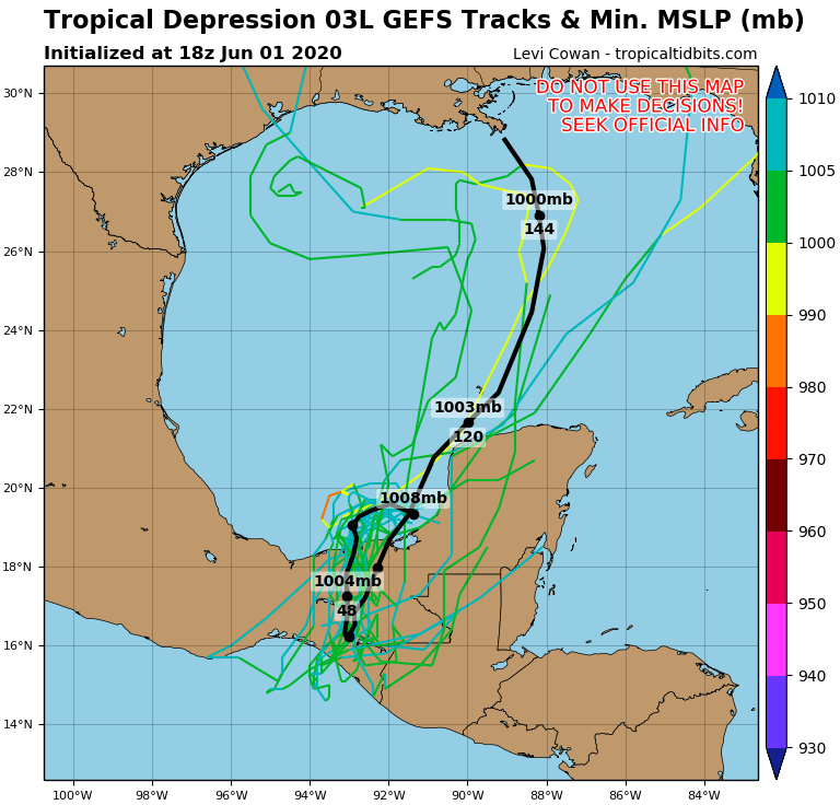
18Z GFS ensembles have a huge spread from as far east as just north of Tampa, FL and as far west as Houston, Texas


1 likes
-
Aric Dunn
- Category 5

- Posts: 21228
- Age: 41
- Joined: Sun Sep 19, 2004 9:58 pm
- Location: Ready for the Chase.
- Contact:
Re: ATL: THREE - Models
notice besides the silly GFS.
the cyclonic loops is becoming less pronounced.
each run it is smaller and tighter and not as far west..
means there is less GYRE motion interaction. which will equal to more meandering ... also notice TD3 has not moved all that much to the wnw. when at this point all the models had to booging through the cyclonic loop..
expect things to align more with not moving over mexico.
2 likes
Note: If I make a post that is brief. Please refer back to previous posts for the analysis or reasoning. I do not re-write/qoute what my initial post said each time.
If there is nothing before... then just ask
Space & Atmospheric Physicist, Embry-Riddle Aeronautical University,
I believe the sky is falling...
If there is nothing before... then just ask
Space & Atmospheric Physicist, Embry-Riddle Aeronautical University,
I believe the sky is falling...
- cycloneye
- Admin

- Posts: 139080
- Age: 67
- Joined: Thu Oct 10, 2002 10:54 am
- Location: San Juan, Puerto Rico
Re: ATL: THREE - Models
0 likes
Visit the Caribbean-Central America Weather Thread where you can find at first post web cams,radars
and observations from Caribbean basin members Click Here
and observations from Caribbean basin members Click Here
-
stormlover2013
- Category 5

- Posts: 2312
- Joined: Thu Aug 22, 2013 12:06 pm
- Location: Lumberton, Texas
Re: ATL: THREE - Models
cycloneye wrote:https://twitter.com/BigJoeBastardi/status/1267627779849420812
So anywhere from strong TS to possible Cat 3, if those pressures pan out, great no idea what to expect.
0 likes
Personal Forecast Disclaimer:
The posts in this forum are NOT official forecast and should not be used as such. They are just the opinion of the poster and may or may not be backed by sound meteorological data. They are NOT endorsed by any professional institution or storm2k.org. For official information, please refer to the NHC and NWS products.
The posts in this forum are NOT official forecast and should not be used as such. They are just the opinion of the poster and may or may not be backed by sound meteorological data. They are NOT endorsed by any professional institution or storm2k.org. For official information, please refer to the NHC and NWS products.
Re: ATL: THREE - Models
NAM 12km still has it spinning in the Bay of Campeche possibly beginning to lift at the end of it's 84 hour run (valid 7am Friday). If that's the case, maybe we will have a clear idea of track or not. But it would seem like Sunday/Monday could be the earliest anything could landfall along the North Gulf Coast (could get to S/SETX quicker if it doesn't initially move North or Northeast before (if) it begins to move off to the NW. It would probably be more like late Monday/Tuesday unless the forward motion was faster than 10-12mph or so (I didn't do the math, just based on mental estimates). This bears out in Beven's 120 hour position which still has it at 22.5N. Most of the North Gulf is 29/30ish.
Of course 20 degrees North is out of the NAM's range, and you don't look to it for genesis anyway. But the spin is recognizable.
Of course 20 degrees North is out of the NAM's range, and you don't look to it for genesis anyway. But the spin is recognizable.
1 likes
- TheProfessor
- Professional-Met

- Posts: 3505
- Age: 27
- Joined: Tue Dec 03, 2013 10:56 am
- Location: Wichita, Kansas
Re: ATL: THREE - Models
0z ICON a touch southeast of it's 18z run, it's keeping it very close, but just off the coast so far.
1 likes
An alumnus of The Ohio State University.
Your local National Weather Service office is your best source for weather information.
Your local National Weather Service office is your best source for weather information.
- TheProfessor
- Professional-Met

- Posts: 3505
- Age: 27
- Joined: Tue Dec 03, 2013 10:56 am
- Location: Wichita, Kansas
Re: ATL: THREE - Models
0z ICON ends up being a bit east of the 18z run through hour 114 and then begins to bend west as it approaches the Louisiana coast and then eventually landfalls near Galveston.
1 likes
An alumnus of The Ohio State University.
Your local National Weather Service office is your best source for weather information.
Your local National Weather Service office is your best source for weather information.
Re: ATL: THREE - Models
Every mile counts and every hour counts, I wouldn't pay too much attention to models past 24 hrs, just 3 days ago the GFS was showing the system to be on EPAC side tomorrow night.


7 likes
Re: ATL: THREE - Models
TheProfessor wrote:0z ICON ends up being a bit east of the 18z run through hour 114 and then begins to bend west as it approaches the Louisiana coast and then eventually landfalls near Galveston.
It's generally shown this to be a fairly concentric and tight system. Landfall looks to be around midnight Sunday night/monday morning, 970's Galveston. Most of the weather is in the Gulf. One benchmark is 96 hours (7pm Friday night CDT) where the core is just to the NW tip of the Yucatan after moving jaggedly up the coast.
1 likes
-
floridasun78
- Category 5

- Posts: 3755
- Joined: Sun May 17, 2009 10:16 pm
- Location: miami fl
Re: ATL: THREE - Models
new gfs have new low form nw carribbean and low in boc get pull south weaking but still loading (( update now their no low with td3 so look like die over Yucatán Peninsula ))
1 likes
Re: ATL: THREE - Models
GFS is a little sloppier and slower than the ICON to the NW Tip of the Yuctan by about 6 hours. It's currently out to 126hours (1am Sunday morning) 25.7/90.7 +/-. That's due south of Houma, LA and still slightly south of the TX/Mex border. Large shield of reds just off the LA Coast. Obviously you don't want that rotating through on an E to W trajectory.
Up to 138 hours, it looks like the GFS really doesn't get this that strong. Appears that the center is doing that top wobbling thing (can't ever remember what they call it) and keeps it in the 990's at least through now. Appears to be just south of Grand Isle with the heaviest shields across SELA over to St. George or so throughout. Will be interesting to see what the total rainfall it shows is as well as whether it comes north or moves off to the west.
Up to 138 hours, it looks like the GFS really doesn't get this that strong. Appears that the center is doing that top wobbling thing (can't ever remember what they call it) and keeps it in the 990's at least through now. Appears to be just south of Grand Isle with the heaviest shields across SELA over to St. George or so throughout. Will be interesting to see what the total rainfall it shows is as well as whether it comes north or moves off to the west.
0 likes
Re: ATL: THREE - Models
GFS goes into Abbeville 7am Monday morning and then moves north up through the Piney Woods. Through 186 hours, the most rain shown is around Apalachicola.
https://www.tropicaltidbits.com/analysi ... 200&fh=204
https://www.tropicaltidbits.com/analysi ... 200&fh=204
0 likes
-
Astromanía
- Category 2

- Posts: 737
- Age: 25
- Joined: Sat Aug 25, 2018 10:34 pm
- Location: Monterrey, N.L, México
Re: ATL: THREE - Models
GFS is a little sloppier and slower than the ICON to the NW Tip of the Yuctan by about 6 hours. It's currently out to 126hours (1am Sunday morning) 25.7/90.7 +/-. That's due south of Houma, LA and still slightly south of the TX/Mex border. Large shield of reds just off the LA Coast. Obviously you don't want that rotating through on an E to W trajectory.
0 likes
Re: ATL: THREE - Models
CMC has gotten substantively better over the last season or two. It's slightly faster than ICON at 96 hours and has it a bit NW of where ICON is progged to be then, but close to the intensity that GFS has all the way at landfall whereas CMC is only at about 22.5N. CMC is at about 998 at this point whereas GFS is like 997 at landfall. So the CMC will probably get stronger. Let's see where it goes.
1 likes
-
stormlover2013
- Category 5

- Posts: 2312
- Joined: Thu Aug 22, 2013 12:06 pm
- Location: Lumberton, Texas
Re: ATL: THREE - Models
https://www.tropicaltidbits.com/analysi ... 0200&fh=18
HWRF has it stronger in 18 hours than GFS does at Landfall in SWLA next week. Haha. I don't know if it'll be 994 tomorrow afternoon, and the HWRF can be aggressive. But it's running now. Will check on CMC in a minute, but I'm probably not staying up for the European.
HWRF has it stronger in 18 hours than GFS does at Landfall in SWLA next week. Haha. I don't know if it'll be 994 tomorrow afternoon, and the HWRF can be aggressive. But it's running now. Will check on CMC in a minute, but I'm probably not staying up for the European.
0 likes
Re: ATL: THREE - Models
CMC almost mirrors the GFS in track and intensity hitting around Abbeville/Vermilion Bay/Pecan Island about 1:00am Monday morning as a 996 on simulated radar (GFS landfalls around 997). So slightly faster than GFS but it's hard to tell for sure on 6 hour plots.
https://www.tropicaltidbits.com/analysi ... 200&fh=150
https://www.tropicaltidbits.com/analysi ... 200&fh=150
Last edited by Steve on Mon Jun 01, 2020 11:57 pm, edited 1 time in total.
0 likes
-
Wx_Warrior
- Category 5

- Posts: 2718
- Joined: Thu Aug 03, 2006 3:58 pm
- Location: Beaumont, TX
Re: ATL: THREE - Models
Hate to get OT, but real question for admins / can you mute people on here like FB unfollow & Twitter mute ???
0 likes
Who is online
Users browsing this forum: No registered users and 73 guests

