ATL: DOLLY - Remnants

Moderator: S2k Moderators

Message
Author
User avatar
Nancy Smar
Category 5
Category 5
Posts: 1081
Age: 23
Joined: Wed Aug 16, 2017 10:03 pm

ATL: DOLLY - Remnants

#1 Postby Nancy Smar » Sun Jun 21, 2020 9:57 am

AL, 95, 2020062112, , BEST, 0, 366N, 678W, 25, 1013, LO, 34, NEQ, 0, 0, 0, 0, 1016, 180, 60, 0, 0, L, 0, , 0, 0, INVEST, S, 0, , 0, 0, 0, 0, genesis-num, 011, SPAWNINVEST, al722020 to al952020,


Thread at Talking Tropics forum that was the topic for this area.

viewtopic.php?f=31&t=120952&p=2807785#p2807785
Last edited by Nancy Smar on Tue Jun 23, 2020 11:16 am, edited 2 times in total.
0 likes   

User avatar
cainjamin
Tropical Storm
Tropical Storm
Posts: 161
Age: 33
Joined: Mon Apr 17, 2017 1:38 pm
Location: Nova Scotia, Canada

Re: ATL: INVEST 95L - Discussion

#2 Postby cainjamin » Sun Jun 21, 2020 10:19 am

I wouldn't be surprised if this sneaks up on us into a subtropical storm. Looking a lot like Andrea from last year already.
0 likes   
Noel '07, Kyle '08, Earl '10, Arthur '14, Dorian '19, Teddy '20, Lee '23

MarioProtVI
Category 2
Category 2
Posts: 670
Age: 22
Joined: Sun Sep 29, 2019 7:33 pm
Location: New Jersey

Re: ATL: INVEST 95L - Discussion

#3 Postby MarioProtVI » Sun Jun 21, 2020 10:22 am

Image
LLC trying to consolidate near ~37.5N ~67.5W. Maybe brief SD 4?
1 likes   

User avatar
AnnularCane
S2K Supporter
S2K Supporter
Posts: 2634
Joined: Thu Jun 08, 2006 9:18 am
Location: Wytheville, VA

Re: ATL: INVEST 95L - Discussion

#4 Postby AnnularCane » Sun Jun 21, 2020 10:25 am

Awwww, look at that pretty little thing. 8-)
0 likes   

User avatar
cainjamin
Tropical Storm
Tropical Storm
Posts: 161
Age: 33
Joined: Mon Apr 17, 2017 1:38 pm
Location: Nova Scotia, Canada

Re: ATL: INVEST 95L - Discussion

#5 Postby cainjamin » Sun Jun 21, 2020 11:24 am

Image

Convection is popping near the LLC. Probably feeling the effects of the Gulf Stream underneath it.
0 likes   
Noel '07, Kyle '08, Earl '10, Arthur '14, Dorian '19, Teddy '20, Lee '23

User avatar
cainjamin
Tropical Storm
Tropical Storm
Posts: 161
Age: 33
Joined: Mon Apr 17, 2017 1:38 pm
Location: Nova Scotia, Canada

Re: ATL: INVEST 95L - Discussion

#6 Postby cainjamin » Sun Jun 21, 2020 11:34 am

Lots of little vortexes rotating around the dominant LLC. It will be interesting to see if the bursting convection can tighten it up a little more.
0 likes   
Noel '07, Kyle '08, Earl '10, Arthur '14, Dorian '19, Teddy '20, Lee '23

User avatar
mrbagyo
Category 5
Category 5
Posts: 3614
Age: 31
Joined: Thu Apr 12, 2012 9:18 am
Location: 14.13N 120.98E
Contact:

Re: ATL: INVEST 95L - Discussion

#7 Postby mrbagyo » Sun Jun 21, 2020 12:15 pm

Image
5 likes   
The posts in this forum are NOT official forecast and should not be used as such. They are just the opinion of the poster and may or may not be backed by sound meteorological data. They are NOT endorsed by any professional institution or storm2k.org. For official information, please refer to RSMC, NHC and NWS products.

User avatar
Extratropical94
Professional-Met
Professional-Met
Posts: 3535
Age: 29
Joined: Wed Oct 20, 2010 6:36 am
Location: Hamburg, Germany
Contact:

Re: ATL: INVEST 95L - Discussion

#8 Postby Extratropical94 » Sun Jun 21, 2020 12:37 pm

Tropical Weather Outlook
NWS National Hurricane Center Miami FL
200 PM EDT Sun Jun 21 2020

For the North Atlantic...Caribbean Sea and the Gulf of Mexico:

A well-defined, non-tropical low pressure system is located about
300 miles southeast of Cape Cod, Massachusetts. Showers and
thunderstorms have recently become a little better organized near
the center, and the system could briefly acquire subtropical
characteristics tonight and early Monday while the low moves
northeastward over the warm waters of the Gulfstream. By Monday
night and Tuesday, however, the system is expected to weaken when
it moves back over the cooler waters of the North Atlantic.
* Formation chance through 48 hours...medium...40 percent.
* Formation chance through 5 days...medium...40 percent.
0 likes   
54° 11' 59'' N, 9° 9' 20'' E
Boomer Sooner!
Go Broncos! Go Cards! Go Niners!
- Daniel

User avatar
EquusStorm
Category 5
Category 5
Posts: 1649
Age: 33
Joined: Thu Nov 07, 2013 1:04 pm
Location: Jasper, AL
Contact:

Re: ATL: INVEST 95L - Discussion

#9 Postby EquusStorm » Sun Jun 21, 2020 3:36 pm

Well that's getting awfully close, have seen worse looking systems classified. Even a massive SAL outbreak isn't slowing things down as much as one would assume with these higher latitude things spinning up
0 likes   
Colors of lost purpose on the canvas of irrelevance

Not a meteorologist, in fact more of an idiot than anything. You should probably check with the NHC or a local NWS office for official information.

User avatar
aspen
Category 5
Category 5
Posts: 8057
Joined: Sat Oct 12, 2019 7:10 pm
Location: Connecticut, USA

Re: ATL: INVEST 95L - Discussion

#10 Postby aspen » Sun Jun 21, 2020 4:44 pm

The circulation is quite broad, but it’s decently defined and hot towers keep popping up near the center from time to time. If it keeps this up, we probably will have a STC tomorrow.
0 likes   
Irene '11 Sandy '12 Hermine '16 5/15/2018 Derecho Fay '20 Isaias '20 Elsa '21 Henri '21 Ida '21

I am only a meteorology enthusiast who knows a decent amount about tropical cyclones. Look to the professional mets, the NHC, or your local weather office for the best information.

User avatar
TheStormExpert
Category 5
Category 5
Posts: 8487
Age: 30
Joined: Wed Feb 16, 2011 5:38 pm
Location: Palm Beach Gardens, FL

Re: ATL: INVEST 95L - Discussion

#11 Postby TheStormExpert » Sun Jun 21, 2020 5:05 pm

Invest 95L might be the only game in town for the next several weeks.
0 likes   
The following post is NOT an official forecast and should not be used as such. It is just the opinion of the poster and may or may not be backed by sound meteorological data. It is NOT endorsed by storm2k.org.

User avatar
Kiko Snowe
Tropical Low
Tropical Low
Posts: 12
Joined: Wed May 27, 2020 10:11 pm

Re: ATL: INVEST 95L - Discussion

#12 Postby Kiko Snowe » Sun Jun 21, 2020 5:39 pm

95L could very well be on it's way to becoming a STC by tomorrow, but it'll need to sustain what it has now to try to make any transitions. And even there, it has quite a short window of opportunity when it's over the gulf stream before it dies out.
0 likes   

User avatar
cycloneye
Admin
Admin
Posts: 139078
Age: 67
Joined: Thu Oct 10, 2002 10:54 am
Location: San Juan, Puerto Rico

Re: ATL: INVEST 95L - Discussion

#13 Postby cycloneye » Sun Jun 21, 2020 6:42 pm

Next.

Tropical Weather Outlook
NWS National Hurricane Center Miami FL
800 PM EDT Sun Jun 21 2020

For the North Atlantic...Caribbean Sea and the Gulf of Mexico:

A low pressure system located several hundred miles southeast of
Cape Cod, Massachusetts has become less organized over the past
several hours. The low has moved over cold water, north of the
Gulf Stream, and tropical or subtropical development has become
less likely. The system is expected to weaken as it moves over even
colder waters on Monday and Tuesday.
* Formation chance through 48 hours...low...30 percent.
* Formation chance through 5 days...low...30 percent.

$$
Forecaster Zelinsky
0 likes   
Visit the Caribbean-Central America Weather Thread where you can find at first post web cams,radars
and observations from Caribbean basin members Click Here

User avatar
Extratropical94
Professional-Met
Professional-Met
Posts: 3535
Age: 29
Joined: Wed Oct 20, 2010 6:36 am
Location: Hamburg, Germany
Contact:

Re: ATL: INVEST 95L - Discussion

#14 Postby Extratropical94 » Mon Jun 22, 2020 12:45 am

Tropical Weather Outlook
NWS National Hurricane Center Miami FL
200 AM EDT Mon Jun 22 2020

For the North Atlantic...Caribbean Sea and the Gulf of Mexico:

1. Shower activity associated with a low pressure system located
several hundred miles southeast of Cape Cod, Massachusetts is
continuing to become less organized. The low has moved over cold
water north of the Gulf Stream, and tropical or subtropical
development has become less likely. The system is expected to
weaken as it moves over even colder waters later today and Tuesday.
* Formation chance through 48 hours...low...20 percent.
* Formation chance through 5 days...low...20 percent.

Forecaster Beven
0 likes   
54° 11' 59'' N, 9° 9' 20'' E
Boomer Sooner!
Go Broncos! Go Cards! Go Niners!
- Daniel

User avatar
Extratropical94
Professional-Met
Professional-Met
Posts: 3535
Age: 29
Joined: Wed Oct 20, 2010 6:36 am
Location: Hamburg, Germany
Contact:

Re: ATL: INVEST 95L - Discussion

#15 Postby Extratropical94 » Mon Jun 22, 2020 6:11 am

Still 20/20.

Tropical Weather Outlook
NWS National Hurricane Center Miami FL
800 AM EDT Mon Jun 22 2020

For the North Atlantic...Caribbean Sea and the Gulf of Mexico:

1. Shower activity associated with a large low pressure system located
several hundred miles southeast of Cape Cod, Massachusetts, remains
disorganized. The low is moving slowly eastward just north of the
warm waters of the Gulf Stream, and tropical or subtropical
development will remain unlikely if the system remains over
unfavorable ocean conditions. The system is expected to weaken as it
moves over even colder waters late today and on Tuesday.
* Formation chance through 48 hours...low...20 percent.
* Formation chance through 5 days...low...20 percent.

Forecaster Stewart
0 likes   
54° 11' 59'' N, 9° 9' 20'' E
Boomer Sooner!
Go Broncos! Go Cards! Go Niners!
- Daniel

User avatar
FireRat
Category 5
Category 5
Posts: 1138
Age: 36
Joined: Sun Sep 26, 2010 11:38 pm
Location: North Carolina

Re: ATL: INVEST 95L - Discussion

#16 Postby FireRat » Mon Jun 22, 2020 9:55 am

looks like a downward trend in 95L's chances, I'd say it's on its way to Davy Jones' locker.
1 likes   
Georges '98, Irene '99, Frances '04, Jeanne '04, Katrina '05, Wilma '05, Gustav '08, Isaac '12, Matthew '16, Florence '18, Michael '18, Ian '22

User avatar
Kiko Snowe
Tropical Low
Tropical Low
Posts: 12
Joined: Wed May 27, 2020 10:11 pm

Re: ATL: INVEST 95L - Discussion

#17 Postby Kiko Snowe » Mon Jun 22, 2020 11:13 am

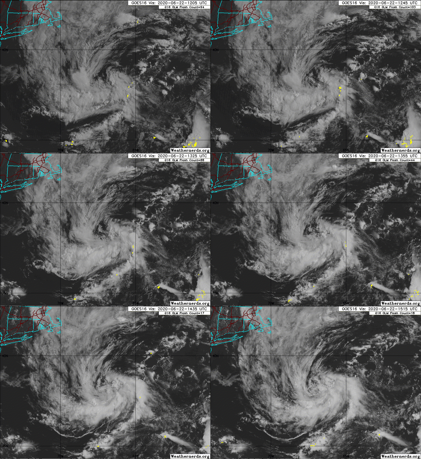
I would actually beg to differ, it's become much more organized lately and a brief subtropical cyclone looks somewhat probable. I'd give it around a 40% chance at the moment with it's current organizational trend.
1 likes   

Sciencerocks
Category 5
Category 5
Posts: 7286
Age: 38
Joined: Thu Jul 06, 2017 1:51 am

Re: ATL: INVEST 95L - Discussion

#18 Postby Sciencerocks » Mon Jun 22, 2020 11:21 am

Kiko Snowe wrote:I would actually beg to differ, it's become much more organized lately and a brief subtropical cyclone looks somewhat probable. I'd give it around a 40% chance at the moment with it's current organizational trend.


I agree!
Image
0 likes   

User avatar
StruThiO
Category 3
Category 3
Posts: 821
Age: 24
Joined: Fri Sep 15, 2017 5:51 am
Location: Currently Portland, OR. Raised in Jax, FL.

Re: ATL: INVEST 95L - Discussion

#19 Postby StruThiO » Mon Jun 22, 2020 11:38 am

0 likes   

User avatar
Hurricanehink
S2K Supporter
S2K Supporter
Posts: 2022
Joined: Sun Nov 16, 2003 2:05 pm
Location: New Jersey

Re: ATL: INVEST 95L - Discussion

#20 Postby Hurricanehink » Mon Jun 22, 2020 12:38 pm

Chris 2012 anyone?
0 likes   


Return to “2020”

Who is online

Users browsing this forum: No registered users and 66 guests