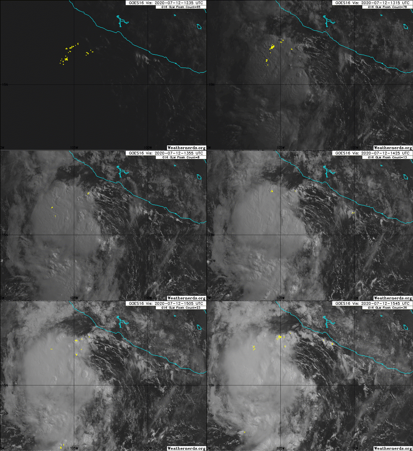
EPAC: SIX-E - Remnants
Moderator: S2k Moderators
- Nancy Smar
- Category 5

- Posts: 1081
- Age: 23
- Joined: Wed Aug 16, 2017 10:03 pm
- cycloneye
- Admin

- Posts: 139027
- Age: 67
- Joined: Thu Oct 10, 2002 10:54 am
- Location: San Juan, Puerto Rico
Re: EPAC: INVEST 98E
Tropical Weather Outlook
NWS National Hurricane Center Miami FL
500 AM PDT Sat Jul 11 2020
For the eastern North Pacific...east of 140 degrees west longitude:
The National Hurricane Center is issuing advisories on Tropical
Storm Cristina, located several hundred miles west-southwest of the
southern tip of the Baja California peninsula.
A broad low pressure system that has developed southwest of the
Gulf of Tehuantepec is producing a large area of disorganized
showers and thunderstorms. Although upper-level winds are currently
unfavorable for development of a tropical cyclone, environmental
conditions are expected to become more conducive for the formation
of a tropical depression in two to three days while the system
moves quickly westward, well south of the coast of Mexico.
* Formation chance through 48 hours...low...30 percent.
* Formation chance through 5 days...high...70 percent.
$$
Forecaster Stewart
0 likes
Visit the Caribbean-Central America Weather Thread where you can find at first post web cams,radars
and observations from Caribbean basin members Click Here
and observations from Caribbean basin members Click Here
- cycloneye
- Admin

- Posts: 139027
- Age: 67
- Joined: Thu Oct 10, 2002 10:54 am
- Location: San Juan, Puerto Rico
Re: EPAC: INVEST 98E
Tropical Weather Outlook
NWS National Hurricane Center Miami FL
1100 AM PDT Sat Jul 11 2020
For the eastern North Pacific...east of 140 degrees west longitude:
The National Hurricane Center is issuing advisories on Tropical
Storm Cristina, located several hundred miles west-southwest of the
southern tip of the Baja California peninsula.
1. A low pressure system located a couple of hundred miles southeast
of Acapulco, Mexico, has become a little better defined this
morning. Although upper-level winds are currently only marginally
conducive for development of a tropical cyclone, environmental
conditions are expected to become more favorable for the formation
of a tropical depression in two or three days while the system
moves quickly west-northwestward to westward, well south of the
coast of Mexico.
* Formation chance through 48 hours...medium...50 percent.
* Formation chance through 5 days...high...80 percent.
Forecaster Stewart
0 likes
Visit the Caribbean-Central America Weather Thread where you can find at first post web cams,radars
and observations from Caribbean basin members Click Here
and observations from Caribbean basin members Click Here
- cycloneye
- Admin

- Posts: 139027
- Age: 67
- Joined: Thu Oct 10, 2002 10:54 am
- Location: San Juan, Puerto Rico
Re: EPAC: INVEST 98E
12z ECMWF is now with GFS.
1 likes
Visit the Caribbean-Central America Weather Thread where you can find at first post web cams,radars
and observations from Caribbean basin members Click Here
and observations from Caribbean basin members Click Here
- Yellow Evan
- Professional-Met

- Posts: 15951
- Age: 25
- Joined: Fri Jul 15, 2011 12:48 pm
- Location: Henderson, Nevada/Honolulu, HI
- Contact:
Re: EPAC: INVEST 98E
Not sure why this is at 50/80 if I’m being honest. 30/40 is pushing it.
1 likes
- Kingarabian
- S2K Supporter

- Posts: 15433
- Joined: Sat Aug 08, 2009 3:06 am
- Location: Honolulu, Hawaii
-
AveryTheComrade
- Tropical Depression

- Posts: 76
- Joined: Fri Jul 10, 2020 9:19 pm
Re: EPAC: INVEST 98E
I feel that 50/80 is far too optimistic for this system, HWRF and HMON seem to be the only convincing models that have it developing
0 likes
- Kingarabian
- S2K Supporter

- Posts: 15433
- Joined: Sat Aug 08, 2009 3:06 am
- Location: Honolulu, Hawaii
Re: EPAC: INVEST 98E
The reason this is 50/80 is because the models were developing it for the past week. Today the models stopped upon it being designated as an Invest.
0 likes
RIP Kobe Bryant
- Kingarabian
- S2K Supporter

- Posts: 15433
- Joined: Sat Aug 08, 2009 3:06 am
- Location: Honolulu, Hawaii
Re: EPAC: INVEST 98E
I'm not sure what's stopping this from developing TBH. GFS wind shear forecast is favorable in its path along with good RH levels and sufficiently warm SST's.
0 likes
RIP Kobe Bryant
- Yellow Evan
- Professional-Met

- Posts: 15951
- Age: 25
- Joined: Fri Jul 15, 2011 12:48 pm
- Location: Henderson, Nevada/Honolulu, HI
- Contact:
Re: EPAC: INVEST 98E
Kingarabian wrote:I'm not sure what's stopping this from developing TBH. GFS wind shear forecast is favorable in its path along with good RH levels and sufficiently warm SST's.
12z GFS races this into a high shear environment. If it slows down, conditions could be more conducive.
0 likes
Re: EPAC: INVEST 98E
Kingarabian wrote:The reason this is 50/80 is because the models were developing it for the past week. Today the models stopped upon it being designated as an Invest.
Every time...models hype it up for a week, and as soon as it’s designated, they give up on it and hype the next system.
2 likes
Irene '11 Sandy '12 Hermine '16 5/15/2018 Derecho Fay '20 Isaias '20 Elsa '21 Henri '21 Ida '21
I am only a meteorology enthusiast who knows a decent amount about tropical cyclones. Look to the professional mets, the NHC, or your local weather office for the best information.
I am only a meteorology enthusiast who knows a decent amount about tropical cyclones. Look to the professional mets, the NHC, or your local weather office for the best information.
- Kingarabian
- S2K Supporter

- Posts: 15433
- Joined: Sat Aug 08, 2009 3:06 am
- Location: Honolulu, Hawaii
Re: EPAC: INVEST 98E
Yellow Evan wrote:Kingarabian wrote:I'm not sure what's stopping this from developing TBH. GFS wind shear forecast is favorable in its path along with good RH levels and sufficiently warm SST's.
12z GFS races this into a high shear environment. If it slows down, conditions could be more conducive.
Looks pretty clear @ 200mb, no?

0 likes
RIP Kobe Bryant
-
Sciencerocks
- Category 5

- Posts: 7282
- Age: 38
- Joined: Thu Jul 06, 2017 1:51 am
Re: EPAC: INVEST 98E
Wow, that is pretty well organized within my opinion. Not exactly next even without much model support!


1 likes
- Yellow Evan
- Professional-Met

- Posts: 15951
- Age: 25
- Joined: Fri Jul 15, 2011 12:48 pm
- Location: Henderson, Nevada/Honolulu, HI
- Contact:
Re: EPAC: INVEST 98E
Sciencerocks wrote:Wow, that is pretty well organized within my opinion. Not exactly next even without much model support!
https://imagizer.imageshack.com/img924/6019/1J9AJA.gif
Maybe it’ll briefly become a TD or a very weak TS before poofing.
1 likes
Irene '11 Sandy '12 Hermine '16 5/15/2018 Derecho Fay '20 Isaias '20 Elsa '21 Henri '21 Ida '21
I am only a meteorology enthusiast who knows a decent amount about tropical cyclones. Look to the professional mets, the NHC, or your local weather office for the best information.
I am only a meteorology enthusiast who knows a decent amount about tropical cyclones. Look to the professional mets, the NHC, or your local weather office for the best information.
- Yellow Evan
- Professional-Met

- Posts: 15951
- Age: 25
- Joined: Fri Jul 15, 2011 12:48 pm
- Location: Henderson, Nevada/Honolulu, HI
- Contact:
Re: EPAC: INVEST 98E
Showers and thunderstorms have increased this morning in association
with a small low pressure system located a couple of hundred miles
south of Manzanillo, Mexico. Environmental conditions are forecast
to gradually become more favorable for development, and a tropical
depression is likely to form within the next few days as the system
moves quickly west-northwestward to westward, well south of the
coast of Mexico.
* Formation chance through 48 hours...medium...60 percent.
* Formation chance through 5 days...high...70 percent.
0 likes
- Yellow Evan
- Professional-Met

- Posts: 15951
- Age: 25
- Joined: Fri Jul 15, 2011 12:48 pm
- Location: Henderson, Nevada/Honolulu, HI
- Contact:
- Kingarabian
- S2K Supporter

- Posts: 15433
- Joined: Sat Aug 08, 2009 3:06 am
- Location: Honolulu, Hawaii
Re: EPAC: INVEST 98E
Yellow Evan wrote:12/1730 UTC 15.9N 104.4W T1.5/1.5 98E -- East Pacific
It's getting close.
0 likes
RIP Kobe Bryant
- Yellow Evan
- Professional-Met

- Posts: 15951
- Age: 25
- Joined: Fri Jul 15, 2011 12:48 pm
- Location: Henderson, Nevada/Honolulu, HI
- Contact:
Re: EPAC: INVEST 98E
GFS and ECMWF if anything have this weakening. I have deep reservations on formation.
1 likes
Who is online
Users browsing this forum: No registered users and 61 guests


